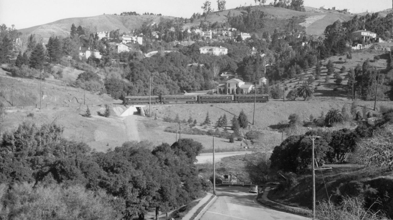
The White House of Rockridge Curve

Rockridge Curve with its palm trees and its own “White House” are all captured in this north view from Golden Gate Ave., Feb. 28, 1939. This landmark will focus specifically on the house.
L14-01-Wilbur C Whittaker Photo, Courtesy Arnold Menke and Garth Groff , (Image 1 of 16)

As presented in the Mainline section of Chabot Canyon, a constant in images of Rockridge Curve from the 1930s onward is a solitary white house and a concrete overpass for the SN at the Oakland-Berkeley border.
L14-05-Copyright California Department of Transportation, Detail B48, (Image 2 of 16)

The building was the Claremont Laboratory, completed by the East Bay Municipal Utility District in 1930, here in a undated photo, north view. The lab conducted quality checks on the area's water. Why was it on Rockridge Curve .... ?
L14-10-Courtesy of East Bay Municipal Utility District, P-PP-19, (Image 3 of 16)

The East Bay Municipal Utility District delivers water to the west side of the East Bay Hills using a 3.4 mile tunnel from Orinda. The Claremont Tunnel was completed in 1929, and this scene shows the tunnel's West Portal and the associated Rockridge Siphon, northeast view, Aug. 23, 1927. Note the presence of the SN concrete overpass.
L14-15-C.E. Grundy, Jr. Photo, Courtesy of East Bay Municipal Utility District, P-AQ-19, (Image 4 of 16)

The Rockridge Siphon delivered water to the local area from the portal, the siphon's large pipes shown here snaking underneath a temporary detour for SN train passage. Northeast view, Aug. 23, 1927.
L14-20-C.E. Grundy, Jr. Photo, Courtesy of East Bay Municipal Utility District, P-AQ-20 , (Image 5 of 16)

A west view of the Rockridge Siphon shows its relationship to the SN temporary detour and the main right-of-way from Aug. 16, 1927.
L14-25-Swadley of San Francisco Photo, Courtesy of East Bay Municipal Utility District, P-AQ-21, (Image 6 of 16)

This undated north view of the Claremont Lab shows its relationship to the West Portal of the Claremont Tunnel. Note the sparse vegetation. The house above on the hill still resides to the north side of the cul-de-sac of Roble Court, but today the face seen in this image is totally obscured by trees.
L14-30-Courtesy of East Bay Municipal Utility District, P-PP-17, (Image 7 of 16)

A rear view of the Claremont Laboratory, south view, Nov. 11, 1943. The increase in the amount of vegetation will also be reflected in the next two images ...
L14-35-Courtesy of East Bay Municipal Utility District, P-PP-48, (Image 8 of 16)

A view of the west side of the lab, also from Nov. 11, 1943.
L14-40-Courtesy of East Bay Municipal Utility District, P-PP-47, (Image 9 of 16)

Also from 1943, this north view of a SN 660-led freight captures the lab and the increase in vegetation on the south face, the portal, the concrete bridge over the roadway to the lab, and the signature palm tree of Rockridge Curve. Note the hood on the motor’s main light as a means to reduce upwardly directed or reflected light during wartime.
L14-45-Charles Savage Photo, Courtesy Tom Gray , (Image 10 of 16)

Now to 1948, and SN 603, 604 and an unidentified motor on the rear bring the Birney car #62 from Sacramento to Oakland in this north view. Today, this image and the previous one would be obscured by the Seneca Center, built as the Rock LaFleche School by Alameda County in the 1970s.
L14-50-Arthur Lloyd Photo, Courtesy Arthur Lloyd, (Image 11 of 16)

Taken from the area of the former concrete overpass, the Claremont Laboratory and its environs were drastically revised in the late 1990s such that the exterior of the building is no longer identifiable. The complex is now known as the Claremont Center Pumping Plant.
L14-55-Stuart Swiedler Photo, (Image 12 of 16)

The steps and foundation of the original laboratory remain preserved as seen here from an aerial view.
L14-57-Courtesy Google Maps, (Image 13 of 16)

A east-bound freight with SN 606 at the rear is seen crossing the concrete bridge in the 1950-53 time period, north view. SN 606 was renumbered 646 in 1953 according to Demoro's Sacramento Northern.
L14-60-EK Muller Photo, Courtesy BAERA, Western Railway Museum Archive, 45005sn , (Image 14 of 16)

A west-bound freight with three motors was captured just as it crossed the western portion of the concrete overpass in this west view from 1955. This retaining wall was removed in the late 1990s when the site was revised, but we all forgot to get a picture!
L14-65-Courtesy Ray Raineri , (Image 15 of 16)

A similar west view as L14-65, the rail path and the houses above the curve are barely visible. Before concluding, the Claremont Tunnel was seismically strengthened in the mid-2000s as a 1,570-foot-long tunnel bypass was installed at the Hayward fault - see http://ebmud.com/sites/default/files/pdfs/Earthquake_Readiness_0.pdf
L14-70-Stuart Swiedler Photo, (Image 16 of 16)