Once Upon a Time at Thornhill Drive

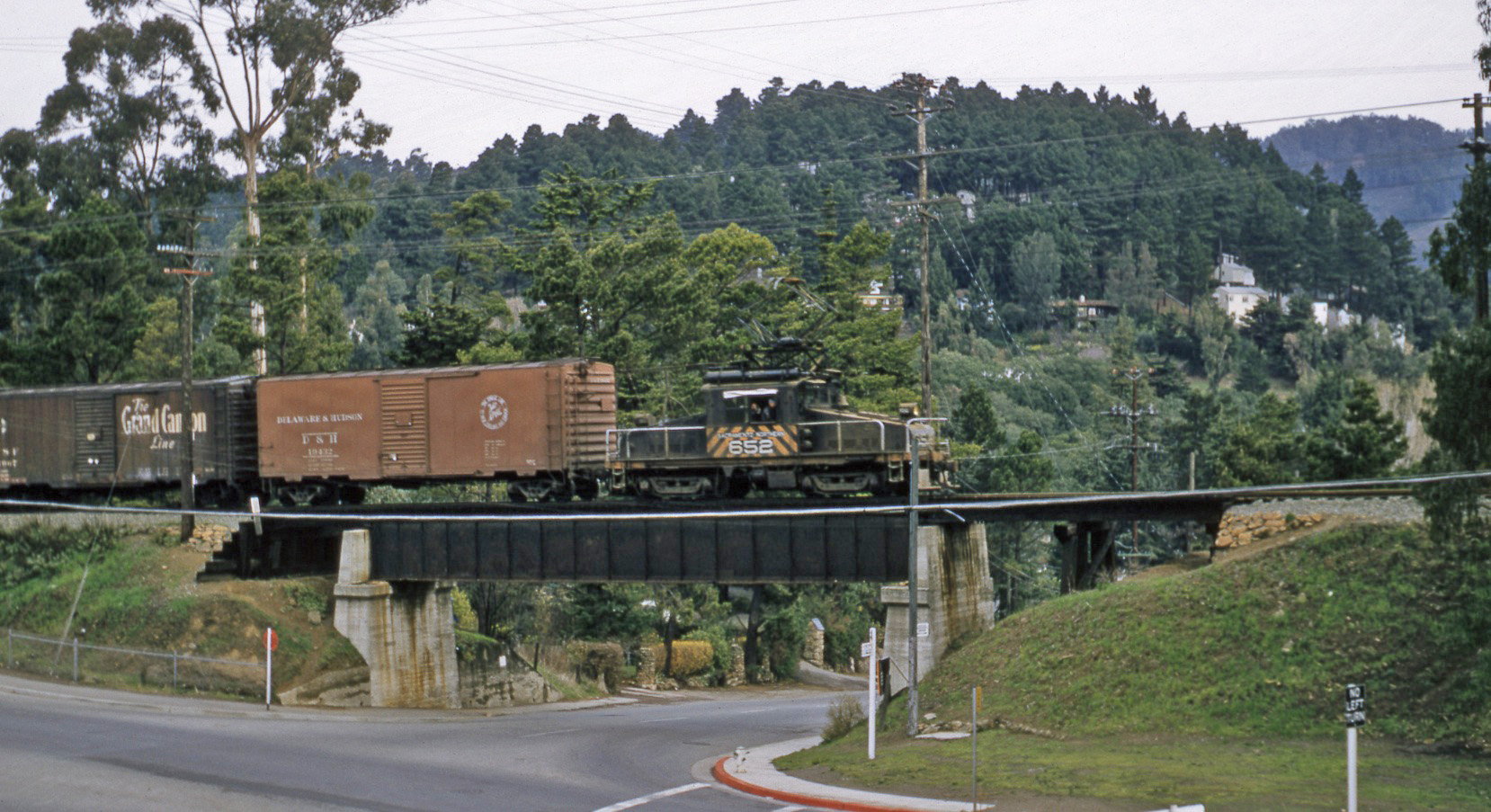
SN 652 leads a freight onto the overpass of Thornhill Drive on February 9, 1957, east view, just weeks prior to railway abandonment. This important intersection was once crossed by a wooden trestle, and served as a route of a 19th century toll road connecting Alameda and Contra Costa Counties.
L72-05-Richard Kampa Photo, Courtesy BAERA, Western Railway Museum Archives, 58318sn, (Image 1 of 14)

This post-abandonment 1957 southeast view shows the approach to the raised steel edges of the overpass. To the west or right of the right-of-way is the incline of Moraga Ave., and further west is the Mountain Boulevard Freeway. Now back half a century ...
L72-10-Enrique K Muller Photo, Courtesy BAERA, Western Railway Museum Archives, 70936sn, (Image 2 of 14)

A 1910s similar southeast view, Moraga Ave. again prominent to the west. There is much folklore about Hiram Thorne and his lumber operations in Canyon. The Daily Alta California, Vol 15, 4768, Mar. 15, 1863 reported that he had won authorization from the California Senate to build a toll road connecting Alameda and Contra Costa Counties.
L72-15-Eston Cheney Photo B-1306, Courtesy BAERA, Western Railway Museum Archives, 24131sn , (Image 3 of 14)

Although the “e” on Thorn was dropped, the road serviced two cycles of redwood clearing, until circa 1935 when the name was changed to Thornhill Drive and diverted to Snake Rd. By the mid-1960s, the path of the toll road was truncated below Skyline Blvd. on the Alameda County side, and the path to Eastport eventually became part of the Huckleberry Botanic Regional Preserve. 1933 Map UCB Ref. G4363.A3P2 1933 .A5
L72-20-Courtesy Earth Sciences and Map Library, UC Berkeley, and Oakland Public Library, (Image 4 of 14)

The Oakland, Antioch and Eastern Railway initially constructed a trestle at the Thorn Rd. crossing, here seen circa 1930 in a northeast view during the structure’s initial transformation to an overpass.
L72-25-Vernon Sappers Collection, Coutesy BAERA, Western Railway Museum Archives, 70942sn, (Image 5 of 14)

The vehicles in this companion image of L72-20 provide the 1930 timeframe for the trestle reconfiguration. The image is the only west view from the east side of this intersection during the railway’s existence that has been found.
L72-30-Vernon Sappers Collection, Coutesy BAERA, Western Railway Museum Archives, 70943sn, (Image 6 of 14)

Charley Savage provided a date, Dec. 20, 1938, and documentation of milepost 12 on the catenary pole and on the crossing milepost marker at track level in this northwest view of a two-car train led by SN 1016 heading to Montclair station. Typically, the marker mileages were rounded to the mileage of the nearest milepost.
L72-35-Charles Savage Photo, Courtesy Tom Gray , (Image 7 of 14)

This circa 1938 southeast view complements L72-35 and provides a glimpse of a home to the west of the right-of-way. Based on several images, this particular real estate ad reads “Lake Temescal Studio Homes, F.H.A Terms”.
L72-40-Paul Smith Photo, Courtesy BAERA, Western Railway Museum Archives, 70941sn, (Image 8 of 14)

Its post-war 1945 based on the absence of the light hoods on the often paired tandem of SN 603 and SN 604, east view. East to Mountain Boulevard can be seen, marked by the car completing the turn from Thornhill Drive.
L72-45-Charles Savage Photo, Courtesy Tom Gray , (Image 9 of 14)

Tom Gray’s well-timed image from Apr. 22, 1950 of SN 604 and a Carnation truck, southeast view, provide street signs and an updated real estate sign, “Ione Jones, Licensed Real Estate Broker, for bargains in homes/homesites in Rockridge Montclair Fernwood Glenwood Forest Park Merriewood Pinehaven and Thornhill Park, Notary Public ...”
L72-50-Tom Gray Photo, Courtesy Tom Gray, (Image 10 of 14)

This southeast view taken during a circa 1956 excursion with SN 1005 and Salt Lake & Utah parlor car 751 reveal that the text on the real estate sign has been reduced to “Ione Jones, Real Estate Broker, Insurance, Notary”.
L72-55- Arthur Lloyd Photo, Courtesy Arthur Lloyd , (Image 11 of 14)

Now to 1955, a northwest view down the right-of-way prior to the completion of Mountain Boulevard Freeway Unit II that connected Moraga Ave. to Park Blvd. The crossbucks and grade crossing signals are in place to safely guide the SN across the roadway.
L72-60-Harre Demoro Photo, Courtesy John Harder , (Image 12 of 14)

By the spring of 1957, the freeway addition was complete and the grade crossing-related equipment at the freeway had been removed. Even though the SN right-of-way had been abandoned, note that the cars on the freeway wait for the crossing traffic on Moraga Ave. to pass. The date of the removal of the overpass has not been determined. Northwest view.
L72-65-Enrique K Muller Photo, Courtesy BAERA, Western Railway Museum Archives, 70937sn, (Image 13 of 14)

Just in time to catch SN 653 at the back end of the freight led by SN 652 that started this update in L72-05. East view, Feb. 9, 1957.
L72-70-Richard Kampa Photo, Courtesy BAERA, Western Railway Museum Archives, 58319sn, (Image 14 of 14)