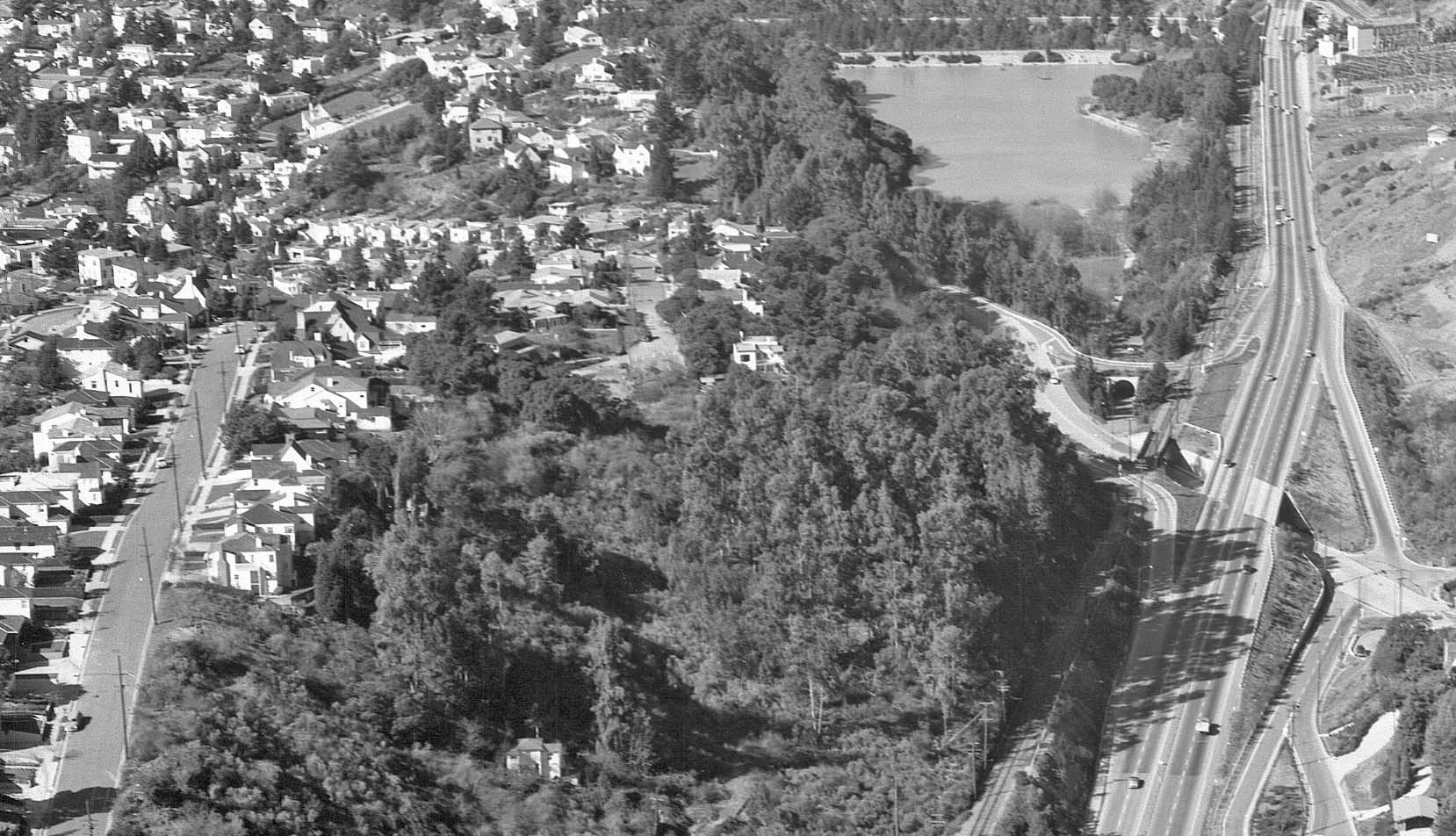
The Grade Crossing Exit and Entrance of Mountain Boulevard Freeway

This northwest view from Feb. 1, 1956 will introduce the construction of the unusual west exit and entrance lanes from Mountain Boulevard Freeway to Broadway Terrace and the impact on the the south entrance to Temescal Regional Park. The view of the neighborhood to the west is provided as a bonus to those residents of the area.
L82-05-Copyright California Department of Transportation, 4809-1 Detail, (Image 1 of 21)

To start, a west view up Broadway Terrace showing the entrance to Temescal Regional Park in 1950 prior to Mountain Boulevard Unit 2 construction. The abutment of the SN overpass of Broadway Terrace is to the right. The car license plate confirms the year.
L82-10-Public Works Photo, Oakland Cultural Heritage Survey, Oakland City Planning Department, (Image 2 of 21)

Another west view of the entrance to Temescal Regional Park, 1950.
L82-15-Public Works Photo, Oakland Cultural Heritage Survey, Oakland City Planning Department, (Image 3 of 21)

Construction has started in 1951 in this west view of the park entrance. Note the black license plates, confirming the year of construction.
L82-20-Public Works Photo, Oakland Cultural Heritage Survey, Oakland City Planning Department, (Image 4 of 21)

To create the northwest exit from the freeway to Broadway Terrace west, the roadway had to pass over the entrance to the park. An almost finished product, late 1951, north view. SN catenary pole and wires are seen along top of the image.
L82-25-Public Works Photo, Oakland Cultural Heritage Survey, Oakland City Planning Department, (Image 5 of 21)

Now going back in time to June 13, 1951, here the new freeway exit-park entrance at an earlier stage, north view.
L82-30-Public Works Photo, Oakland Cultural Heritage Survey, Oakland City Planning Department, (Image 6 of 21)

A northwest view from around mid-year 1951 showing the metal lining for the new park entrance.
L82-35-Public Works Photo, Oakland Cultural Heritage Survey, Oakland City Planning Department, (Image 7 of 21)

Moving even earlier into 1951, an early stage of the exit construction, north view.
L82-40-Public Works Photo, Oakland Cultural Heritage Survey, Oakland City Planning Department, (Image 8 of 21)

For completeness sake, four images from early 1951 showing various facets of the early construction of the supports for the northwest exit lane.
L82-45-Public Works Photo, Oakland Cultural Heritage Survey, Oakland City Planning Department, (Image 9 of 21)

Back to Broadway Terrace, an east view heading east towards the park entrance and SN overpass, late 1950, early 1951.
L82-50-Public Works Photo, Oakland Cultural Heritage Survey, Oakland City Planning Department, (Image 10 of 21)

Further east along Broadway Terrace, southeast view of the park entrance and SN overpass, late 1950, early 1951. Match this against the next image.
L82-55-Public Works Photo, Oakland Cultural Heritage Survey, Oakland City Planning Department, (Image 11 of 21)

Now ahead to late 1951, early 1952, and the northwest exit from the freeway to Broadway Terrace west is complete.
L82-60-Public Works Photo, Oakland Cultural Heritage Survey, Oakland City Planning Department, (Image 12 of 21)

The excursion with SN 1005 and MW 302 pause at the grade crossing before crossing the new northwest exit from the freeway, north view, August 10, 1952.
L82-65-Arthur Lloyd Photo, Courtesy Arthur Lloyd, (Image 13 of 21)

A south view of the last freight to use the grade crossing, Feb. 28, 1957, captured midway across the northwest exit in this south view. SN 653 pushes from behind, and the Birney car 62 appears compressed at the second catenary pole from the right due to the angle of the shot.
L82-70-LL Stein Photo, Courtesy BAERA, Western Railway Museum Archives, 69443sn, (Image 14 of 21)

Finally, some consideration of the southwest entrance from Broadway Terrace onto the freeway. Southeast view, late 1950, early 1951. Match this against the next image.
L82-75-Public Works Photo, Oakland Cultural Heritage Survey, Oakland City Planning Department, (Image 15 of 21)

The entrance to the freeway is graded up to the grade crossing in this 1951 southeast view, the date confirmed by the license plates on the cars.
L82-80-Public Works Photo, Oakland Cultural Heritage Survey, Oakland City Planning Department, (Image 16 of 21)

A north view from 1951 showing the entrance lane south of the grade crossing during the early stages of grading.
L82-85-Public Works Photo, Oakland Cultural Heritage Survey, Oakland City Planning Department, (Image 17 of 21)

A north view from 1952 showing the completed southwest entrance ramp.
L82-87-Public Works Photo, Oakland Cultural Heritage Survey, Oakland City Planning Department, (Image 18 of 21)

SN 670 pushes a west-bound freight past the southwest freeway entrance in this northwest view post-1952, but before the motor was put out of service in 1954.
L82-90-Dave Gumz Photo, Courtesy BAERA, Western Railway Museum Archives, 69444sn, (Image 19 of 21)

For completeness, a south view of the southwest freeway entrance with SN 653 at the rear of a freight, the crossing soon to accept car traffic to enter the freeway.
L82-92-EK Muller Photo, Courtesy BAERA, Western Railway Museum Archives,78988sn, (Image 20 of 21)

The creation of grade crossings at exit and entrance lanes was thought to serve a very short term need in light of the Western Pacific’s efforts to abandon the SN right-of way in 1952, but in fact they were in use for 5 years. South view, 1952.
L82-95-Public Works Photo, Oakland Cultural Heritage Survey, Oakland City Planning Department, (Image 21 of 21)