The Durham-Oroville Junction Branch and Lorraine Revealed
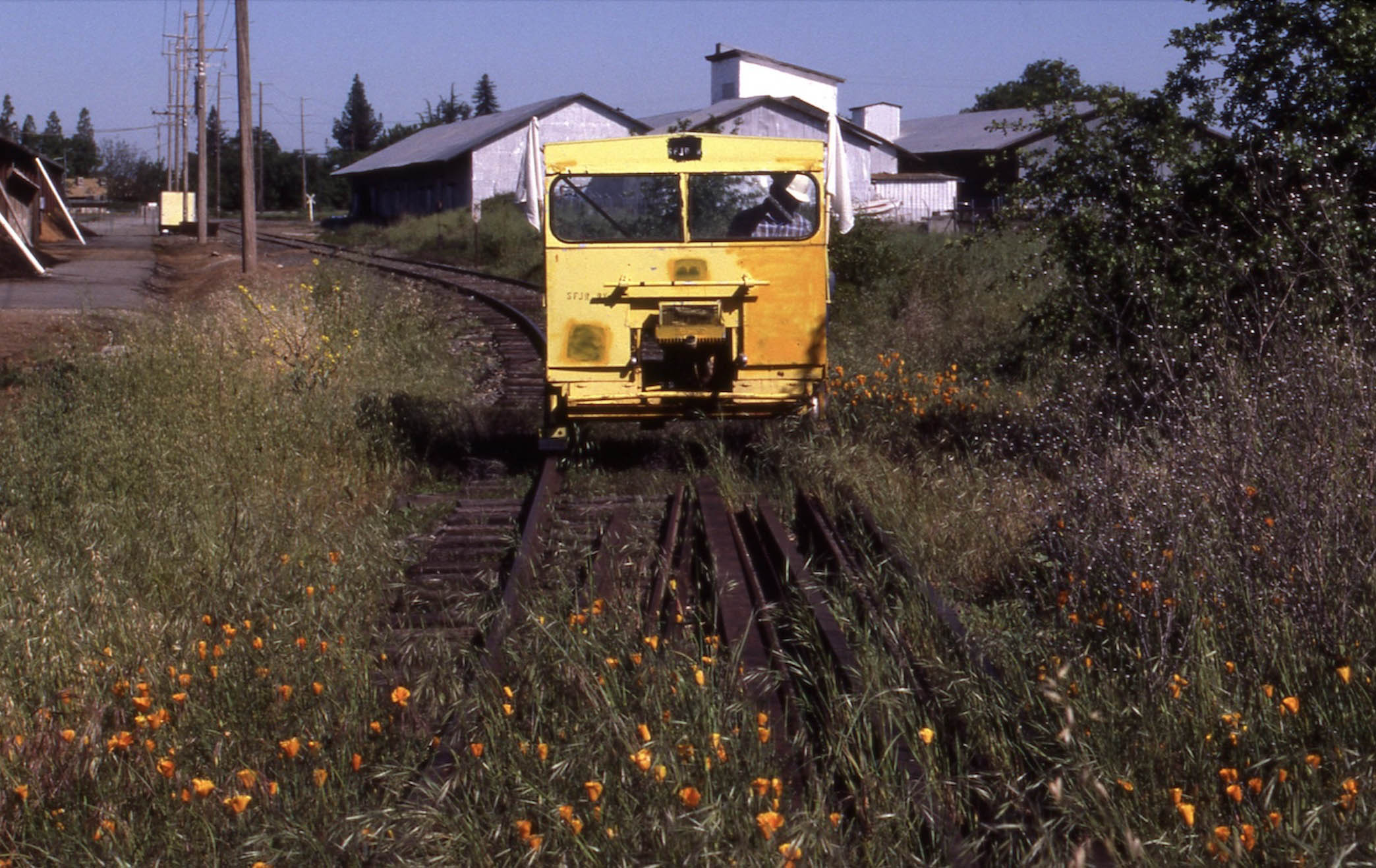
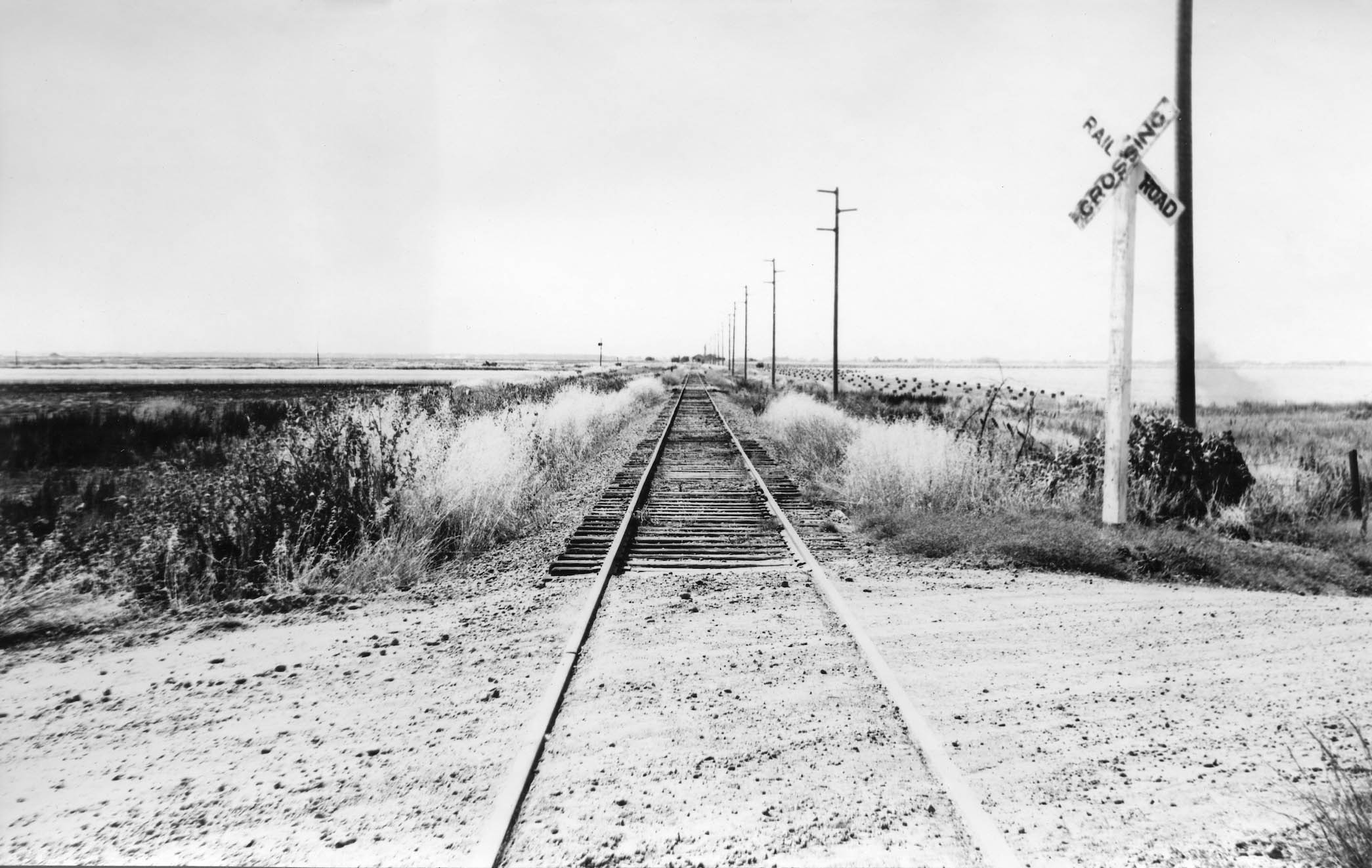
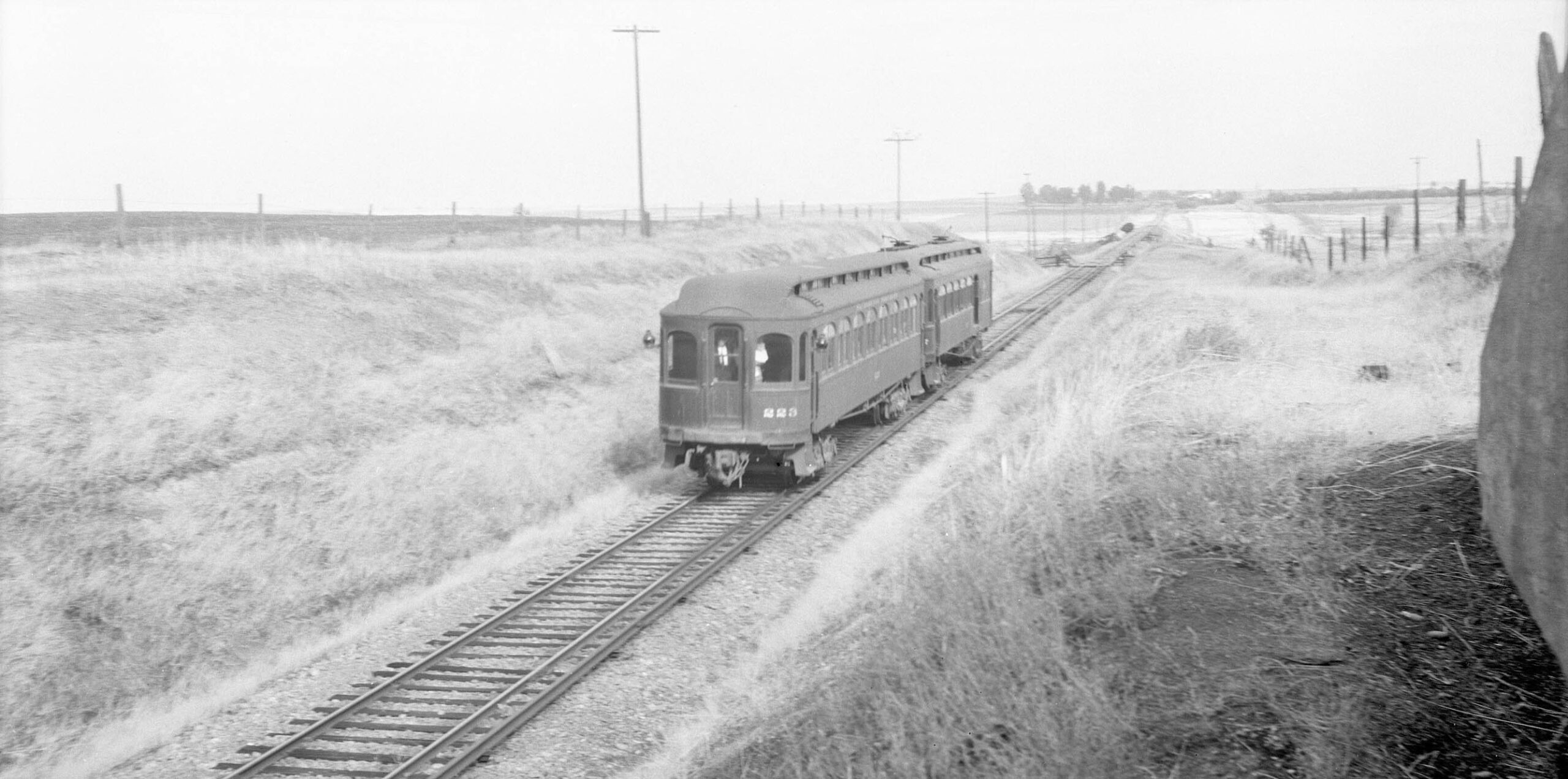
June 1, 1986. The Sacramento Northern Railway, SN, is defunct north of Yuba City, the Chico Local is no more. Tom Messer and friends are using a speeder to survey the former Durham-Oroville Jct. Branch that was abandoned on Aug. 18, 1971. Getting the car on the severed north end of the track just south of the Durham-Dayton Highway seen in the distance allowed for only a 1500 foot or so ride until the overgrowth and piled loose rail ended the journey. North view.
L323-05-Tom Messer Photo, Courtesy Wayne Monger, (Image 1 of 45)

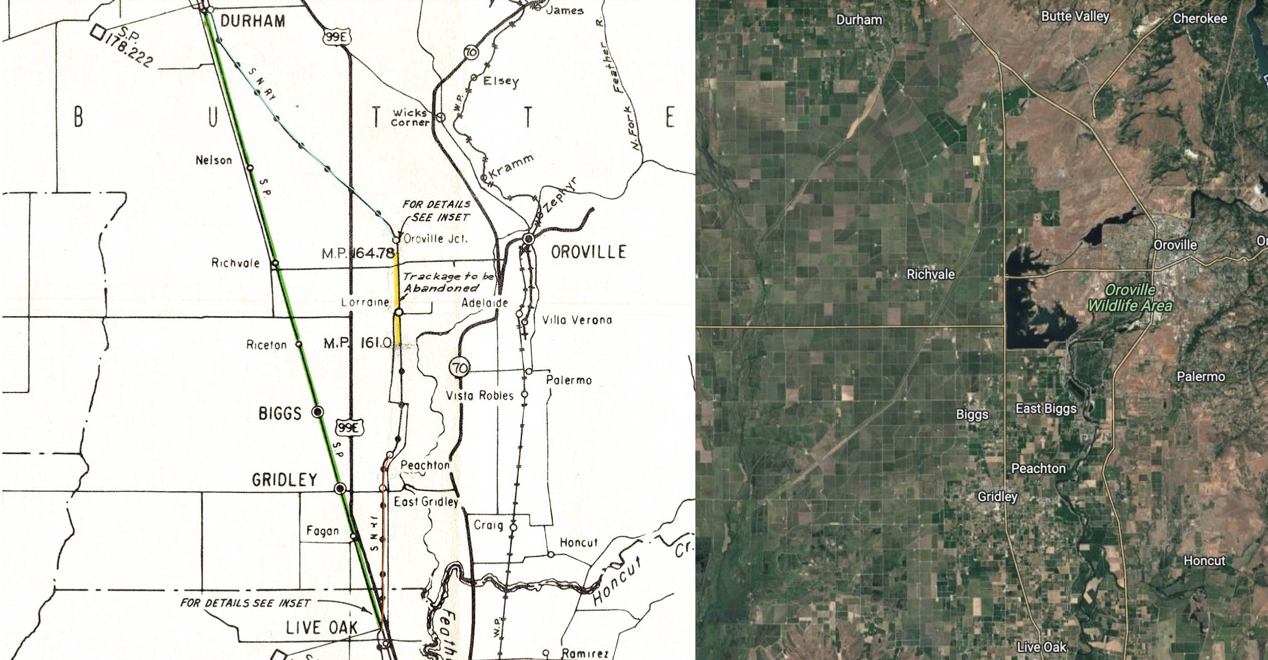
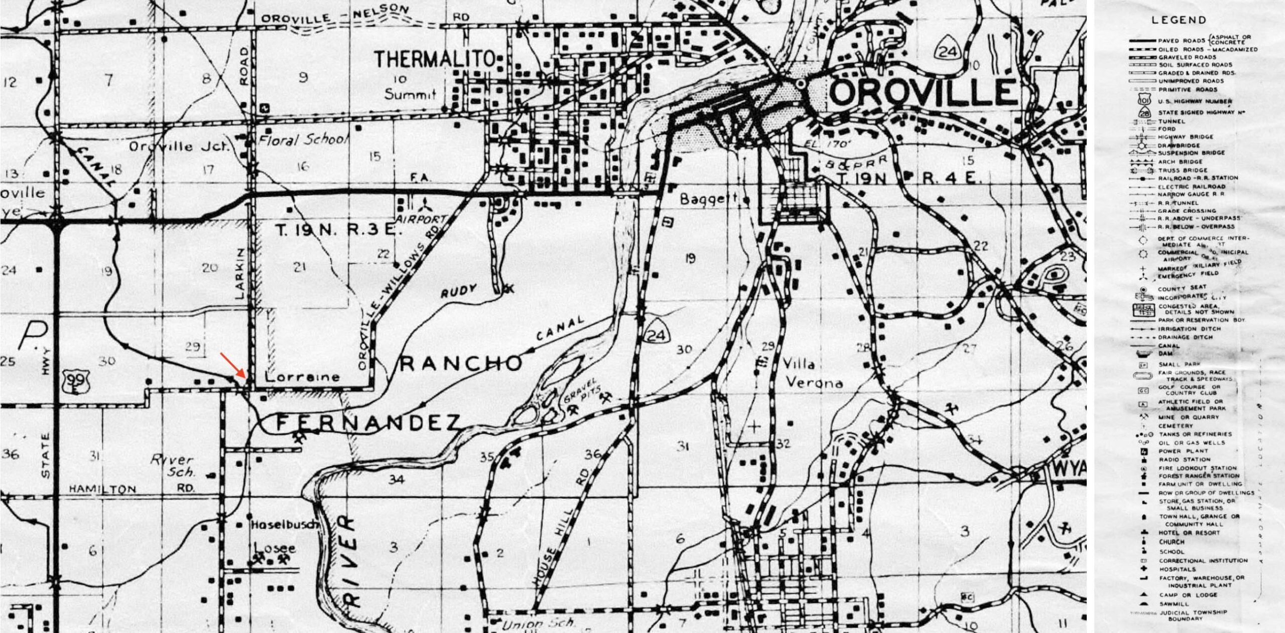
Related to the creation of the Oroville Dam Afterbay, the previous update established that the SN diverted its mainline between Durham and Live Oak to SP rails on Feb. 1, 1967, creating two branch lines serving Durham to Oroville Jct., turquoise line, and Live Oak to Peachton, orange line, respectively. The track between mileposts 161 and 164.78, including the Lorraine stop, would be abandoned, and the portion south to Peachton sit unused. This update will add background and cover the loss of Lorraine and the branch to Oroville Jct.
L323-10-Courtesy BAERA, Western Railway Museum Archives, 39641, (Image 2 of 45)
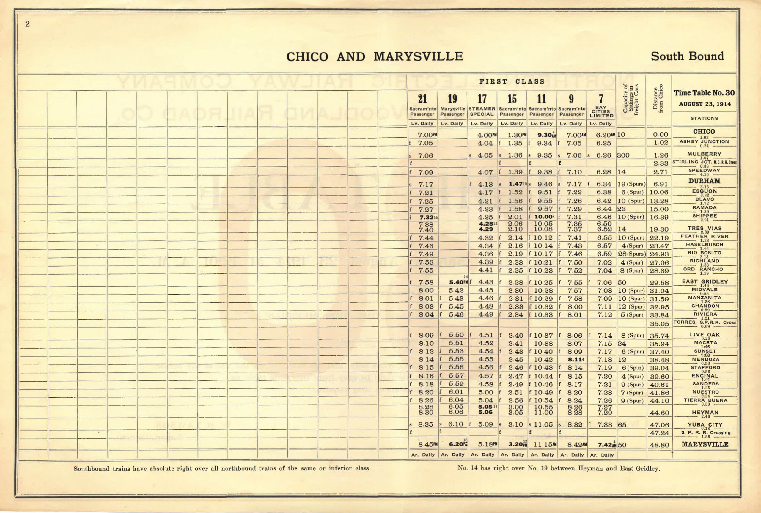
First, some background to cover the SN mainline between Durham and Live Oak, the section almost entirely within agriculture-rich Butte County. The Northern Electric, NE, 1914 timetable shows widely spaced stops between Durham and Richland, and much more closer intervals for stops between Ord Rancho and Live Oak. This spacing reflected the wide open spaces north of Ord Rancho. The timetable indicates all had track to accommodate freight. Feather River would be renamed Lorraine in the 1915 timetable, and Ord Ranch to Peachton in the 1924 version.
L323-15-Courtesy BAERA, Western Railway Museum Archives, 13552, (Image 3 of 45)
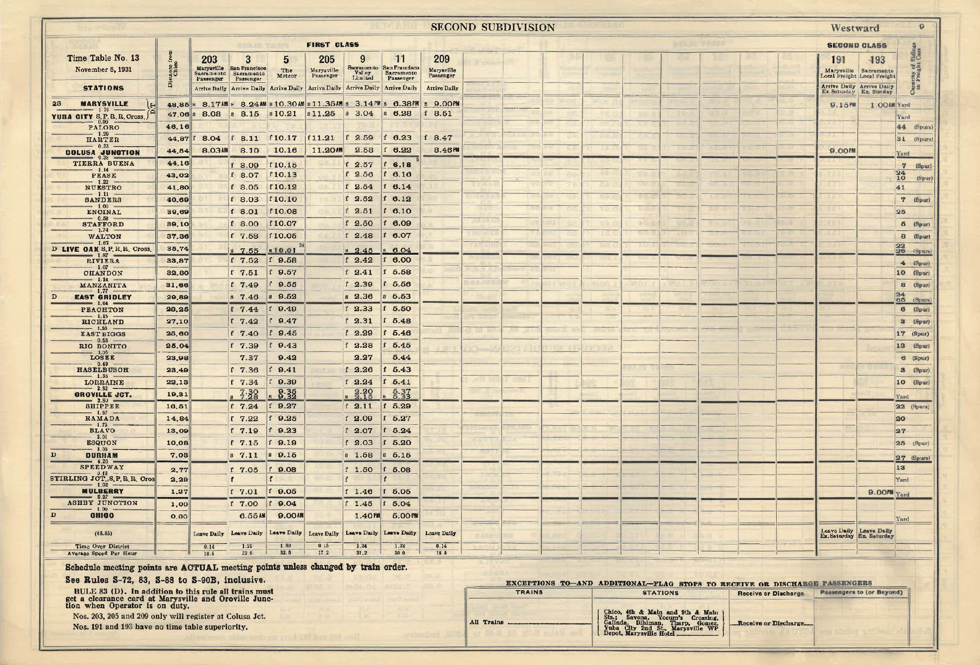
By 1931, the merged Sacramento Northern Railway from Chico to San Francisco shows other stops that had been added over the previous decade and a half, the change from Tres Vias to Oroville Jct. in the 1925 timetable being the most notable. Note that the stop number and names north of Oroville Jct. to Durham remained unchanged from 1914, but the capacity for freight cars had increased.
L323-20-Courtesy BAERA, Western Railway Museum Archives, 13466, (Image 4 of 45)
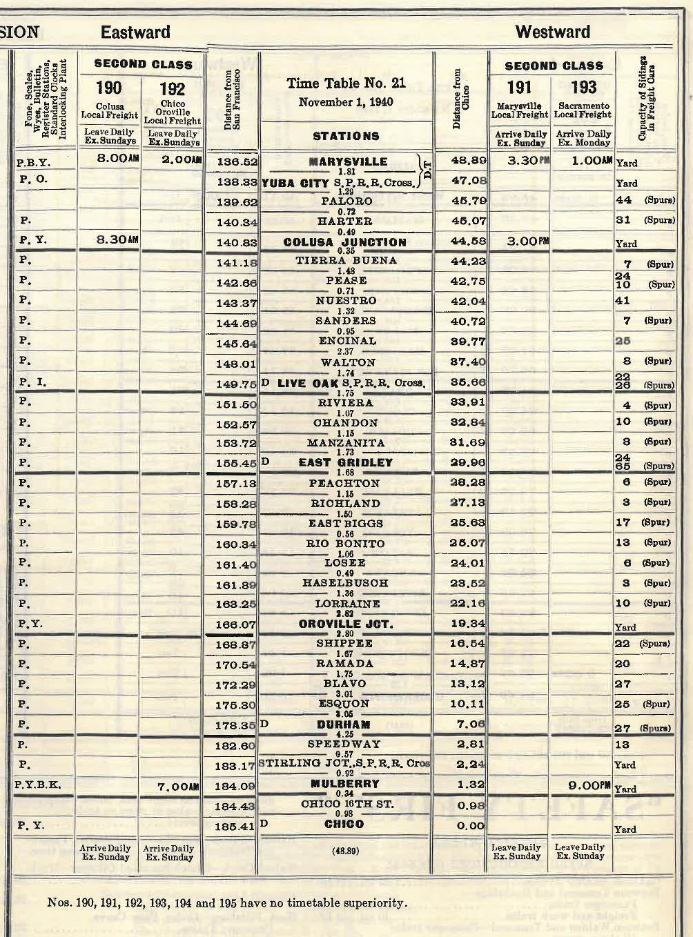
The Nov. 1, 1940 timetable shown here was published when passenger service north of Sacramento was discontinued, with no obvious impact on freight service.
L323-25-Courtesy BAERA, Western Railway Museum Archives, 13477, (Image 5 of 45)
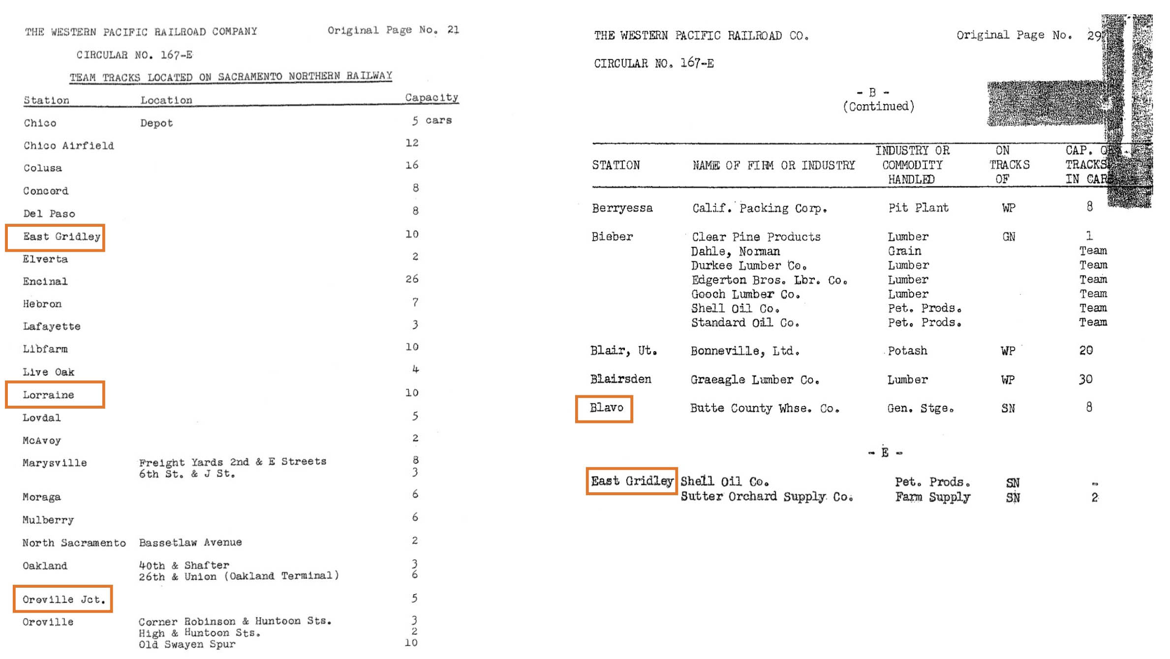
The surviving freight customers as of ca. 1957 according to the WP Circular No. 167-E ca. 1957 are shown here, noting that except for East Gridley, all customers were at or north of Lorraine. This does not reflect the addition of customers very shortly to Peachton shown in the next timetable, a topic to be discussed in detail in the next update.
L323-30-Courtesy Bruce Eldridge, (Image 6 of 45)
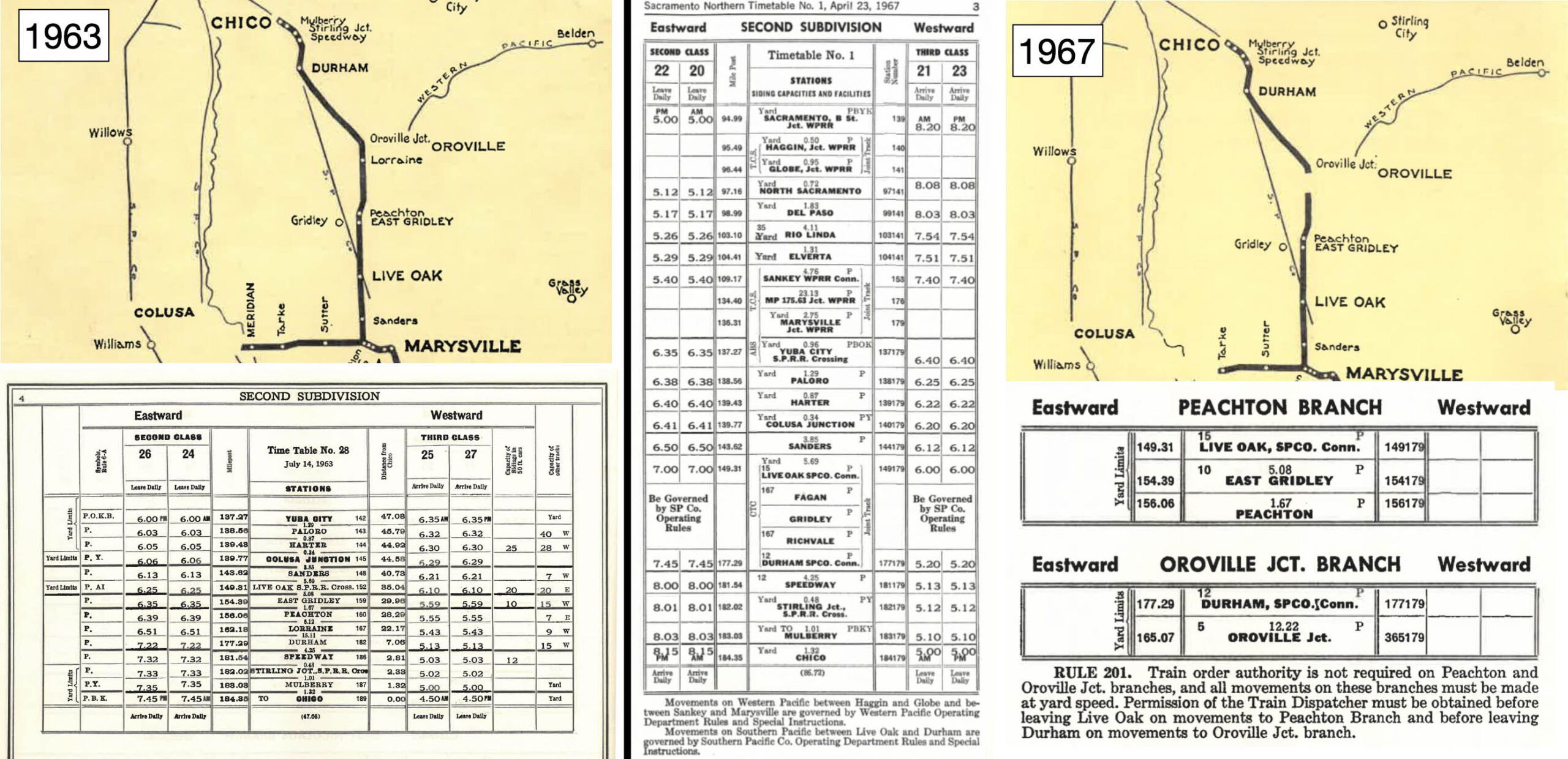
By 1963, left, the Lorraine team track was still listed, but the Afterbay was going to eliminate adjacent farms even if some arrangement had been made to keep the mainline intact. After the detour of the mainline in 1967, the timetable on the right indicates very little stops for freights servicing the branch lines.
L323-35-Coortesy BAERA, Western Railway Museum Archives, 13489, l, 13490, r, (Image 7 of 45)
Next to focus on Lorraine. As for ground shots, this single image that E.K. Mueller took of SN 143 and freight taken on Feb. 8, 1949 is all that could be attributed to this section, and where exactly cannot be determined. This is almost certainly a southwest view from the adjacent road as will be appreciated shortly.
L323-40-E. K. Mueller Photo, Courtesy BAERA, Western Railway Museum Archives, 184146sn, (Image 8 of 45)
To glean any additional information about Lorraine and the surrounding area, the focus will turn to aerial photography starting with this west view of Oroville from Oct. 31, 1955, left. The resolution of sections in the background are sufficient to begin examining the track between Oroville Jct. and Lorraine. The section boxed in green on the left is magnified on the right, and labeled with important landmarks pertinent to the current discussion. Next to review the view of the line from the Oro Dam Blvd. West overpass of the SN right-of-way.
L323-45-Copyright California Department of Transportation, 4610-08, (Image 9 of 45)
Looking south from the Oro Dam Blvd. West SN overpass ca. 1940, the “new” Oroville Jct. passenger station created after the flood of 1937 that led to the cessation of passenger service on the Oroville Branch can be seen with a bus shuttling passengers from the stopped train. Note how barren the area to the south is with the exception of the outline of the Sierra Buttes. The utility poles to the west of the track, and the low fence on the east flank are the same features present in the Mueller photo shown in L323-40.
L323-50-Vernon Sappers Collection, Courtesy BAERA, WEstern Railway Museum Archives, 106477sn, (Image 10 of 45)
From the same west-facing aerial from Oct. 31, 1955, the Oro Dam Blvd. West overpass is to the right, and the red straight redline projects to that area approximating the position of Lorraine. The barren landscape captured in the view from the overpass in L323-50 is reinforced by this image. Take note of the cluster of trees just to the right or north of the southern-most end of the red line, and the buildings at the end of the line. More details next.
L323-55-Copyright California Department of Transportation, 4610-08, (Image 11 of 45)
Another detail from the same west-facing aerial from Oct. 31, 1955, the cluster of trees is marked by the orange arrow, a creek or channel by the yellow arrow, the buildings by the green arrow, and the the bend in the Feather River by the blue arrow. The red box marks where the SN right-of-way would have encountered the creek or channel. To view this, a different view of the area will be presented next.
L323-60-Copyright California Department of Transportation, 4610-08, (Image 12 of 45)
Several lines of evidence can be provided to establish the location of Lorraine. First, this detail from a map of Butte County from 1946, shows the position of Lorraine, red arrow,. Ref: Full Title: Map of Butte County, California. Compiled and published by Thomas Bros. ; copyright by Harry Freese. G4363 B8 1946 T6. Deposited at Meriam Library, California State University, Chico.
L323-65-Courtesy Meriam Library, California State University, Chico, ca_2044, (Image 13 of 45)
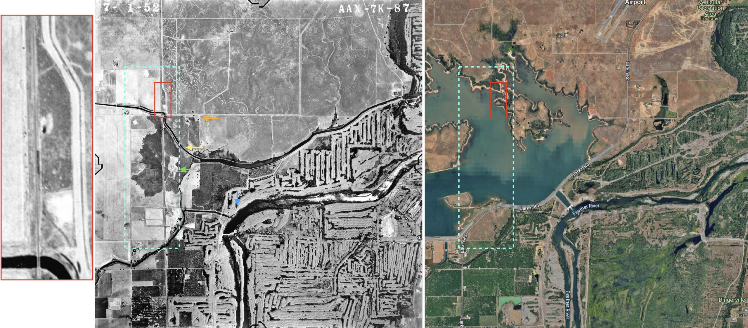
Second, the aerial from 1952 on the left is marked by the same arrows as in the previous oblique aerial. The aerial on the right from 2025 is included to leave no doubt that the area being studied here is now covered by the water of the Afterbay. A closer look into the red box, far left, shows the anticipated SN trestle over the waterway, and, by chance, a string of three freight cars on an adjacent siding to the east of the mainline. The latter finding suggests a very likely candidate for the Lorraine team track. The area boxed in turquoise is up next.
L323-67-aax-1952_7k-87, Courtesy of UCSB Library Geospatial Collection, l and c, Courtesy Google Earth, r, (Image 14 of 45)
On Oct. 8, 1960, the California Dept. of Water Resources conducted an aerial survey from an altitude of 1500-2000 ft. of the area to be converted to the Afterbay. For the aerial on the left, west is at the top, and north to the right. It shows the trestle just north of the SN Haselbusch station, followed by a red line indicating the southern border of the planned afterbay to the west, the green line where the SN line was truncated. Those subjects will be covered in an future update. On the right, a property right at this latter border. Everything to the right of the green line is now part of the Thermalito Afterbay, and the subject of what follows.
L323-70-Courtesy California Department of Water Resources, 4_64 top, 5_84, bottom, l, 5_84, r, (Image 15 of 45)
Same date and orientation, but now north of the previous aerial, the left panel shows the next part of the SN mainline, running across the middle, and Larkin Rd., running across the top, lost to the Afterbay. There does not appear to be a written history of the type of farms-ranches that existed in this section. In the right panel is a detail from the blue boxed area on the left that was one of the larger operations right along the SN track. The area is densely planted with orchards. The roads to the farm are well developed, and there is no SN spur servicing it.
L323-72-Courtesy California Department of Water Resources, 4_66, top, 5_86, bottom, l, 5_86, r, (Image 16 of 45)
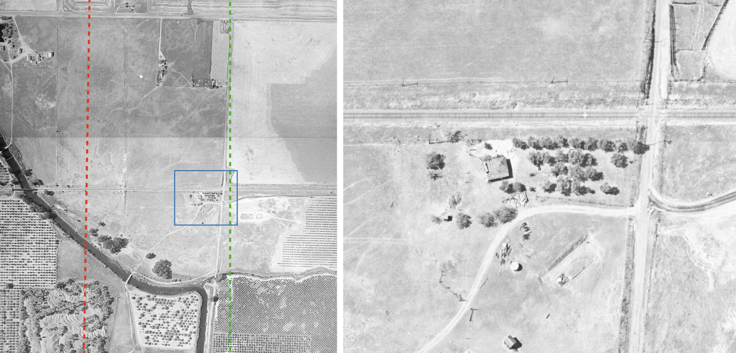
Further north is a channel or canal running east-west. Larkin Rd. is seen heading east just to the south of the canal. The property in the blue box is detailed on the right. It sits at the north end of fully cultivated land. At least three of the buildings are in disrepair. The property near the lower border will be discussed in the next set of panels. Note the orange arrow pointing to a SN bridge over the canal, just to the north of the Larkin Rd. grade crossing. This area is detailed in the next image to follow.
L323-74-Courtesy California Department of Water Resources, 4_67, top, 5_87, bottom, r, 4_67, r, (Image 17 of 45)
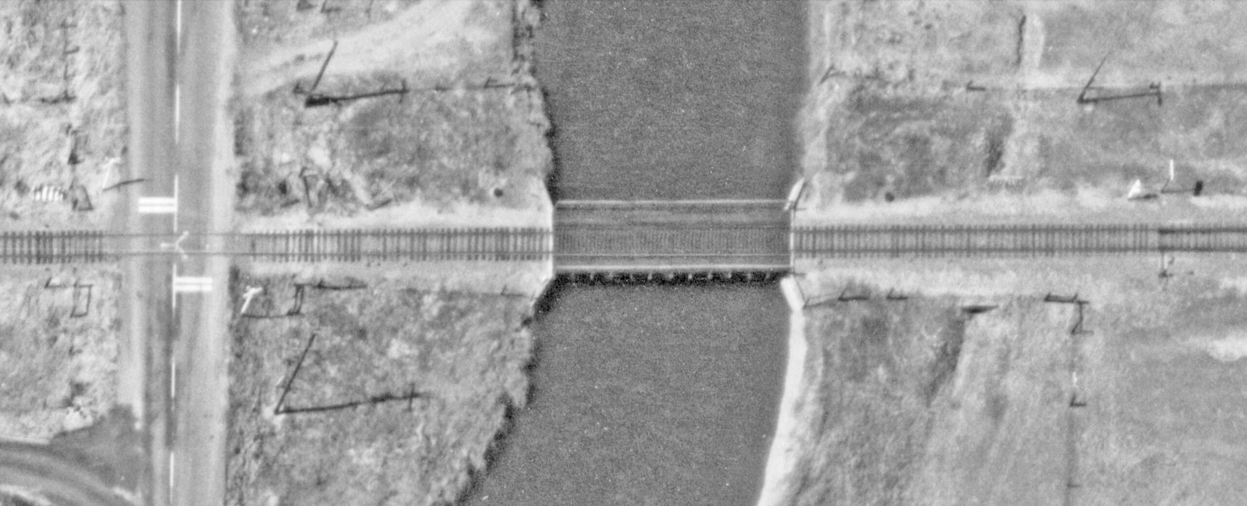
Shown here is a detail from the previous aerial view from Oct. 8, 1960 showing the Larkin Rd. grade crossing to the south or left, and the SN bridge over the canal to its right or north.
L323-76-Courtesy California Department of Water Resources, 5_87, (Image 18 of 45)
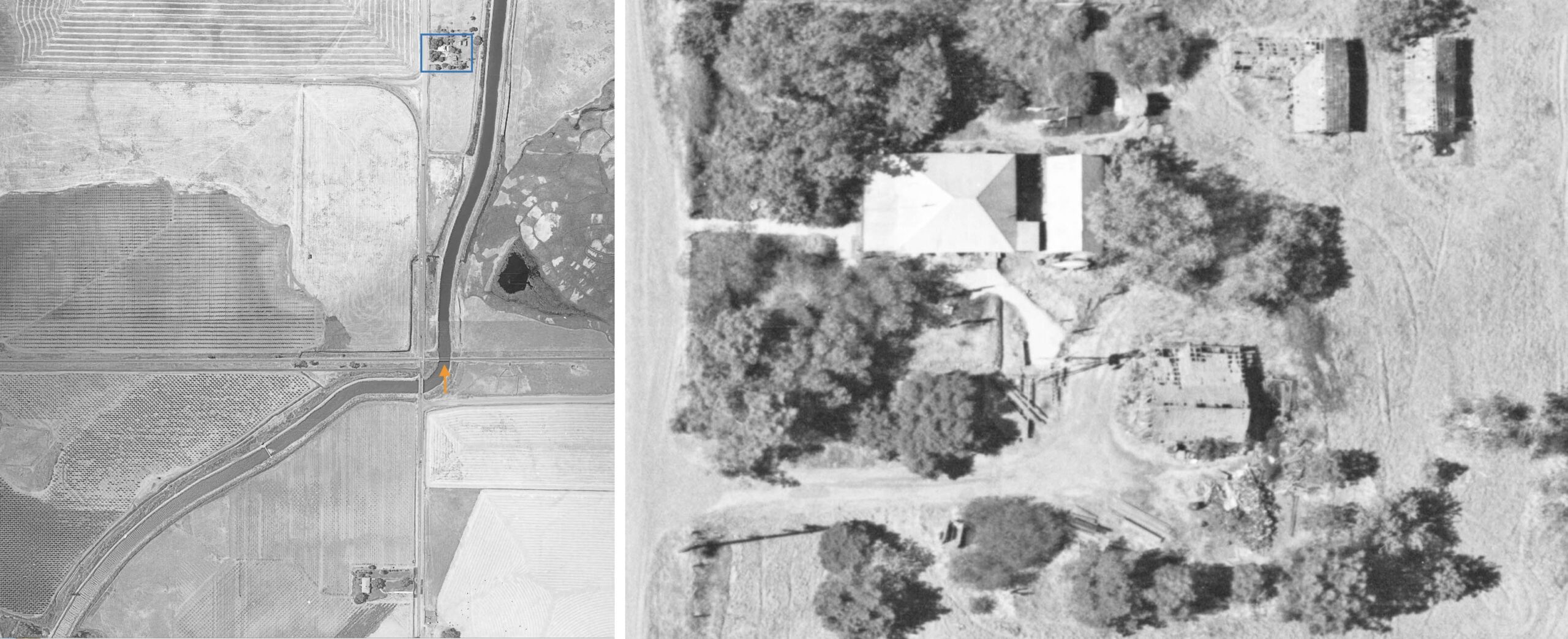
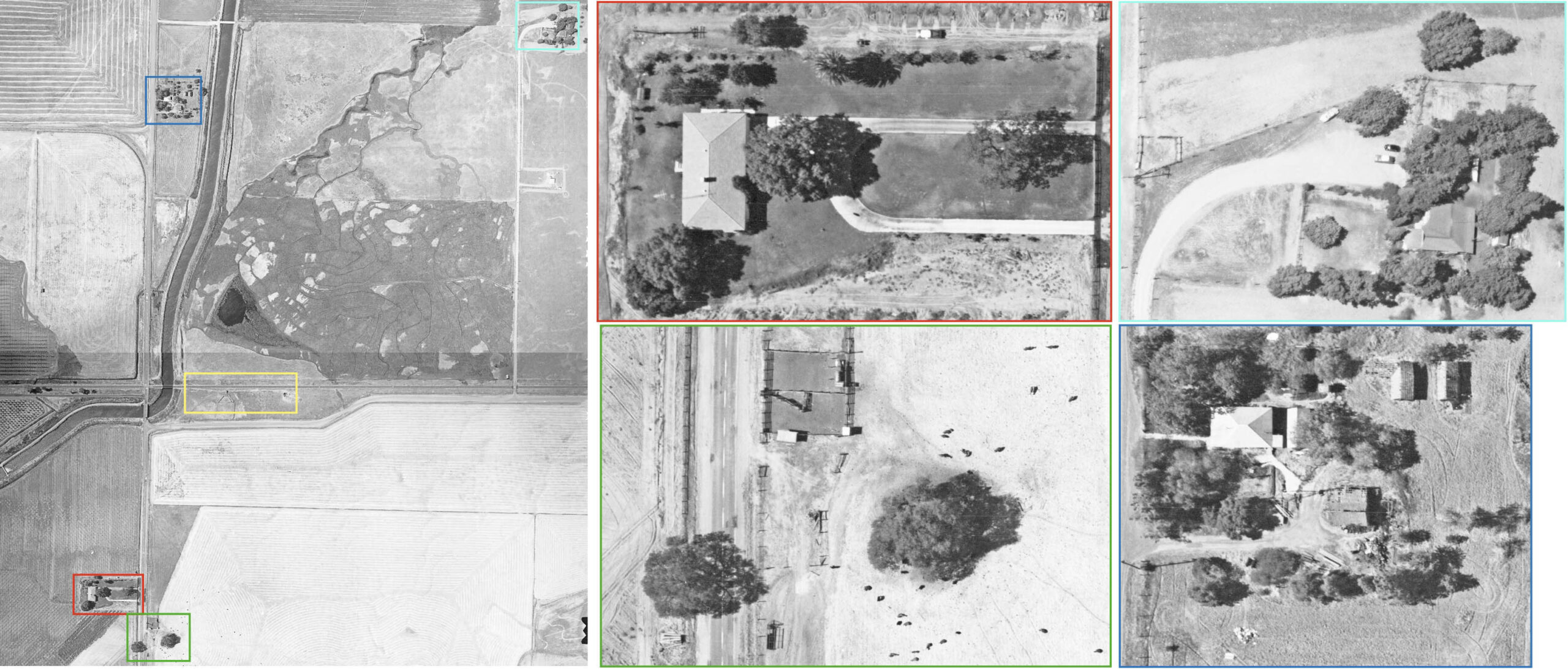
Further north, the property boxed in blue is shown for reference as it was already detailed in L323-74. The other two properties, one boxed in turquoise, and one boxed in two colors, red for the house, and green for the ranch, are involved in raising cattle. The area boxed in yellow is shown in the next image that follows.
L323-78-Courtesy California Department of Water Resources, 4_68, top, 5_88, bottom, r and l, (Image 19 of 45)
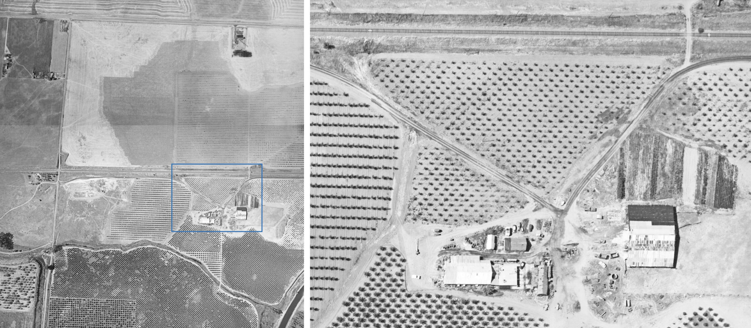
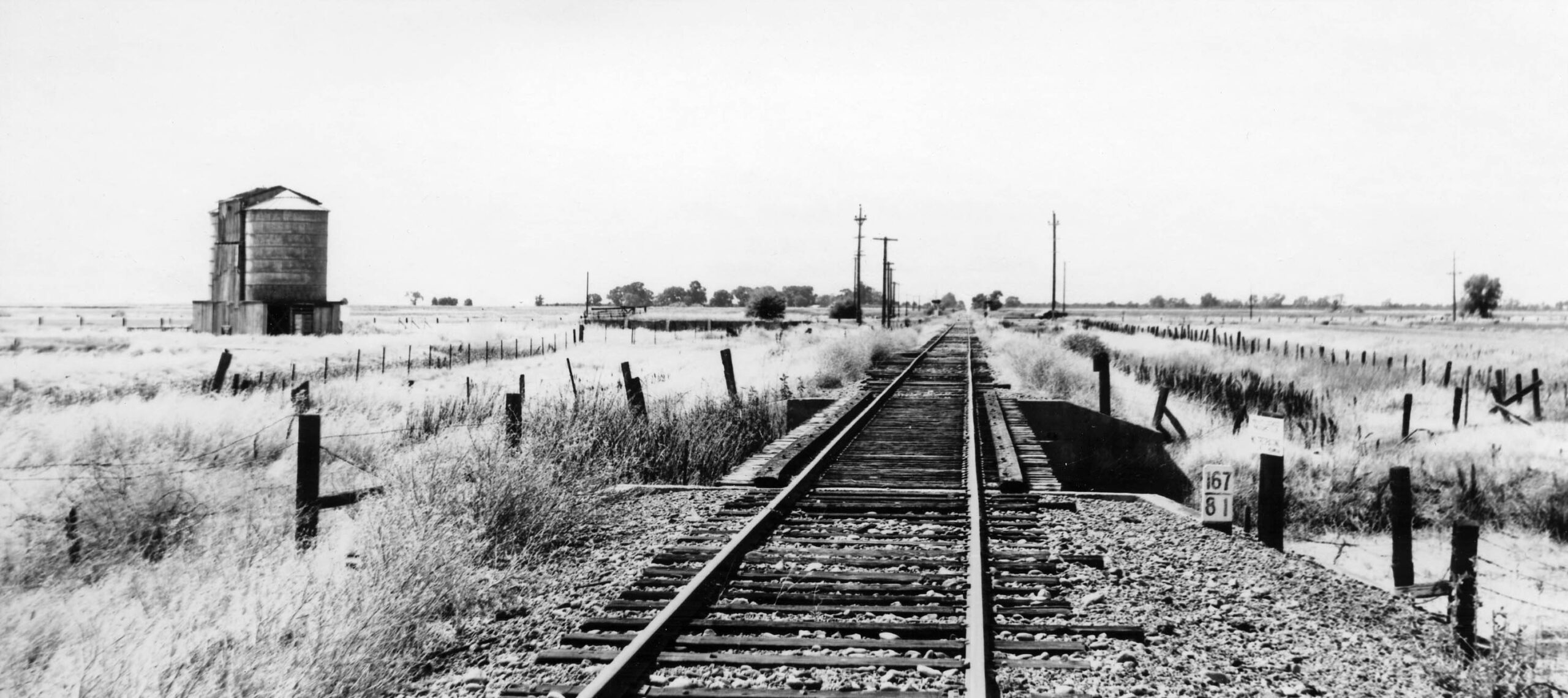
This is a view of the SN mainline and team track at Lorraine. It should be of no surprise given the agricultural slant of the surrounding ranches that the image shows a device used to load cattle onto trains. Given the proximity to Larkin Rd., the canal, and the roads leading into it, the site may have been used for something else, but that has not been uncovered. It is not surprising that the site was called Feather River by the NE in 1914, because the road and canal would have allowed products to flow to this site. Lorraine revealed!
L323-80-Courtesy California Department of Water Resources, 5_88, (Image 20 of 45)
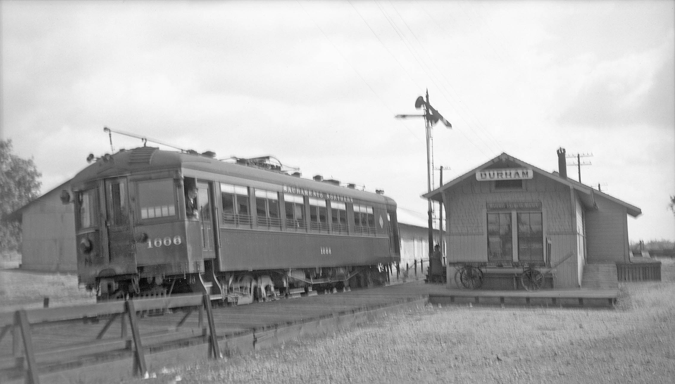
On to the Durham-Oroville Jct. Branch line, here looked at mostly during its operation as part of the SN mainline circa 1940. Our train awaits at Durham, the conductor indicating SN 1006 as train no. 7 is about to leave. South view, Sept. 1940. Jeff Asay noted that the depot is still an open train order office, but the semaphore indicates no orders for this train.That would mean any train approaching the station is required to stop and receive any orders that may be waiting for them from a dispatcher.
L323-85-Vernon Sappers Collection, Courtesy BAERA, WEstern Railway Museum Archives, , 137202sn, (Image 21 of 45)
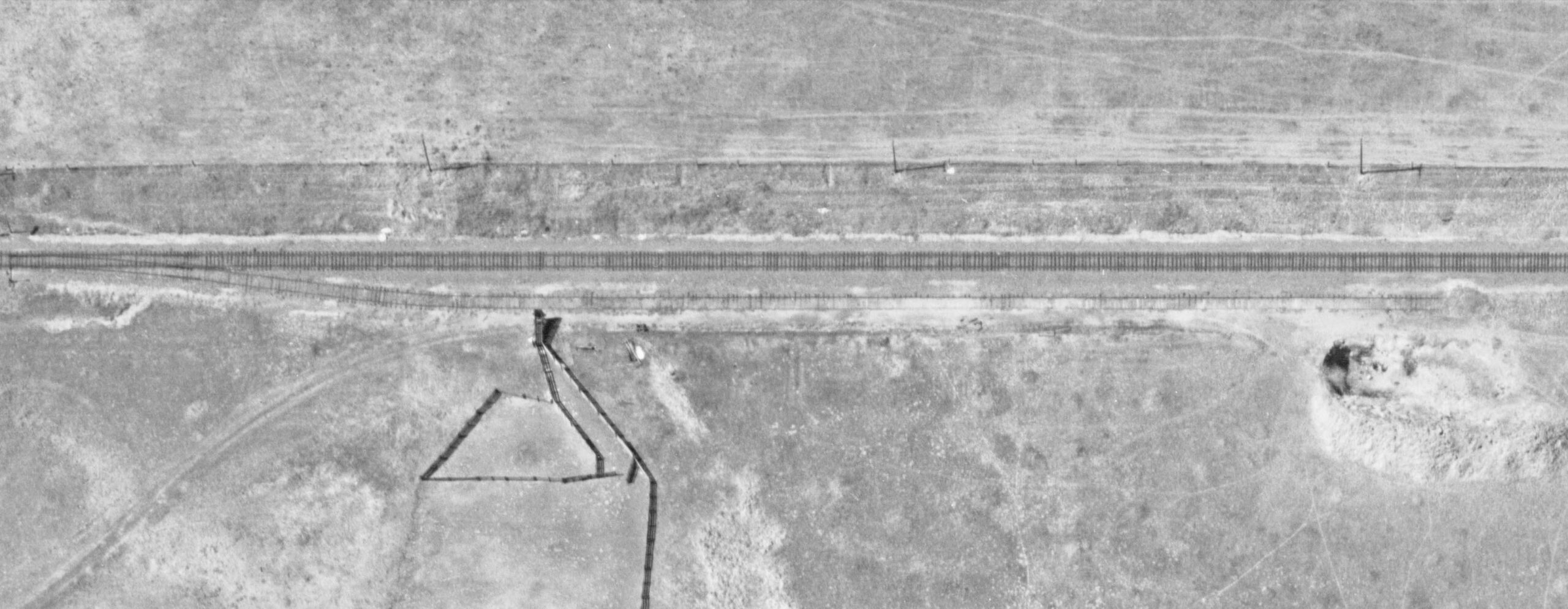
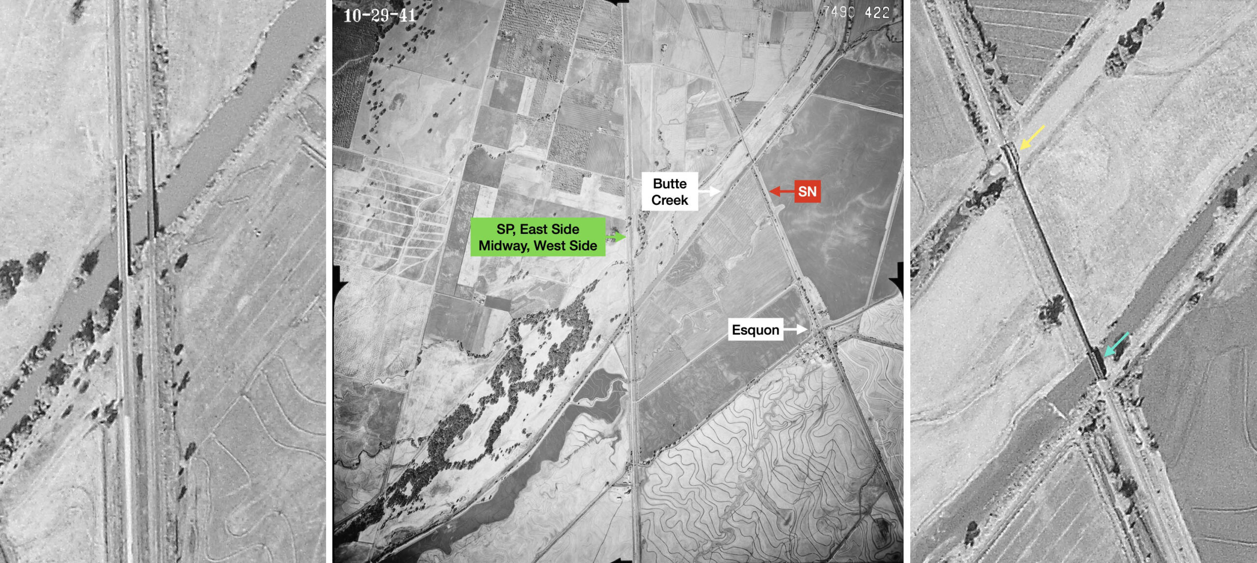
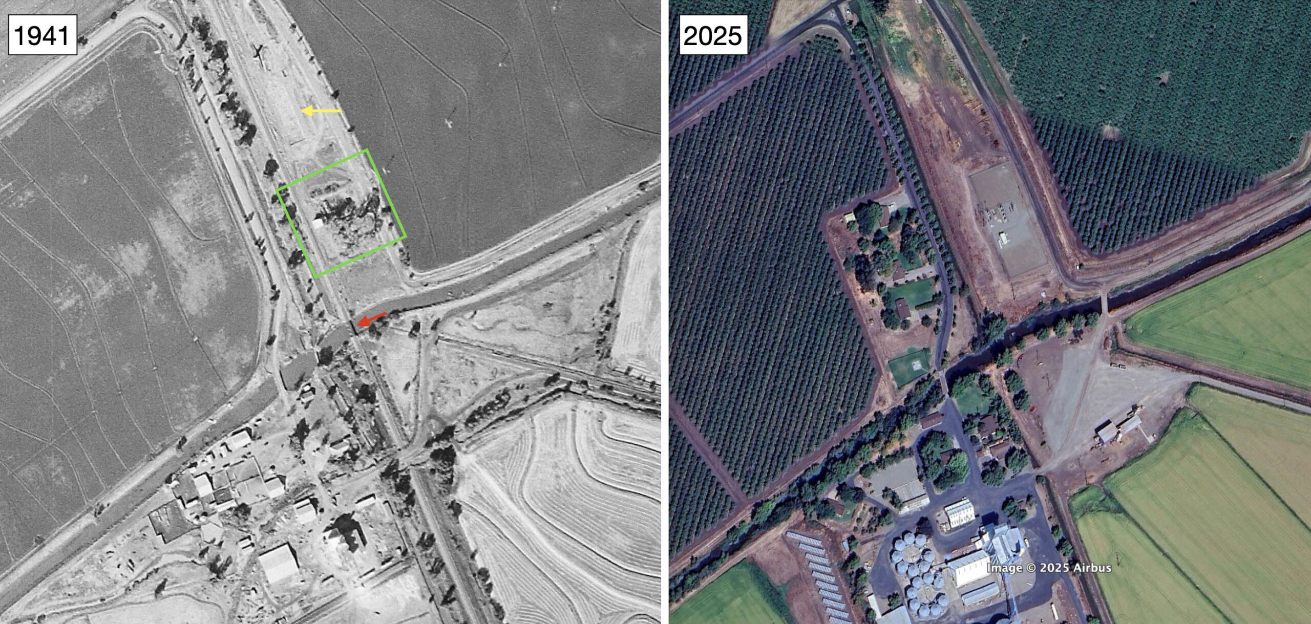
Heading South, the train gently swings to the southeast through open farmland heading to the first significant landmark, Butte Creek, followed by the first stop, Esquon. The aerial from 1941, center, has all the key elements labeled. Details of the Midway and SP crossings are shown on the left, the same for the SN on the right. In the case of the SN, the long trestle had a tall guardrail in the northern crossing of a road, yellow arrow, and a steel overpass with no guardrail to the south, turquoise arrow.
L323-90-c-7490_422, Courtesy of UCSB Library Geospatial Collection, (Image 22 of 45)
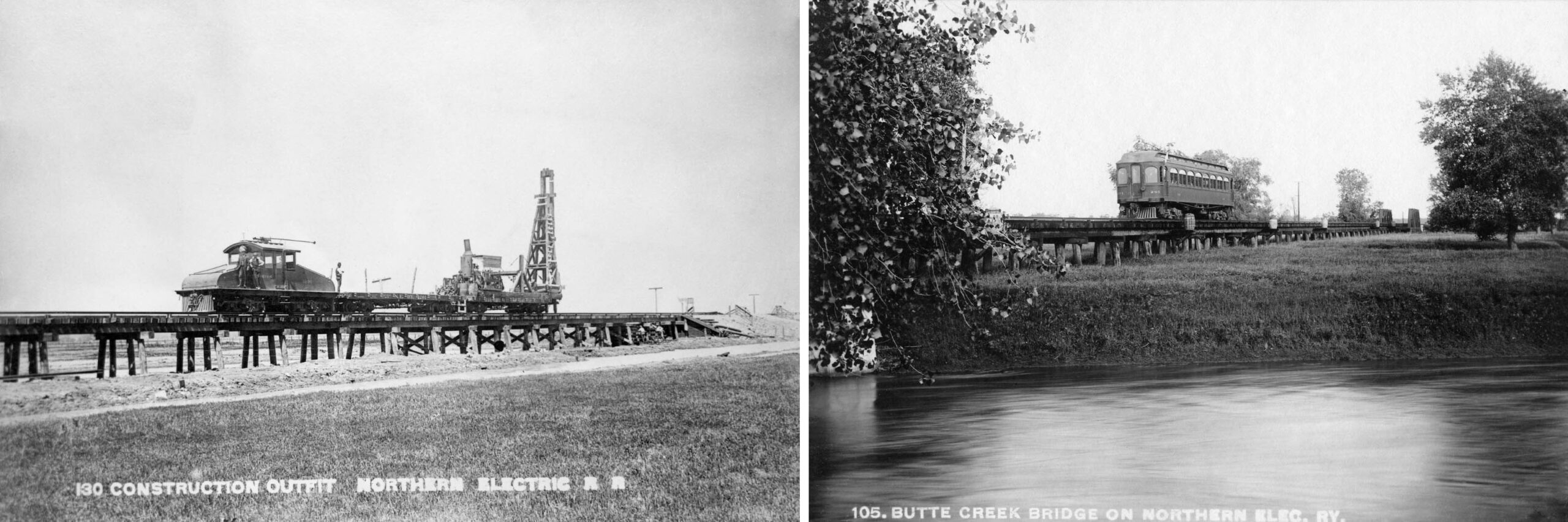
On the left, a view of the construction of the trestle with a work train led by NE 1000. On the right, a circa 1910 northwest view of SN 201. Assignment of the direction of the view in the latter is based on the crossing with the guardrails seen in the distance.
L323-95-NE Photos, Courtesy BAERA, Western Railway Museum Archives, 64638sn, l, 241208, r, (Image 23 of 45)
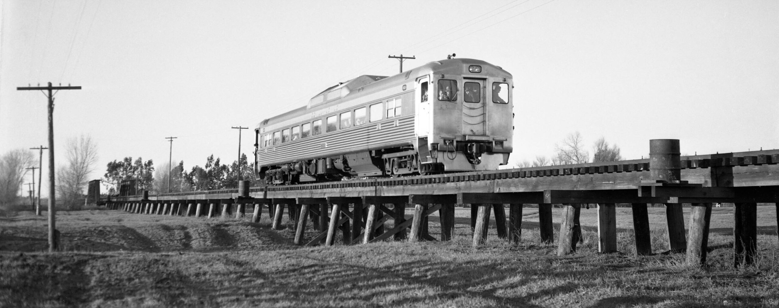
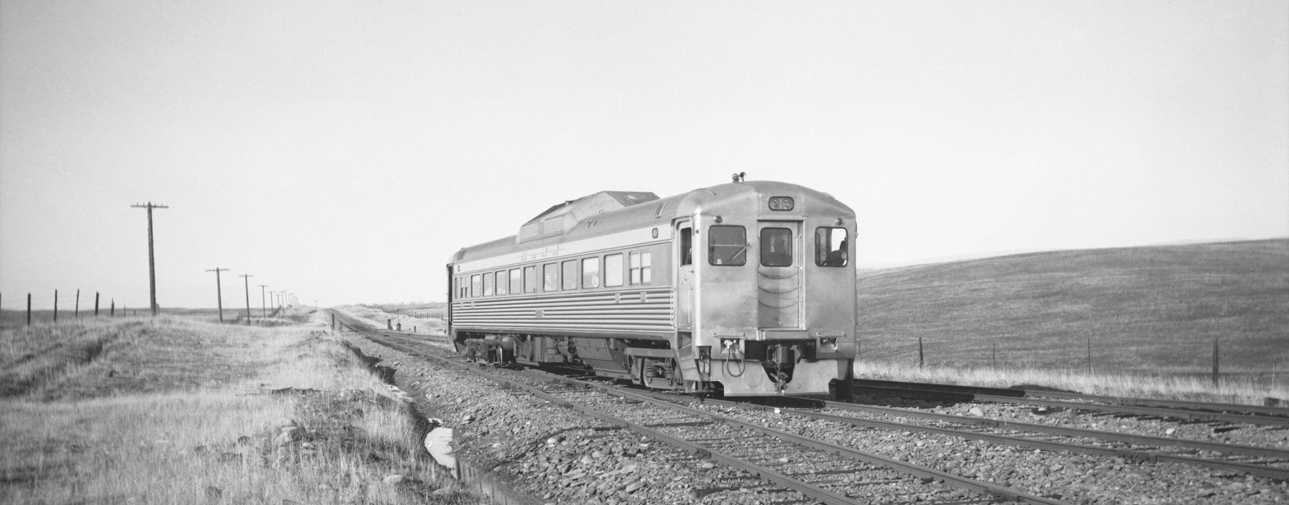
Moving forward chronologically, no images of the trestle could be found until the Bay Area Electric Railroad Association excursion of the North End on Jan. 29, 1950 with Budd RDC-1 Railcar Demonstrator. Shown here, a north view of RDC-1 midway across the trestle, the position of the guardrails at the north end.
L323-100-Arthur Lloyd Photo, Courtesy BAERA, Western Railway Museum Archives, 126046sn, (Image 24 of 45)
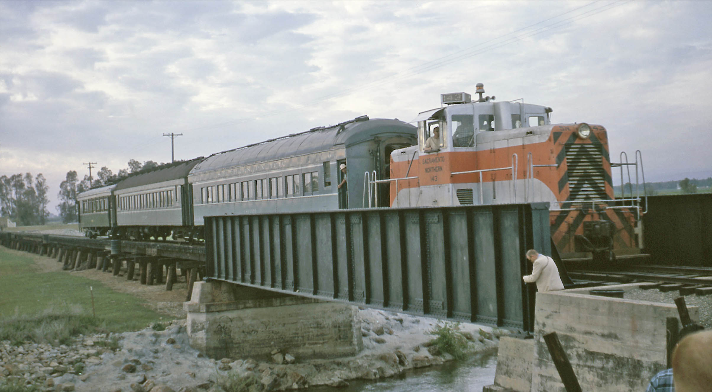
An excursion with SN 143, SP 1208, SP 1975, and SN 1005 Apr. 14, 1962 shows a train that has reached the southern overpass of the actual creek, north view.
L323-105-Robert Ford Photo, Moreau Coll., Courtesy BAERA, Western Railway Museum Archives, 241210sn, (Image 25 of 45)
Back to the excursion of Jan. 29, 1950, RDC-1 is also traveling south, but here the image is taken with a view toward the northwest.
L323-110-Courtesy BAERA, Western Railway Museum Archives, 90011sn, (Image 26 of 45)
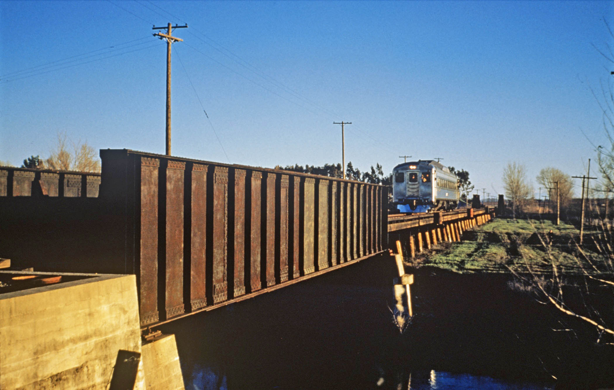
The trestle has been cleared as seen in a northwest view from the rear of SN 1005 heading south from the Apr. 14, 1962 excursion.
L323-115-Richard Kampa Photo, Courtesy BAERA, Western Railway Museum Archives, 138477sn, (Image 27 of 45)
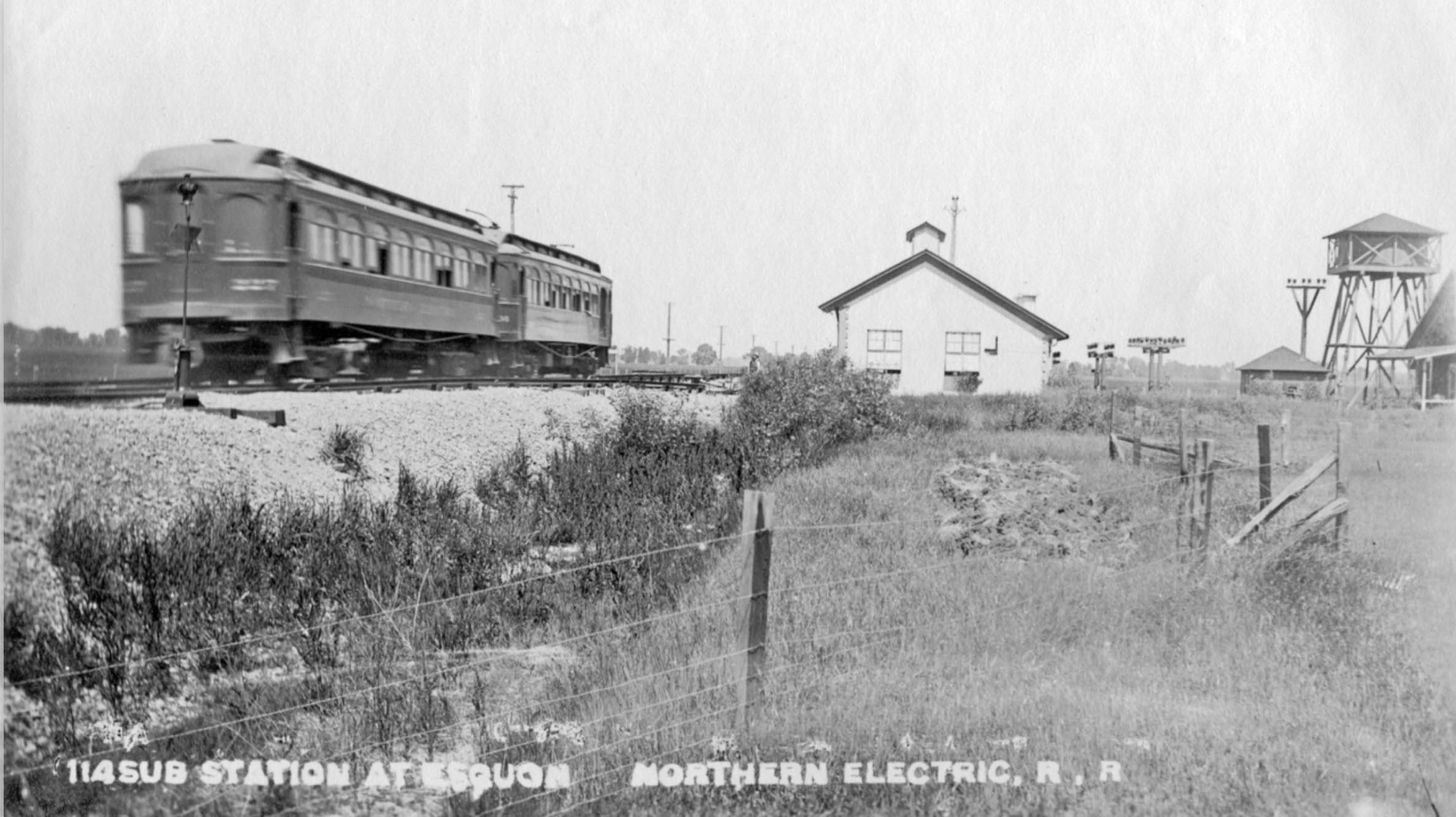
Ahead is the first stop at Esquon, this southeast view showing the automatic substation, water tower, siding with switch in the distance, and beyond that, a change in the roadbed indicating a small trestle.
L323-120-Howard Wolfe Photo, Courtesy BAERA, Western Railway Museum Archives, 232728sn, (Image 28 of 45)
A comparison of 1941 to 2025 of the station area, boxed in green, and the creek crossing, red arrow. The yellow arrow points to an outline of a building that will be discussed shortly. For a summary of the history of the area and the current Rancho Esquon, click here.
L323-125-c-7490_422, Courtesy of UCSB Library Geospatial Collection, (Image 29 of 45)
A NE promotional image ca. 1909 viewed to the northwest with NE 227 and trailer shows the substation and tower. No images were encountered that showed a depot or shelter.
L323-130-NE Photo, Louis L. Stein Collection, Courtesy BAERA, Western Railway Museum Archives, 16430ne, (Image 30 of 45)
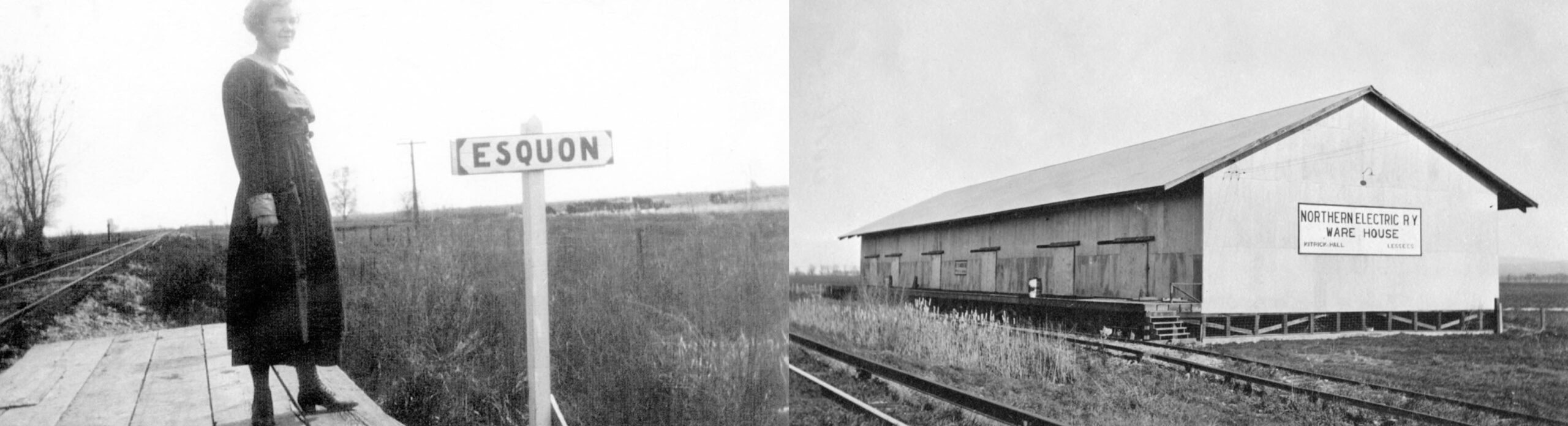
The image on the right of local Ruth Hazen in 1918 documents there was at a minimum a platform at the station at one time. The warehouse on the right most likely accounts for the outline of the building in the 1941 aerial shown in L323-125.
L323-135-Courtesy BAERA, Western Railway Museum Archives, 29480, l, 16431ne, r, (Image 31 of 45)
The substation that became obsolete when electric service ended at the end of 1946 is shown here in Jan. 1963, left. A northwest view of the right-of-way showing the elongated railroad ties used for the siding is shown on the right from 1968 while the branch was in service. The electric facility seen here remains in 2015.
L323-140-Courtesy BAERA, Western Railway Museum Archives, 182172sn, l, 29480, r, (Image 32 of 45)
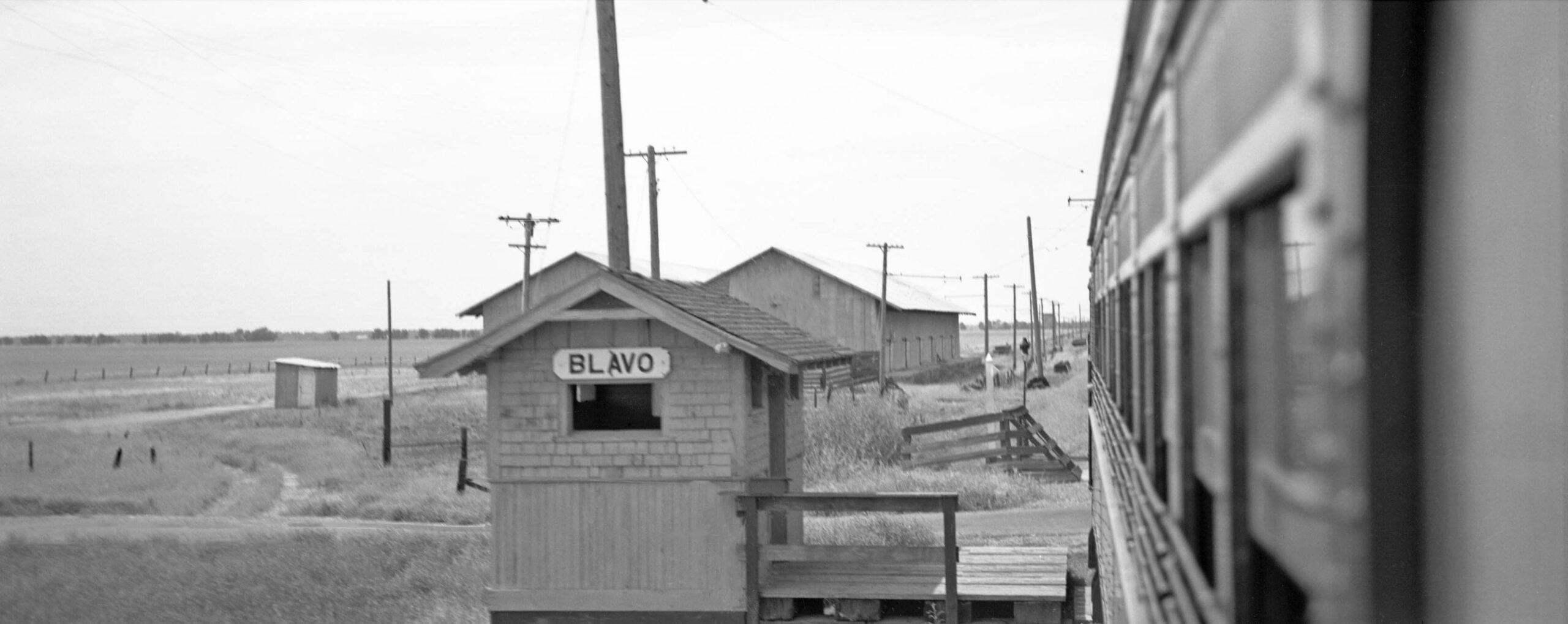
The train continues on for a short stop at Blavo. This north view shows the small shelter to the south of the grade crossing, at that time the Nelson Blavo Rd. A warehouse with a relatively long spur leading to it from the north with overhead wire is north of the crossing. Recall from earlier in the presentation at L323-30 that the warehouse here was used for general storage by the Butte County Warehouse Co. ca. 1957 with a capacity of eight freight cars.
L323-145-Howard Wolfe Photo, Courtesy BAERA, Western Railway Museum Archives, 232729sn, (Image 33 of 45)
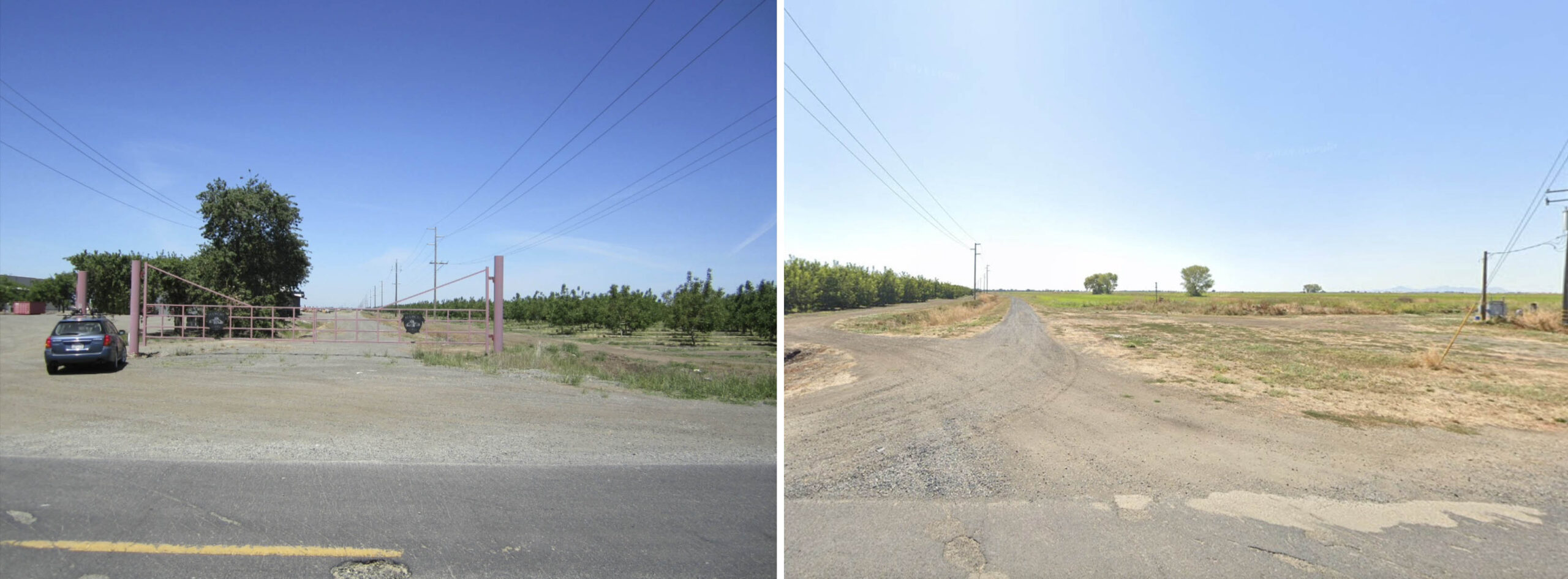
A northwest view from 2018, left, and a southeast view from 2024, right, of the abandoned SN right-of-way at Blavo are shown here. On the left, a warehouse, barely visible to right of the trees, is placed north of the road as part of Bianchi Farms. No remains of the shelter are seen, right, but the slight curve from railway days can still be appreciated. It appears as of 2025, all the land to the west of the former route out to Midway Rd. is for sale and is configured for rice farming. The land to the east contains orchards, the relationship to this business is not known.
L323-150-Stuart Swiedler Photo, r, Google Maps Photo, l, (Image 34 of 45)
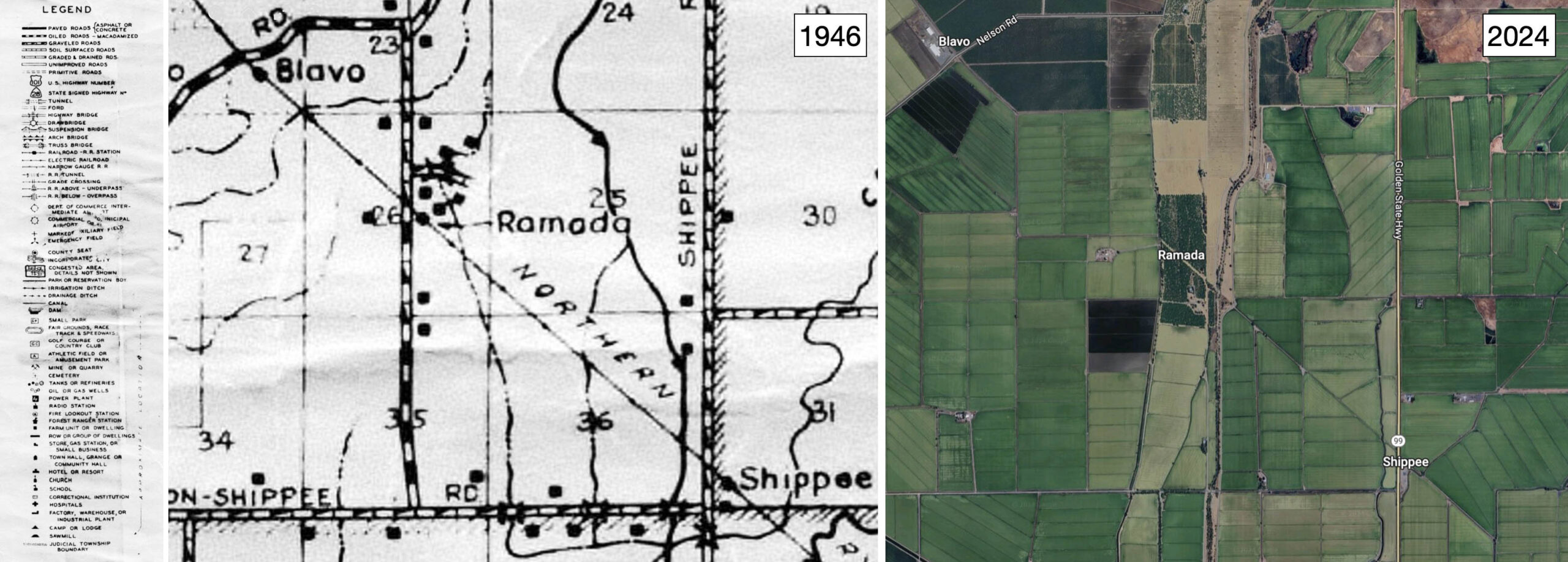
Aerial coverage of Blavo and Ramada before 1985 was not available, but this detail from the map of Butte County from 1946 employed previously, left, shows the stations at Blavo, Ramada and Shippe being located to the east of the major road crossings, this already shown for Blavo. Ref: Full Title: Map of Butte County, California. Compiled and published by Thomas Bros. ; copyright by Harry Freese. G4363 B8 1946 T6. Deposited at Meriam Library, California State University, Chico.
L323-153-Courtesy Meriam Library, California State University, Chico, ca_2044, l, Google Maps, r, (Image 35 of 45)
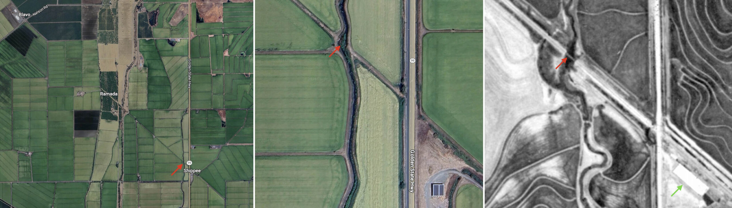
The portion between Blavo and Shippe from 2024 is repeated here, left. The central panel shows a feeder of Cottonwood Creek that crossed under the SN tracks at Shippe, red arrow. An aerial view that included Shippe from 1952 was found, and a detail from it, right, shows there was a trestle there, red arrow. On the east side of Shippe Rd., now Highway 99, there was a warehouse-like structure, green arrow, consistent with the location of a station shown in the map in the previous panel.
L323-155-Courtesy Google Maps, l and c, aax-1952_7k-6, Courtesy of UCSB Library Geospatial Collection, (Image 36 of 45)
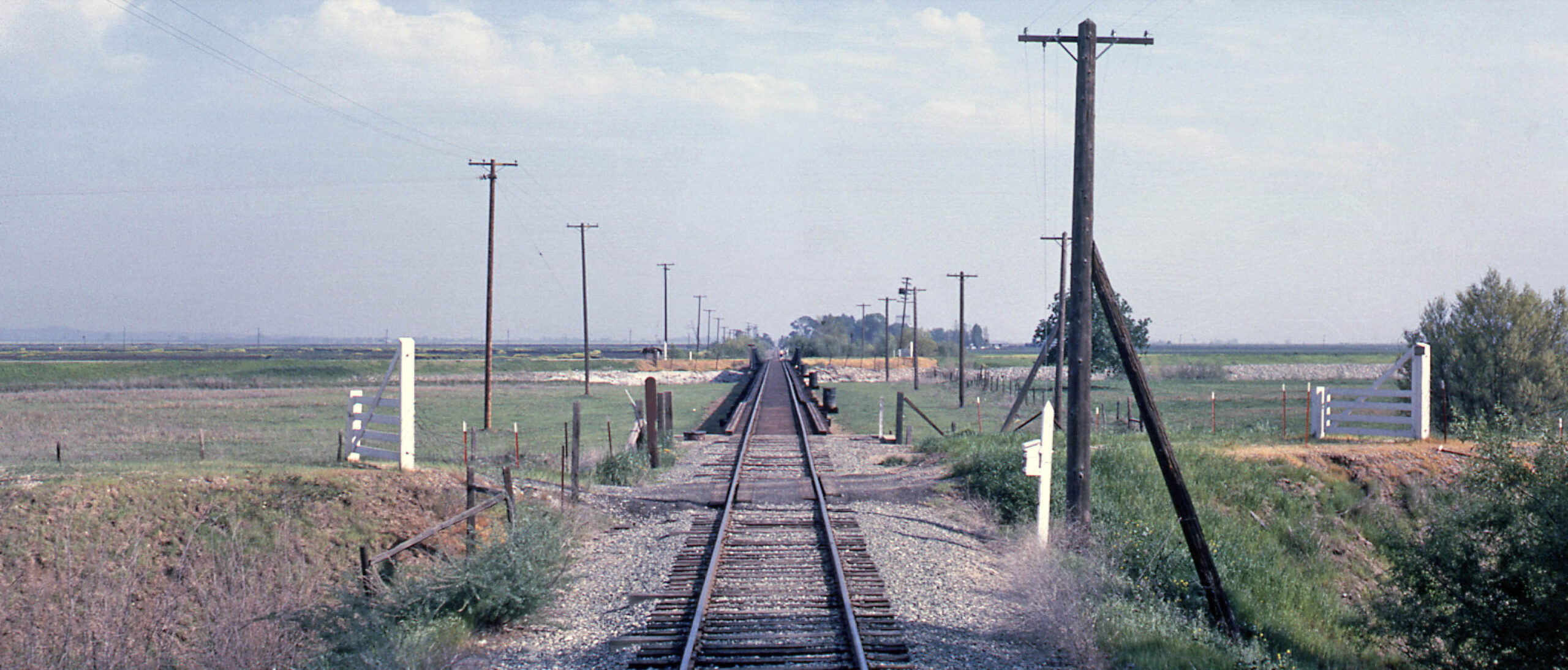
Kirby M. Harris either took or collected photographs of the branch line in June of 1971, just a short time before the line was officially abandoned on Aug. 18, 1971. This northwest view of Ramada dated June 27, 1971, presumably from still unimproved Gage Rd., is still preserved in 2025 by the line of electric tower lines cutting through the planted fields. In 2025, this crossing is covered over with vegetation save the road.
L323-160-Kirby M. Harris Collection, Courtesy BAERA, Western Railway Museum Archives, 121592sn, (Image 37 of 45)
After Ramada came Shippee, this northwest view from June 27, 1971 taken just east of the trestle over the feeder to Cottonwood Creek discussed previously. The power lines crossed west of here, followed by some telephone lines heading northwest. In 2025, this section has no poles of any type.
L323-165-Kirby M. Harris Collection, Courtesy BAERA, Western Railway Museum Archives, 121594sn, (Image 38 of 45)
Our train continues on, back to the excursion of Jan. 29, 1950 with Budd RDC-1 Railcar Demonstrator, here approaching the curve into Oroville Jct. Whether it is 1940, 1950 or 2025, the surrounding scene hasn’t changed an iota.
L323-170-Sappers Collection, Courtesy BAERA, Western Railway Museum Archives, 106485sn, (Image 39 of 45)
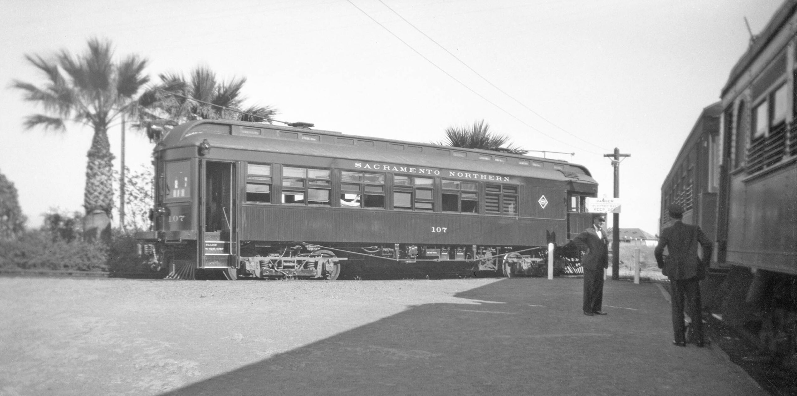
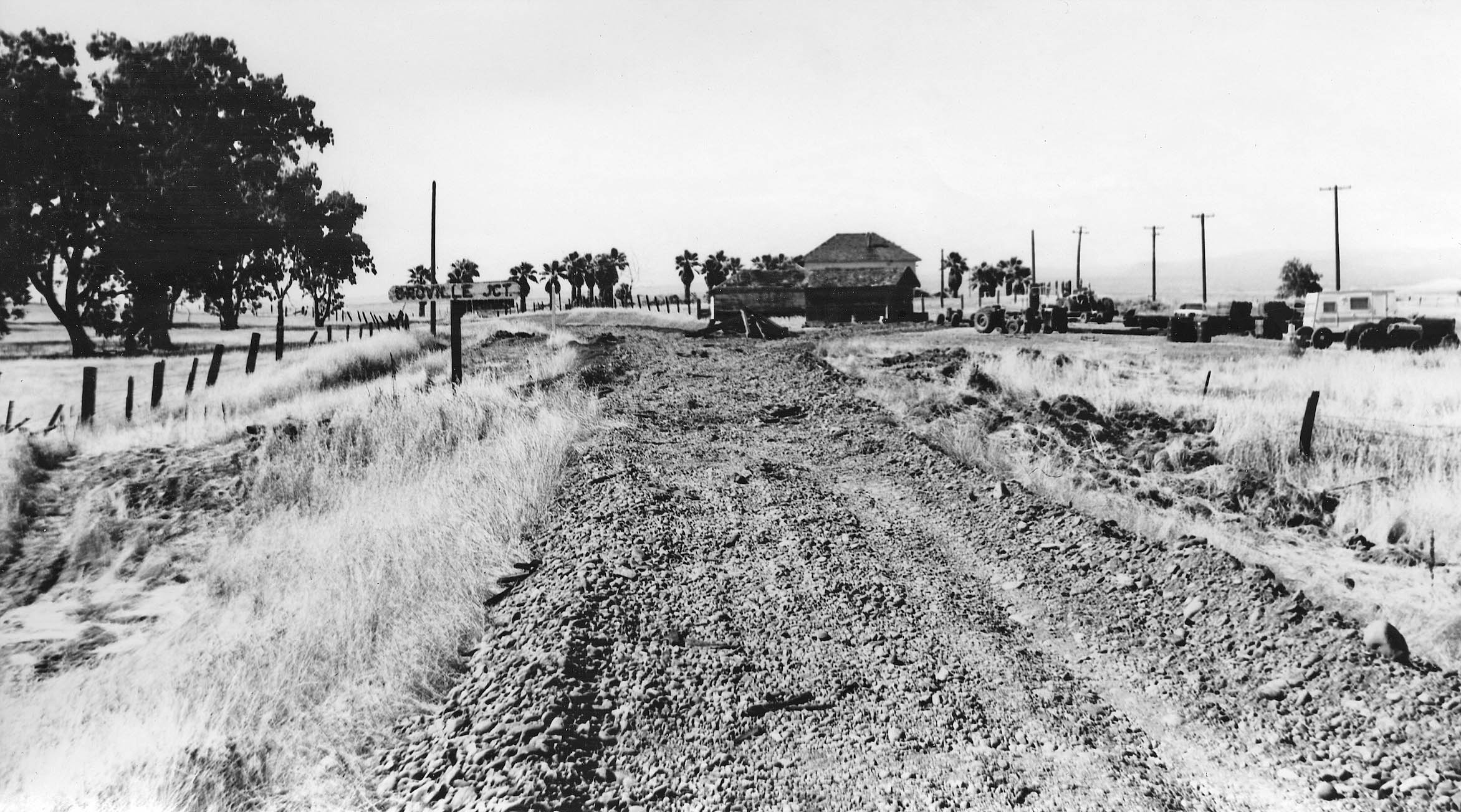
Finally the train has pulled into the station at Oroville Jct., formerly called Tres Vias. The conductor from SN 107 comes over for a chat, his train for the branch line to Oroville. The presence of SN 107 confirms the date of this southeast view to 1937 before the flood that December took out the branch line as a passenger carrier. Freights would still use this Oroville Jct., but passenger trains on the mainline would stop about one mile south as shown previously in this presentation.
L323-175-Tom Gray Collection, Courtesy BAERA, Western Railway Museum Archives, 161811sn, (Image 40 of 45)
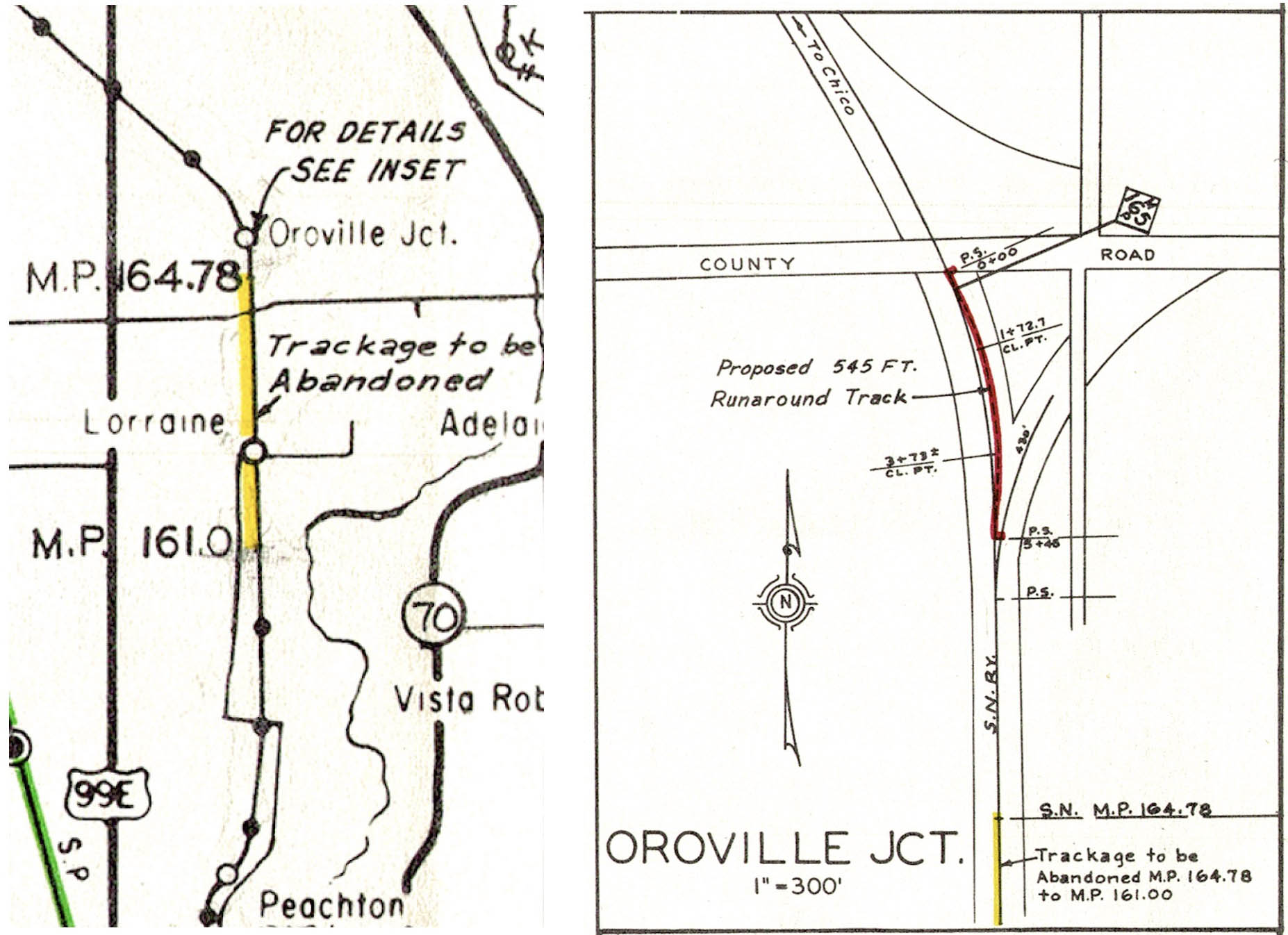
The plans shown in L323-10 from Mar. 29, 1966 show the branch line being formed by removing track, left, and placing a runaround track at the Jct. No images or documents to show that these changes were actually completed have been found.
L323-180-Courtesy BAERA, Western Railway Museum Archives, 39461, (Image 41 of 45)
Ted Wurm might have been the only one credited with an image that survived until 2025 showing what it looked like facing north from the Oro Dam Blvd. West overpass towards Oroville Jct. with SN 127 and rear trailer 223. Here the date is Oct. 27, 1940, the last Sunday of passenger service on the North End.
L323-185-Ted Wurm Photo, Courtesy BAERA, Western Railway Museum Archives, 33410sn, (Image 42 of 45)
To follow, three more unique images of the final days of the track on the Durham-Oroville Jct. Branch. First, track removal northwest of Oroville Jct., approximately at the curve near Nelson Ave. where Hereford cow breeder Lambert Ranch would soon takeover and still resides in 2025. This southeast view toward the Jct. was taken on June 19, 1971. Note the sign in the lower right corner …
L323-190-Kirby M. Harris Collection, , Courtesy BAERA, Western Railway Museum Archives, 121599sn, (Image 43 of 45)
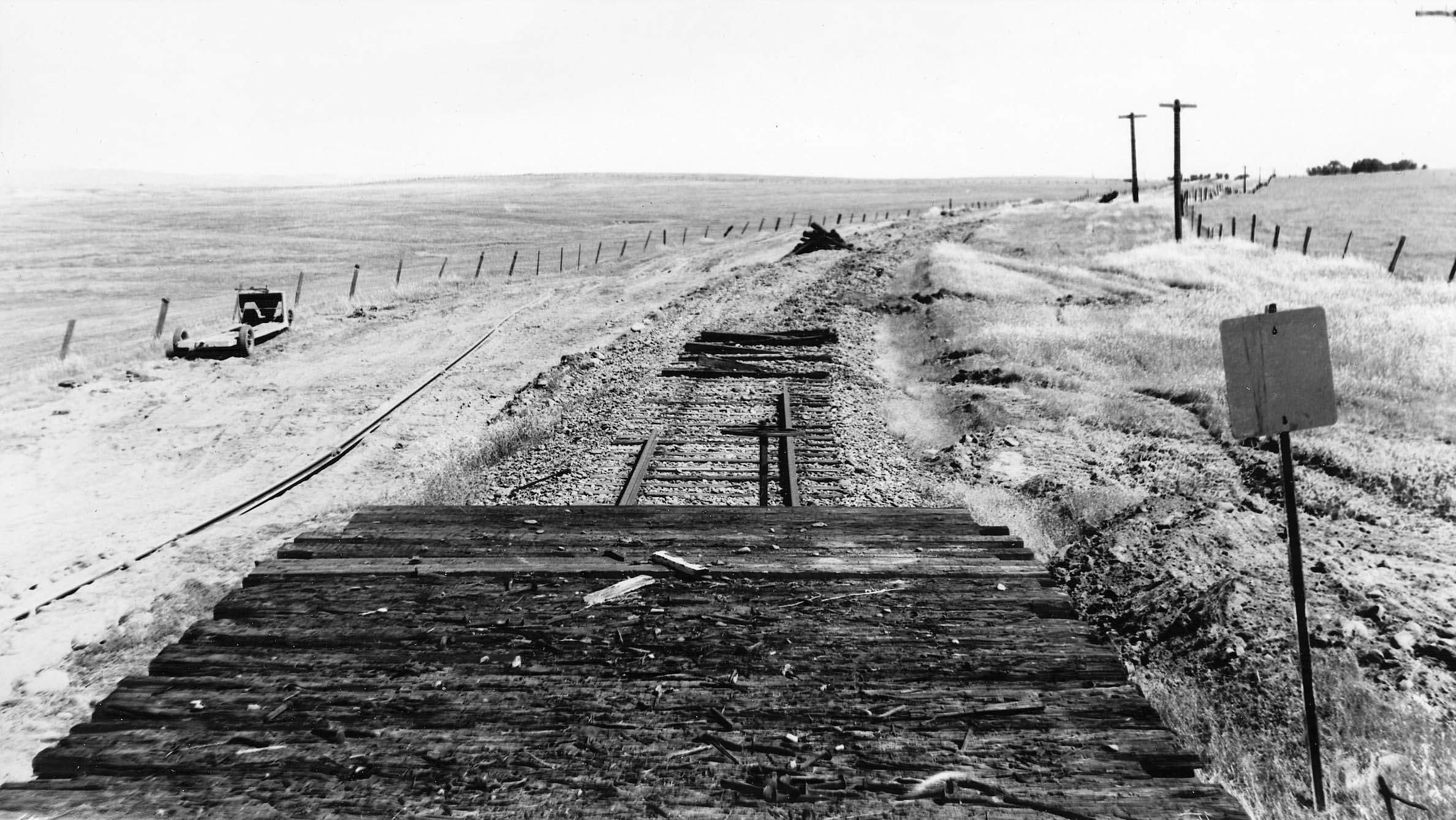
… turn 180 degrees, and see the view heading northwest away from Oroville Jct., and the equipment used to remove track on June 19, 1971. And, yes, track was being removed prior to the official day of abandonment. One can only imagine the last day freight service ceased, another piece of documentation to search for in the files.
L323-195-Kirby M. Harris Collection, , Courtesy BAERA, Western Railway Museum Archives, , 121597sn, (Image 44 of 45)
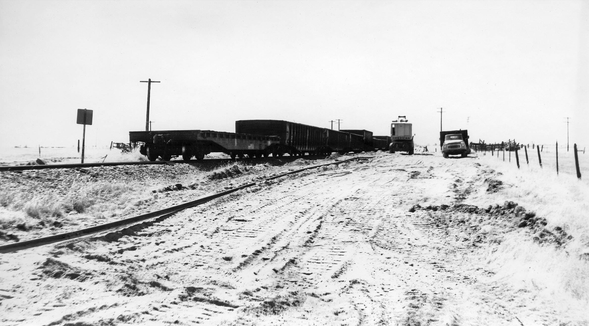
As expected, the track has been recently removed from Oroville Jct. and just north of it in this north view from the same day, June 19, 1971. Next time, to conclude with a review of the Live Oak-Peachton Branch. Appreciation to the folks at the California Dept. of Water Resources for reviewing their aerial files and providing the images. Thanks to Jeff Asay for reviewing the material and providing comments, corrections and insight.
L323-200-Kirby M. Harris Collection, Courtesy BAERA, Western Railway Museum Archives, 121596sn, (Image 45 of 45)