Reconstructing the Key Central Car House Private Right of Ways – 1st. Ave. Place and 2nd Ave.
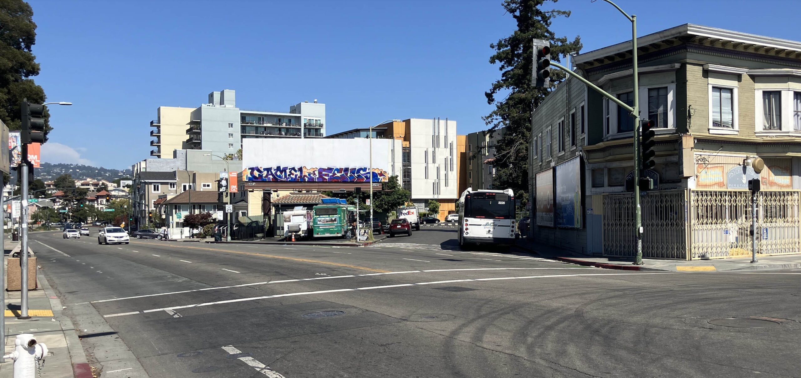
In 2025, a no. 40 AC Transit bus is seen at its stop at 1st. Ave. Pl. and International Boulevard in this northeast view up 1st. Ave. This bus will turn at E. 15th St. to head to East Oakland., (Image 1 of 36)

In the first half of the 20th century, 1st. Ave. Pl. was not a street for cars, but a private right-of-way used by Key System streetcars and A line interurbans. This path would lead them beyond E. 15th St. to the Key System Central Car House at Foothill Blvd. and 2nd Ave. The next two updates will attempt to reconstruct the route to the car house from the southwest and northeast, respectively, this update on the former.
L335-10-Courtesy BAERA, Western Railway Museum Archives, 166747ks, (Image 2 of 36)
The area to be reviewed over the next two updates are included in these aerials that have been rotated counterclockwise, from 1937, when the right-of-ways were used for streetcars and trains, and 2024, when used for autos and buses. An annotated version follows.
L335-15-Harrison Ryker Photo V5-142, Courtesy California Department of Transportation, l, and Google Earth, r, (Image 3 of 36)
From the southwest, the private right-of-way was situated between 1st Ave. and 2nd Ave. and Foothill Blvd. (E. 16th St.), red line. From the northwest there were two paths, the first along the abandoned right-of-way that is 3rd. Ave. between Park Blvd. and E. 18th St, green line, and a second short one connecting the car house to E. 18th St., yellow line. Looking more closely at the aerial from 2024, the southwest route has been built on between E. 15th and E. 16th Sts., white arrows, and the car house yard is now the shopping center with Lucky, turquoise arrow.
L335-20-Harrison Ryker Photo V5-142, Courtesy California Department of Transportation, l, and Google Earth, r, (Image 4 of 36)
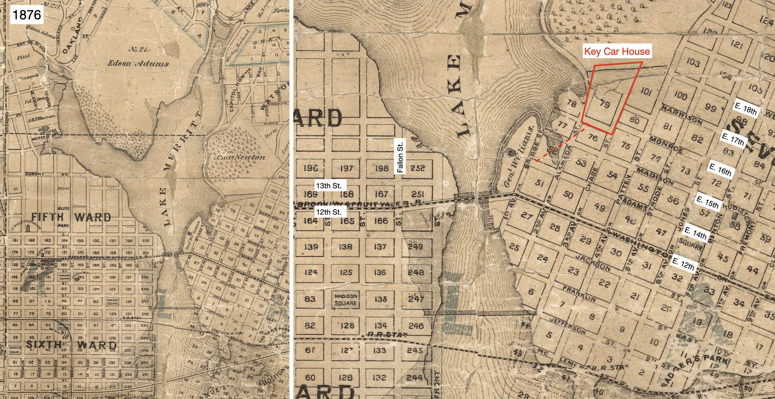
Now to focus in on the right-of-way beginning at 1st Ave. Back to 1876, the map shows the land eventually used for the right-of-way and car house were originally under water. Ref: Map of Oakland, Alameda and Vicinity, M. G. King, Author-Publisher
L335-25-Courtesy David Rumsey Map Collection, David Rumsey Map Center, Stanford Libraries, (Image 5 of 36)
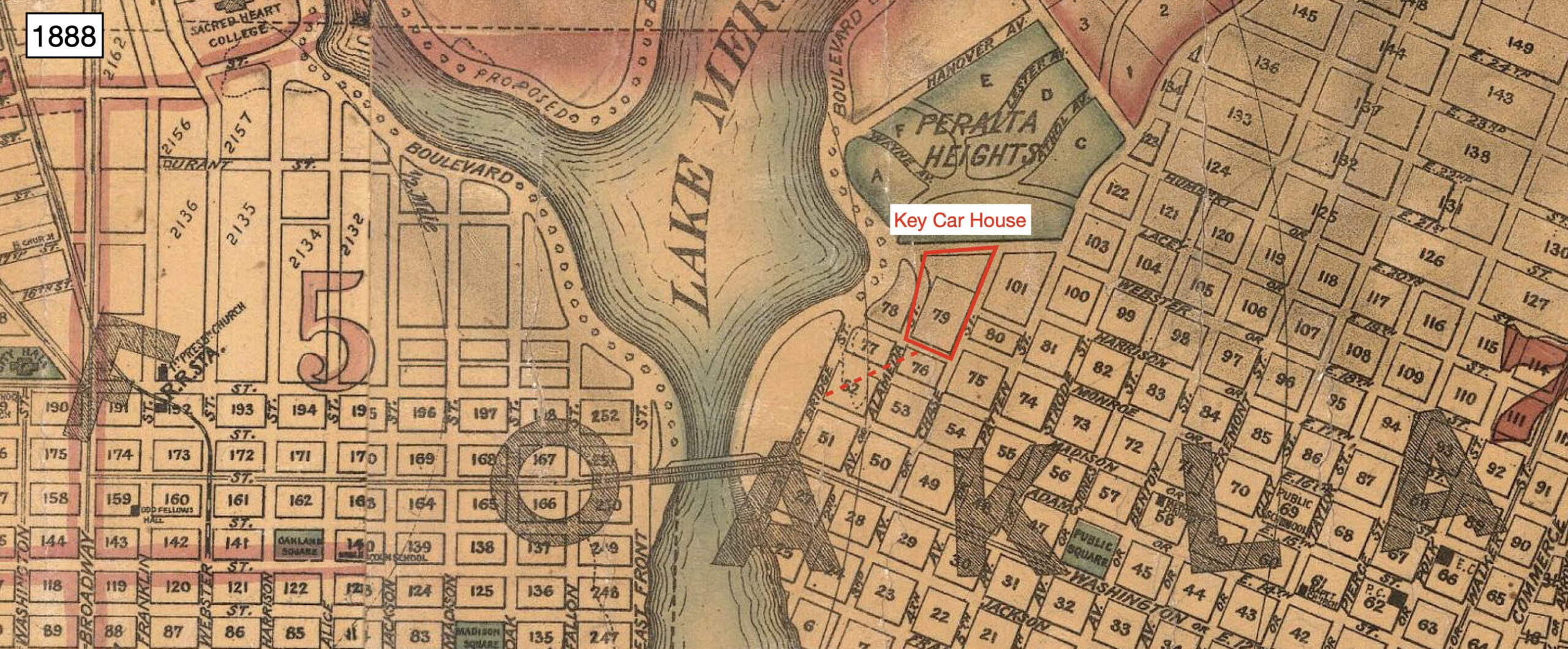
By 1888, landfill was in place allowing this section to be included in the street grid of the time. Ref: Map City of Oakland and Surroundings, J.C. Henkenius, Author, Woodward, Gamble, Publisher
L335-30-Courtesy David Rumsey Map Collection, David Rumsey Map Center, Stanford Libraries, (Image 6 of 36)
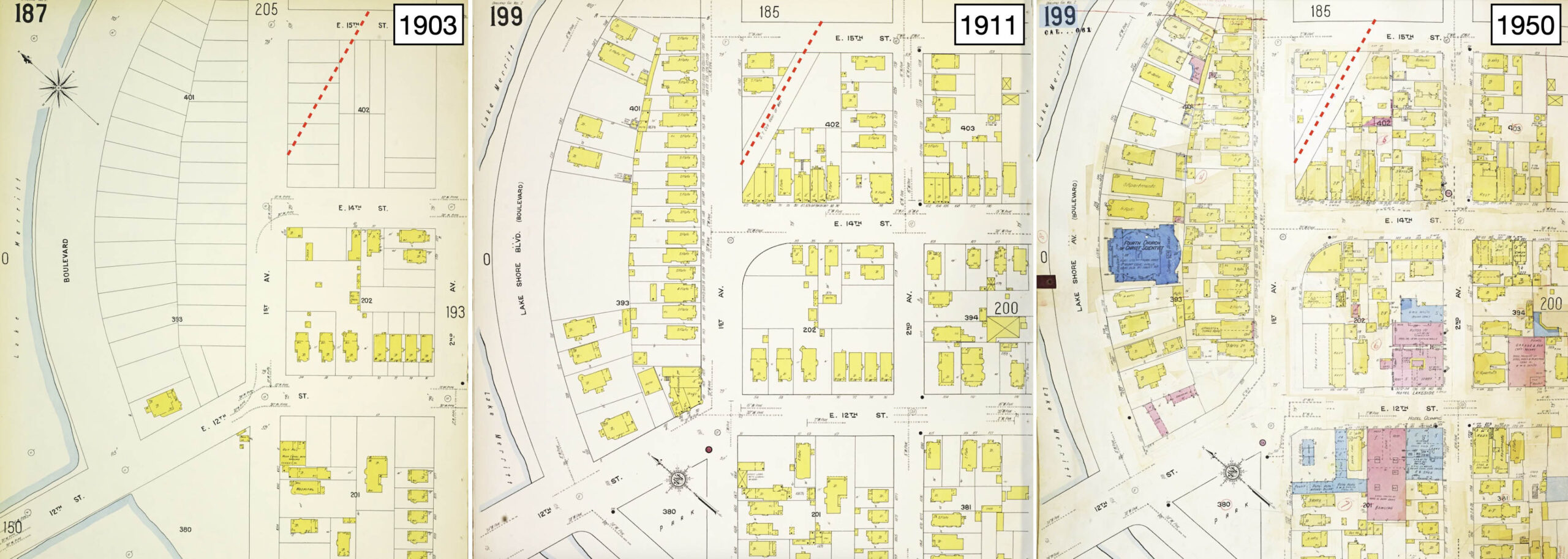
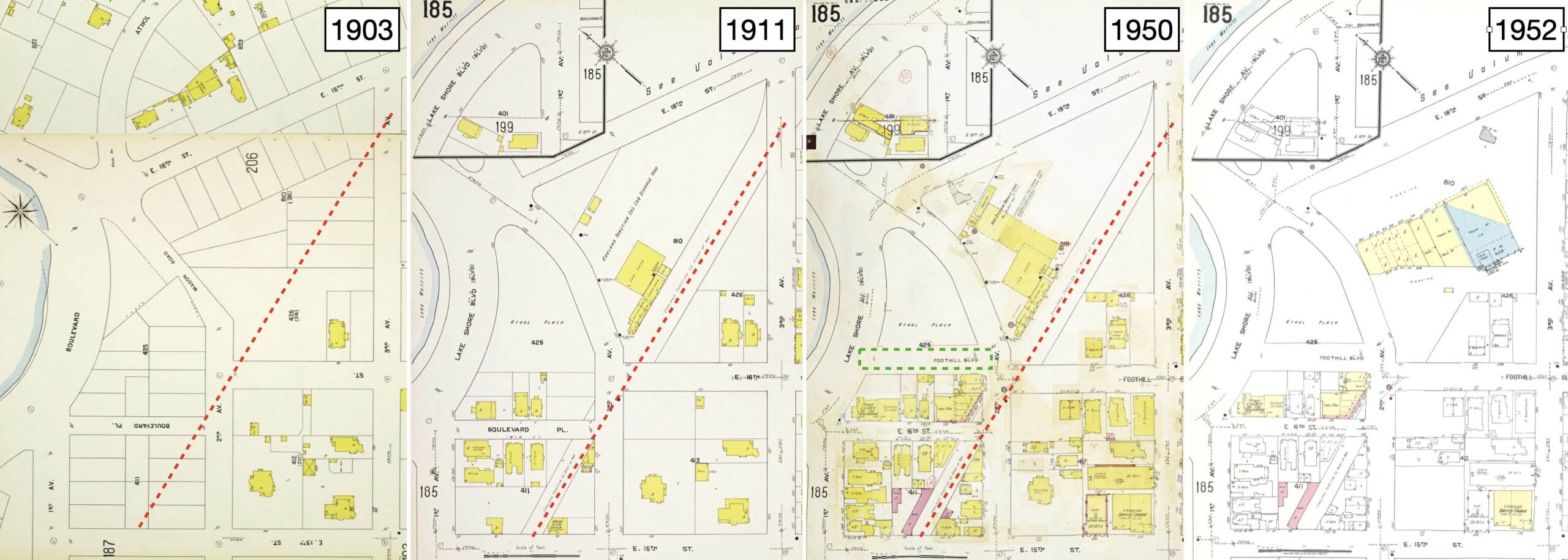
Borax Smith’s Oakland Traction Co. built the Central (Second Ave.) Car House (Station) or Central Division in 1905, and opened it for business on Mar. 3, 1906 according to Vernon Sappers’ “Key System Streetcars”, Signature Press, 2007. The Sanborn maps shown here reveal that the first block of the right-of-way to E. 15th St. did not remove any existing buildings, left, and that the area had already began to grow around the path pre-WWI, center, probably contributed to by the earthquake of 1906. Two additions were made on the east flank by 1950, right.
L335-35-Library of Congress, Geography and Map Division, Sanborn Maps Collection, Panel 187 from 1903 Vol 2, l, Panel 199 from 1911 Vol. 2, c, Panel 199 from 1911 - Nov 1950 Vol. 2 , r, (Image 7 of 36)
In contrast, the flanks of the right-of-way between E. 15th and 16th Sts. were mainly added to after WWI, center right. The boundaries of the car house are shown in the center left and center right panels, the number of structures having increased between 1911 until the facility was abandoned in late 1948, replaced by the shopping center by 1952, right. Sixteenth St. was renamed Foothill Blvd. by 1928 based on directory listings. An extra piece of Foothill Blvd., boxed in green, was added to connect it to Lakeshore Ave. The one block of Blvd. Pl. was renamed E. 16th St., that street discontinuous with the E. 16th St. that starts up at 23rd Ave.
L335-38-Library of Congress, Geography and Map Div., Sanborn Maps Coll., Panels 205-206 from 1903 Vol 2, l, 185 from 1911 Vol. 2, cl, 185 from 1911-Nov 1950 Vol. 2 , cr, 185 from 1911-1952 Vol. 2, r copy, (Image 8 of 36)
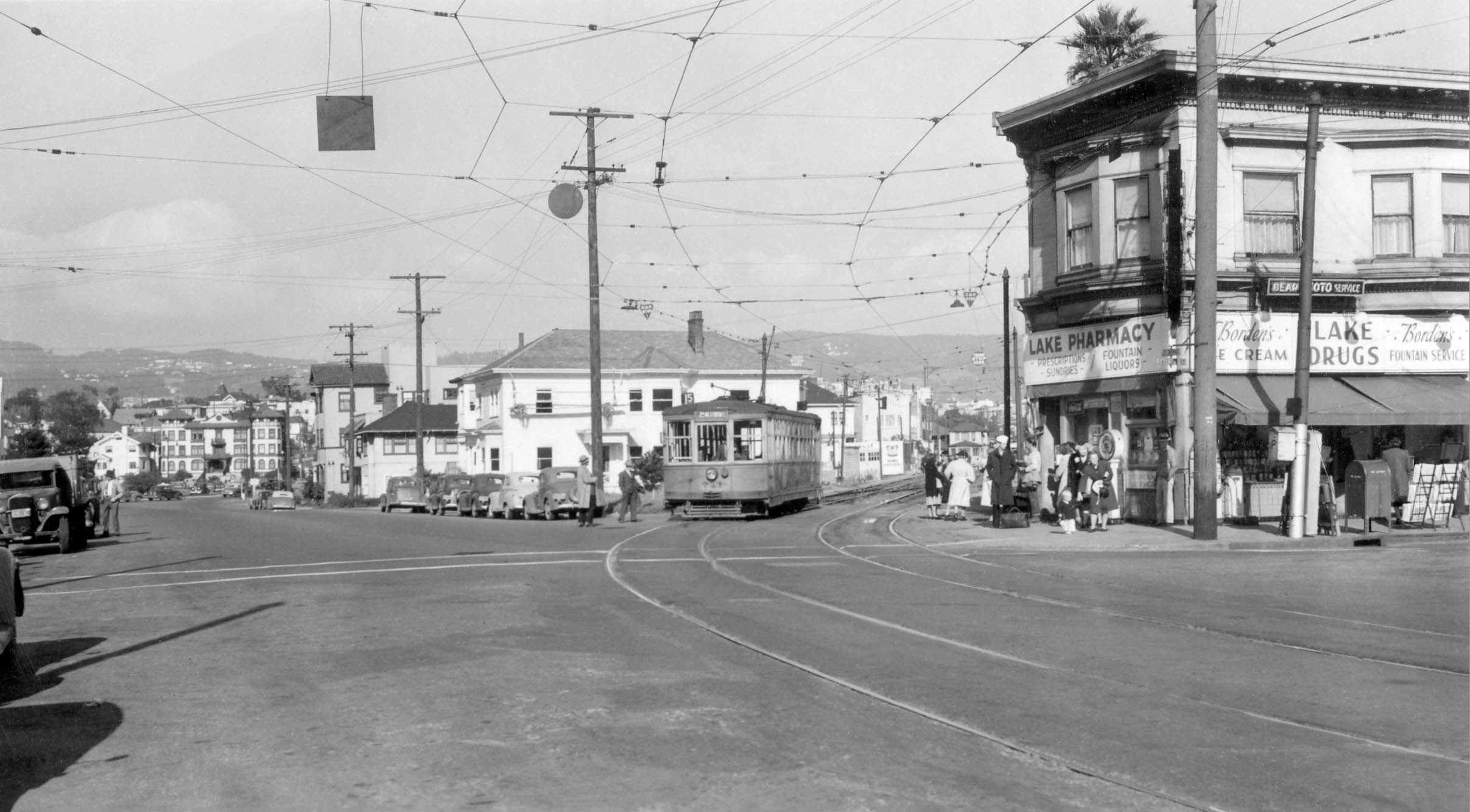
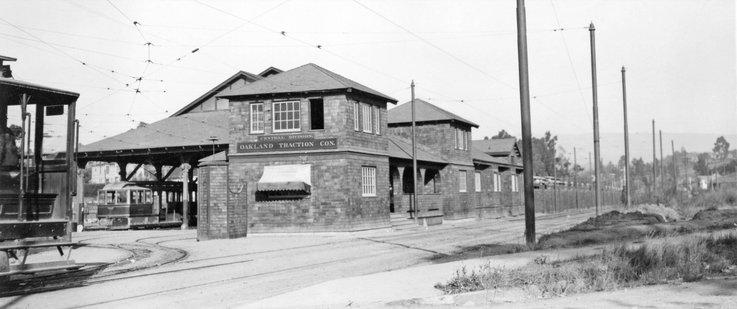
Sappers describes the car house as containing a shed, an office, stores and a machine shop as seen in this very early north view. There was a large yard to store rolling stock not in use. This is a ca. 1906 north view from the southwest entrance.
L335-40-Louis L. Stein Collection, Courtesy BAERA, Western Railway Museum Archives, (Image 9 of 36)
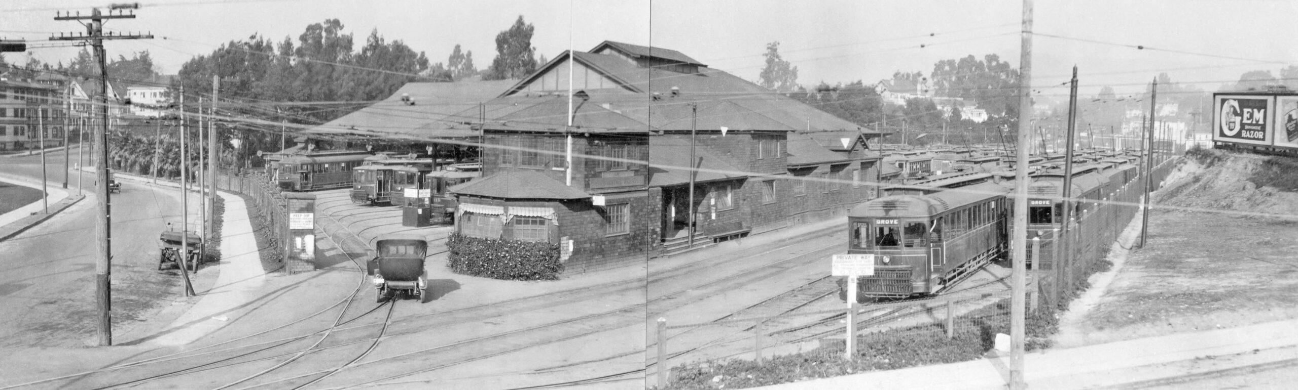
This diptych panorama of the Central Car House in Oct. 1919 is a north view from E. 16th St., Foothill Blvd. in 2025. The left portion of the combined image shows a view up 2nd Ave. to E. 18th St.
L335-45-Erle Hanson Collection, Courtesy BAERA, Western Railway Museum Archives, 130650ks, (Image 10 of 36)
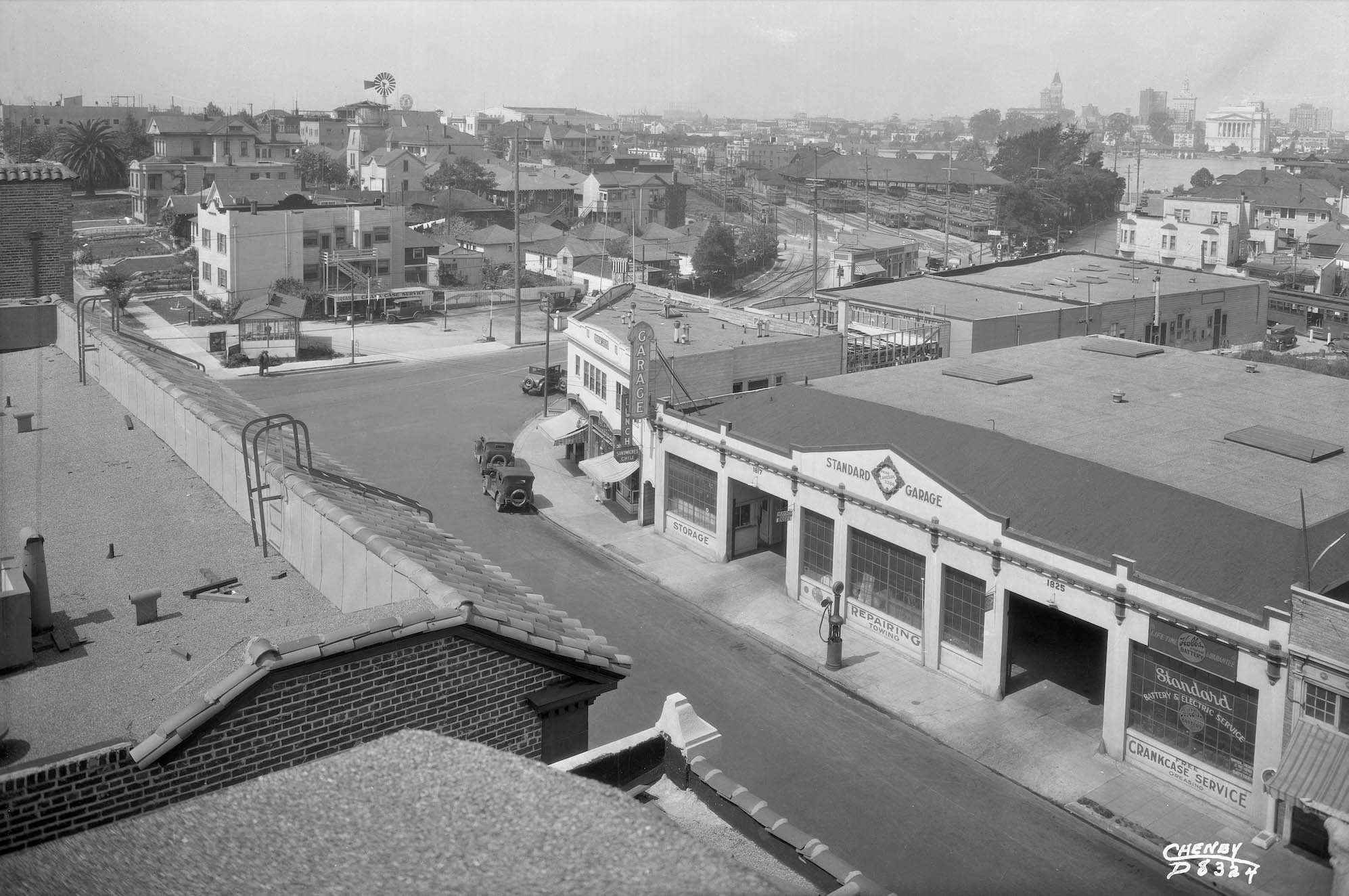
Ahead to ca. 1925, a west view with the car house and Oakland City skyline taken from the Parkway Theater at no. 1834 Park Blvd. between E. 18th and 19th Sts. The theater opened in 1925, the architect was Mark T. Jorgensen. The elongated building occupied by Standard Garage with the decorative cornice and triangular parapet, nos. 1815-1825 Park Blvd. (Permit no. 64150) dates to 1921. Next to it, the green colored building in 2025 that curves around this corner, also with a decorative cornice and parapet, dates to 1923 (Permit no. 76931.) Note the streetcar along the right edge.
L335-50-Cheney Photo D 8324, Sappers Collection, Courtesy BAERA, Western Railway Museum Archives, 45849ks, (Image 11 of 36)
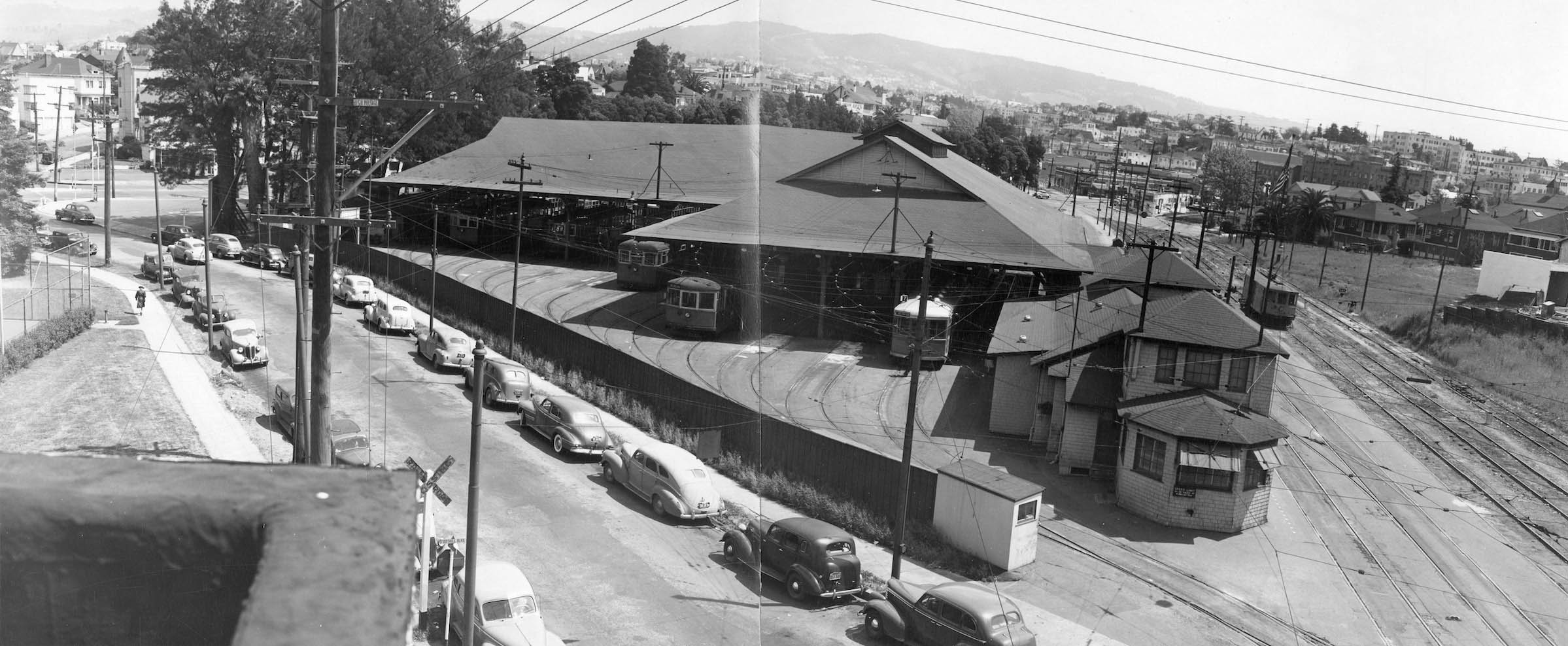
Finally, the pièce de résistance, a diptych taken in 1947 from the apartment across from the car house at no. 1615 2nd Ave. dating back to 1923 (Permit no. 76931.) The tracks along the car house heading to E. 18th St. will be the subject of the next update. Sappers notes that eleven streetcar lines were serviced by this facility. However, due to WWII and as the other car houses in the East Bay closed, there was constant shuffling of lines and their numbers in the 1940s. Since most of the images collected were taken during this period, many numbered lines will be seen.
L335-55-Commercial Studios, Photographers, RL Cohen Co, GL.9717, 116 Franklin St., Oakland, Courtesy BAERA, Western Railway Museum Archives, 161058ks, (Image 12 of 36)
Before reconstructing the right-of-way beginning at 1st Ave. and 1st Pl., a comparison of the 1937 aerial with one from 2022 is a reminder that the portion between E. 15th and E. 16th Sts. was erased when the Lakeside Senior Apartments was completed in 2015. All the structures boxed in red would be removed, left. Note, however, that the structures between 1st Ave.and E. 15th St. remain unchanged in 2025.
L335-60-Harrison Ryker Photo V5-142, Courtesy California Department of Transportation, l, and Google Earth, r, (Image 13 of 36)
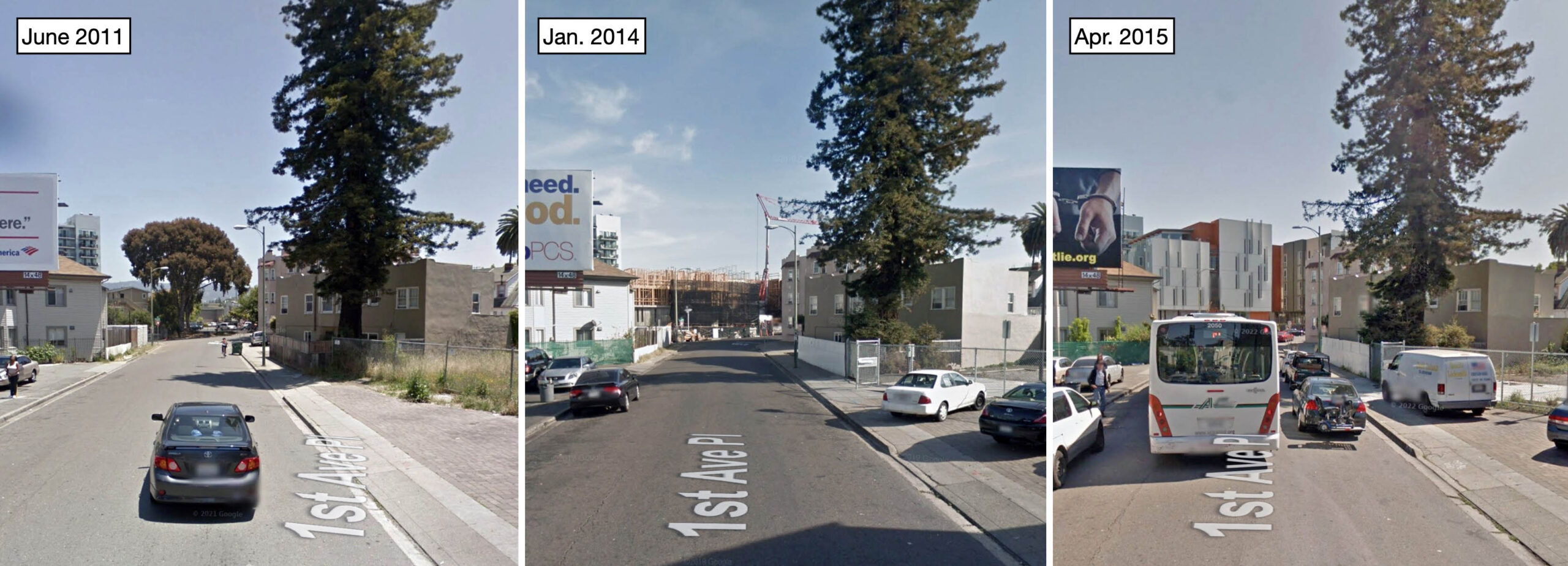
Northeast views up the right-of-way were archived on Google Maps, this set of three images confirming that the new housing structure was completed by Feb. 2015 at a cost of $33M as a co-partnered project between the landowner, Oakland Housing Authority, and Satellite Affordable Housing Associates (SAHA) with David Baker & Partners as architects, Roberts-Obayashi Corporation as contractor, and numerous sources of outside funding. The building is LEED Platinum certified and has won numerous architectural and housing awards. Residents include seniors with very low income and some previously homeless.
L335-65-Courtesy Google Maps, (Image 14 of 36)
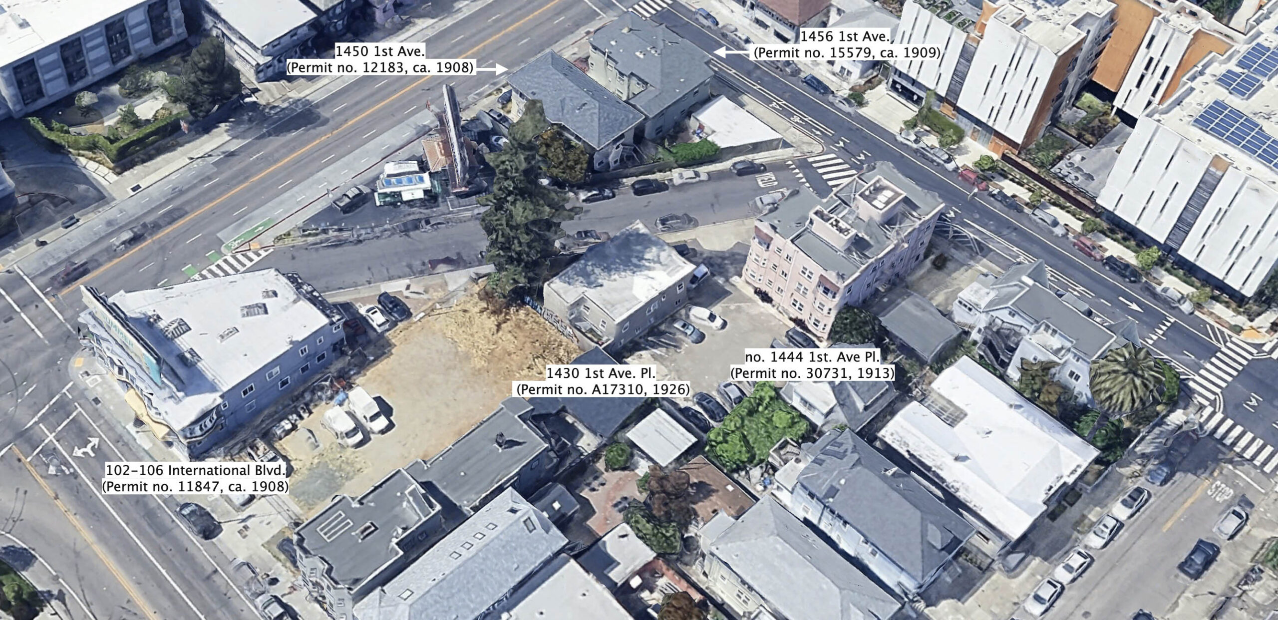
This north aerial view from 2025 of the right-of-way between 1st. Ave. and E. 15th St., named 1st Ave. Pl., shows the buildings that are landmarks for the images prior to 1950 to be presented next. Note the two private dwellings at nos. 1450 1st Ave and 1456 1st Ave. were built with the rear of the buildings facing the tracks. References to specific streetcar lines made in the presentation that follows will go beyond the routes used in the late 1940s, as some images captured excursions, training runs or cars leaving storage. The Key System streetcar division during the 1936-mid 1946 period was called East Bay Transit Co., but for this presentation, all cars are called KS for Key System, the designation after this time period.
L335-67-Courtesy Google Maps, (Image 15 of 36)
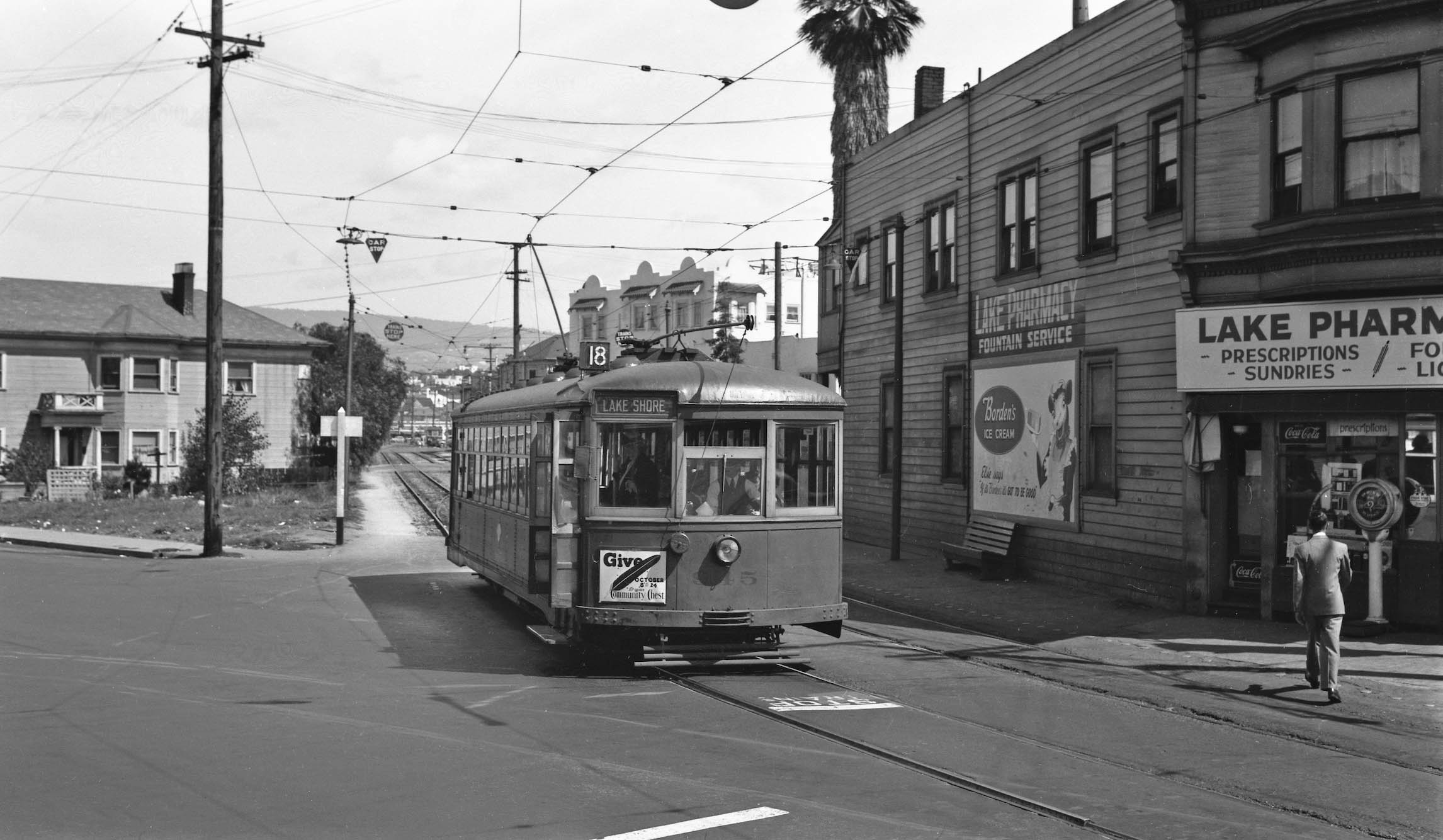
The tour begins at 1st Ave. with KS 945, Line 18 on Sept. 15, 1946. Line 18 used both this and the 3rd Ave. private right-of-ways to connect Park Blvd. and Lakeshore Ave. via Grand Ave. and Broadway. The street cars were replaced by buses on Mar. 28, 1948, ahead of the Nov. closing of the car house. Behind the car is a switch track and the grade crossing for E. 15th St. Any structures past the three-story apartment at no. 1444 1st. Ave Pl. seen behind the car have been replaced by the Lakeside Senior Apartments.
L335-70-Peter Kyhn Photo, Courtesy BAERA, Western Railway Museum Archives, 50612ks, (Image 16 of 36)
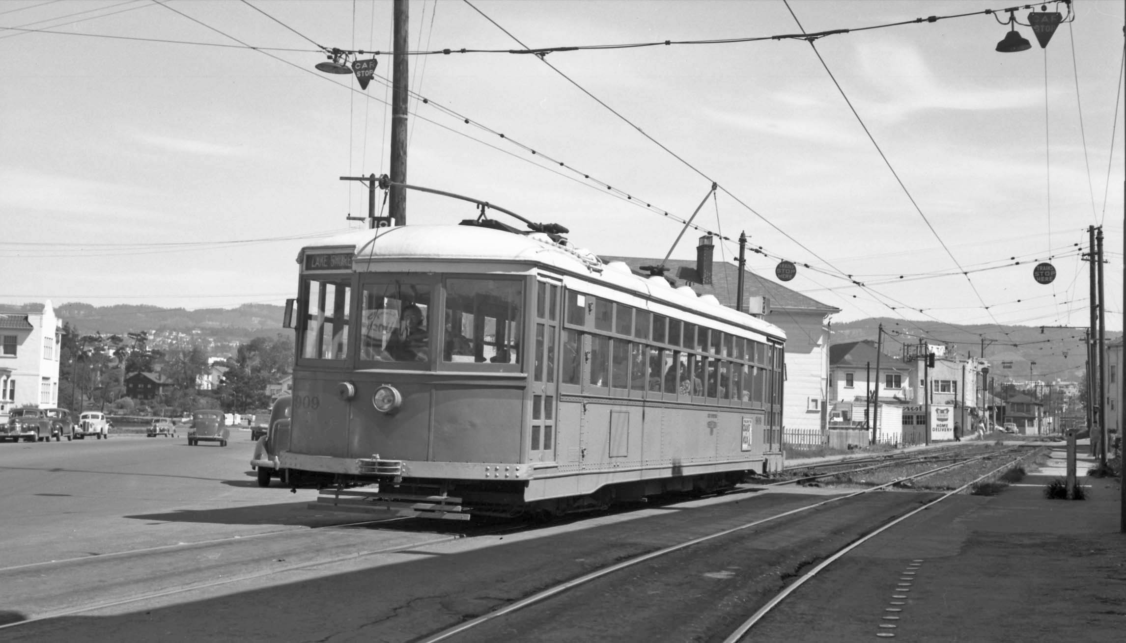
Relative to the previous image, KS 909, Line 18 at 1st Ave. and E. 14th St. on Feb. 16, 1948 shows no tree in front of no. 1450 1st Ave. Pl. Although mostly obscured by the streetcar, the house and the fence surrounding it have been remodeled. The one-story white structure to its right, and the two story house behind it that fronted on E. 16th St. persist in 2025, while the building with the Creamcrest sign and the apartment behind have been replaced by the Lakeside Senior Apartments. Refer to L335-60. The white apartment house on the north side of 1st Ave. on the left edge, no. 1501-1507, is still standing in 2025.
L335-75-Robert L. Stein Photo, Courtesy BAERA, Western Railway Museum Archives, 146108ks, (Image 17 of 36)
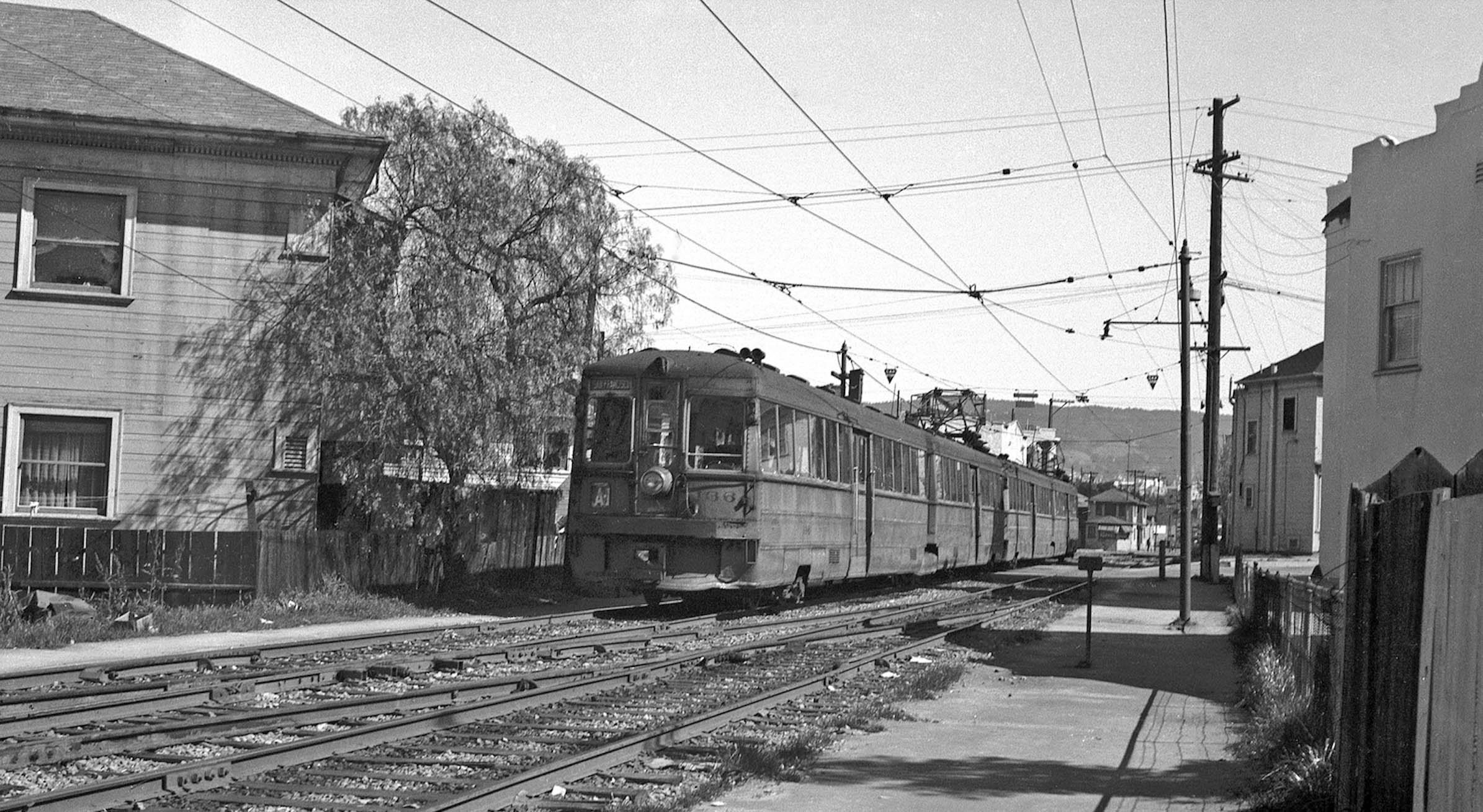
KS 136, interurban Line A-1 is seen on the private right-of-way between E. 14th and E. 15th Sts. heading to San Francisco in Mar. 1946. Relatives the previous image, the tree in front of no. 1450 1st Ave. is present, and the house and the fence surrounding it have not been remodeled. The house beside it, no. 1456 1st Ave., is smaller than the version since 1950. The A-1 line was created in 1941 to retain some original Line A service, while most A trains now used Interurban Electric Railway rails to Havenscourt. The A-1 was discontinued in 1946 according ito Harry Demoro’s “The Key Route, Part One”, Interurban Press, 1985.
L335-80-Ralph Demoro Photo, Courtesy John Harder, (Image 18 of 36)
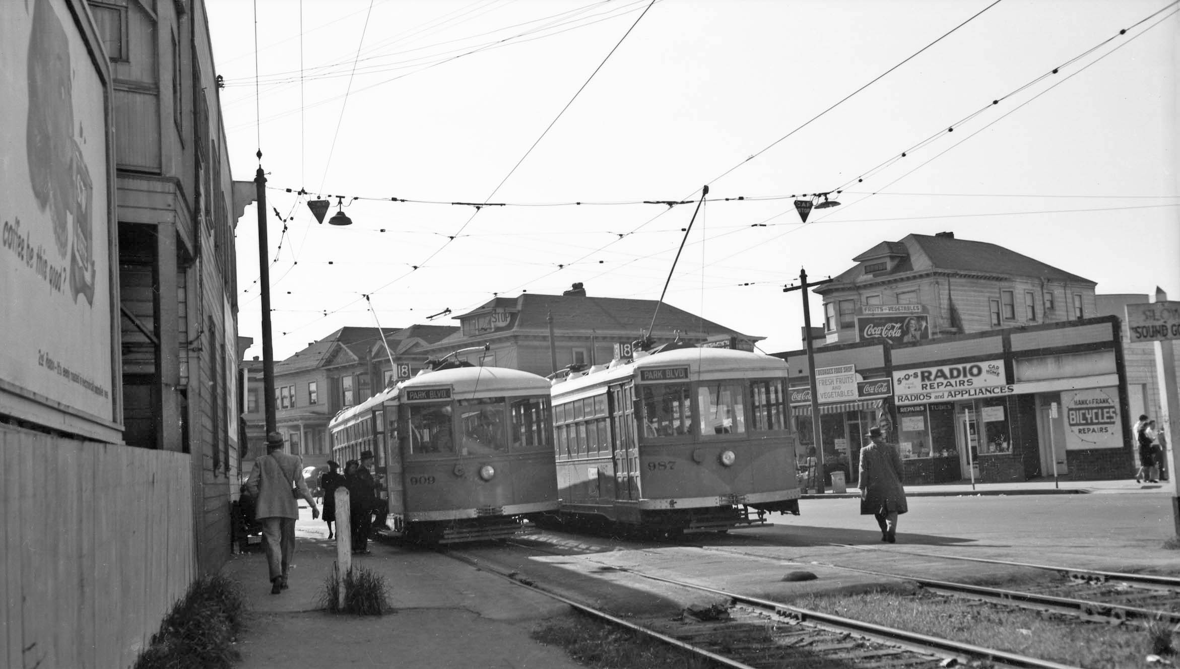
Now turning back to the southwest to 1st Ave. where KS 909 and KS 987, Line 18 meet on 1st Ave at E. 14th St., this southwest view from Oct. 1947. Note the storefronts along the west side of 1st Ave., including Hank and Frank Bicycle Repairs, still around in Lafayette celebrating 100 years in business in 2025.
L335-85-Courtesy BAERA, Western Railway Museum Archives, 178373ks, (Image 19 of 36)
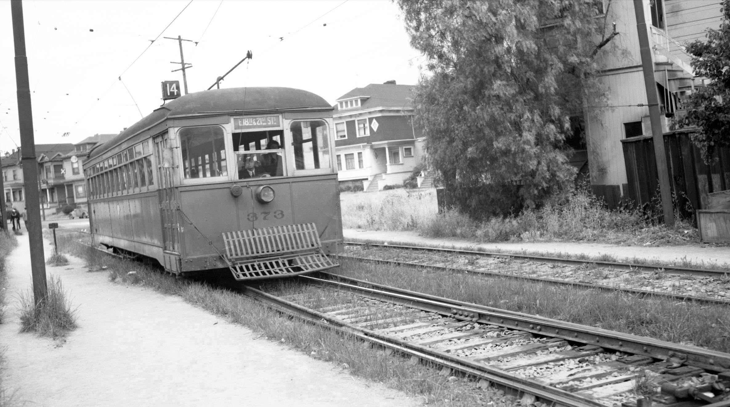
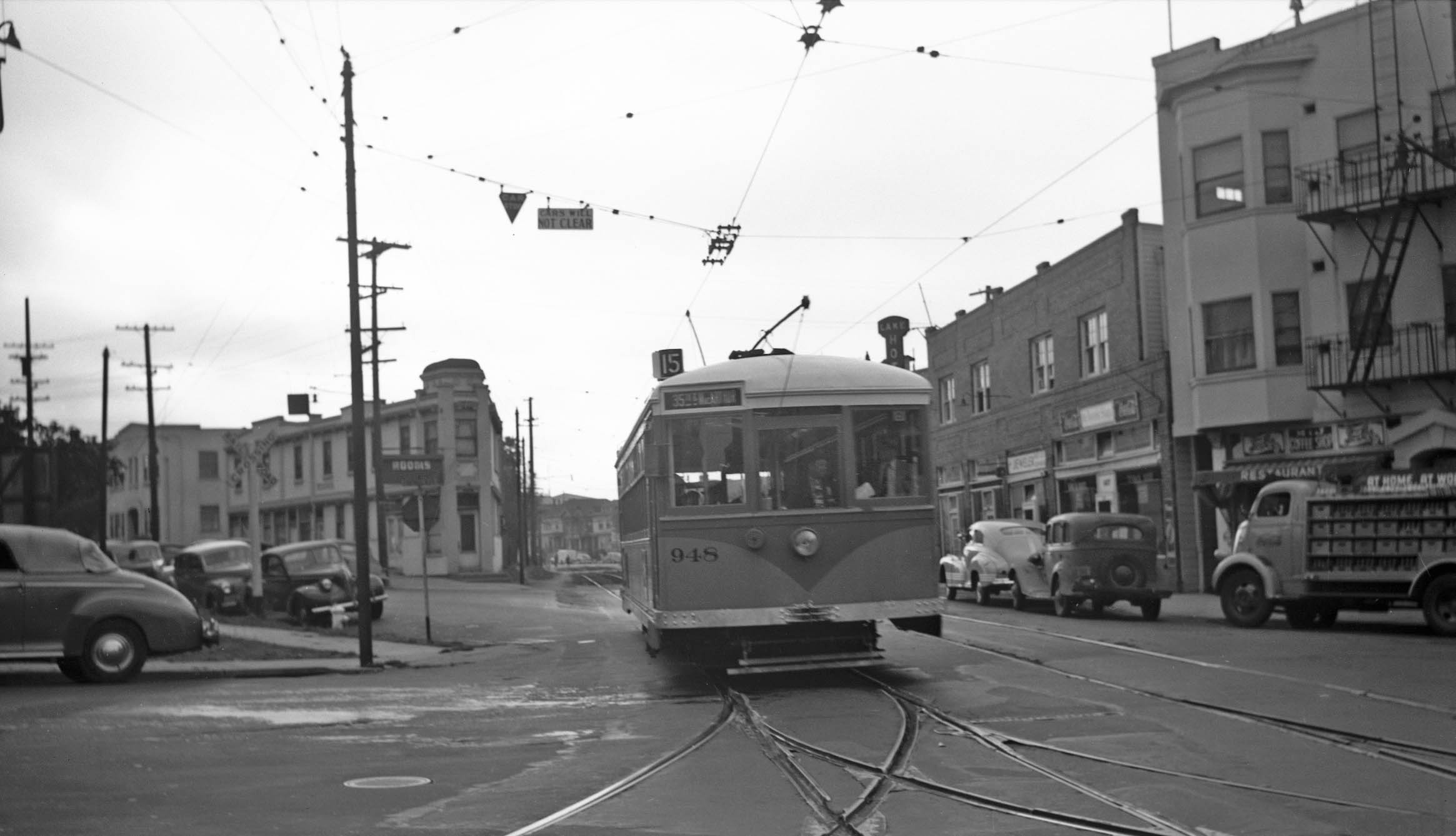
This southwest view of KS 373 with fender, Line 14 is eastbound from the stop at 1st Ave at E. 14th. The house seen to its right on 1st Ave. is no. 1441, still present in 2025, but all the houses to its left are gone. The tree in front of no. 1450 1st Ave. Pl. is present, so the date is 1946 or earlier. Line 14 experienced many route changes, but went from the Southern Pacific’s 16th St. station to Fruitvale Ave. and E. 27th St., the stop at the station cutback to 13th St. and Jefferson St. in 1943. In addition to this right-of-way, it used the short one to E. 18th St. As with Line 18, it was abandoned on Mar. 28, 1948.
L335-90-Gordon Zahorik Collection, Courtesy BAERA, Western Railway Museum Archives, 131127ks, (Image 20 of 36)
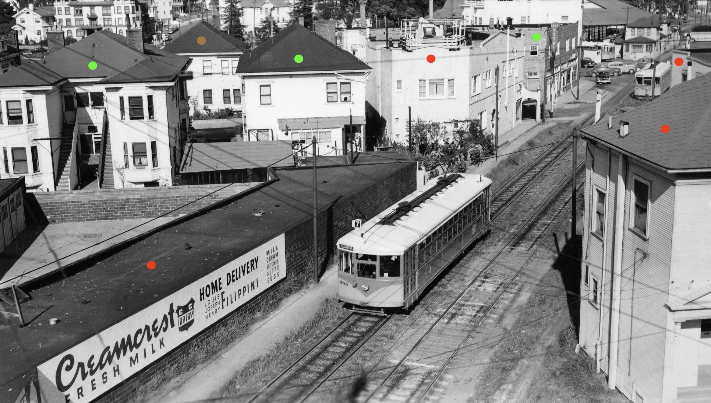
Bill Billings panoramic northeast view was taken from the roof of no. 1444 1st Ave. Pl. ca. 1948 with KS 988, Line 7. Everything with a green dot survives into 2025, everything with a red dot was on land used for Lakeside Senior Apartments, and the structure with a brown dot no longer exists on E. 16th St. unrelated to the apartments. A reference to Creamcrest Dairy, click here, notes it was in the East Bay between 1935-1963, but it omits the building here that fronted at no. 1508 1st Ave. This was not part of the Line 7 route, so this car was heading out to its mainline or this was part of an excursion or training session.
L335-95-William S. Billings Photo, Courtesy BAERA, Western Railway Museum Archives, 225193ks copy, (Image 21 of 36)
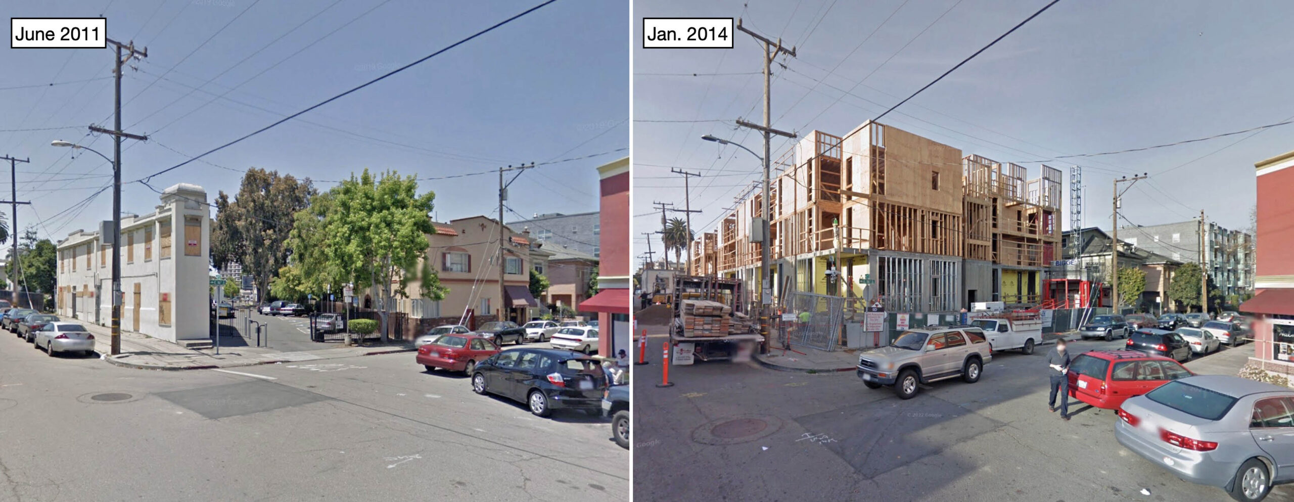
A southwest view from E. 16th St. archived on Google Maps shows that the right-of-way toward E. 15th St. was a parking lot in 2011, left. Based on historic aerials.com, the large lot was created sometime between 1968 and 1980 when the structures on the northwest corner of E. 15th St. and 2nd Ave. were cleared creating more space beyond the rail path. The image from 2014 on the right is consistent with what was shown from the other direction in L335-65.
L335-100-Courtesy Google Maps, (Image 22 of 36)
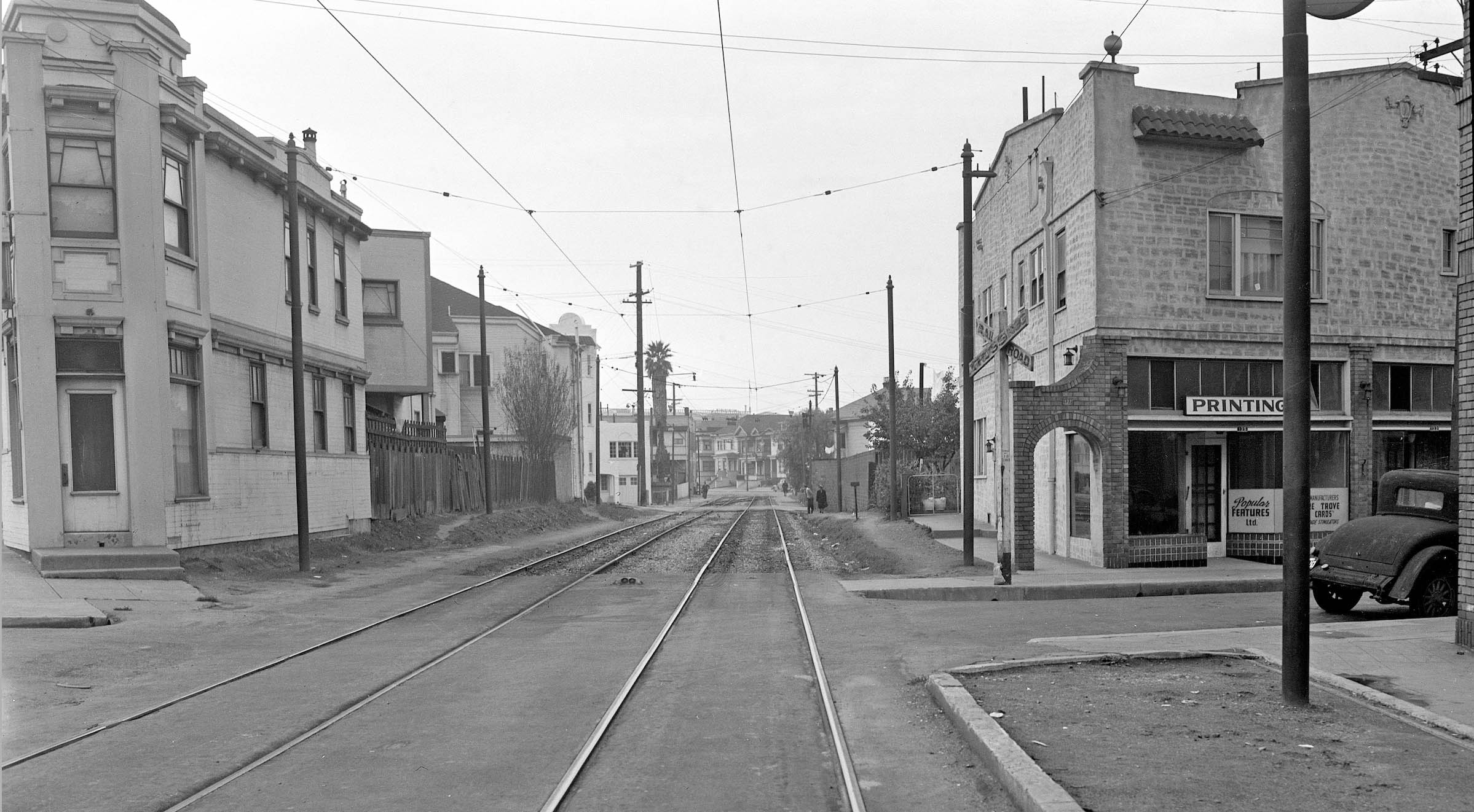
A southwest, undated view displays all the structures along the private right-of-way between E. 15th and E. 16th Sts. All of these structures were razed at some point prior to 2011 to make room for the senior apartments. The outward appearance of commercial space on the house on the right appears more than what was there in 2011 in the previous comparison. What little can be seen of the license plate on the car on the right edge suggests the date is 1935.
L335-105-Key System Photo, Courtesy John Harder, (Image 23 of 36)
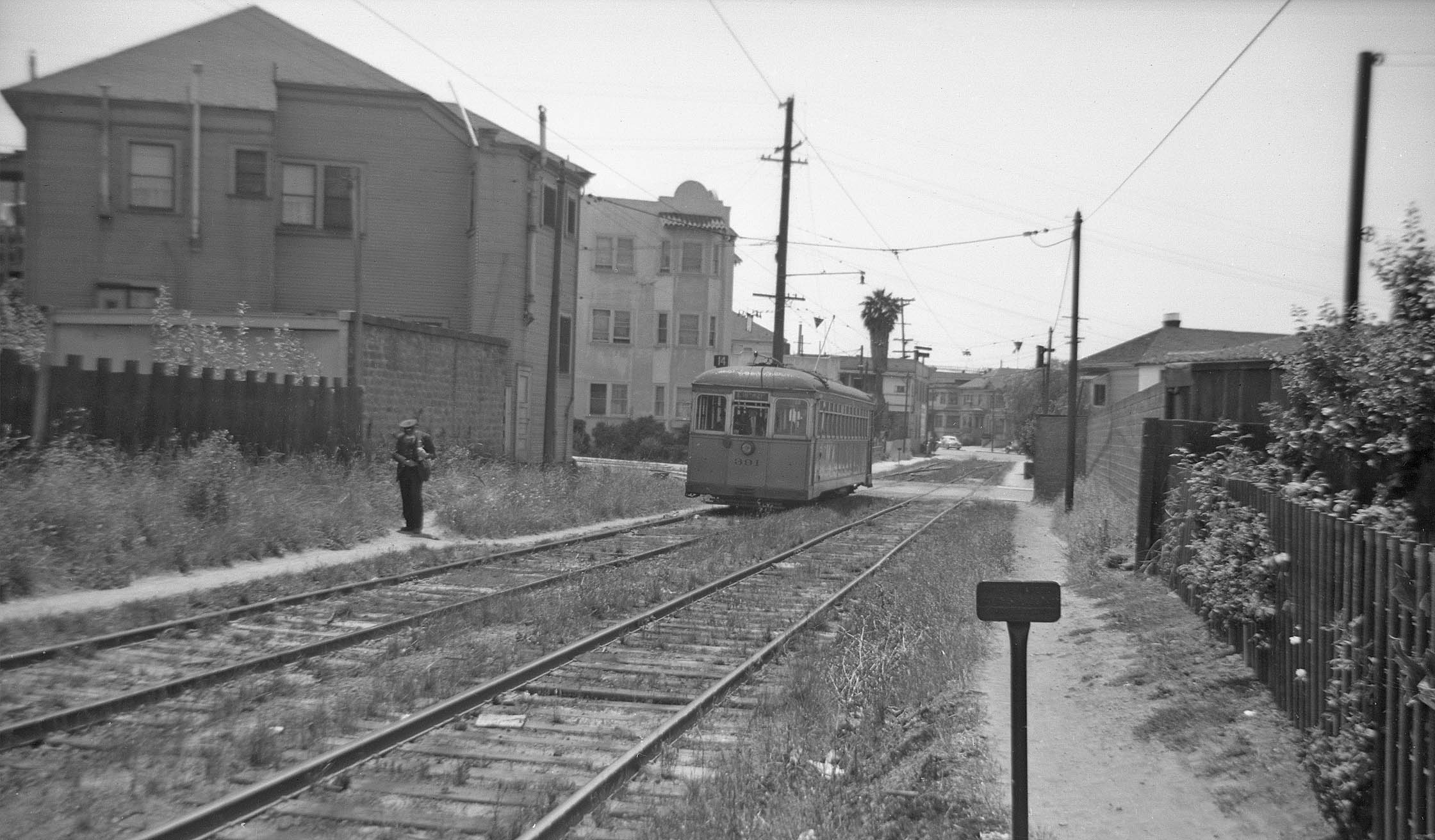
KS 391, Line 14 sits just past the E. 15th grade crossing in this southwest view form July 3, 1942.
L335-110-Peter Kyhn Photo, Courtesy BAERA, Western Railway Museum Archives, 134035ks, (Image 24 of 36)
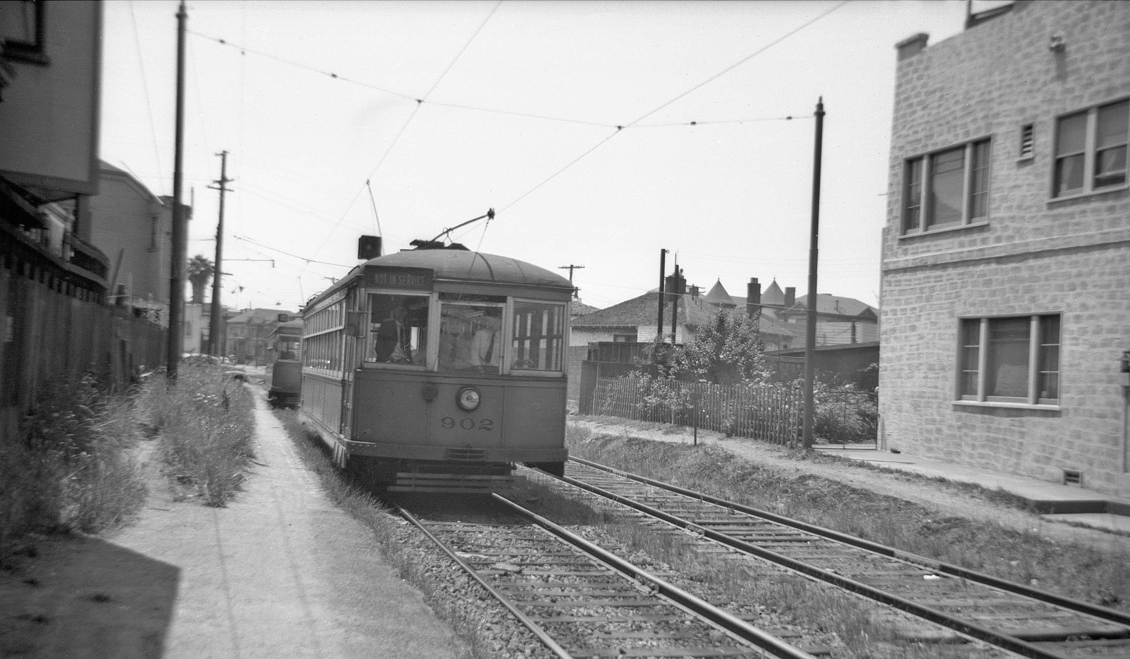
KS 902, out of service, and a Line 10 car sit between E. 15th St. and E. 16th St. in this southwest view, July 5, 1942. KS 902 was used to take a student motorman over all lines. Line 10 ran from Piedmont to Hopkins St. and 35th Ave. Like Line 14, In addition to this right-of-way, Line 10 used the short one to E. 18th St. It was abandoned on June 1, 1948.
L335-115-Peter Kyhn Photo, Courtesy BAERA, Western Railway Museum Archives, 134308ks, (Image 25 of 36)
Sitting just southwest of the 16th St. grade crossing, KS 909, Line 2 must also be coming from the car house or is part of an excursion as it did not come to this area of Oakland. The building behind the streetcar has been featured in several previous images, broken into three addresses originally at nos. 131, 133, and 135-37 E. 16th St. As shown in L335-100, it survived until the Lakeside Senior Apartments were built, its exterior having been painted a reddish-tan color to hide the stone pattern seen in this image.
L335-120-Arthur Lloyd Photo, Courtesy BAERA, Western Railway Museum Archives, 110907ks, (Image 26 of 36)
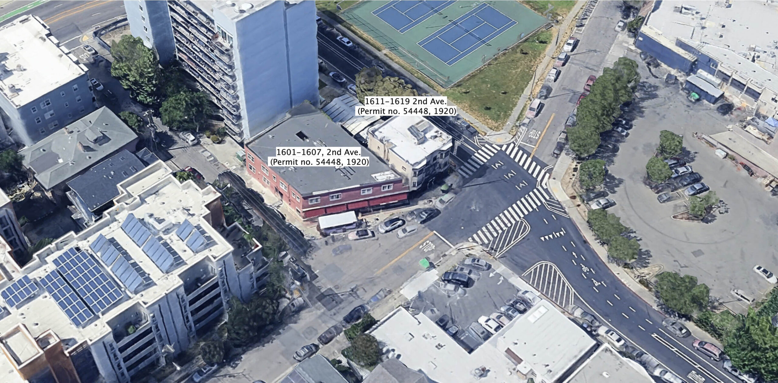
Northeast of E. 16th St., these structures from 1920 line the northwest side of the private right-of-way as it crossed 2nd Ave. in 2025. The parking lot and building across on the southeast side of 2nd Ave. were completed sometime between 1952 and 1958 based on the 1952 Sanborn and a 1958 aerial, respectively, and the space had been almost entirely empty before that. Refer to the Sanborn maps in L335-37.
L335-125-Courtesy Google Maps, (Image 27 of 36)
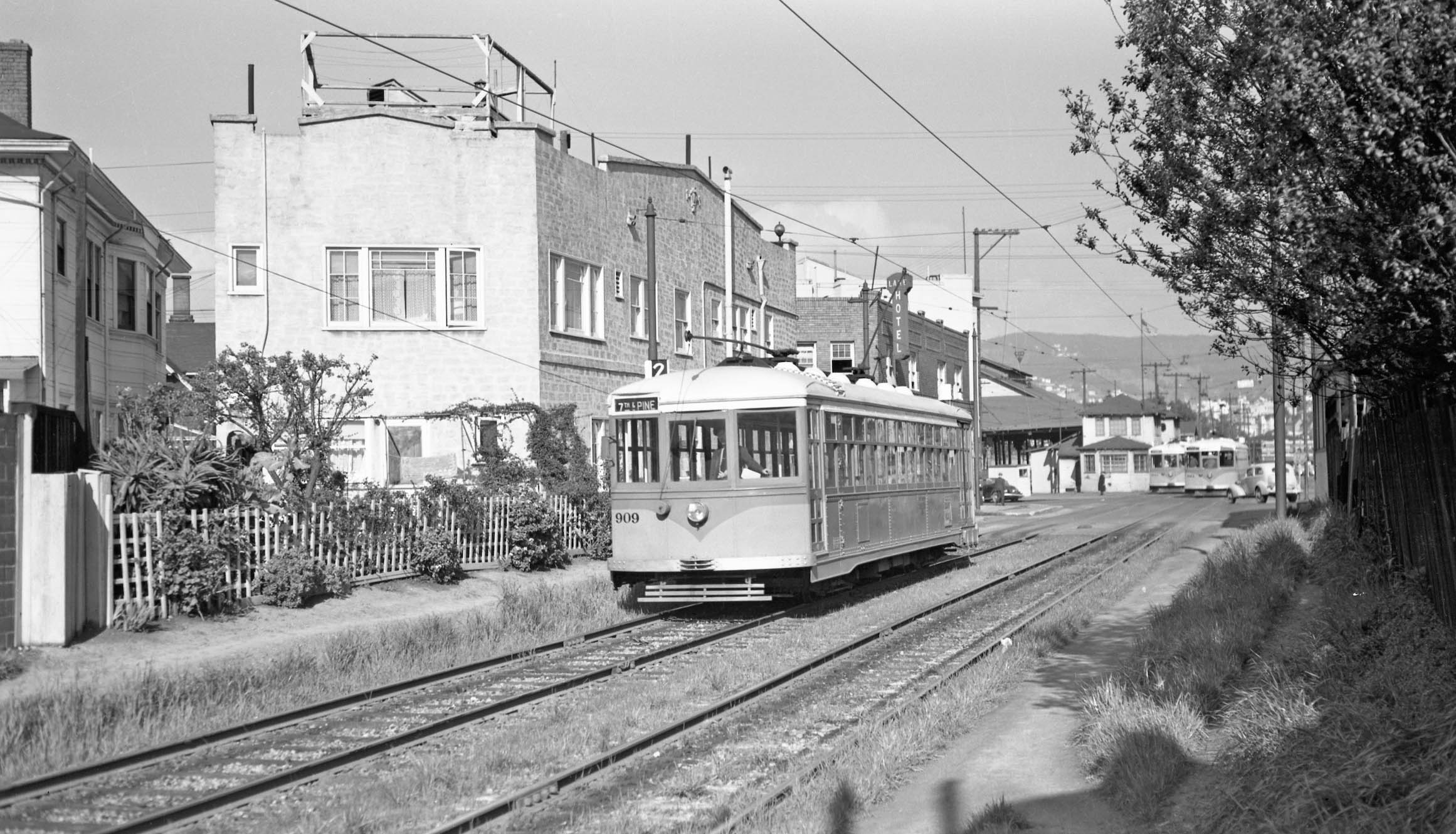
KS 976, line 15 is inbound at 2nd Ave. and Foothill Blvd., across From the Central Car House, southwest view on Nov. 23, 1947. The private right-of-way is in the background. The buildings to the right survive in 2025, the ones to the left were razed in 2011. Compare to L335-100. This was the second iteration of Line 15, this portion had been part of Line 10 that was divided up by order of the Office of Defense Transportation on Sept. 26, 1943 according to Sappers.
L335-130- Roy Covert Photo, Courtesy BAERA, Western Railway Museum Archives, 54088ks, (Image 28 of 36)
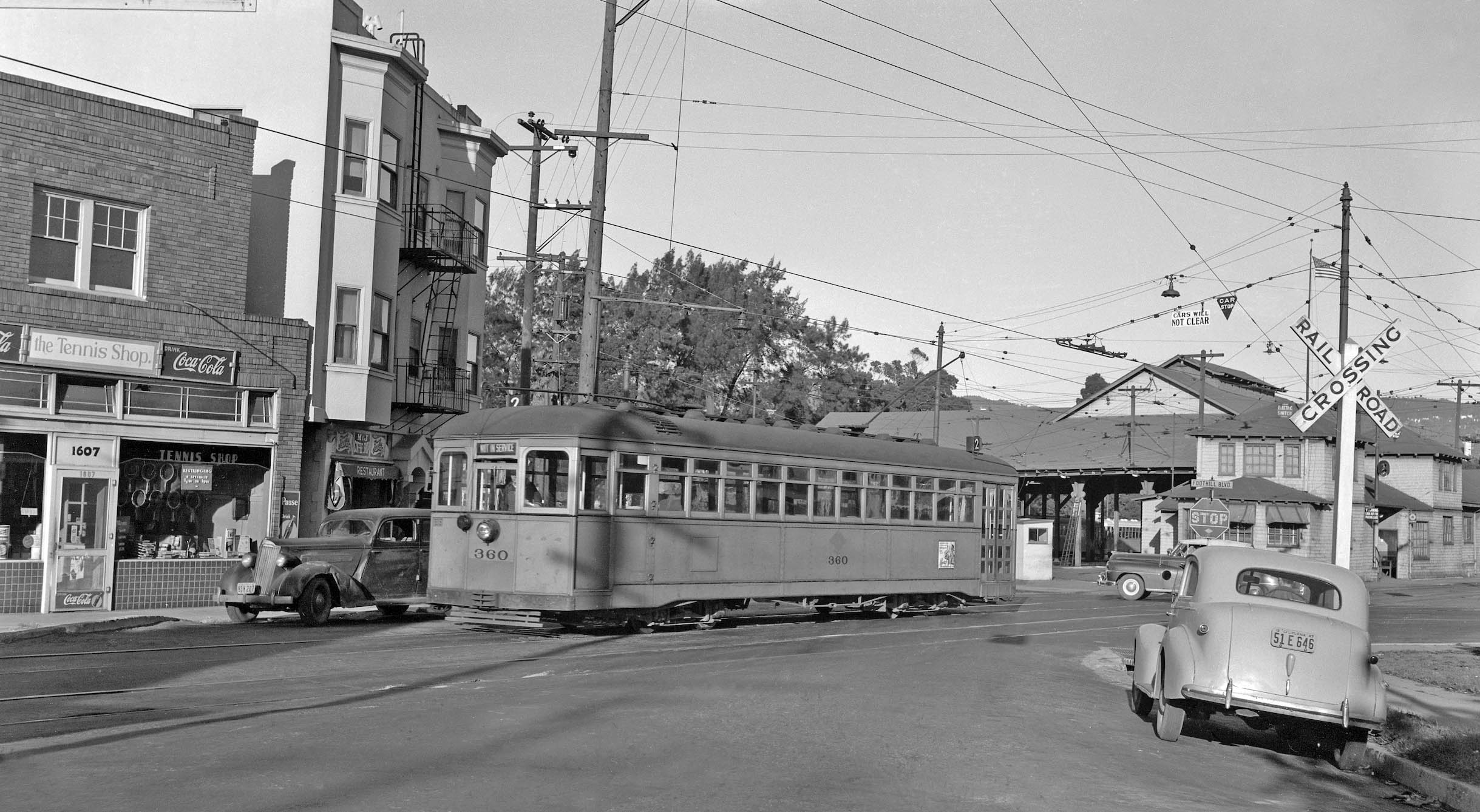
Out of service KS 360, Line 2 crosses Foothill Blvd, after leaving Central Car House on Nov. 16, 1947, north view. Note no. 1607 2nd Ave. as The Tennis Shop, and to its right, M&J Coffee Shop Restaurant at no. 1611.
L335-135-Waldemar Sievers Photo, Courtesy John Harder, (Image 29 of 36)
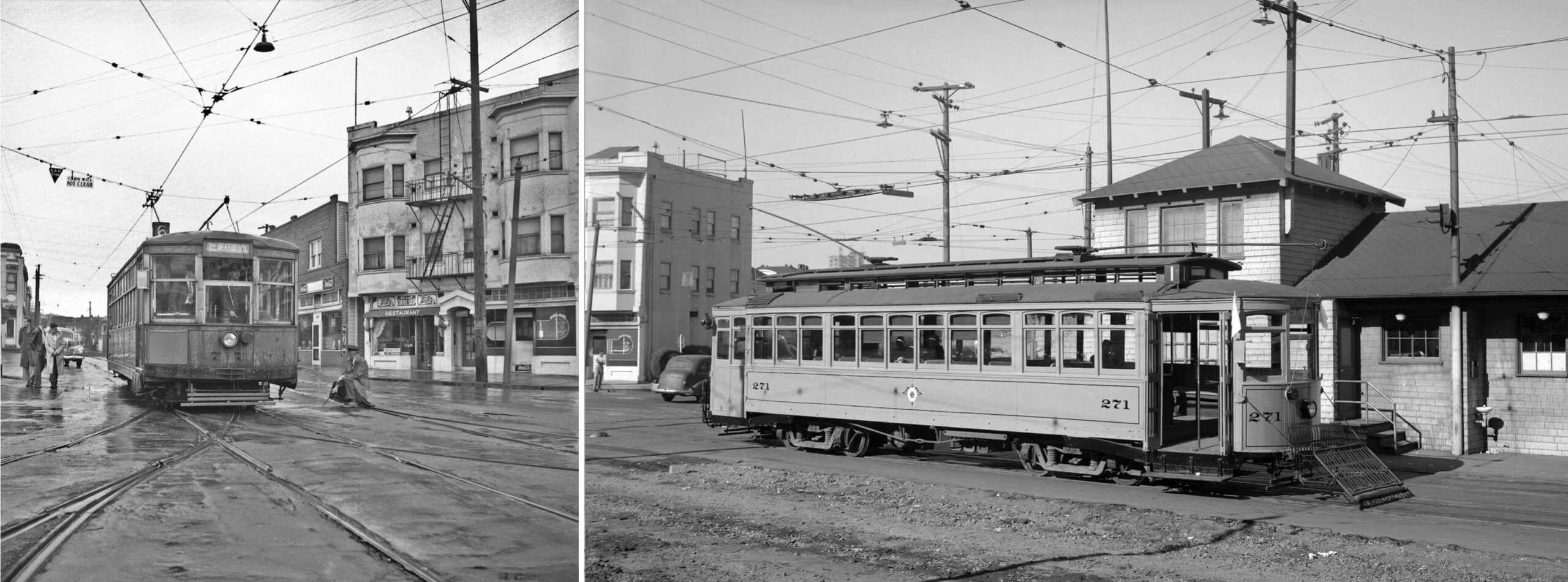
Two more south views of the building at the corner of 2nd Ave. and Foothill Blvd. are shown here. The image of KS 717, Line 6 on the left shows an employee setting the switch to a streetcar line that did not use this car house. On the right, KS 271 is on excursion during the final days of Nov. 1948 signaling the closure of the car house and abandonment of the whole streetcar system.
L335-140-Ralph Demoro Photo, l, Unidentified, r, Courtesy John Harder, (Image 30 of 36)
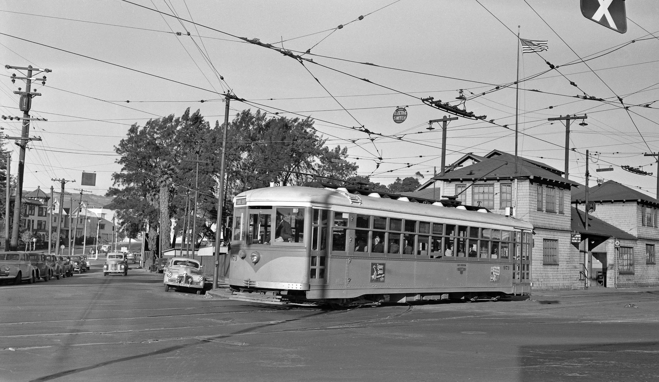
A rare new north down 2nd Ave. as KS 973, Line 18 departs the Central Car House in 1948.
L335-145-John Harder Collection, Courtesy John Harder, (Image 31 of 36)
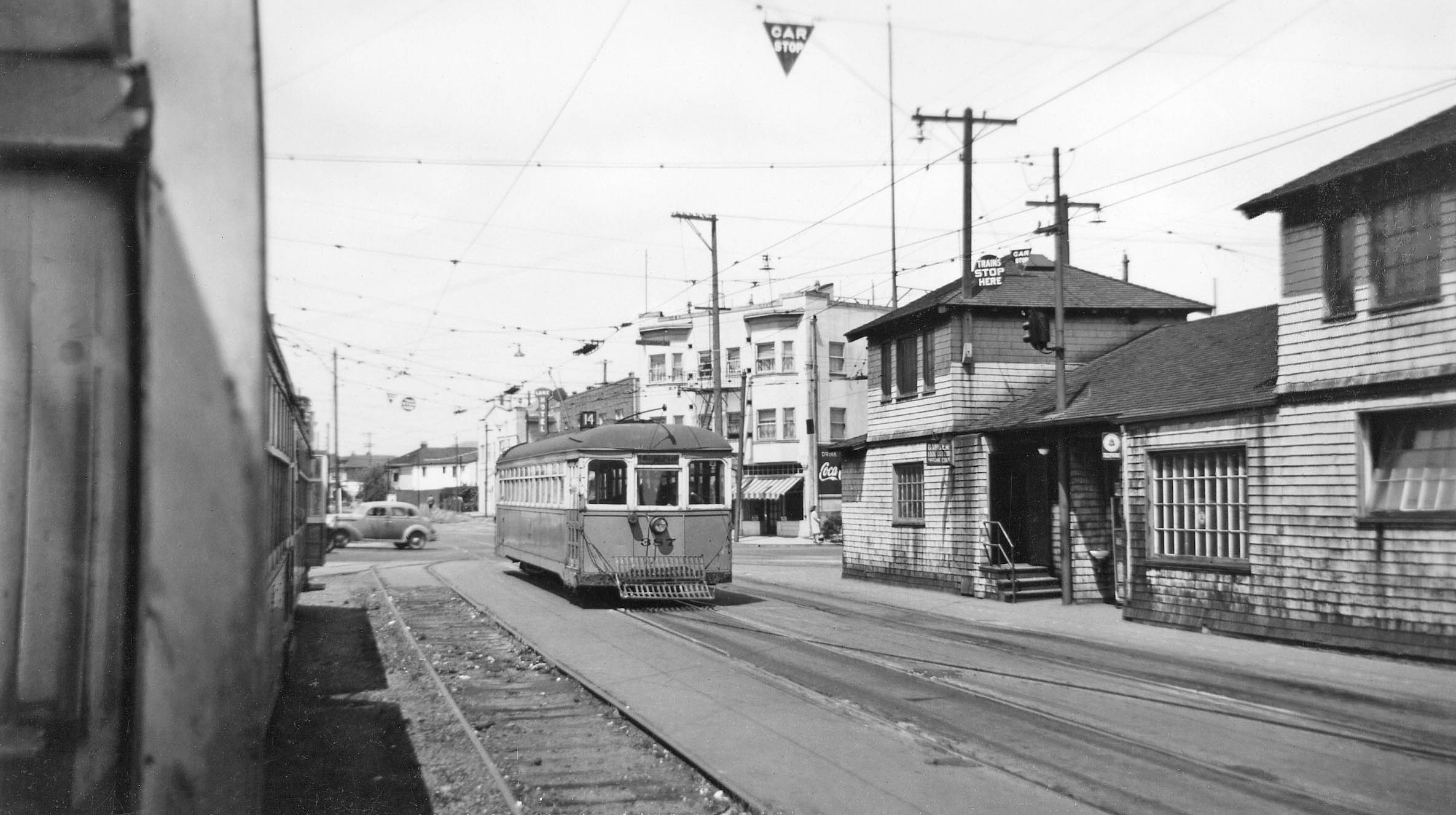
Once past Foothill Blvd., KS 387, Line 14 glides past the Central Car House office and a row of streetcars on May 31, 1942, southwest view.
L335-150-Peter Kyhn Photo, Courtesy BAERA, Western Railway Museum Archives, 134028ks, (Image 32 of 36)
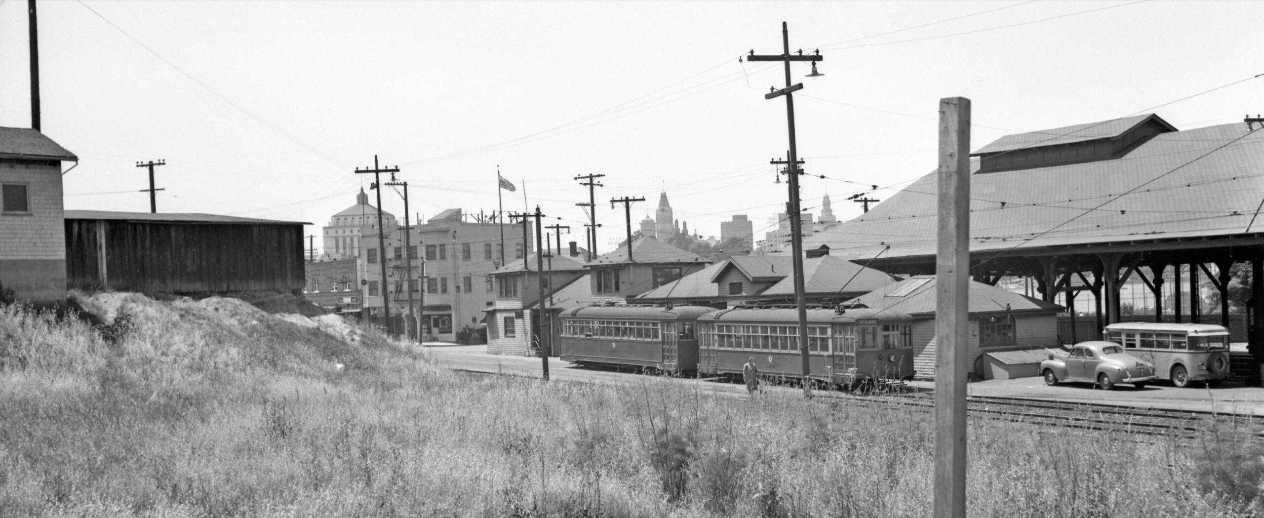
Key System employee Peter Kyhn got most of the Oakland skyline including the courthouse, Tribune Tower and City Hall in this west view where Line 14 and Line 15 streetcars are lined up to head west, on May 15, 1946.
L335-155- Peter Kyhn Photo, Courtesy BAERA, Western Railway Museum Archives, 134060ks, (Image 33 of 36)
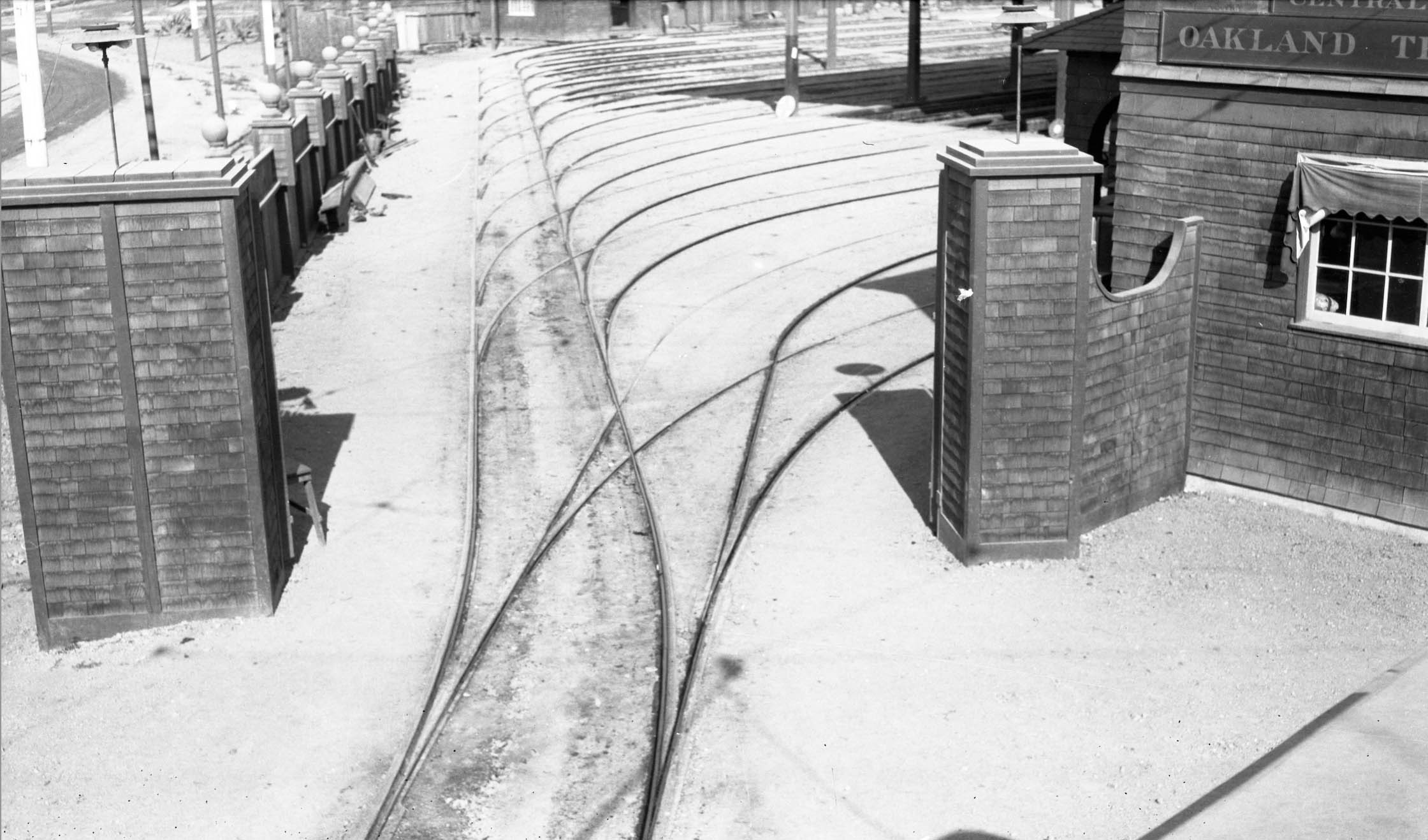
Finally, a few additional interesting or historically relevant images from the Central Car House. First, a north view from the recently completed Central Car House ca. 1906 viewed from a streetcar at 2nd Ave. and Foothill Blvd. showing the ladder track along the 2nd Ave. side of the facility.
L335-160-Key Official Photo, Robert L. Stein Collection, Courtesy BAERA, Western Railway Museum Archives, 156660ks, (Image 34 of 36)
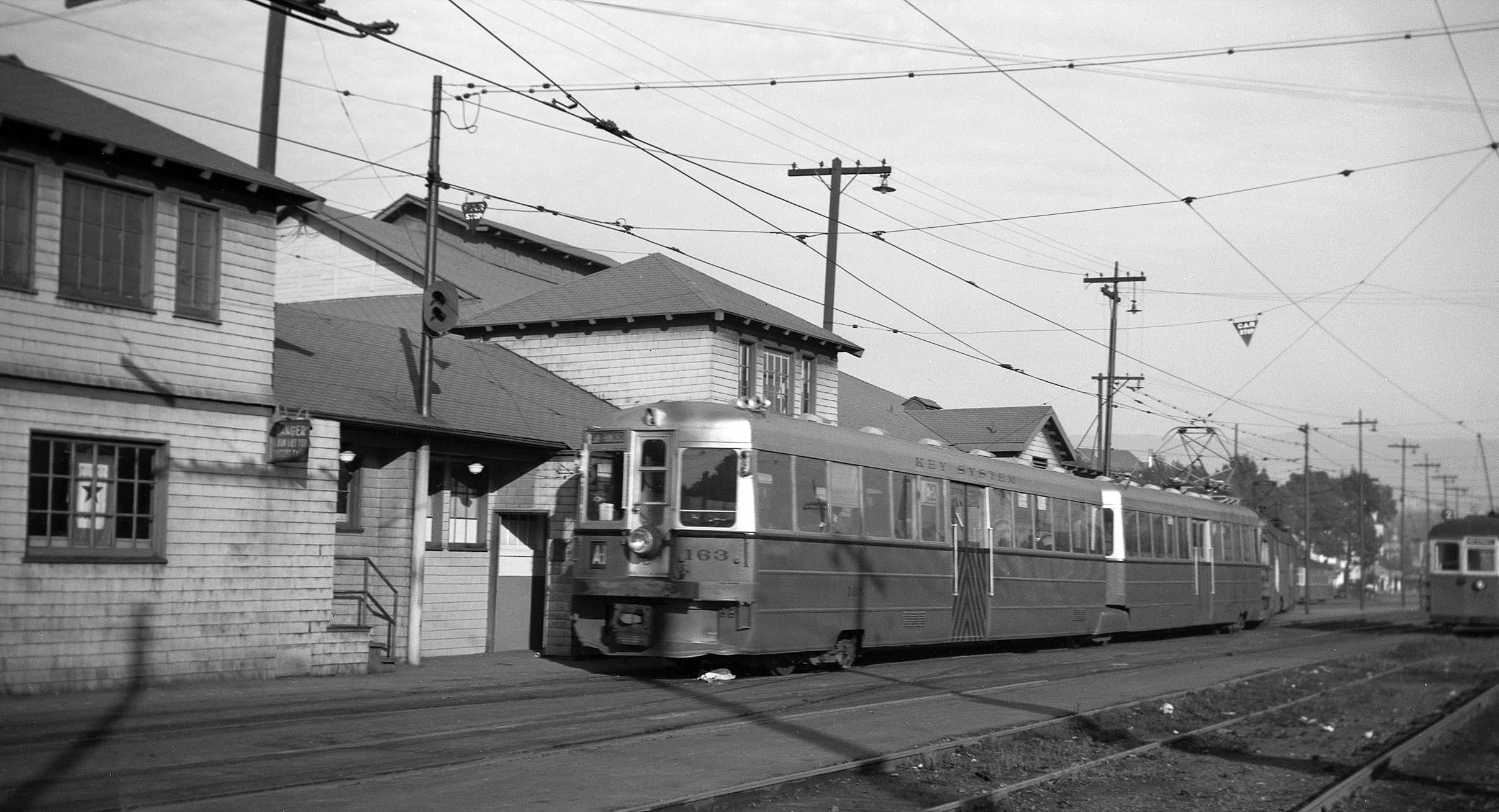
A rare image of an interurban Line A-1 alongside the station in 1943, north view.
L335-165-John Harder Collection, Courtesy John Harder, (Image 35 of 36)
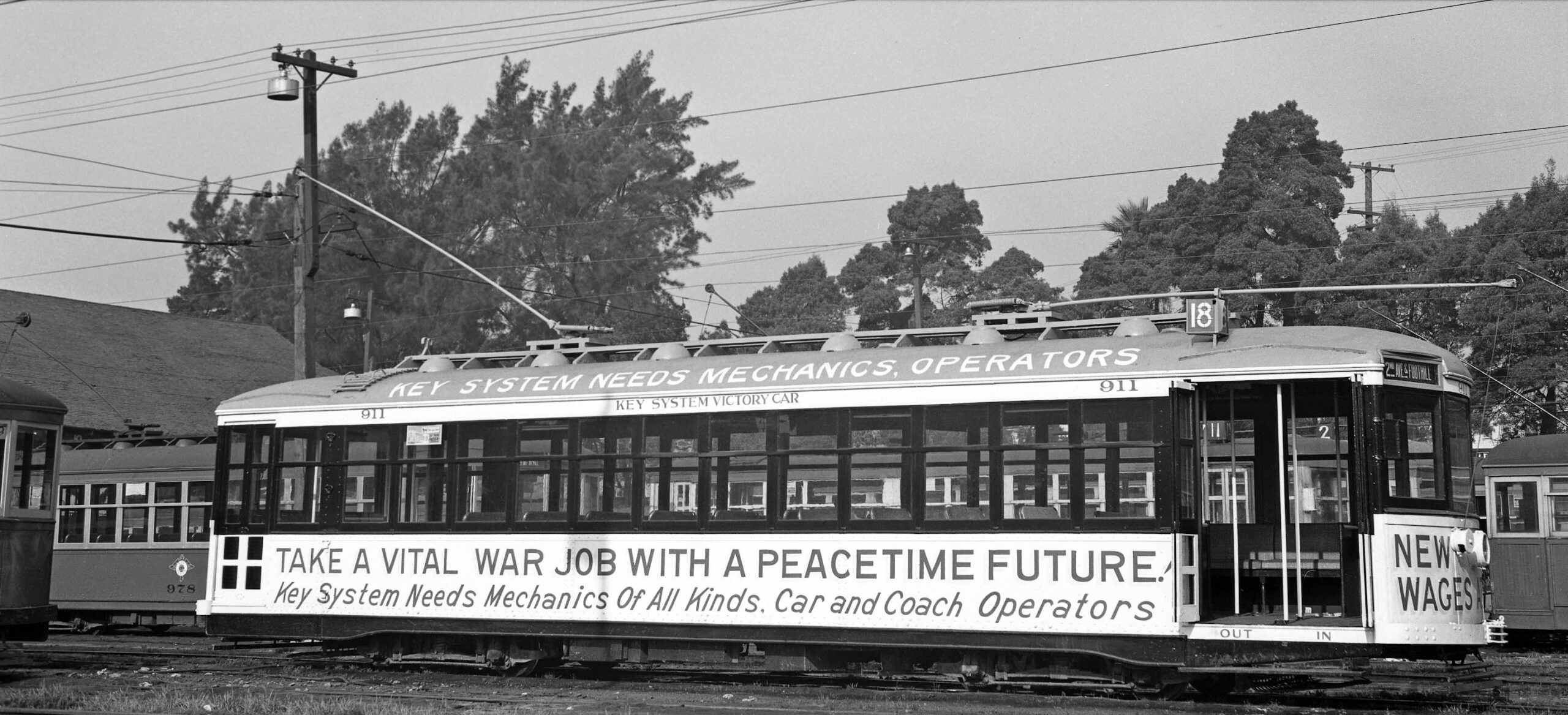
The war effort had an impact on the Key System operation in general as exhibited on KS No. 911 at the Central Car House in 1945. Appreciation to John Harder for the many images provided from his collection. Next time, the private right-of-ways north of the Central Car House.
L335-170-Leon L. Bonney Photo, Courtesy John Harder, (Image 36 of 36)