1912-1920 – The Road to Northbrae
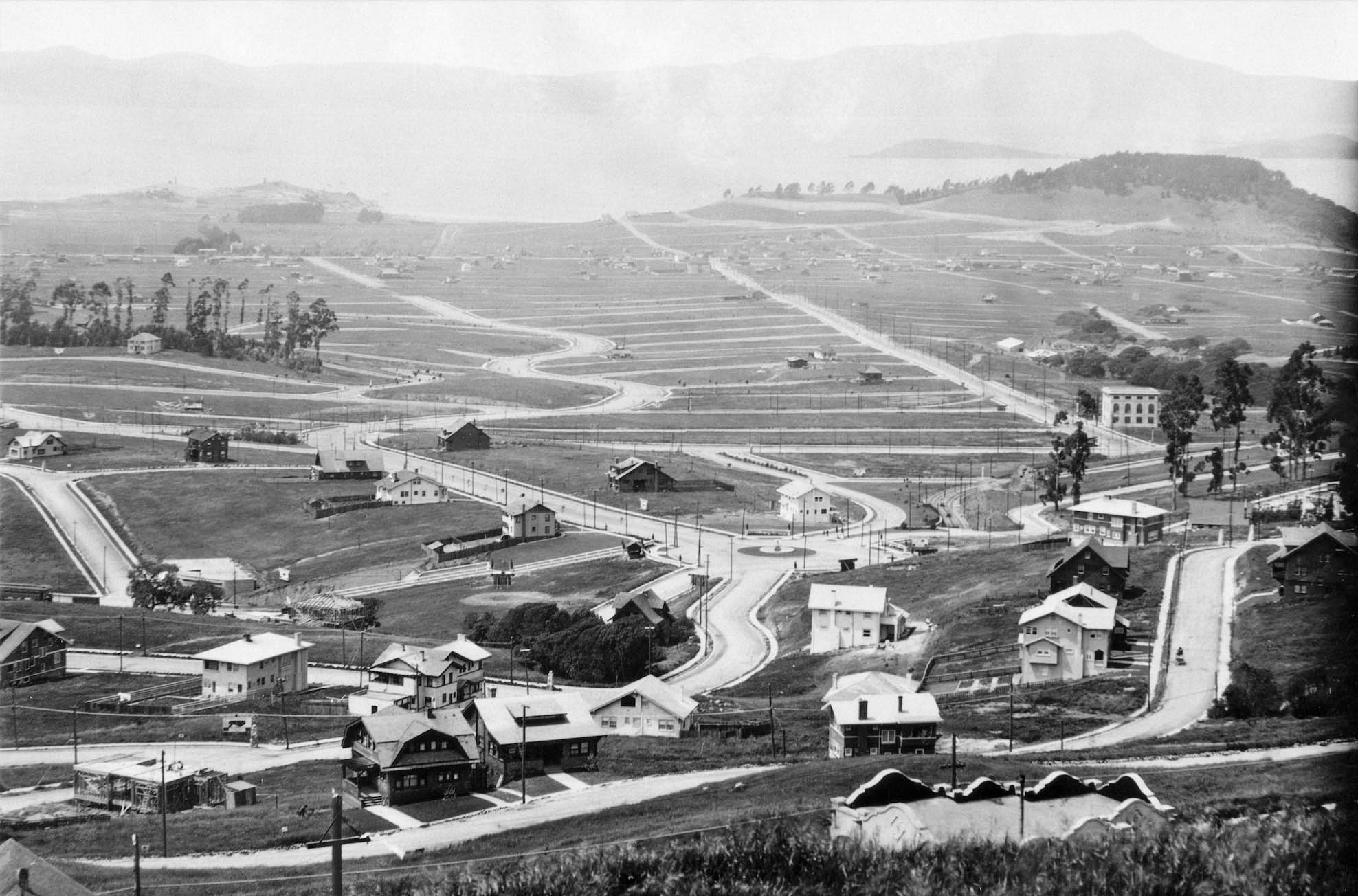
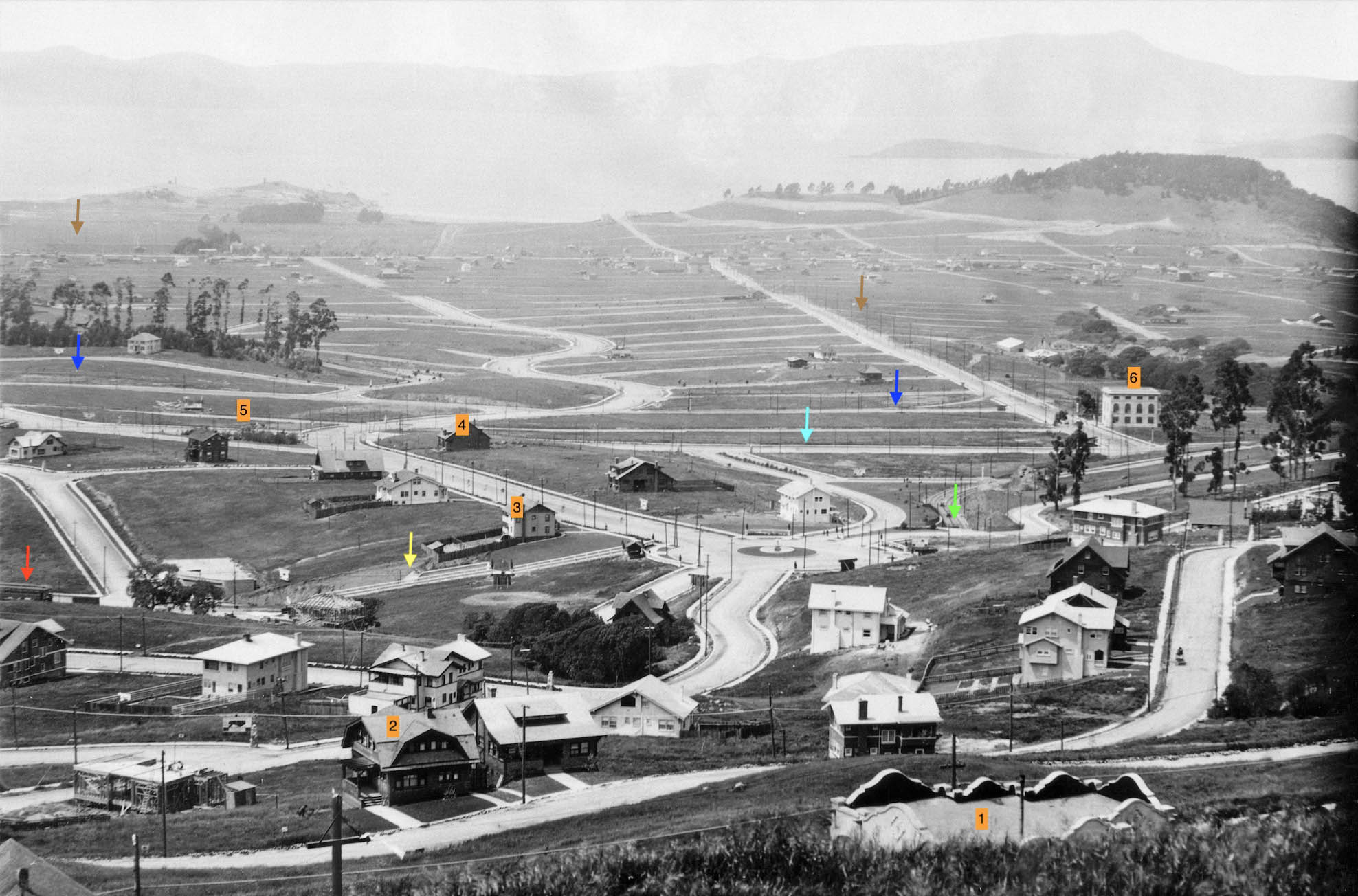
This west view above Northbrae taken from above Spruce St. on Apr. 27, 1912 shows off the north end of the Southern Pacific, SP, Oakland, Alameda and Berkeley, OA&B, suburban railway designed and built between 1905-1912 for $10.6M according to Robert Ford in his book. “Red Trains in the East Bay”, Interurbans, 1977. This update will include some images of early Northbrae, and focus mainly on the paths taken by the SP and the Key System, Key, on their Shattuck Ave. lines between 1912-1920. An annotated version of this image follows.
L346-05-Southern Pacific Photo, Courtesy BAERA, Western Railway Museum Archives, 55597oa&b, (Image 1 of 33)

side from structures marked 1 and 2, the other items have already been identified in the previous updates in this series, and 1-4 remain in 2026. 1, no. 1035 Spruce St.; 2, no. 1024 Oxford St.; 3, no. 1994 Marin Ave.; 4, no. 1919 Marin Ave.; 5, Mason-McDuffie Sales Office; 6, SP Substation; red arrow, SP Shattuck Train at Northbrae stop; yellow arrow, Sutter St.-side portal of Northbrae Tunnel; green arrow, Solano Ave.-side portal of Northbrae Tunnel; turquoise arrow, The Alameda streetcar line to Solano Ave; blue arrow, SP California St. line, the line splits to form the Colusa Ave. “wye”; brown arrows, SP Ninth St. line.
L346-06-Southern Pacific Photo, Courtesy BAERA, Western Railway Museum Archives, 55597oa&b copy, (Image 2 of 33)
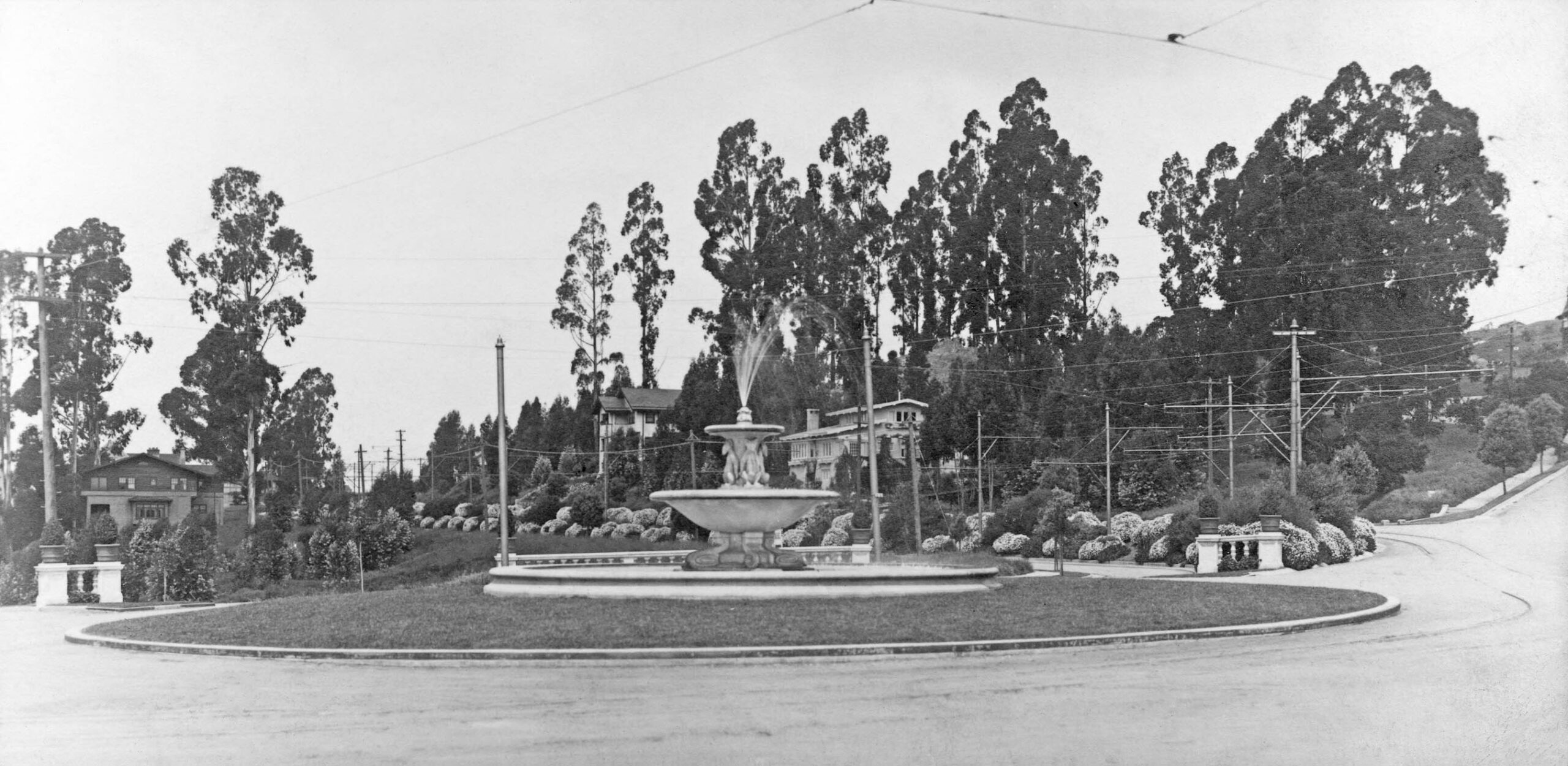
Designed by architect John Galen Howard, the fountain and balustrade at the Circle were completed in 1911 after the Northbrae Tunnel project was completed. North view, ca. 1912.
L346-10-Vernon Sappers Collection, Courtesy BAERA, Western Railway Museum Archives, 252321bv, (Image 3 of 33)
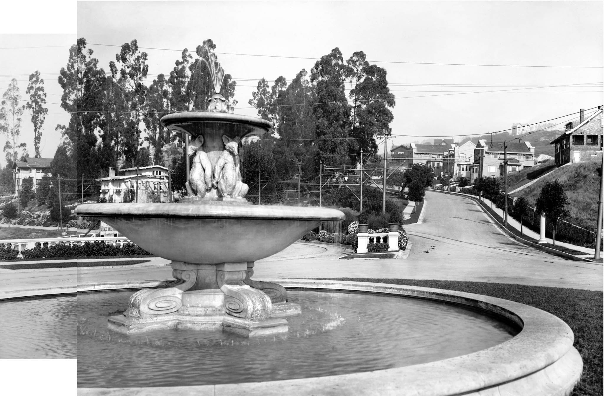
This composite image ca. 1912 shows details for the fountain and the streetcar tracks up Arlington Ave. According to Vernon Sappers’ “Key System Street Cars” Signature Press, 2007, the Key interurban and streetcar systems were merged in March 1912 as the S.F.-Oakland Terminal Railways, and the “Key Route” became the “Key System.” More about this subject in the next update.
L346-15-Sappers Collection, Courtesy BAERA, Western Railway Museum Archives, 252322bv, (Image 4 of 33)
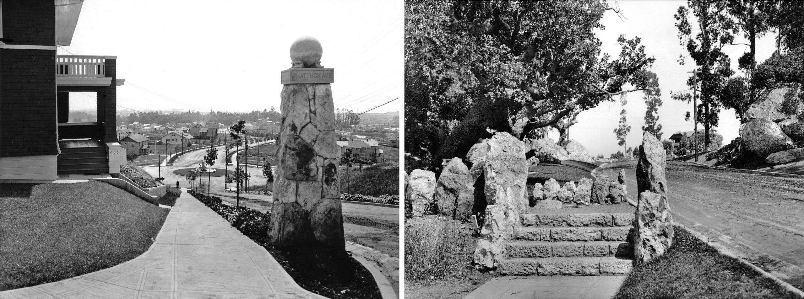
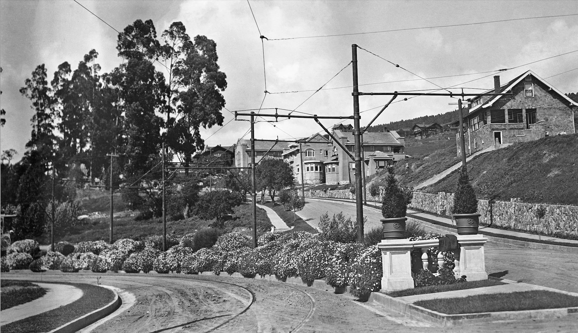
These two images ca. 1912 reveal that Northbrae was a well-planned subdivision, such that much of the landscaping was created before lots were sold. On the left, a southwest view down Marin Ave. at Shattuck Ave. The stone corner pillar seen here was designed by John Galen Howard. Many were created and still exist in the neighborhood in 2026, but not this one. The image on the right indicates that many of the fine stone-based structures were set against natural borders such as Indian Rock Park and were created before roads were paved.
L346-20-Sappers Collection, Courtesy BAERA, Western Railway Museum Archives, 252322bv, (Image 5 of 33)
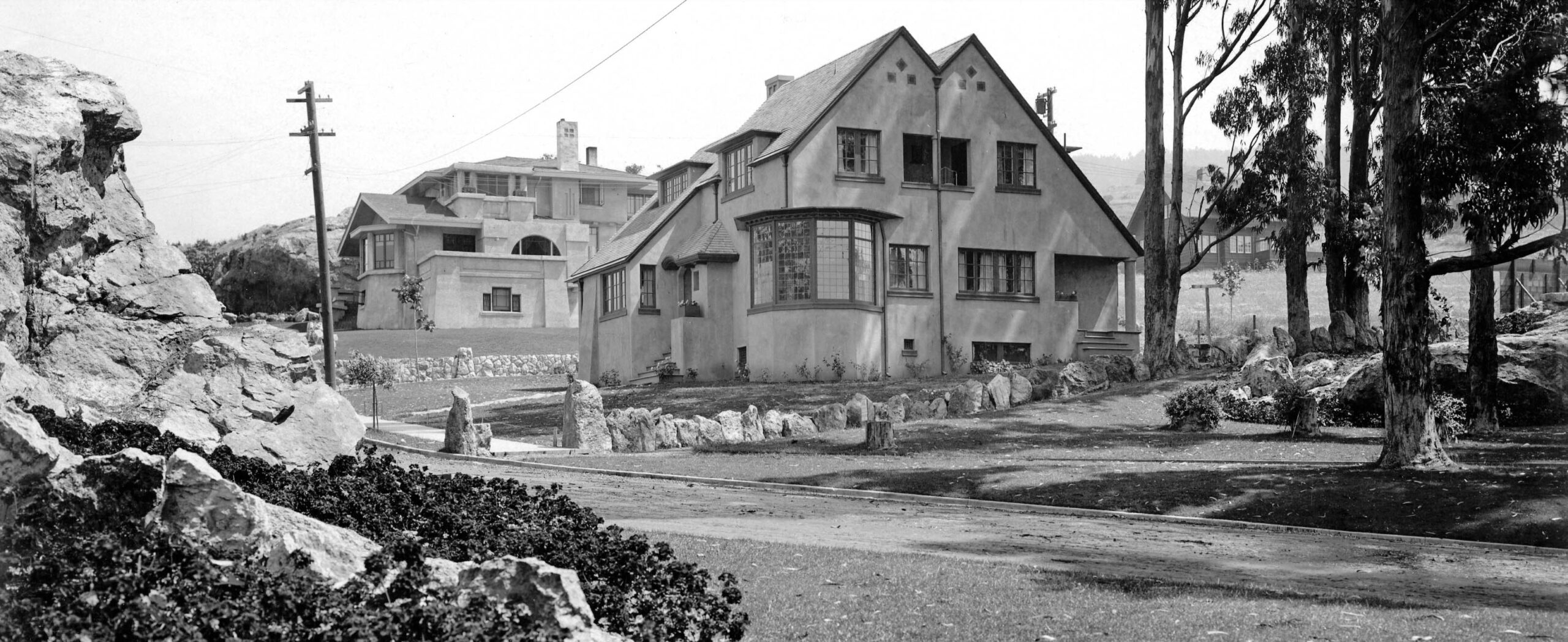
The area attracted many top-name local architects, here a north view of two houses designed by John Hudson Thomas in 1910 at Indian Rock Ave. and Oxford St.; no. 915 Indian Rock Ave., left, no. 927 Indian Rock Ave., center, as well as a house not designed by Thomas on the right at no. 875 Indian Rock Ave. The two houses by Howard still exist, but have been modified.
L346-25-Sappers Collection, Courtesy BAERA, Western Railway Museum Archives,252327bv, (Image 6 of 33)
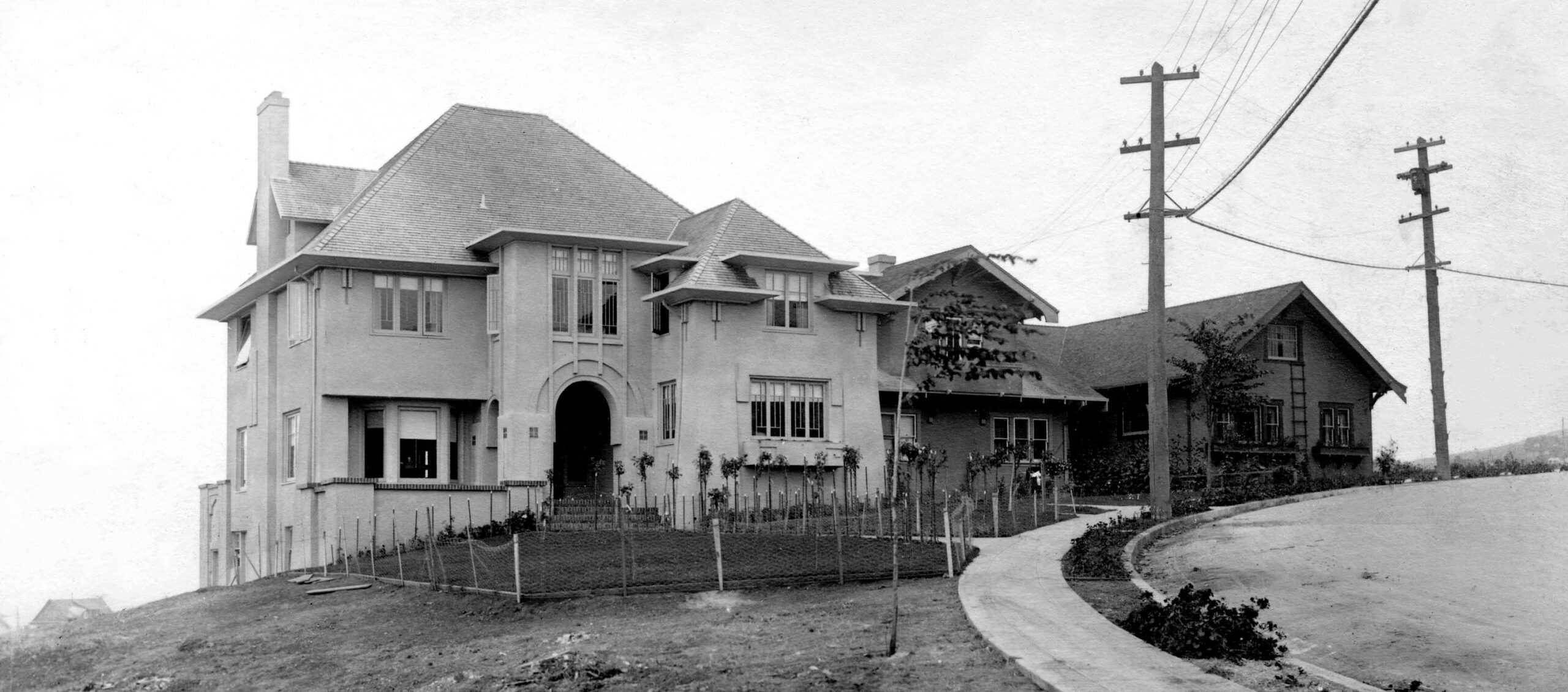
Another example of a house built by John Hudson Thomas in 1913 at no. 1130 Shattuck Ave. has maintained its original architectural features in 2026. Appreciation and acknowledgement to Berkeley architectural historian Daniella Thompson for providing information about the Thomas-designed houses.
L346-30-Sappers Collection, Courtesy BAERA, Western Railway Museum Archives, 252329bv, (Image 7 of 33)
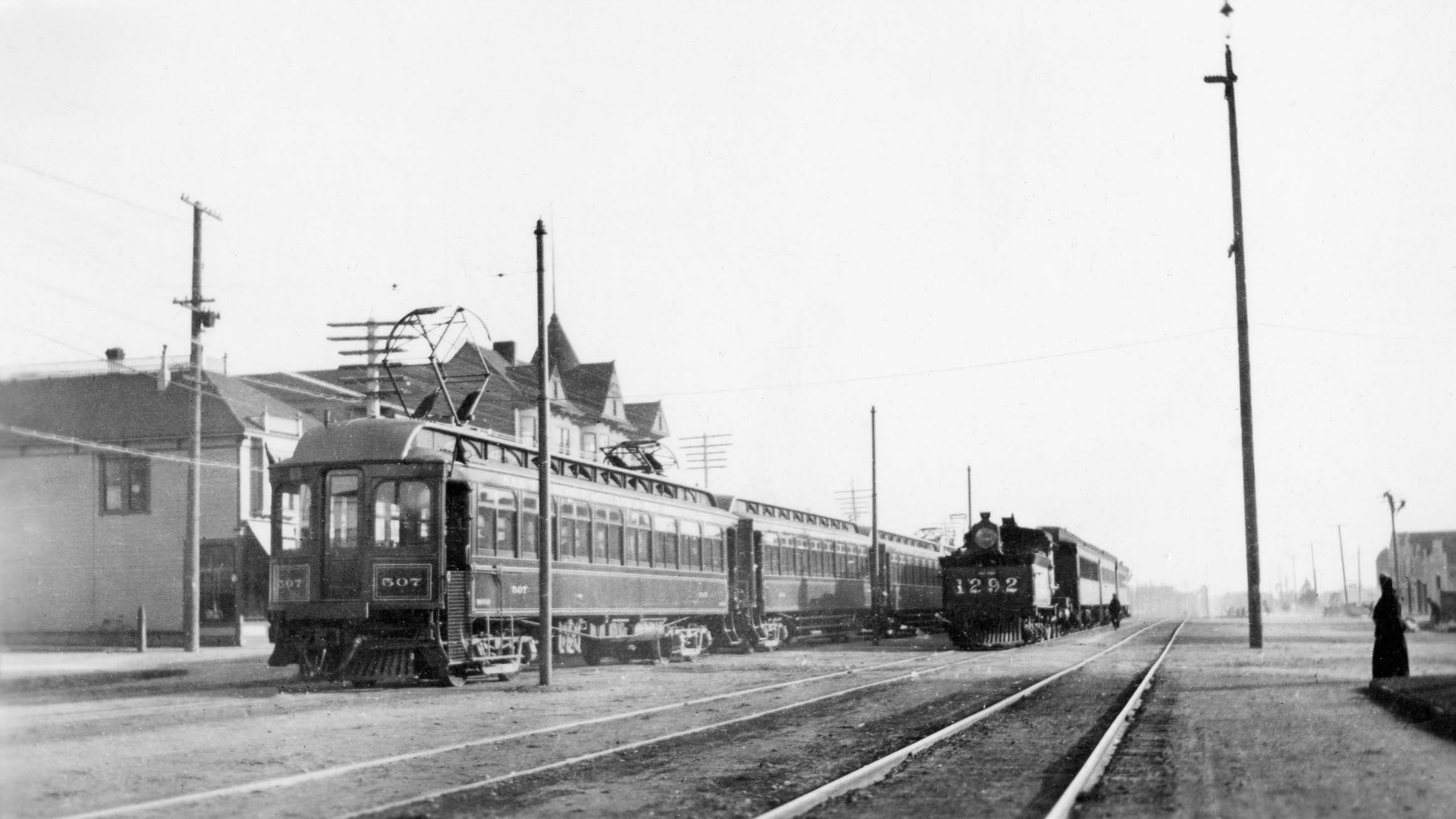
Next to start a thorough review of where the Key and SP Shattuck electric lines directly competed to Northbrae in 1912. As a reminder, the competition on Adeline St. and Shattuck Ave. to University Ave. actually began on Oct. 26, 1903, but that was between the SP steam line shown here with SP 1292 leading with its tender in front versus the faster, cleaner and lower fare of the Key 507-led electric passenger train. This south view was labeled as near Dwight Way ca. 1908, but none of these buildings exist in 2026 to verify this.
L346-35-Ted Wurm Collection, Courtesy BAERA, Western Railway Museum Archives, 198816ks, (Image 8 of 33)
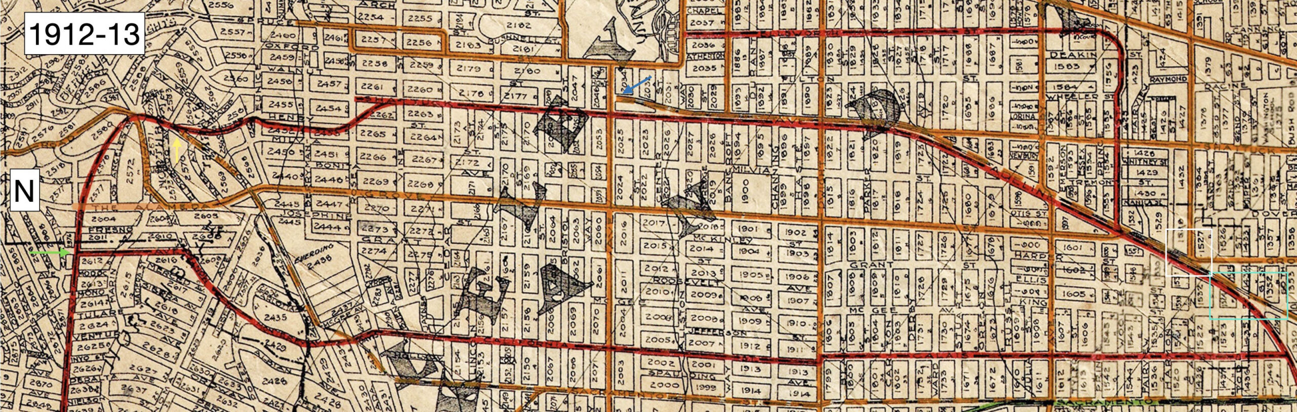
On this 1912-13 map, broken orange lines are Key interurban lines, solid orange lines are streetcars, and red lines are SP OA&B suburban lines. Starting in the south, the two Shattuck lines met just past the Oakland border at Adeline St. and 62nd St. in Berkeley, turquoise box. Although the Key Shattuck line ended at University Ave., blue arrow, it used different lines to compete with the SP to Thousand Oaks, green arrow. The color-coded boxes and arrows on this 1912-13 map will be used in the detailed track diagrams to follow.
L346-40-Realty Bonds and Finance Co. Map of Oakland and Vicinity, Courtesy John Bosko, (Image 9 of 33)
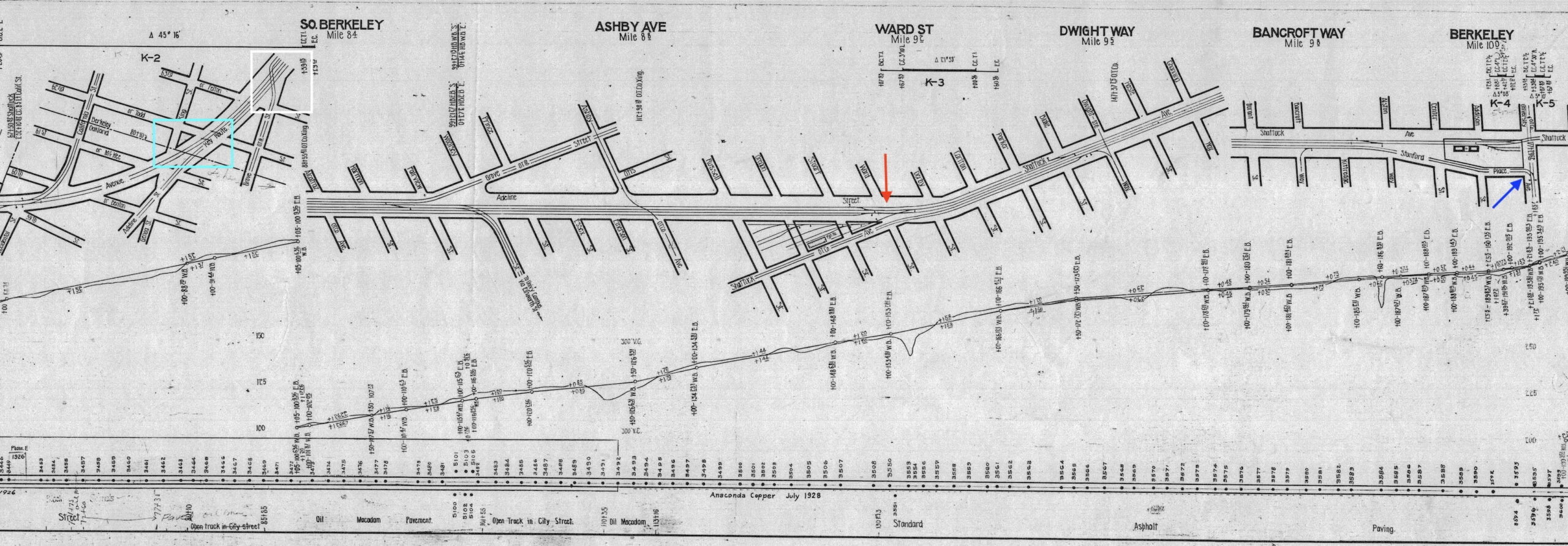
Presented here is a small portion of a map produced by the SP that contained the track diagram and ground elevation for its electric passenger and steam freight operations along Shattuck Ave. in Mar. 1917 (the dates from the 1920s are for overhead wire details that were added later.) Color-coded to match the 1912-13 map with one addition at Ward St., red arrow, the first part to review will be where the two lines met at Adeline St. and 62nd St, turquoise box. One thing to note, the line continued to gain elevation as it headed north, the dips in the elevation of the landscape having been leveled by the road bed.
L346-45-Courtesy BAERA, Western Railway Museum Archives, (Image 10 of 33)
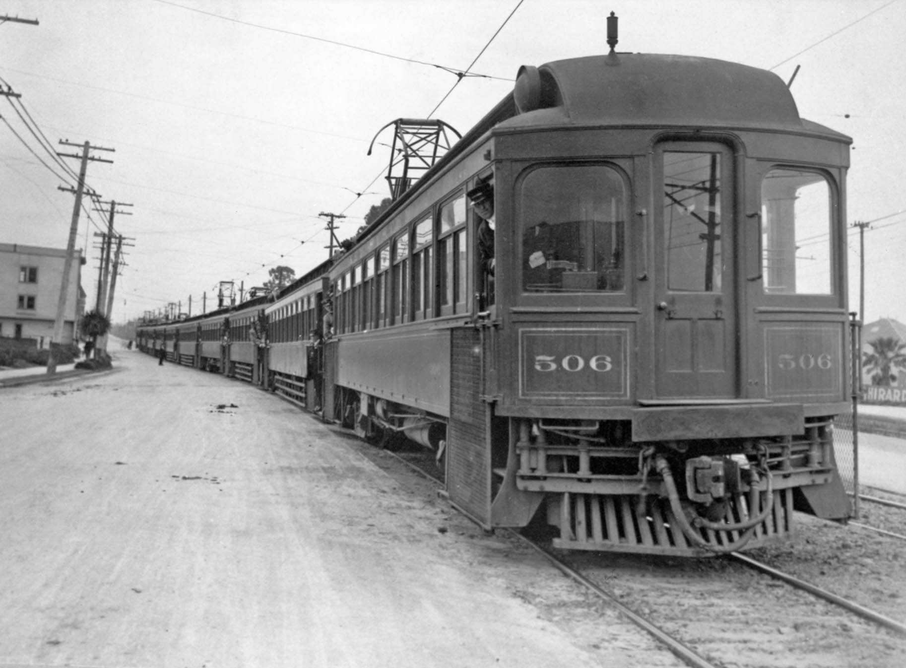
This southwest view features a ten-car Key train on Adeline St. just past 62nd St. led by KS 506. The SP Shattuck line tracks on its private right-of-way, ROW, and the overhead catenary system can be appreciated along the right margin in front of the Ghirardelli sign. The significance of this image is that it shows U.C. Berkeley cadets on their way back from the 1915 Panama-Pacific International Exposition in San Francisco, held in commemoration of the opening of the Panama Canal. This compulsory cadet program would evolve into an ROTC program on the campus.
L346-50-W. E. Gardnier Photo, Sappers Collection, Courtesy BAERA, Western Railway Museum Archives, 85758ks, (Image 11 of 33)
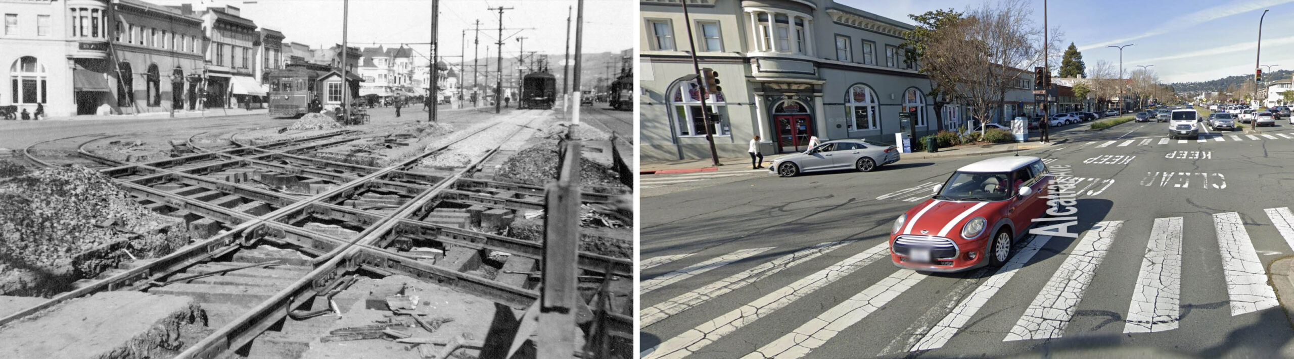
Next to the area surrounded by the white box. On the left, further along Adeline St. just short of Alcatraz Ave. the tracks from the Grove St. streetcar crossed both the Key and SP tracks as seen on the left where repair of those crossings was in progress in this north view from Nov. 1921. Note the SP train to the left and the Key train to the right in the distance at the South Berkeley stop. The architecture of the buildings on the west side of Adeline St. north of Alcatraz Ave. has not changed much in the last 100 years as documented via an image taken from Google Maps on the right.
L346-55-Key Official Photo, Sappers Colection, Courtesy Western Railway Museum Archives, 78650ks, l, Google Maps Photo, r, (Image 12 of 33)
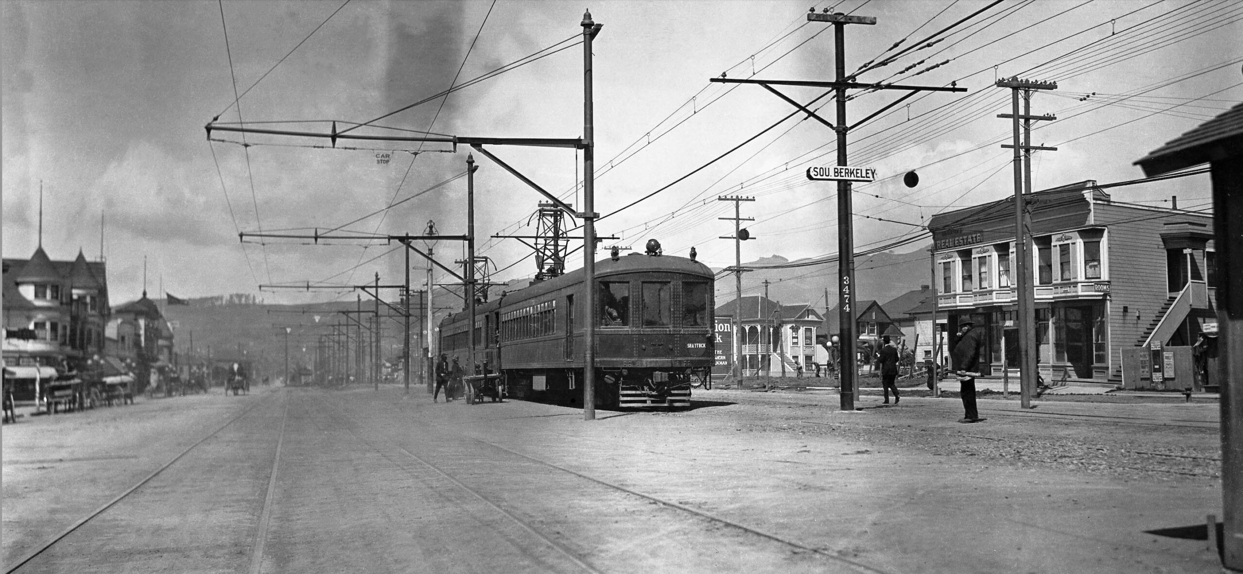
Across Alcatraz St. and back to ca. 1912, this northeast view taken from the Grove St. streetcar tracks toward Harmon St. shows a 600 series baggage-coach motor car SP Shattuck train present at the South Berkeley stop, often referred to as Lorin for the neighborhood, or later by the Key as Alcatraz Ave. The first set of buildings on the left or west side of Adeline St. are still present in 2026, while the structure on the east side or right of the train as well as the houses seen on Harmon St. have been replaced.
L346-60-SP Official Photo, Sappers Collection, Courtesy BAERA, Western Railway Museum Archives 55518oab, (Image 13 of 33)
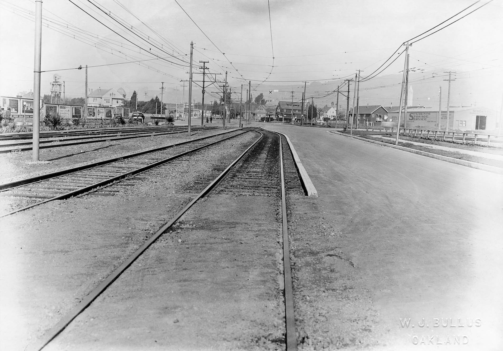
At Ward St., the track arrangement for both lines was complicated by the addition of the Shattuck streetcar with the Key line as the latter was reduced to one track, and a spur sent from the SP crossed the Key line to a freight house and yard bordered by Ward St., Russell St., Shattuck Ave. and Adeline St. Other than the Campanile seen on the right against the background of the hills, no structures in this image appear to have survived to 2026. Northeast view, ca. 1915.
L346-65-W. J. Bullus Photo, Sappers Collection, Courtesy BAERA, Western Railway Museum Archives, 246086ks, (Image 14 of 33)
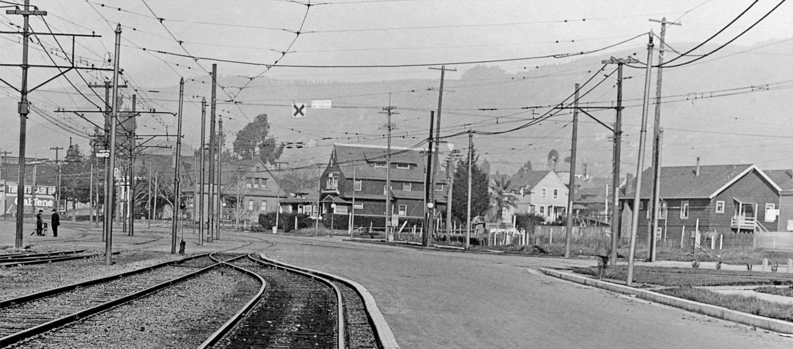
In this detail of the previous northeast view toward Ward St., a tangle of tracks and overhead wire can be better appreciated.
L346-70-W. J. Bullus Photo, Sappers Collection, Courtesy BAERA, Western Railway Museum Archives, 246086ks, Detail, (Image 15 of 33)
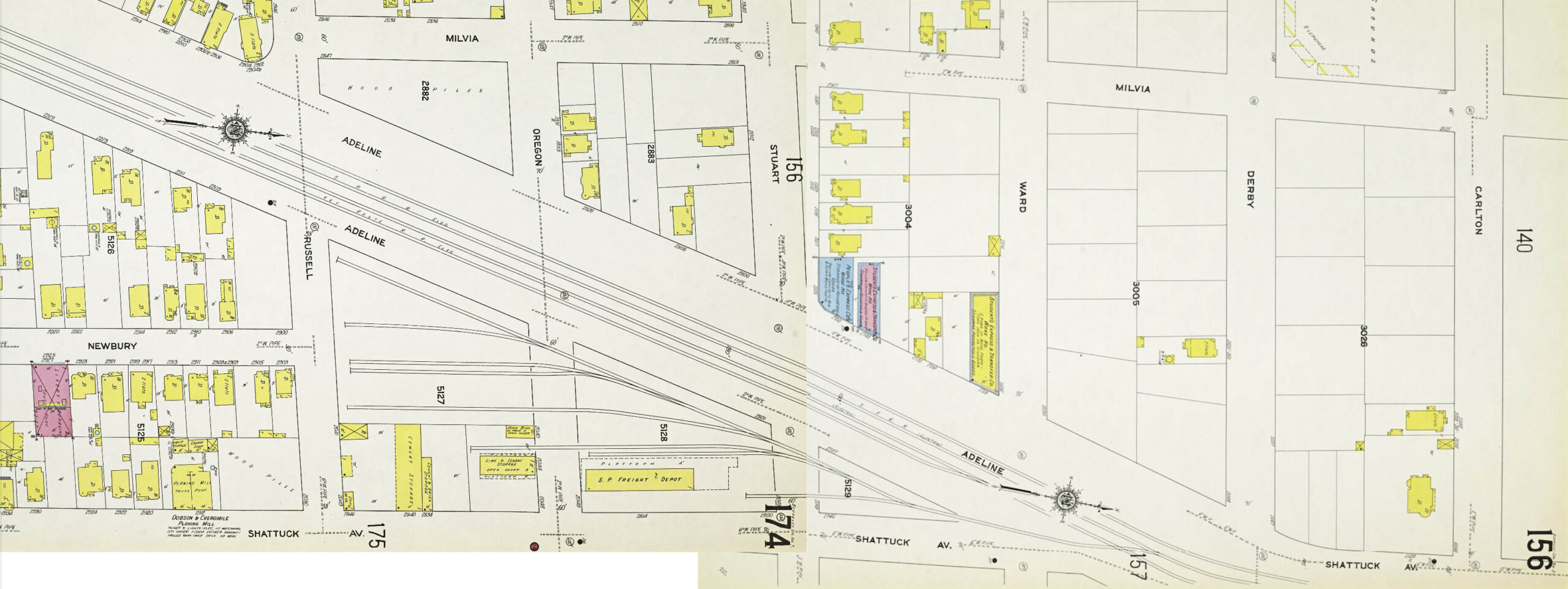
This composite Sanborn map from 1911 confirms the track arrangement for the SP yard and freight house between Ward and Russell Sts. shown previously. In 2026, starting at Russell St. and heading north, these lots now contain the Berkeley Bowl, Walgreens, and the lot for Berkeley Honda.
L346-75-Courtesy Library of Congress, Geography and Map Division, Sanborn Maps Collection, Sanborn Map Company, 1911; Vol. 2 Panel 156, (Image 16 of 33)
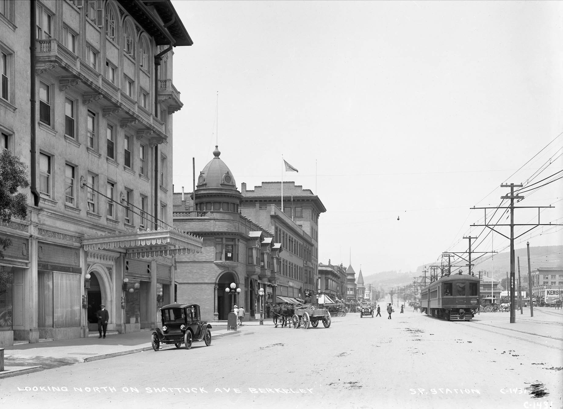
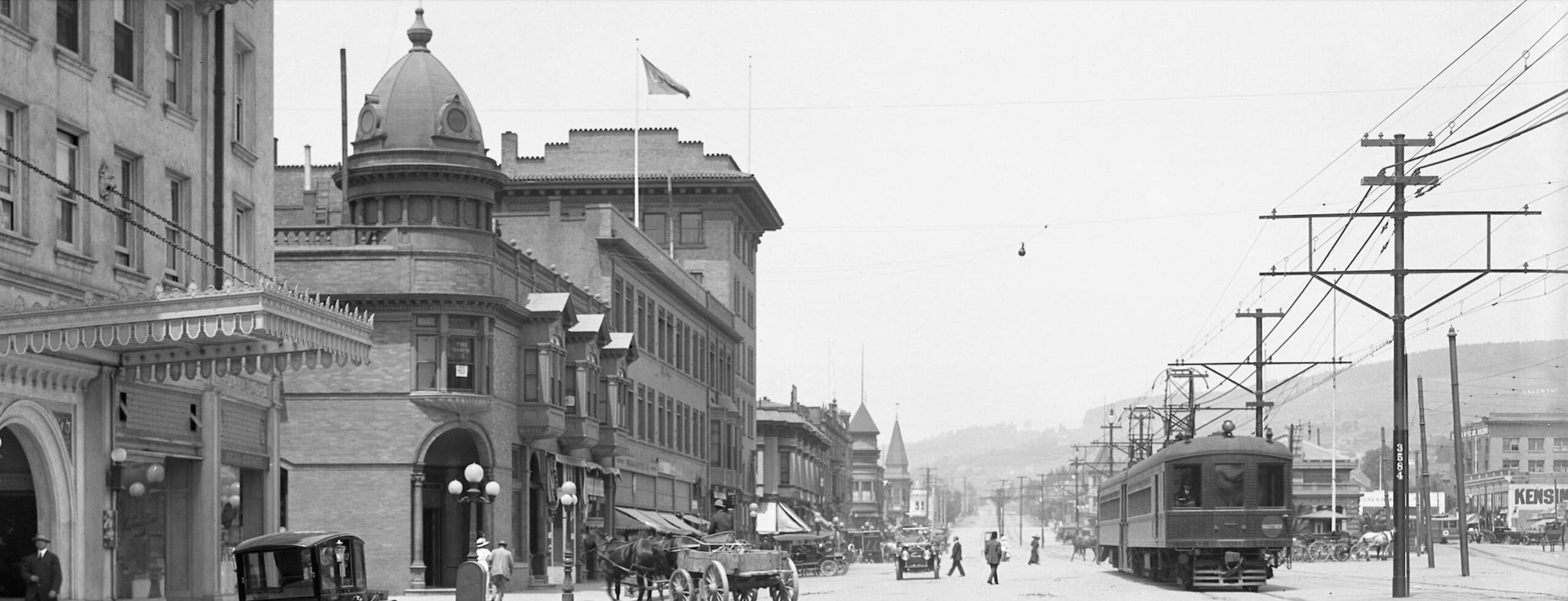
Further north, an SP train that has left the downtown Berkeley station can be seen in this north view ca. 1912 or later. The north end of the Shattuck Hotel at Shattuck Ave. and Allston Way is seen along the left edge, all the other structures north of here are gone in 2026. The Mission Revival-style hotel was designed by San Francisco architect Benjamin McDougall and dates to 1910. McDougall and his firm McDougall Bros. also designed The Cathedral Building in Oakland, originally named the Federal Realty Building. Note the Cheney Photo Advertising Company symbol has been defaced on this glass negative.
L346-80-Eston Cheney Photo C-1431, Sappers Collection, Courtesy BAERA, Western Railway Museum Archives, 22395sp, (Image 17 of 33)
Eston Cheney’s glass negatives have excellent resolving power, so over the next several updates, enlarging interesting structural or physical features that appear in the background will be provided. A detail from the previous north view shows buildings that have long been replaced.
L346-85-Eston Cheney Photo C-1431, Sappers Collection, Courtesy BAERA, Western Railway Museum Archives, 22395sp, Detail, (Image 18 of 33)
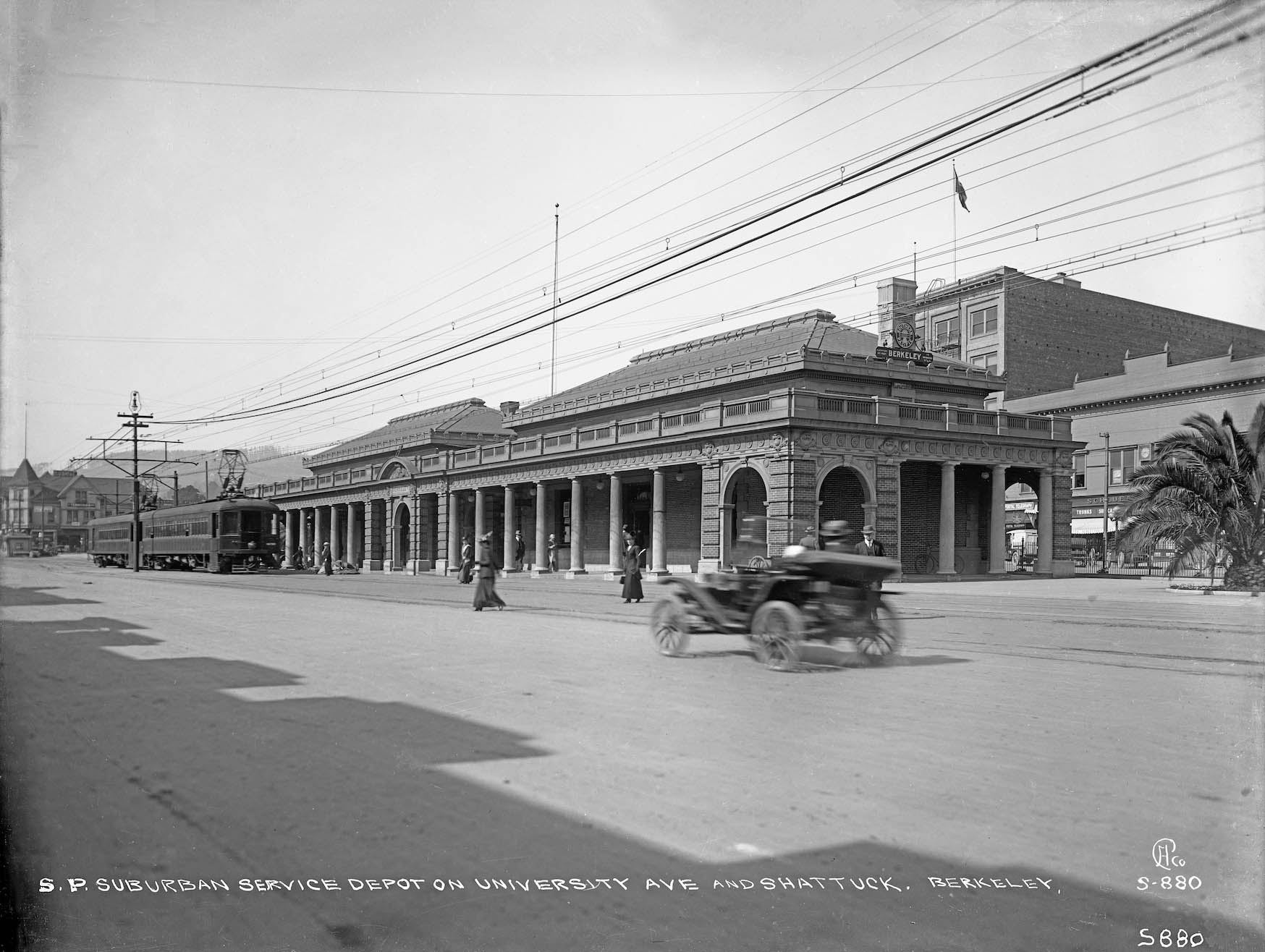
The impressive downtown Berkeley SP station built in 1907 is shown here in the early 1910s with an OA&B electric in this northeast view with a touring car to boot. After many years of attempting to decipher Cheney’s image numbering, it is still not understood what they tell you about the date or location of the photo.
L346-90-Eston Cheney Photo S-880, Sappers Collection, Courtesy BAERA, Western Railway Museum Archives, 22386sp, (Image 19 of 33)
A detail from the previous image shows buildings no longer present in 2026 along University Ave. Note the “07” above the station entrance.
L346-95-Eston Cheney Photo S-880, Sappers Collection, Courtesy BAERA, Western Railway Museum Archives, 22386sp, Detail, (Image 20 of 33)
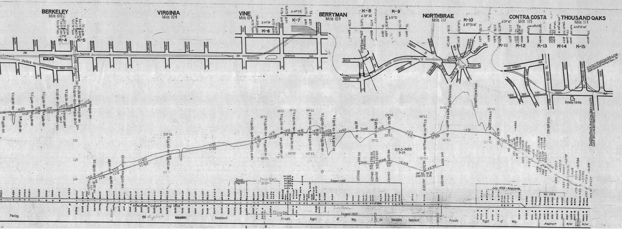
For the SP, the path to Northbrae continued uninterrupted as shown here in the next small portion of a map produced by the SP that contained the track diagram and ground elevation for its electric passenger and steam freight operations past University Ave. in Mar. 1917. The center of the diagram shows the yard built at Berryman for which no image from the 1910s could be found. Note the ROW continued to gain elevation until the tunnel at Northbrae.
L346-100-Courtesy BAERA, Western Railway Museum Archives, (Image 21 of 33)
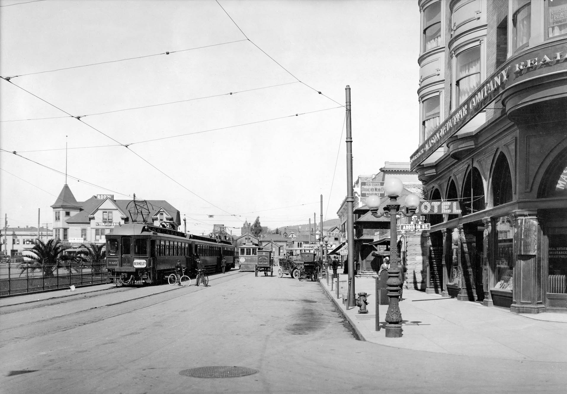
A Key interurban train led by Key 540 and streetcar sit by the Key Berkeley downtown station in the early 1910s. As this north photo reveals, this is the end of the road for the interurban as there was no passage beyond University Ave. Next to explain how the Key planned to compete against the SP trains heading to Northbrae and eventually Thousand Oaks.
L346-105-Sappers Collection, Courtesy BAERA, Western Railway Museum Archives, 20208ks, (Image 22 of 33)
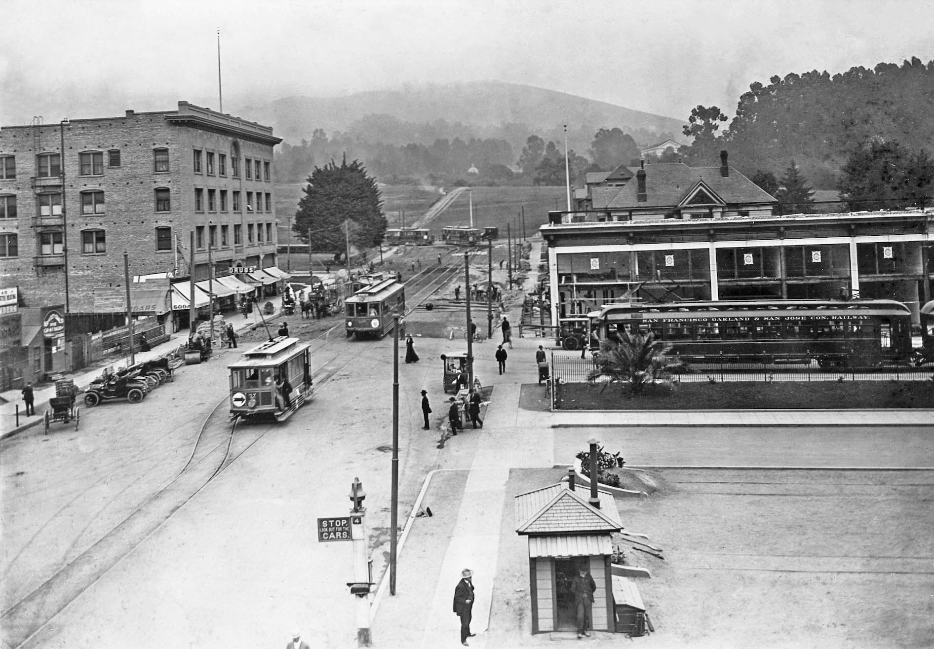
One way to counter the SP route, was to provide street cars in sync with arriving interurbans that would head north up Grove St. to the Circle and to Thousand Oaks. The other possibility was its Northbrae line. This east view at University Ave. and Shattuck Ave shows the numerous streetcars on University Ave. The Acheson Physicians building seen here with the “Drugs” sign from one of its ground floor businesses was built in 1909 and still looks great in 2026.
L346-110-Louis L. Stein Collection, Courtesy BAERA, Western Railway Museum Archives, 50240ks, (Image 23 of 33)
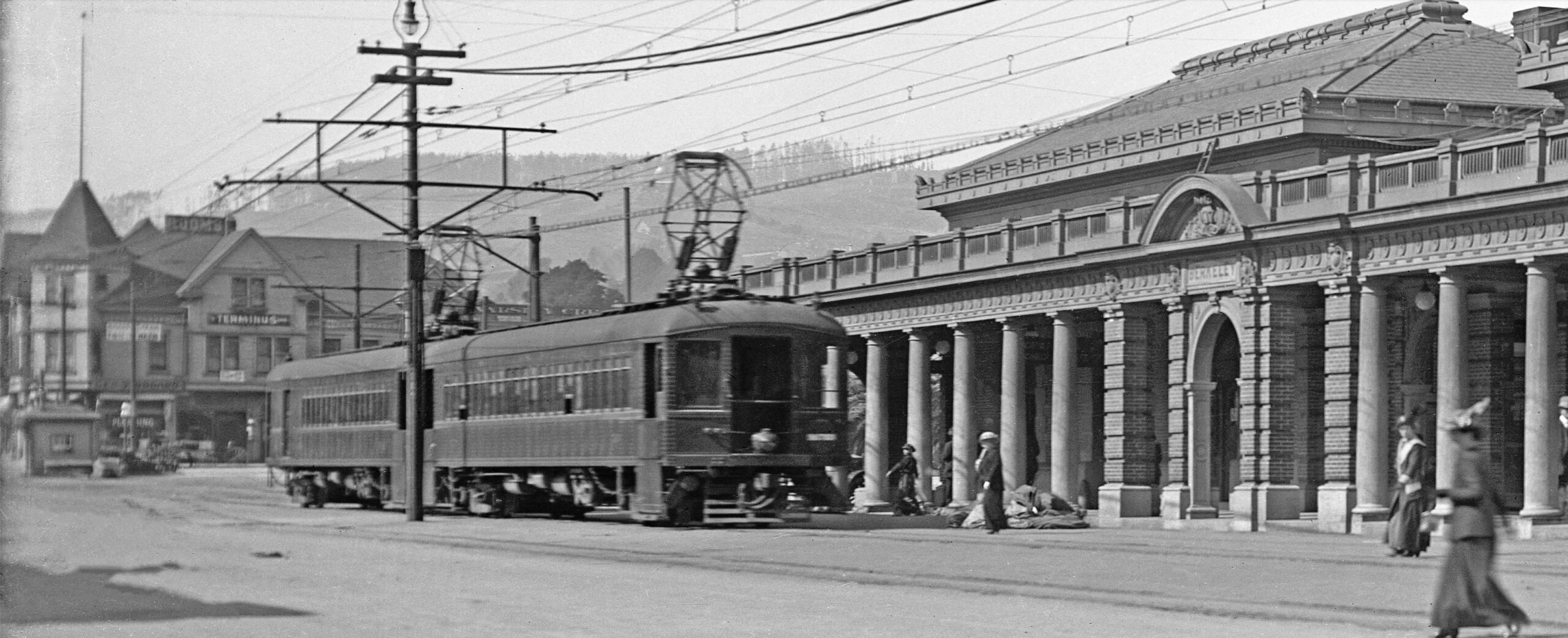
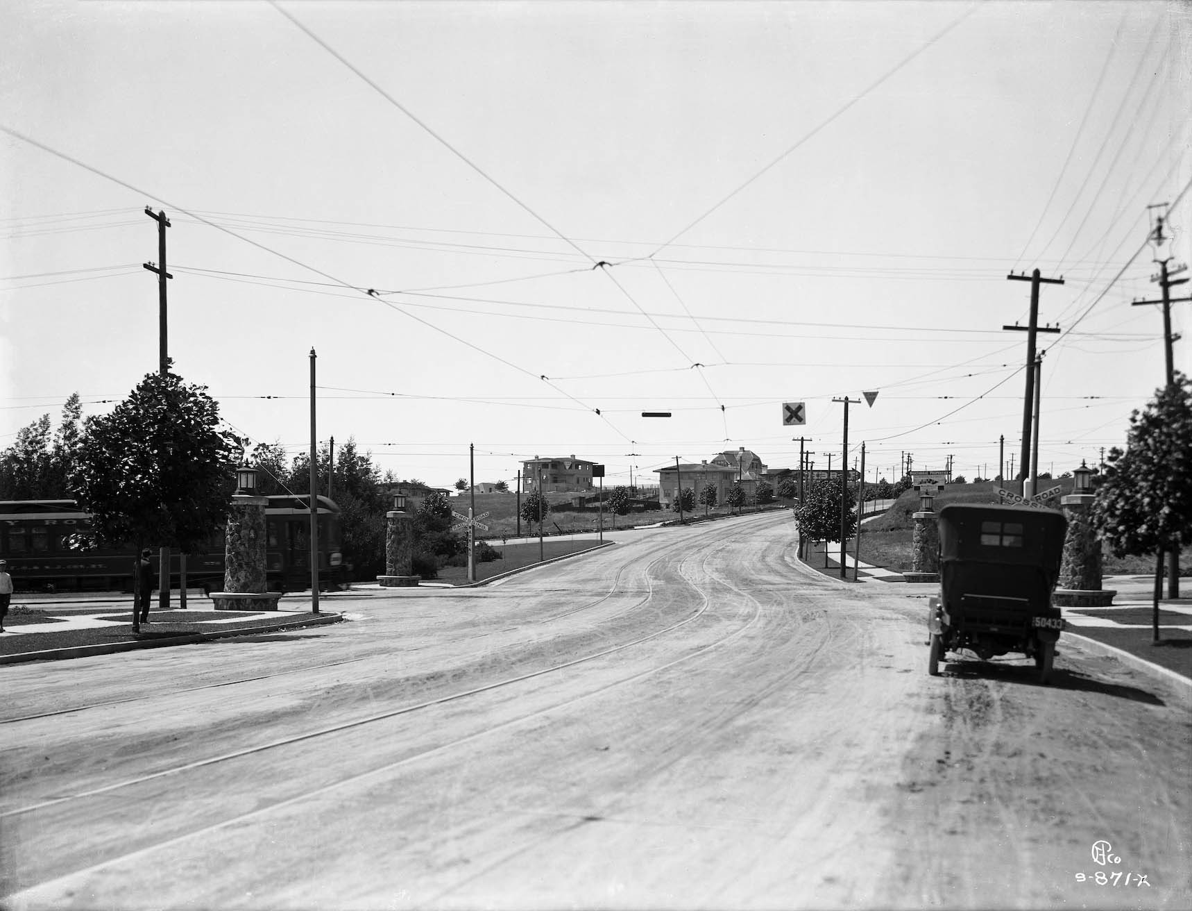
Yet another Cheney photo shown here, this one is a north view up The Alameda at Hopkins St. Beginning Apr. 12, 1912, these streetcars tracks would go up Marin Ave. to the Circle or continue to Solano Ave. and end two blocks from the SP Thousand Oaks terminal according to Vernon Sappers. Also, the Northbrae train seen here could have brought passengers from Key Pier where they could transfer to these streetcars. Independent of the Cheney number, the year is 1914 based on the license plate on the car. The North Berkeley Public Library sits on the triangular piece of land to the right of the train in 2026.
L346-115-Eston Cheney Photo S-871-X, Sappers Collection, Courtesy BAERA, Western Railway Museum Archives, 17751oa&b, (Image 24 of 33)
A detail from the previous north view shows some of the houses in the area. These houses have either been extensively modified or replaced based on what exists on these lots in 2026.
L346-120-Eston Cheney Photo S-871-X, Sappers Collection, Courtesy BAERA, Western Railway Museum Archives, 17751oa&b, Detail, (Image 25 of 33)
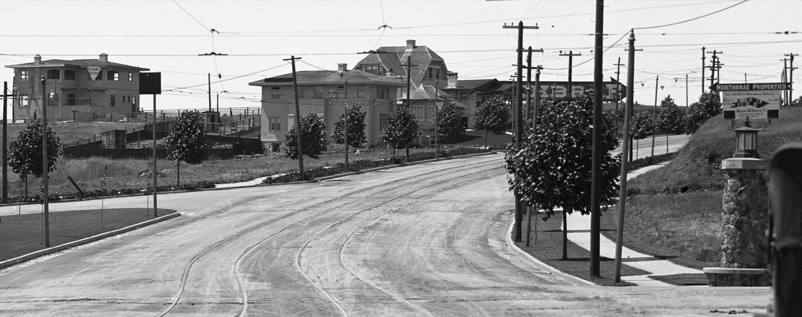
This north view at The Circle must have been taken around 1911, that is, after the SP tunnel was finished, and before the tracks and overhead wire for the northern-bound lane of Arlington Ave. seen at the right edge were added. The street heading uphill is Indian Rock Ave.
L346-125-Key VPO Photo, Sappers Collection, Courtesy BAERA, Western Railway Museum Archives, 55508ks, (Image 26 of 33)
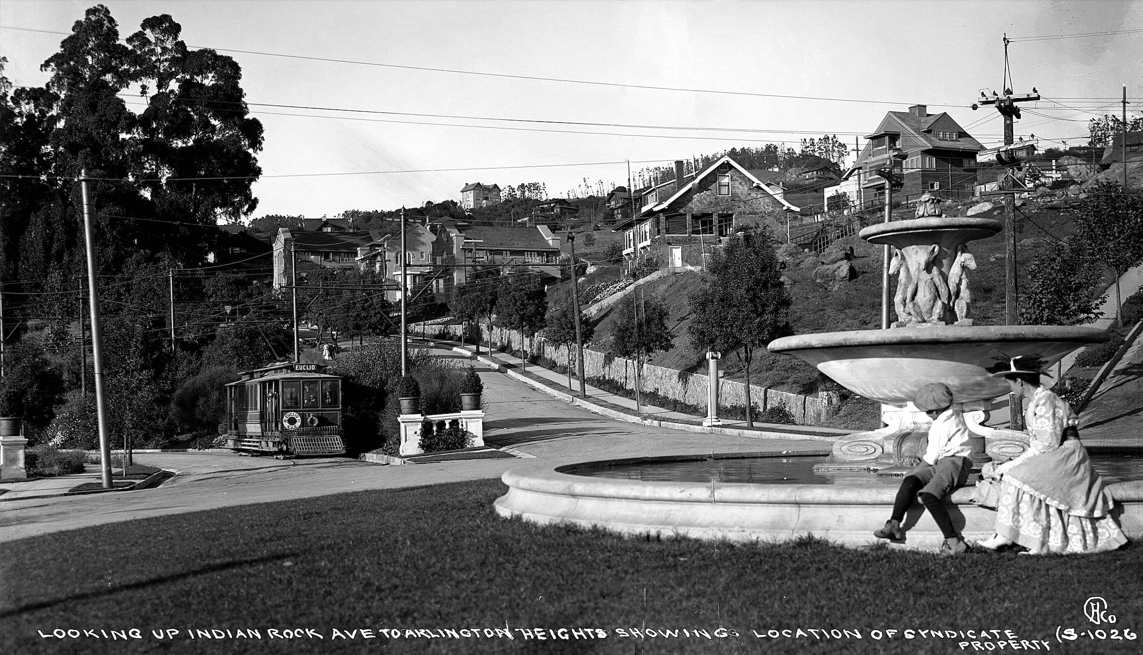
By the time this image was taken by Cheney, the Euclid and Arlington lines had been combined to handle both Arlington Ave. and Thousand Oaks according to Sappers. That occurred on May 31, 1912, although relative to other Cheney “S” numbers presented so far, this image should have been taken taken after the one shown previously from 1914. It is not clear what Cheney meant by “Syndicate”, but it was not referring to the Realty Syndicate.
L346-130-Eston Cheney Photo S-1026, Sappers Collection, Courtesy BAERA, Western Railway Museum Archives, 25324ks, (Image 27 of 33)
The Key Northbrae line ran as close to the Circle as the SP Shattuck line. Here in this ca. 1912 south view, the Key car KS 585 waits at its terminus at Hopkins St. and Sutter St. A SP Shattuck train has passed and is now heading for downtown. There appears to be a workman by the switch track, and a horse and buggy following the train.
L346-135-Robert McFarland Photo, Moreau Collection from Erle Hanson Collection, Courtesy BAERA, Western Railway Museum Archives, 22125ks, (Image 28 of 33)
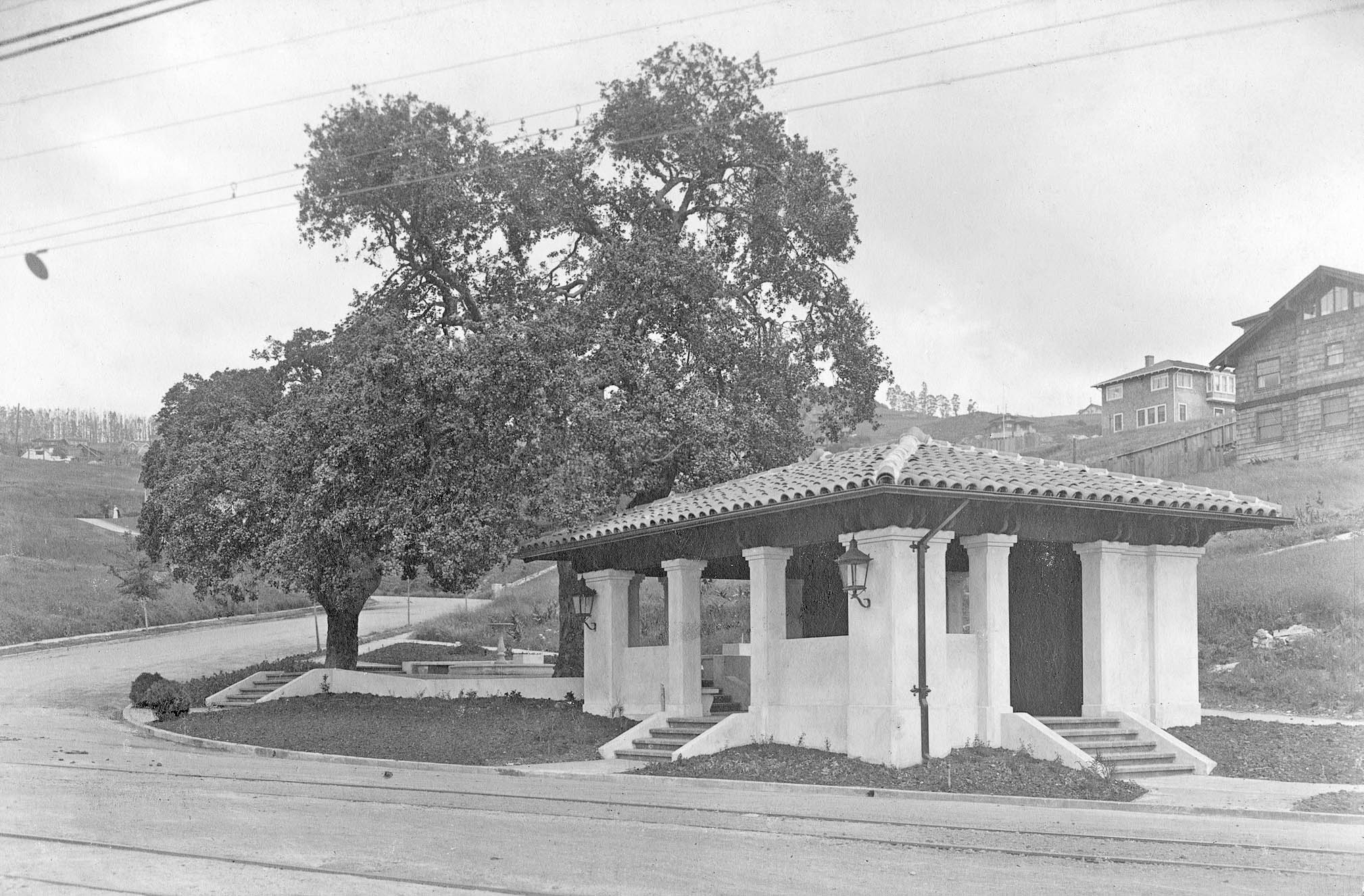
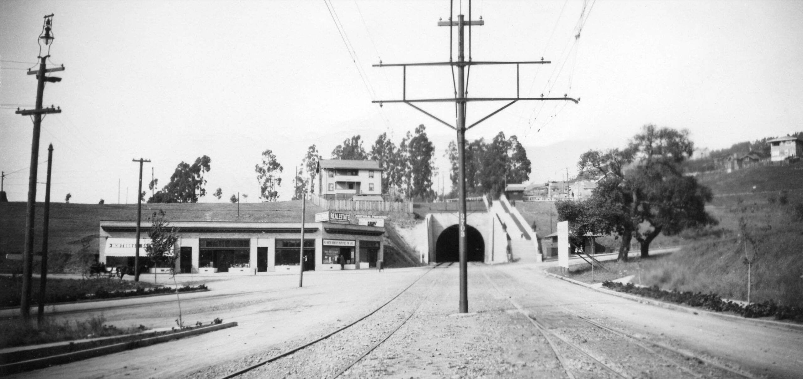
The SP had the shelter shown here in a northeast view built just south of Del Norte St. after 1912.
L346-140-Courtesy BAERA, Western Railway Museum Archives, 177788ks, (Image 29 of 33)
It would appear from this north view from Oct. 16, 1912 that a smaller structure had initially been set up north of Del Norte St. Just a guess, but the billboard to the left of the tree might have been the plans for the successor shelter to come.
L346-145-SP Official Photo, Sappers Collection, Courtesy BAERA, Western Railway Museum Archives, 58644oa&b, (Image 30 of 33)
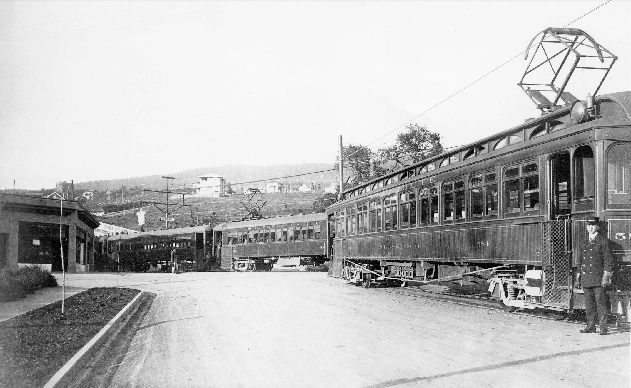
This northeast view from the late 1910s shows a Key 584 waiting empty at the end of Hopkins St. while the SP train heading to the Oakland Pier appears to have several passengers on board in car no. 621.
L346-150-Robert L. Stein Collection, Courtesy BAERA, Western Railway Museum Archives, 22126ks, (Image 31 of 33)
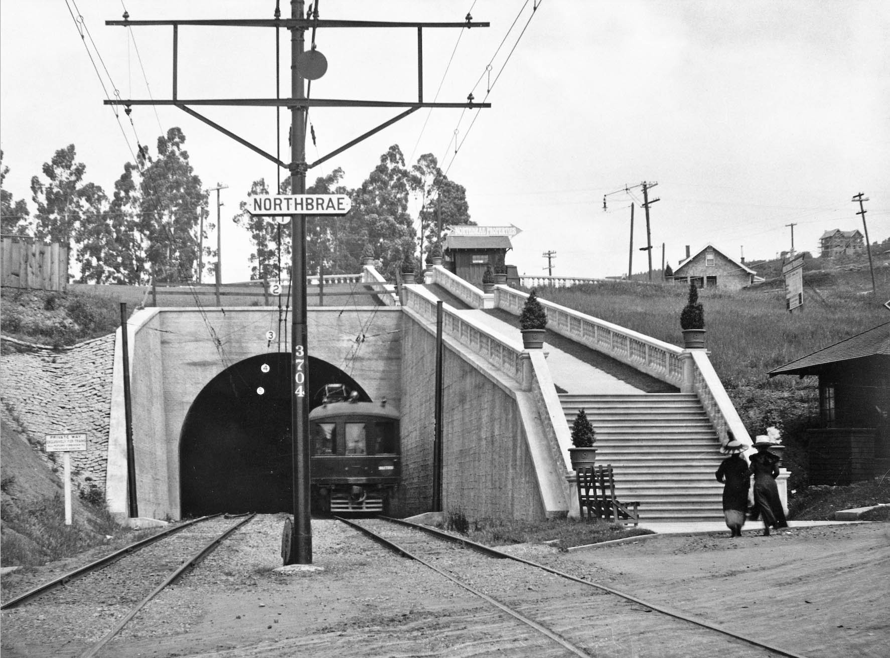
This north view at the Sutter-side portal of the Northbrae Tunnel shows a Shattuck train entering the tunnel on Apr. 27, 1912. At this point the steps to the Circle are finished, and the earlier shelter is positioned close to them. The numbers suspended above the trains provided a guide for where the motorman should position the passenger cars at the Northbrae stop.
L346-155-SP Official Photo, Sappers Collection, Courtesy BAERA, Western Railway Museum Archives, 25730oab, (Image 32 of 33)
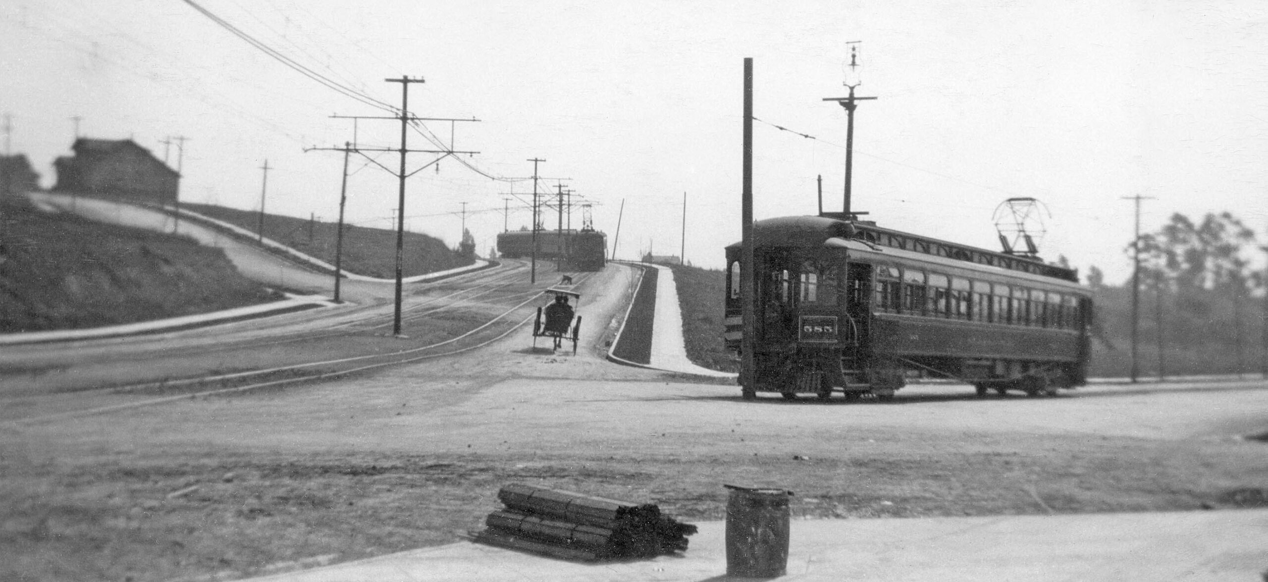
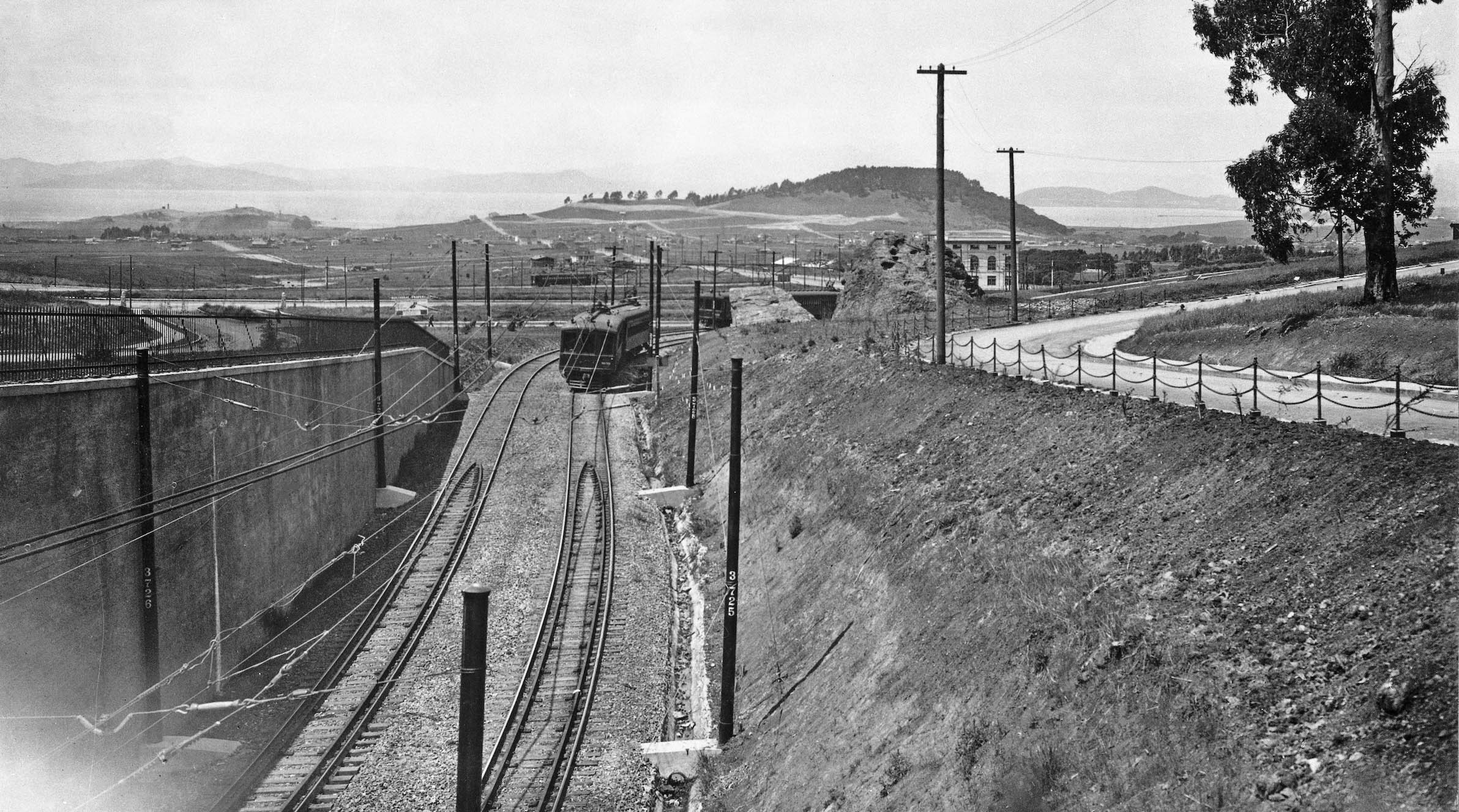
The two car train in the foreground beyond the Northbrae tunnel portal in early 1912 is heading to Thousand Oaks. The next update will focus on that area in the 1910s. Back to the image, along with a Shattuck two-car train heading back to the Oakland Pier, note the California St. train in the distance approaching the Colusa wye.
L346-160-SP Official Photo, Sappers Collection, Courtesy BAERA, Western Railway Museum Archives, 58663oab, (Image 33 of 33)