1912-1920 – Eston Cheney, Real Estate, and Troubles

The previous update focused on the Southern Pacific, SP, Oakland, Alameda and Berkeley, OA&B, suburban railway and the Key System, Key, interurban railway Shattuck lines from 62nd St. to University Ave. in Berkeley, not shown on this map, and between Hopkins St. and the Circle in Northbrae with Key streetcar line, blue box, between 1912-1920. This update will focus on the railway lines along Sacramento, St., California Sts. and Solano Ave., enclosed by the white line, during the same period along with the associated active real estate offerings.
L347-05-Realty Bonds and Finance Co. Map of Oakland and Vicinity, Courtesy John Bosko FINAL, (Image 1 of 30)

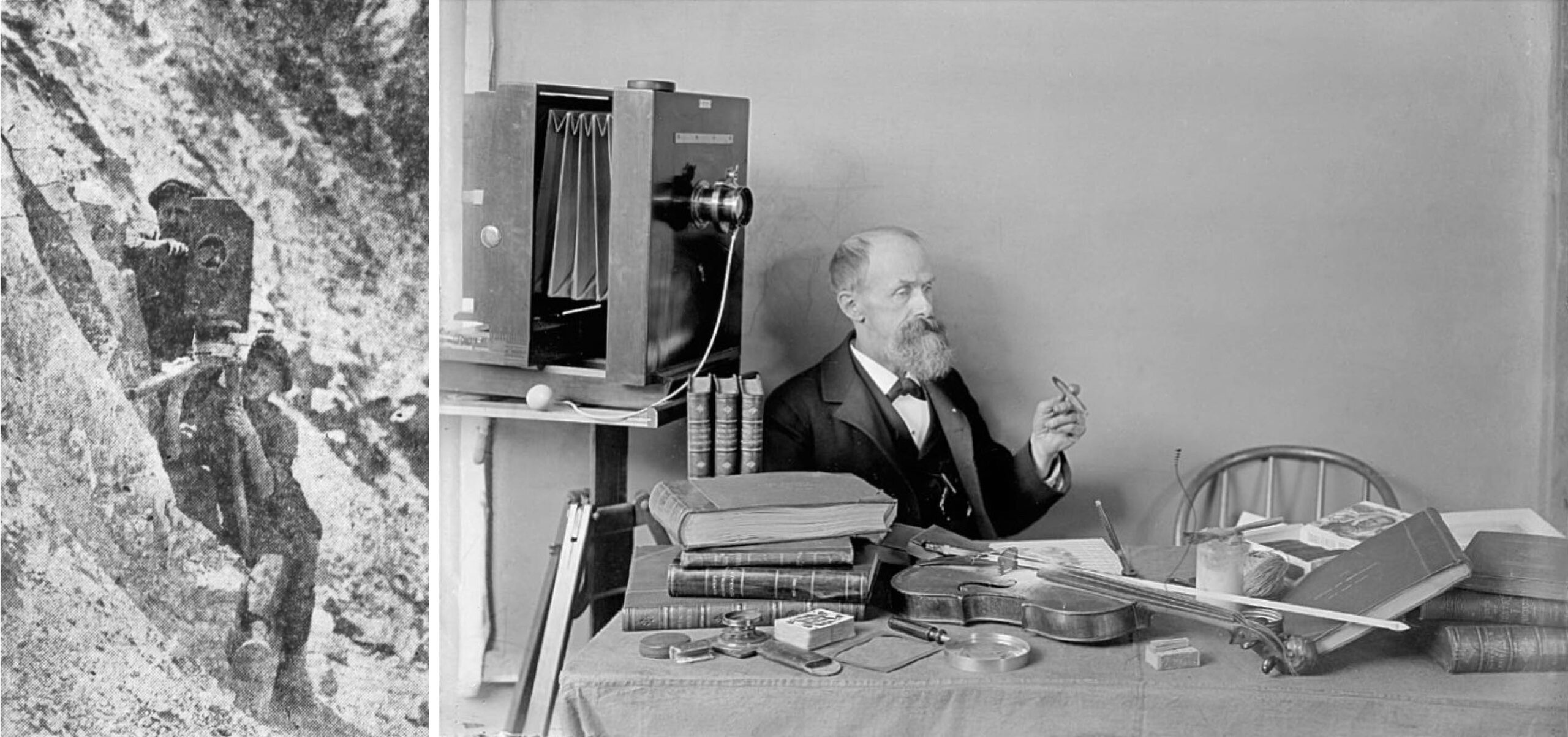
For this update, almost all of the ground images were taken by Eston Saxe Cheney. He was employed by the railways to promote their routes, and by real estate firms to sell lots in the 1910s. A photo of Cheney and son, Eston, Jr., are shown on the left taking images at the Farallones for the Oakland Museum published in the Oct. 3, 1920 Oakland Tribune. The man on the right may also be Cheney, but there is some doubt since the camera shown was not of his patented design. For more on Cheney, click here.
L347-10-Courtesy California Digital Newspaper Collection, University of California Riverside, l, Courtesy Howard Stein, r, (Image 2 of 30)
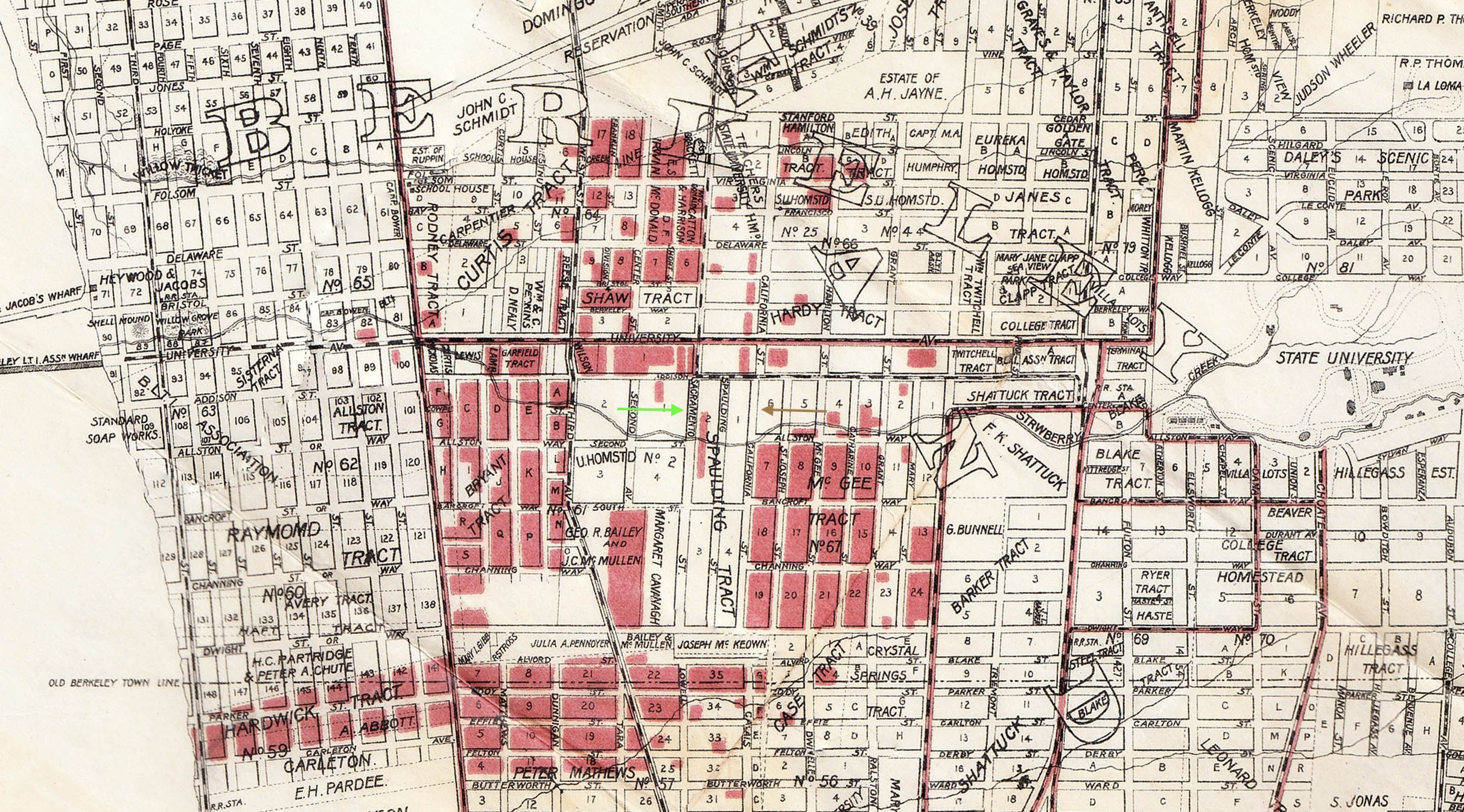
In a previous update in this series, this 1903 map was shown as it included property owned by the Realty Syndicate, shaded in red. The green and brown arrows mark Sacramento St. and California Sts., respectively, where the images to be shown were taken. Cheney was taking photos marked as Cheney Photo Advertising Co. making it at least 1912. The mystery with Cheney’s images is trying to figure out what the letter-number designation for each photo meant as the images were not dated nor the customers identified.
L347-15-Map of Oakland and Vicinity, Published by Woodson, Watson and Co., Courtesy John Bosko, (Image 3 of 30)
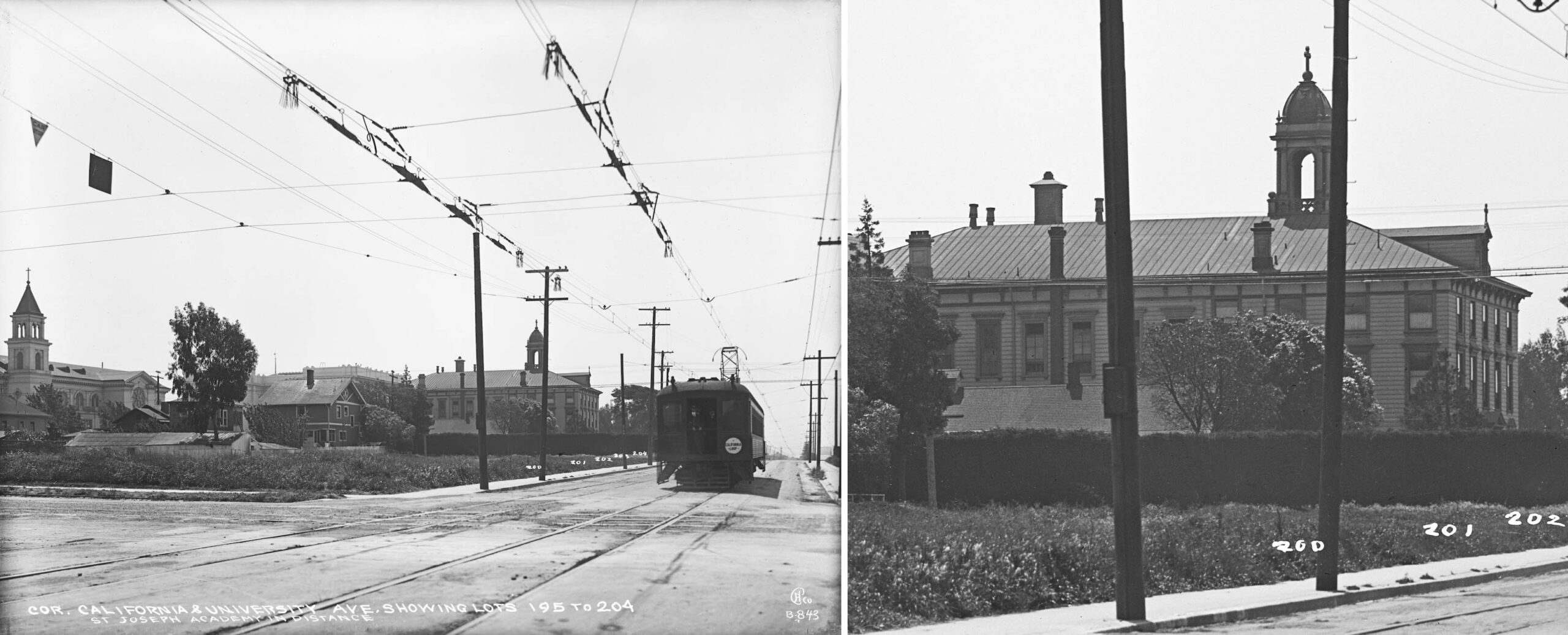
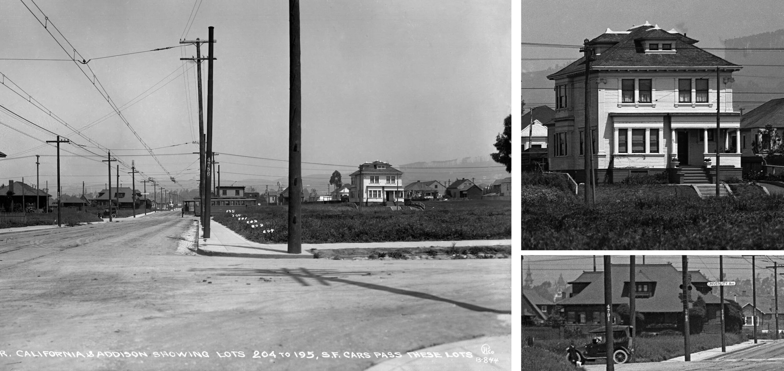
Cheney images that have been found of the SP California St. line at the most southern point begin at University Ave., a southeast view of the intact glass plate on the left, a detail of the St. Joseph Academy and lots for sale on the right. Of the buildings seen in this image, only the the church on the left border in the left panel remains in 2026. Note the designation of the glass plate negative as B-843.
L347-20-Eston Cheney Photo B-843, Sappers Collection, Courtesy BAERA, Western Railway Museum Archives, 22384sp, (Image 4 of 30)
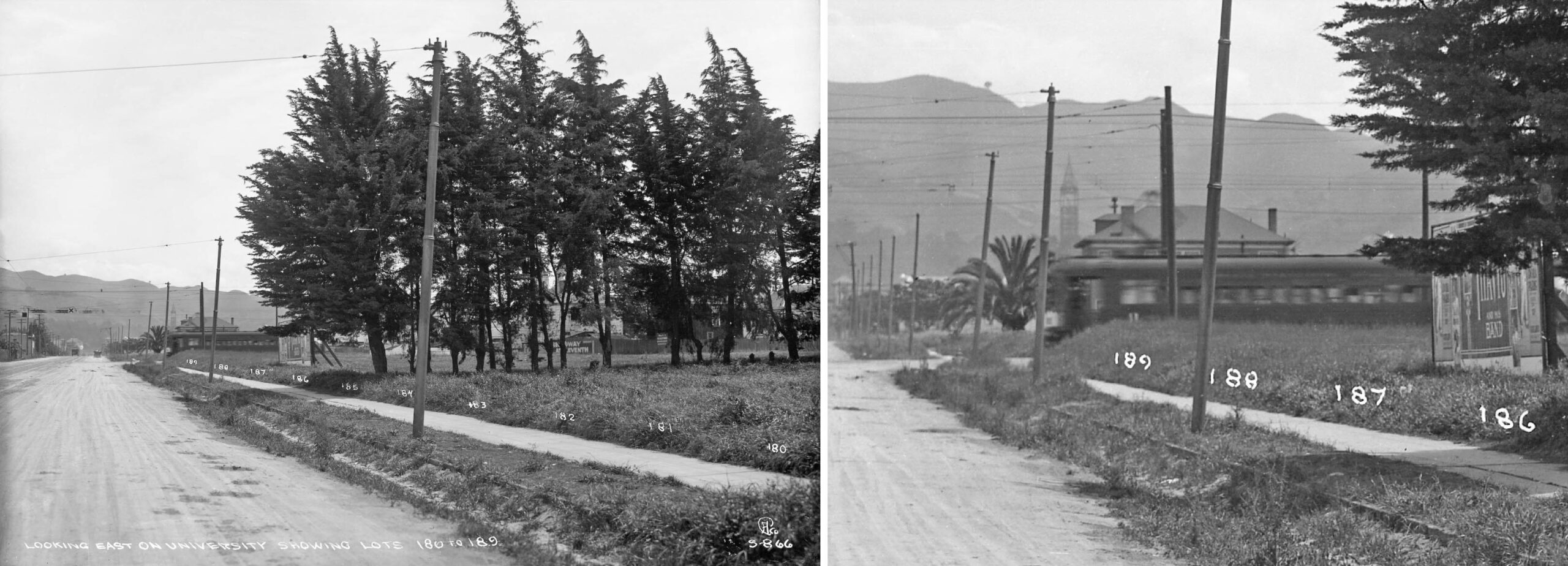
This east view down University Ave. taken just east of Sacramento St. on the left shows more lots for sale, an SP California St. car, and in the distance down University Ave., a streetcar. St. Joseph’s can be made out behind the stand of trees. The detail on the right shows in the distance the steel skeleton of the UC Berkeley Campanile, dating this image to ca. early 1914. This plate was designated S-866.
L347-25-Eston Cheney Photo S-866, Sappers Collection, Courtesy BAERA, Western Railway Museum Archives, 22375oa&b, (Image 5 of 30)
Next looking north on California St. at Addison St., left, a Key streetcar is seen at University Ave. Lots 195-204 are marked, and correspond to those on the 1903 map. Note here Cheney also uses a”B” here along the California St. line, and the 844 number is close to the images in this series as will be confirmed shortly. Two details on the right show two houses that are still present in 2026. First, the large white house, top, is no. 1617 University Ave., the bottom shows no. 1912 California St. at Berkeley Way, the latter painted a light tan in 2026.
L347-30-Eston Cheney Photo B-844, Sappers Collection, Courtesy BAERA, Western Railway Museum Archives, 22376oa&b, (Image 6 of 30)
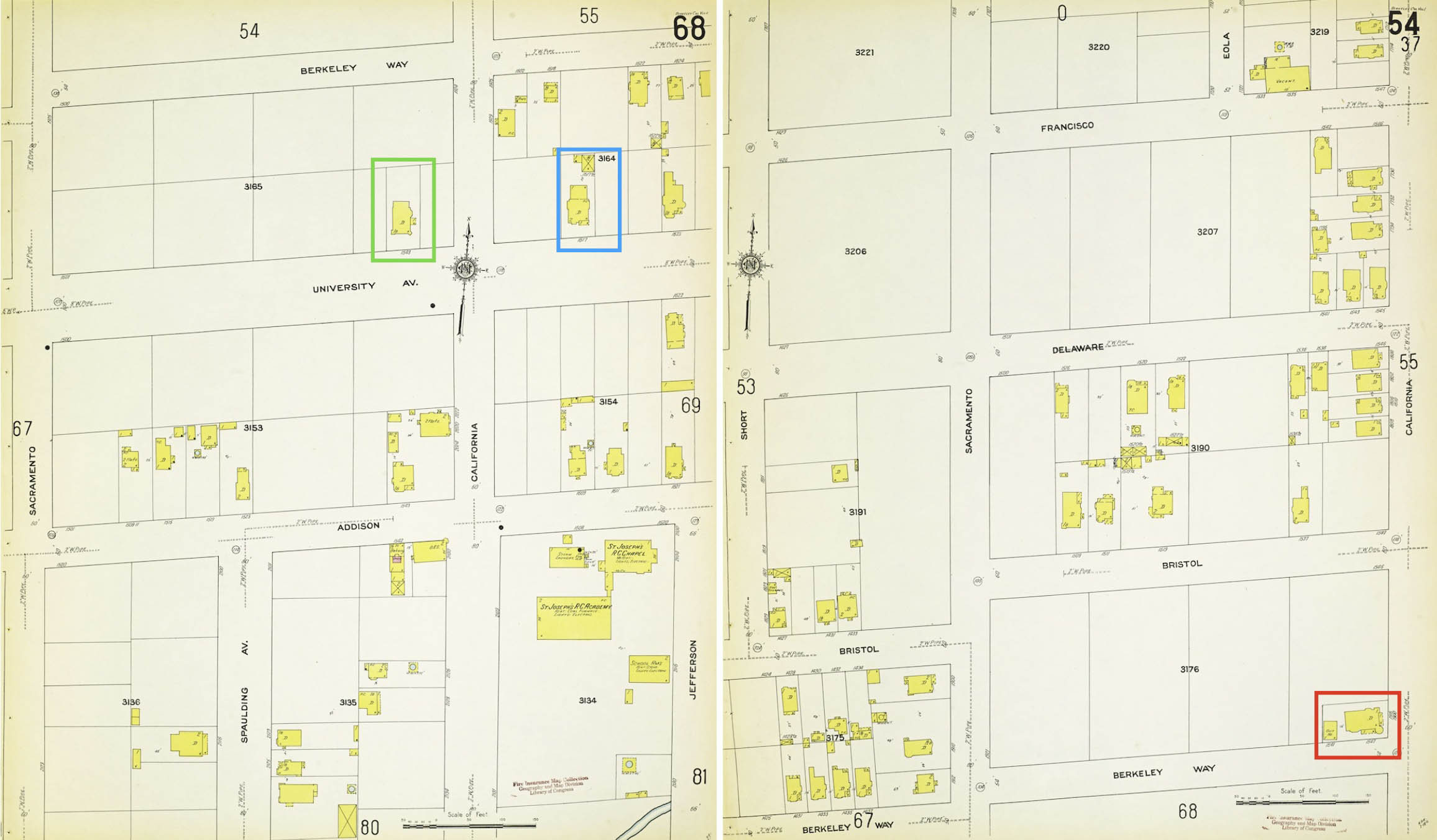
Presented here are Sanborn maps from 1911 showing the area just passed through on the left, and the last coverage of Sacramento St. heading north on the right. On the left, the complex of buildings related with St. Joseph’s are along the bottom right, and no. 1617 University Ave. is boxed in blue. On the right, no. 1912 California St. is boxed in red, with several addresses applied to it, none of which are no. 1912. The house boxed in green will be seen in the next image.
L347-35-Courtesy Library of Congress, Geography and Map Division, Sanborn Map Company, 1911; Vol. 1, Panels 68 and 54, (Image 7 of 30)
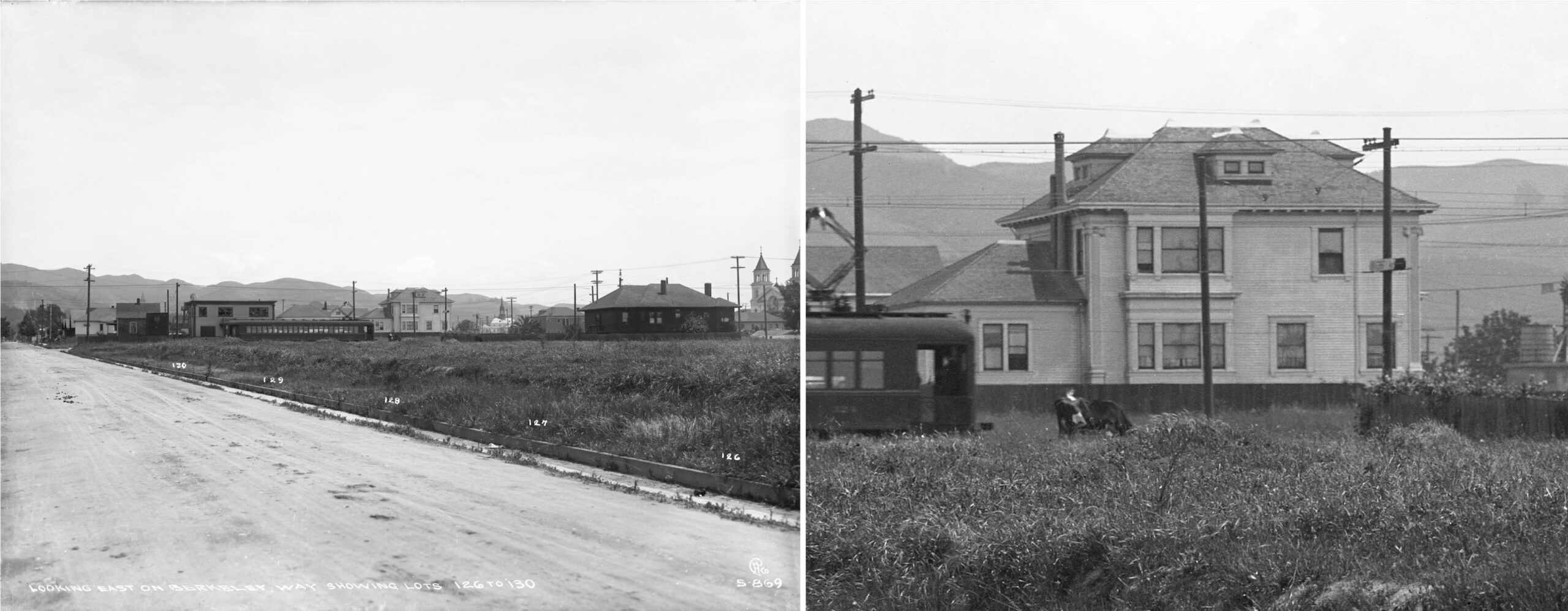
Next an east view up Berkeley Way from a position east of Sacramento St. Cheney is using an “S” in the designation of this glass plate that looks across California St., and as in L347-25, this is an east view. Related to the latter, this image has an “869” attached, close to the “866” ca. 1914 date of L347-25. The dark house on the right border is west of California St. and corresponds to no. 1843 University Ave. boxed in green in the previous Sanborn map, left. On the right shown here is the west-facing side of no. 1617 University Ave.
L347-40-Eston Cheney Photo S-869, Sappers Collection, Courtesy BAERA, Western Railway Museum Archives, 22381oa&b, (Image 8 of 30)
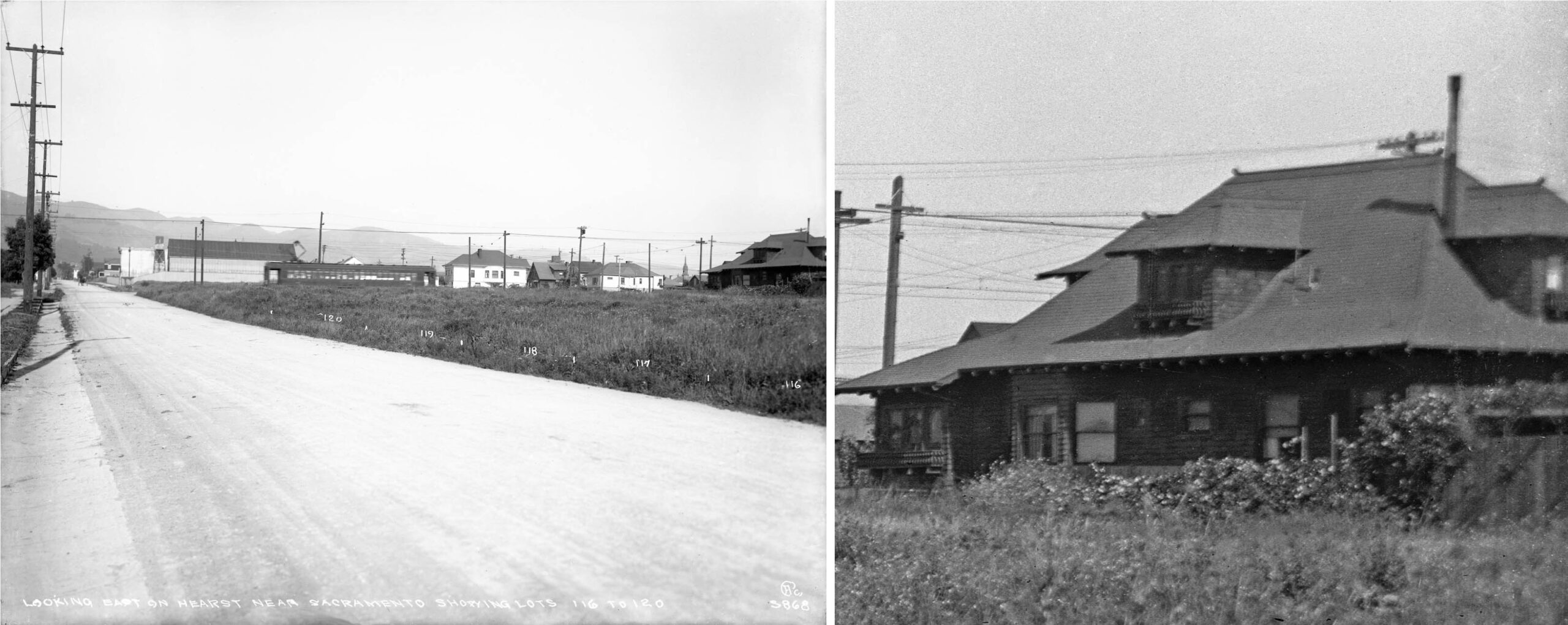
Based on Cheney’s numbering, this one is numerically one less than the last one, and also an east image with an “S” designation, left. He was not following the same train, however, as the raised pantograph contacting the overhead wire is on the opposite side of the train. On the right is a detail of the north-facing side of no. 1912 California St. seen previously.
L347-45-Eston Cheney Photo S-868, Sappers Collection, Courtesy BAERA, Western Railway Museum Archives, 22397oa&b, (Image 9 of 30)
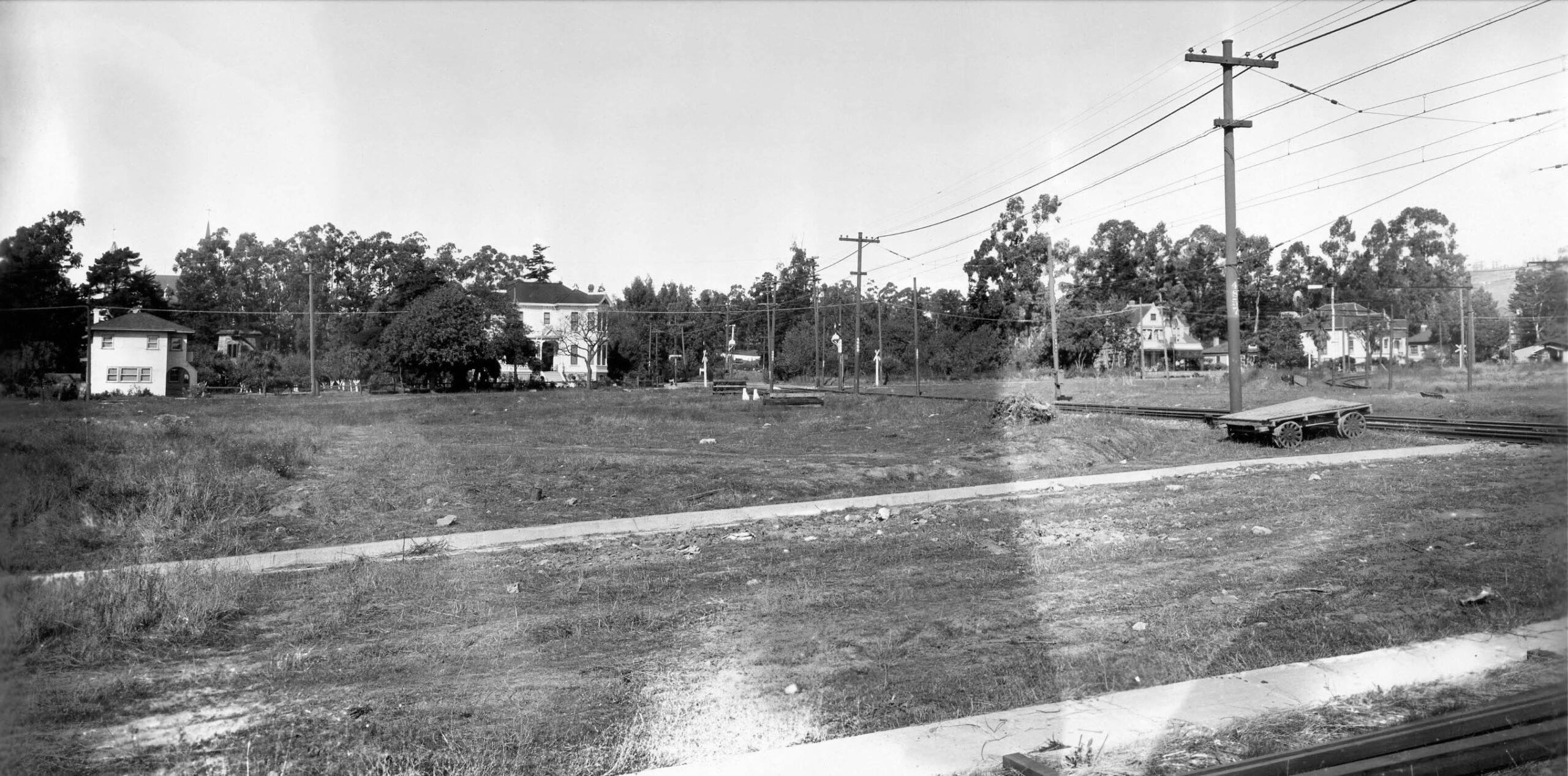
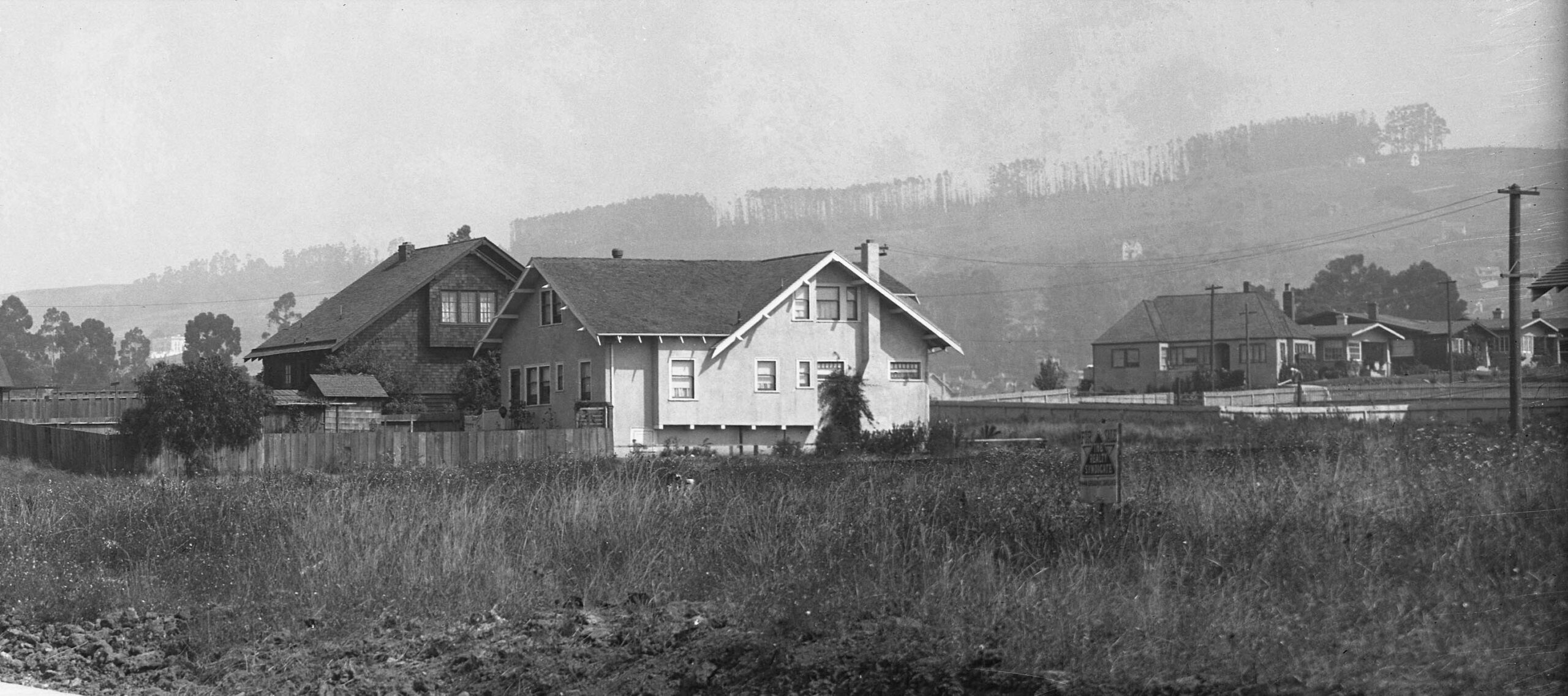
From this point, nothing was found from the 1910s until this northeast image just past the Key Northbrae line crossing just north of Ada St. There is no California St. here as the SP tracks occupy the entire space, and the houses seen here along Hopkins St. are all gone in 2026. The Key tracks can be seen turning onto Hopkins St. across an empty field that will become Berkeley Horticulture in the next decade. The photographer of this image was not provided, or whether this print represents the whole negative or has had the photographer’s designation cropped.
L347-50-SP Historical Collection, Courtesy BAERA, Western Railway Museum Archives, 63831sp, (Image 10 of 30)
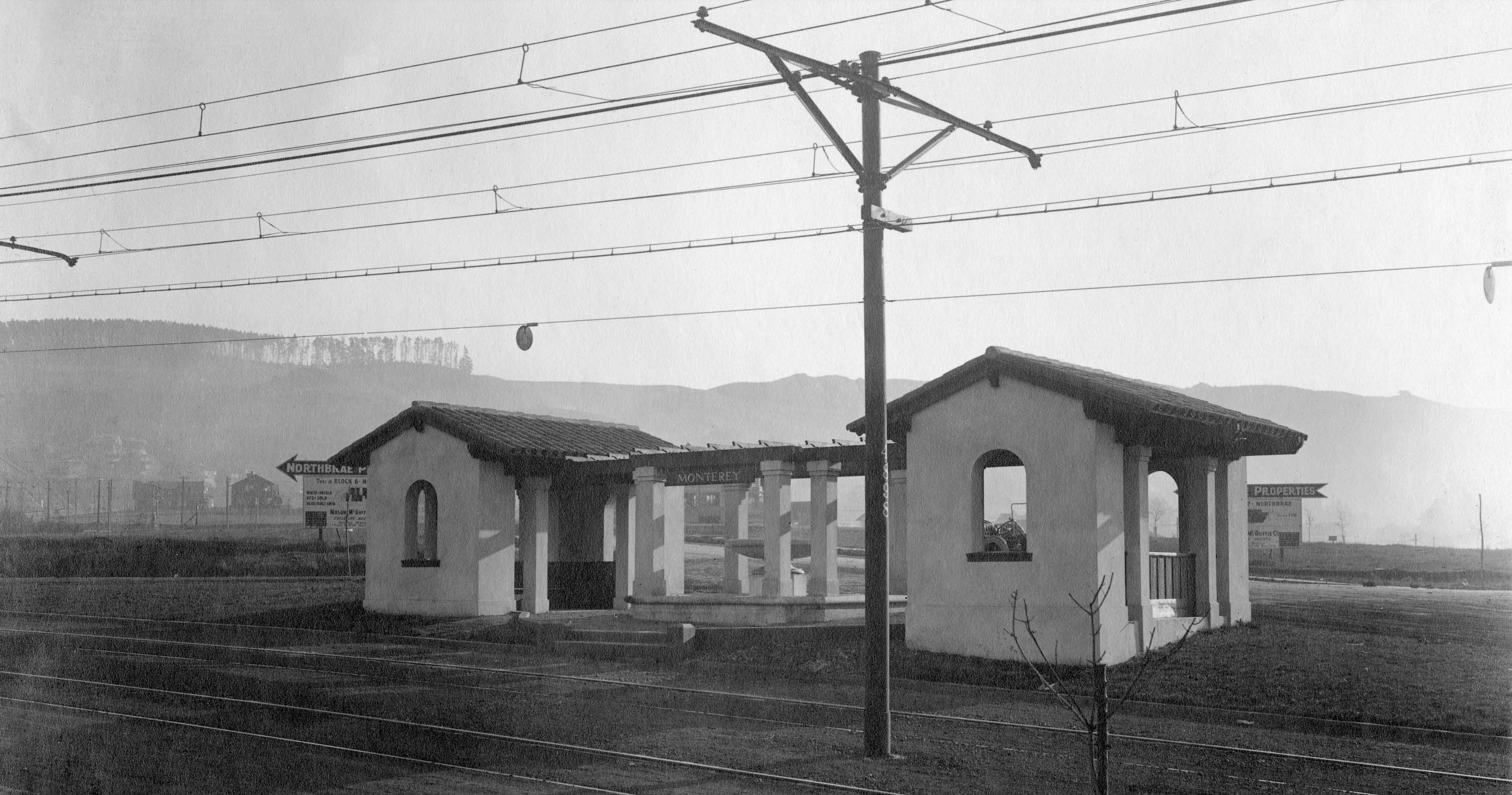
The only image along Monterey Ave. found was this northeast view at the Posen Ave. shelter ca. 1912. The billboards indicate whose real estate realm has been entered.
L347-55-Louis L. Stein Collection, Courtesy BAERA, Western Railway Museum Archives, 267175oa&b, (Image 11 of 30)
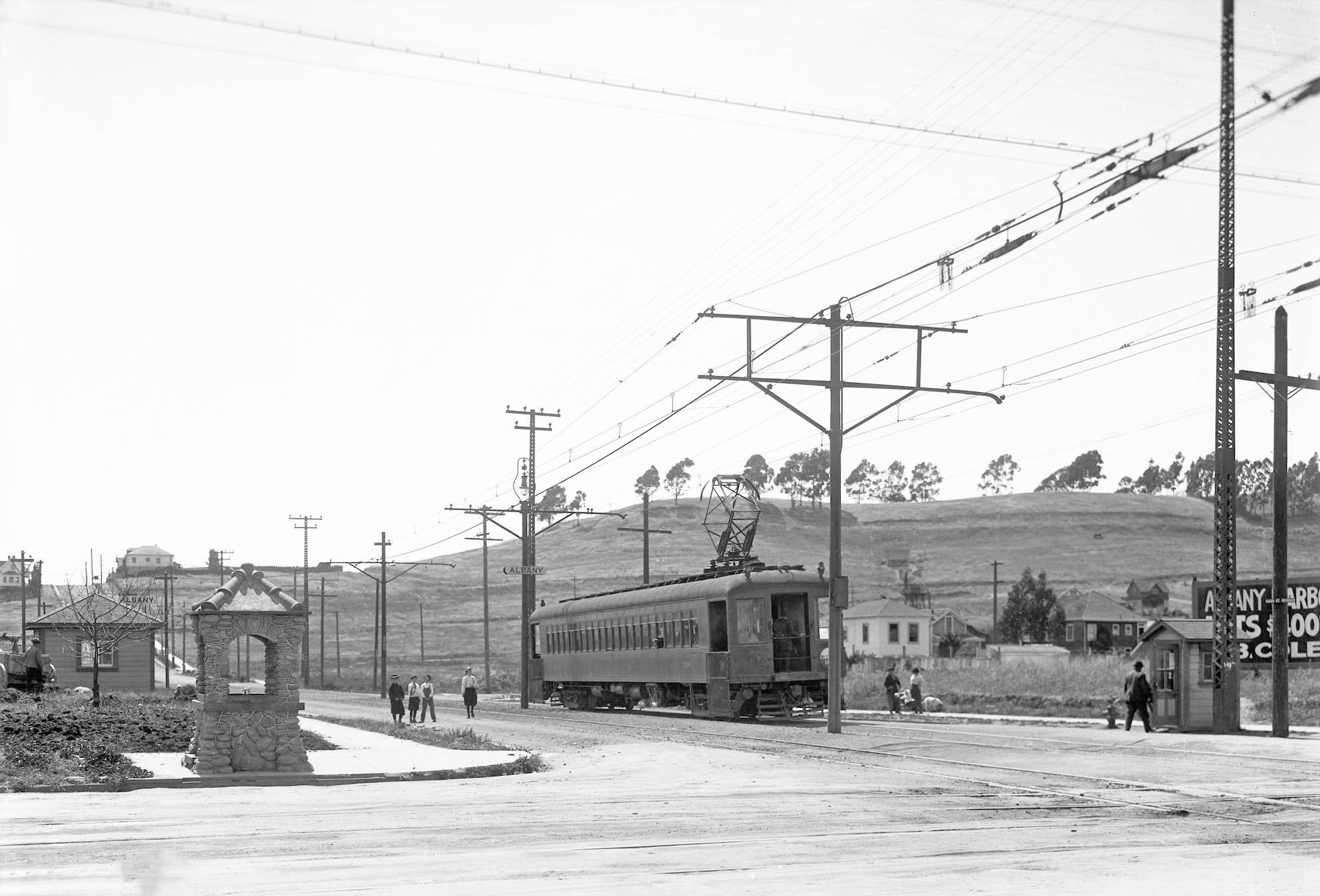
Any image of a Ninth St. train in the 1910s is rare. This west view at Solano Ave. across San Pablo Ave. shows a single car train heading to Thousand Oaks. It features Albany Hill and the Albany station sign on the pole across from the shelter seen at the left edge. Interesting theta the station was called Albany at this spot as the train had already made a stop in Albany at Buchanan St. The photographer of this image was not listed, but it looks like a Cheney that has been cropped.
L347-57-Vernon Sappers Collection, Courtesy BAERA, Western Railway Museum Archives, 41693oa&b, (Image 12 of 30)
This second west view on Solano Ave. in Albany received an “N” designation from Cheney. It displays how wide-open Albany was at the time. The house seen at the southwest corner of Solano and Pomona Aves. is long gone, as it the Santa Fe RR Masonic Tower seen along the right edge.
L347-60-Vernon Sappers Collection, Courtesy BAERA, Western Railway Museum Archives, 22388oa&b, (Image 13 of 30)
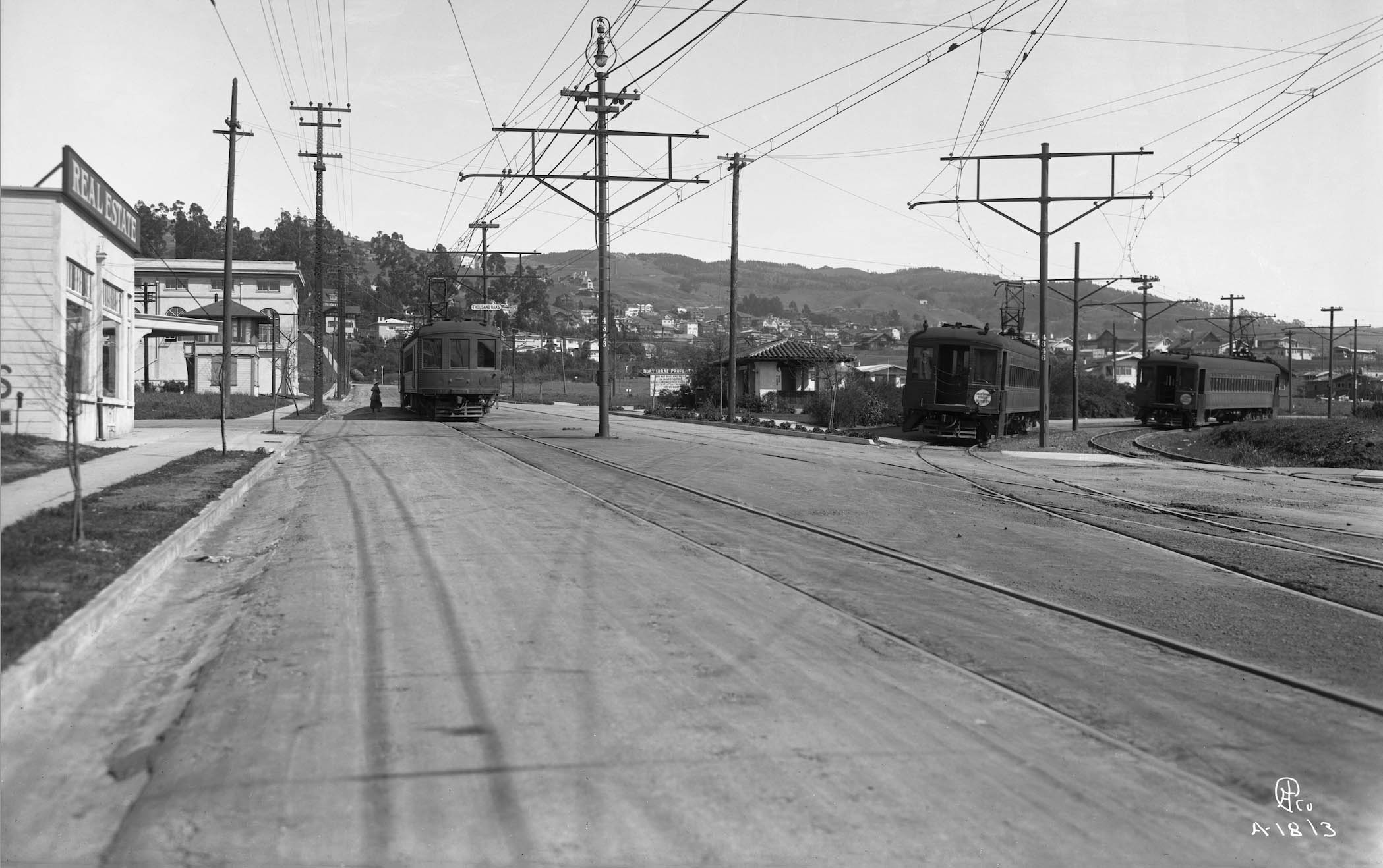
This east view also on Solano Ave. is designated “A-1318”, but as will be apparent soon, there is method to Cheney’s madness. This east view is not from 1912, but several years later as a real estate building is now present across from the Thousand Oaks station. A Shattuck Ave. and two California St. cars wait at the terminus of the loop lines.
L347-65-Eston Cheney Photo A-1318, Sappers Collection, Courtesy BAERA, Western Railway Museum Archives, 24650oa&b, (Image 14 of 30)
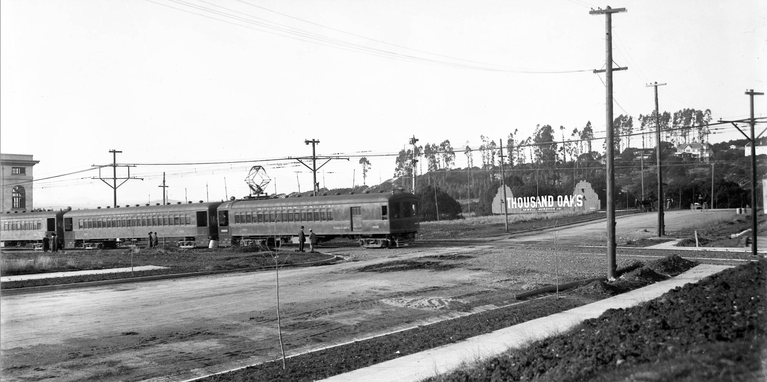
Now at Solano Ave. and Fresno Ave., this northwest view features a Thousand Oaks sign by real estate developer Newell-Murdoch Co. of San Francisco, also responsible for the Forest Hill community in that city. The scratched-out designation on this plate appears to be from Mercantile Advertising Company, and some claims have been made that Cheney may have provided photographs to this firm as well. This images was said to be from 1912, and the presence of the buggies supports that possibility.
L347-70-Mercantile Advertising Company Photo, Sappers Collection, Courtesy BAERA, Western Railway Museum Archives, 22368oa&b, (Image 15 of 30)
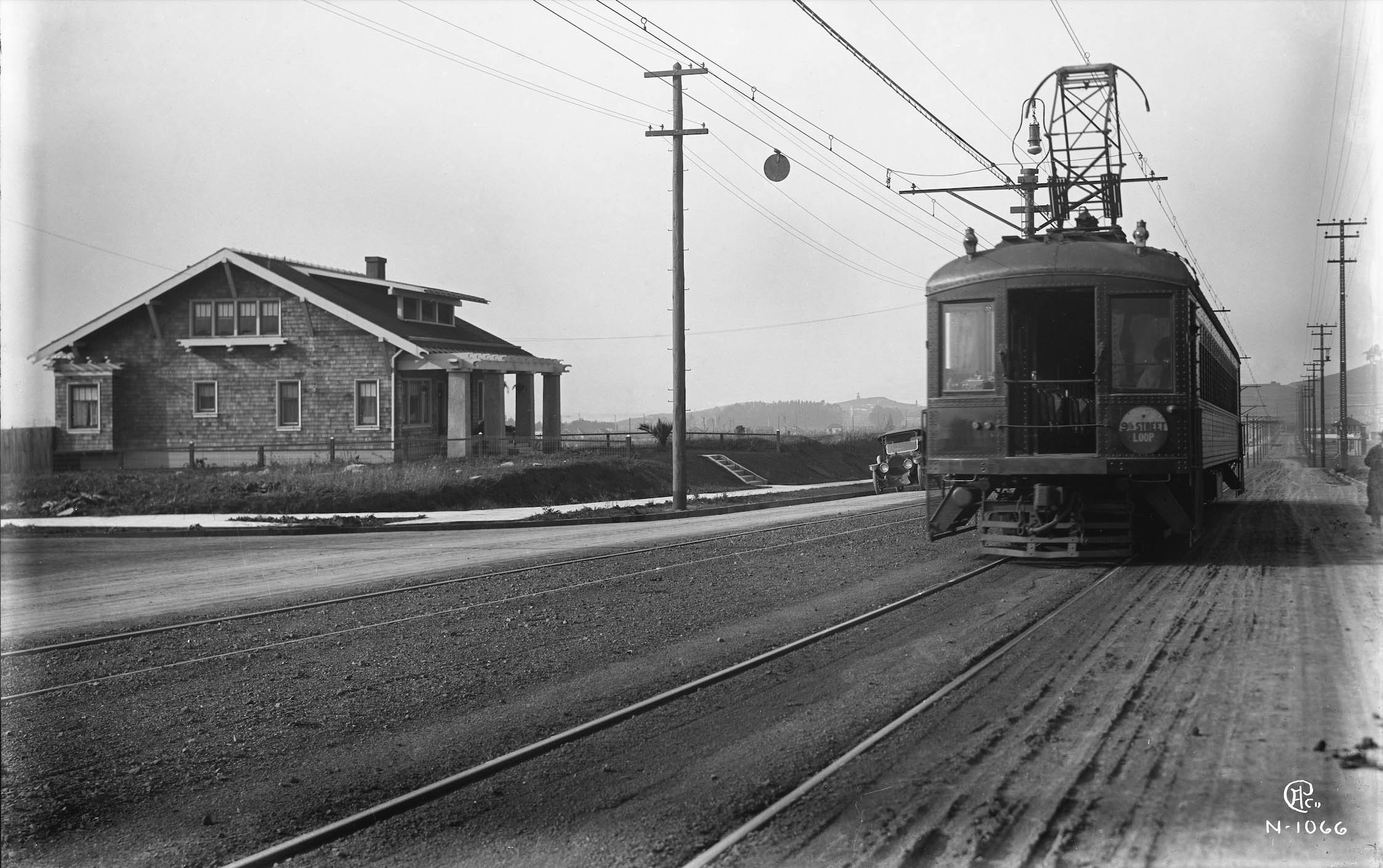
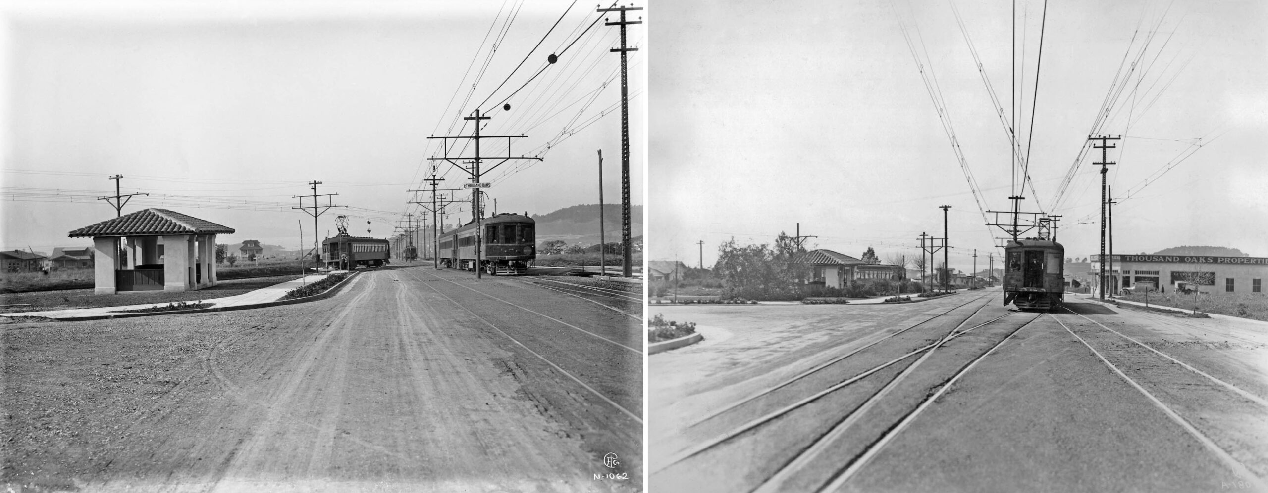
To finish up the SP Thousand Oaks station area and Cheney’s methods, these two west views near the Colusa Ave. shelter are shown side-by-side. The one on the the left uses an “N” before the number designation, and the one on the right uses an “A”. Indeed, going through several Cheney images from this area, ones with an “N” are earlier, ca. 1912, and the ones with an “A” show the George Friend Real Estate building that was the later addition. So the letters are at least consistent with time. Note the image on the left has trains from all three SP lines showing.
L347-75-Eston Cheney Photos A-1807, l, N-1062, r, Sappers Collection, Courtesy BAERA, Western Railway Museum Archives,, (Image 16 of 30)
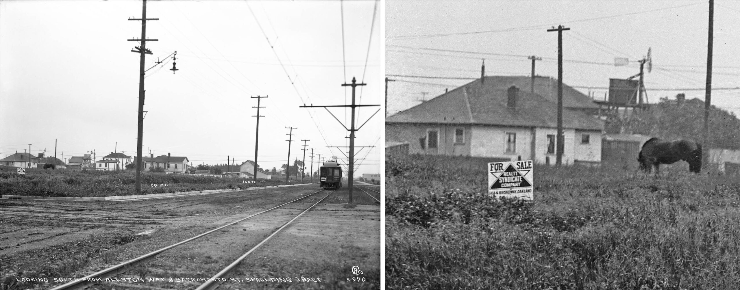
Now turning to the Key Northbrae line heading north on Sacramento St. On the left, a south view down Sacramento St. with car no. 588 heading north. It is designated with an “S”, earlier meaning a photo taken from Sacramento St. viewed to the east. On the right, a sign confirming that the Spaulding Tract was under the auspices of the Realty Syndicate. Earlier images with a “B” also show Syndicate lots, so the “S” does not necessarily stand for Syndicate.
L347-80-Eston Cheney Photo S-970, Sappers Collection, Courtesy BAERA, Western Railway Museum Archives, 17762ks, (Image 17 of 30)
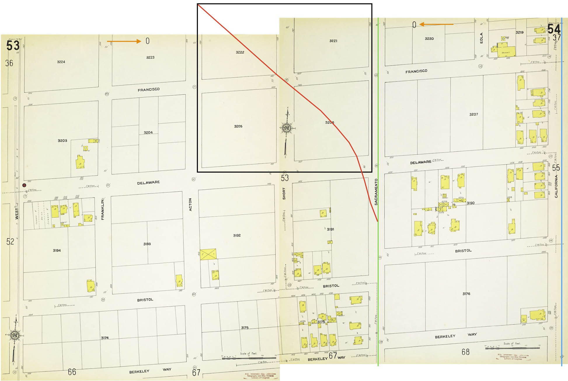
The next set of images from the 1910s go to Delaware St. and north falling out of Sanborn map 1911 coverage as shown on this composite map featuring the Key Northbrae line, green, Key Westbrae line, red, and added for completeness, the SP California St. line in blue. The “0” marked by the orange arrows indicate no further coverage in that direction, in this case to the north. The area marked in black is the future site of the BART North Berkeley station and shows how both Francisco and Short Sts. had once crossed this section uninterrupted.
L347-85-Courtesy Library of Congress, Geography and Map Division, Sanborn Map Company, 1911; Vol. 1, Panels 53 and 54, (Image 18 of 30)
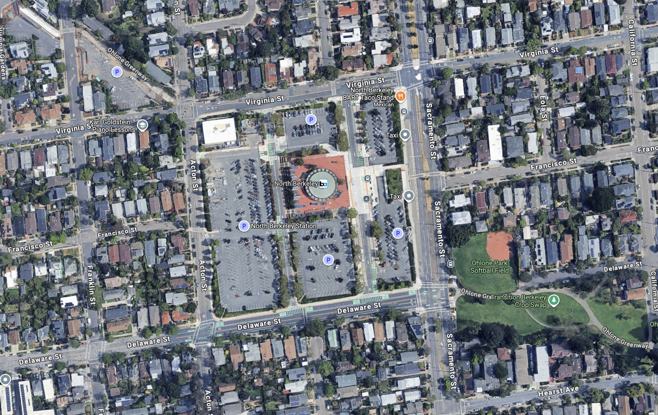
This aerial north-oriented view from 2026 shows the area in question. Note that BART follows the Ohlone Greenway in both directions from the station area, the portion heading to the northwest courtesy the abandoned Key Westbrae line.
L347-90-Courtesy Google Maps, (Image 19 of 30)
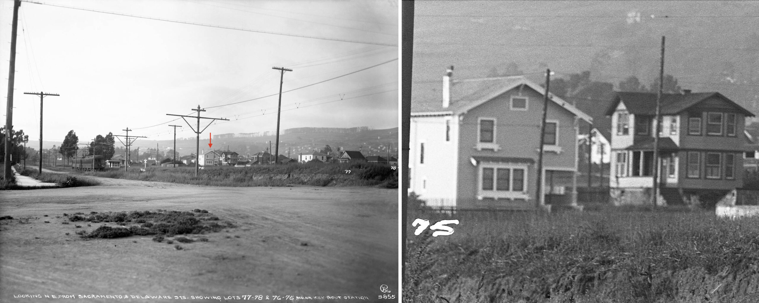
The next ground image by Cheney on Sacramento St. stays with the “S” designation. A two-car Northbrae train is at the Virginia St. shelter that is physically at Francisco St., left panel. This has to be the case as the red arrow points to no. 1517 Virginia St., still there in 2026, and one block north of where the train has stopped. It is shown in detail on the right.
L347-95-Eston Cheney Photo S-855, Vernon Sappers Collection, Courtesy BAERA, Western Railway Museum Archives, 17747oa&b, (Image 20 of 30)
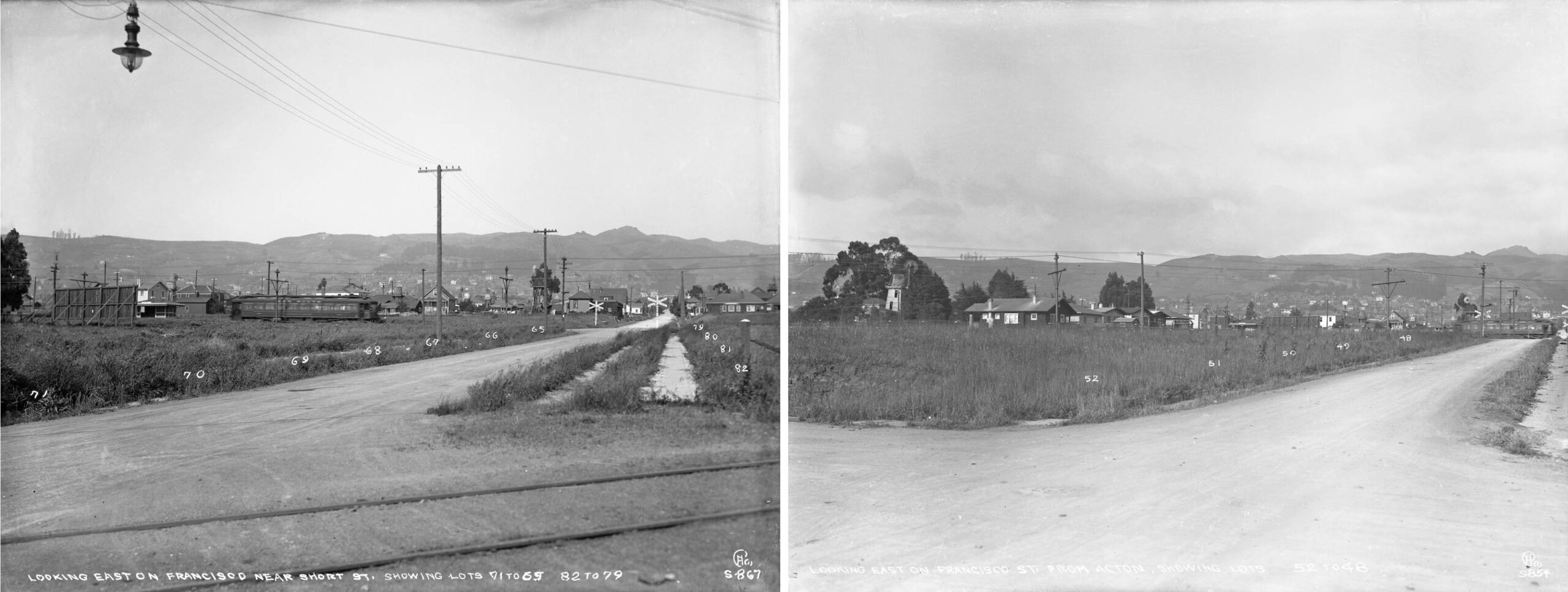
Two more “S”-designated images that were not taken on Sacramento St. and are east views are shown here. On the left, the photographer is standing just west of the Key Westbrae tracks catching a moving Northbrae train. In 2026, this individual would be standing on top of the circular dome at the direct center of the BART station. The right east view was taken one block west on Acton St., shows a Westbrae train in motion. Numerous Realty Syndicate lots are for sale.
L347-100-Eston Cheney Photos S-867, l, S-855, r, Sappers Collection, Courtesy BAERA, Western Railway Museum Archives, 17750ks, (Image 21 of 30)
A detail from the image in the previous left panel contrasts the small houses, water tanks and wind pumps or water-pumping windmills used to pump groundwater up to the elevated tanks versus the large, multistory houses in the hills in the background.
L347-105-Eston Cheney Photo S-867, Sappers Collection, Courtesy BAERA, Western Railway Museum Archives, 17750ks, (Image 22 of 30)
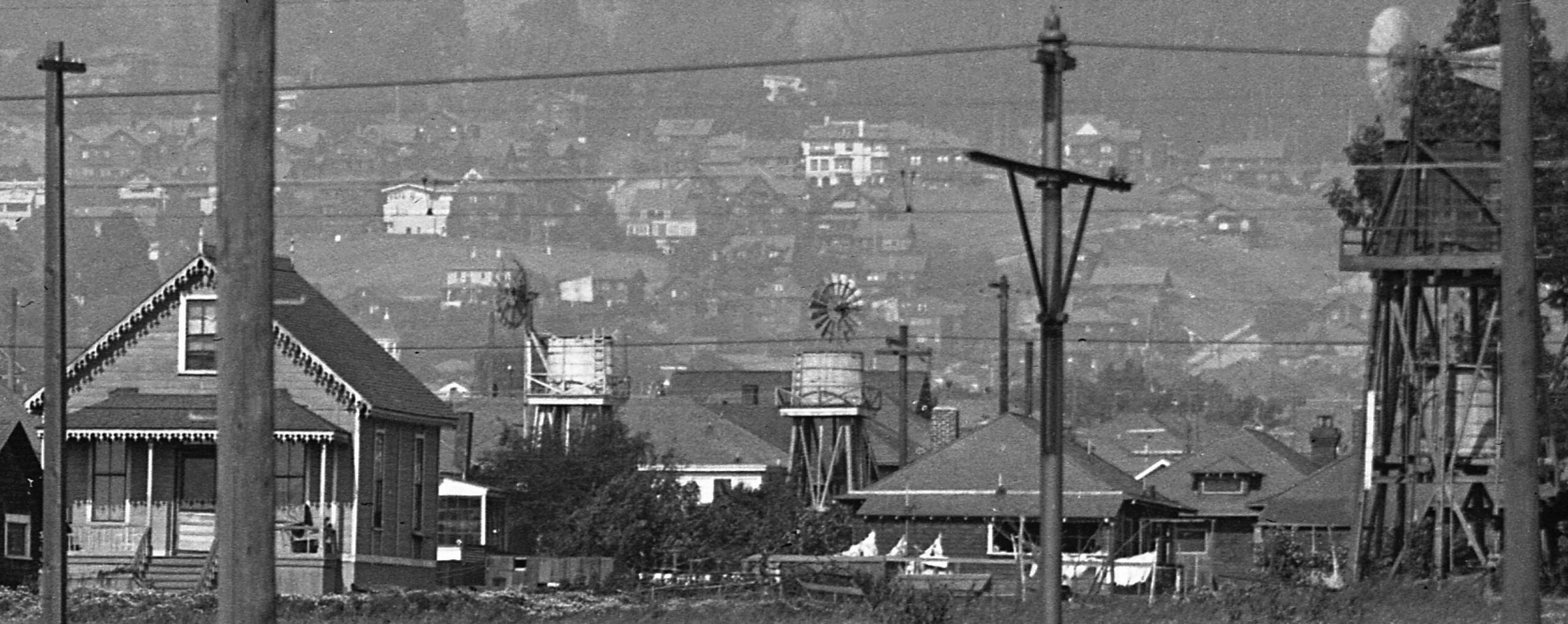
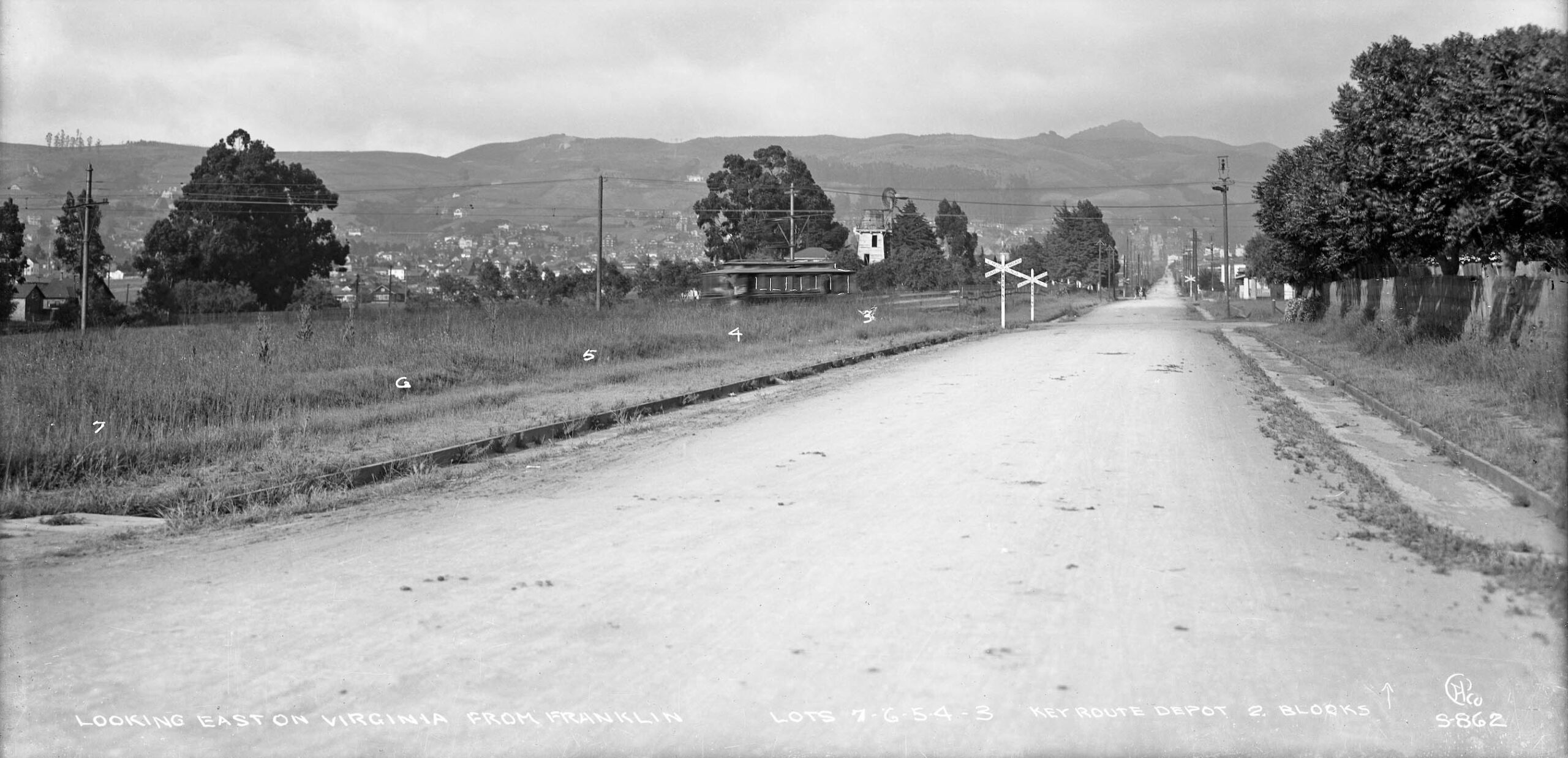
Next an east view from Franklin St. down Virginia St. showing a Westbrae car about to cross the latter street. Another “S” designated glass plate, it also features more lots for sale as well as another large water tower.
L347-110-Eston Cheney Photo S-862, Sappers Collection, Courtesy BAERA, Western Railway Museum Archives, 17748ks, (Image 23 of 30)
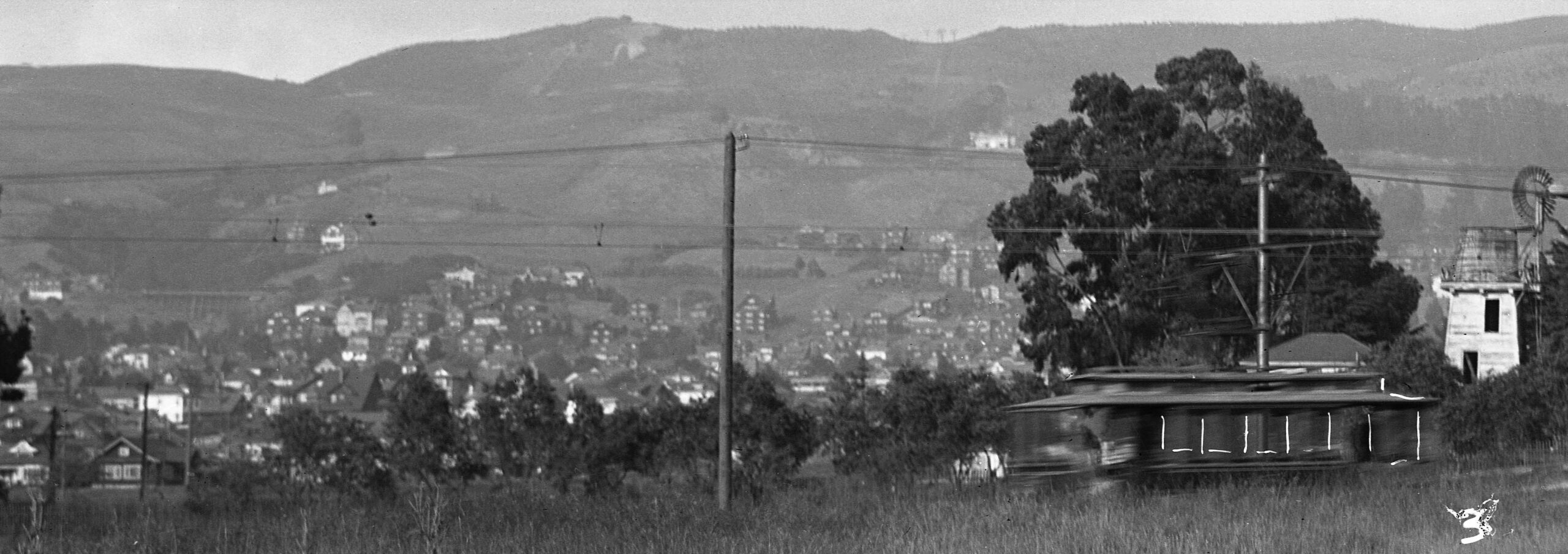
A detail from the image in the previous panel shows that Cheney took some artistic liberties in enhancing the look of the Key car, and toward the left margin, center, a striking view of the Key’s Codornices Trestle along Euclid Ave. in the Berkeley hills.The structure existed between 1912-1927, after which it was filled in according to Vernon Sappers’ “Key System Streetcars”, 2007, Signature Press.
L347-115-Eston Cheney Photo S-862, Sappers Collection, Courtesy BAERA, Western Railway Museum Archives, 17748ks, (Image 24 of 30)
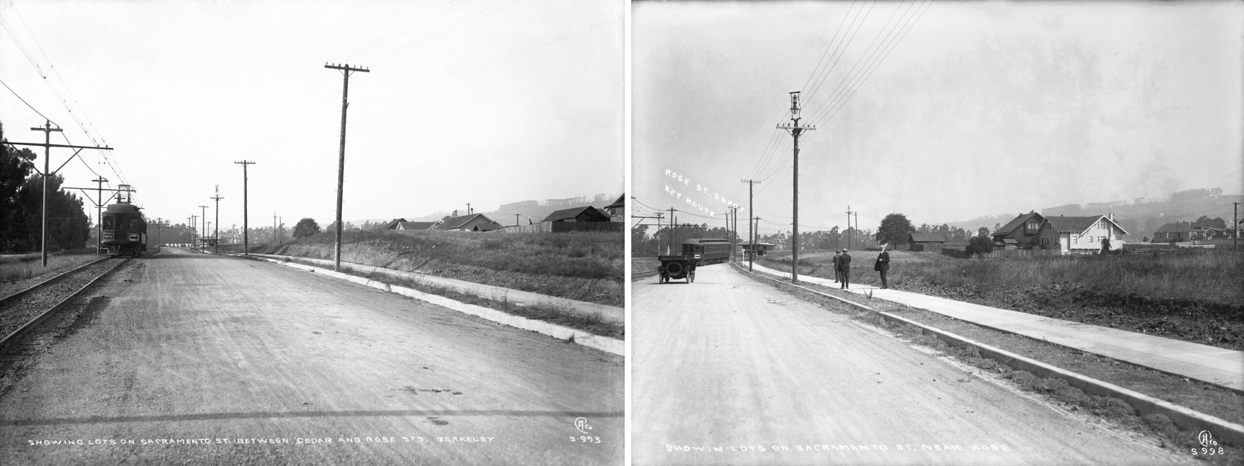
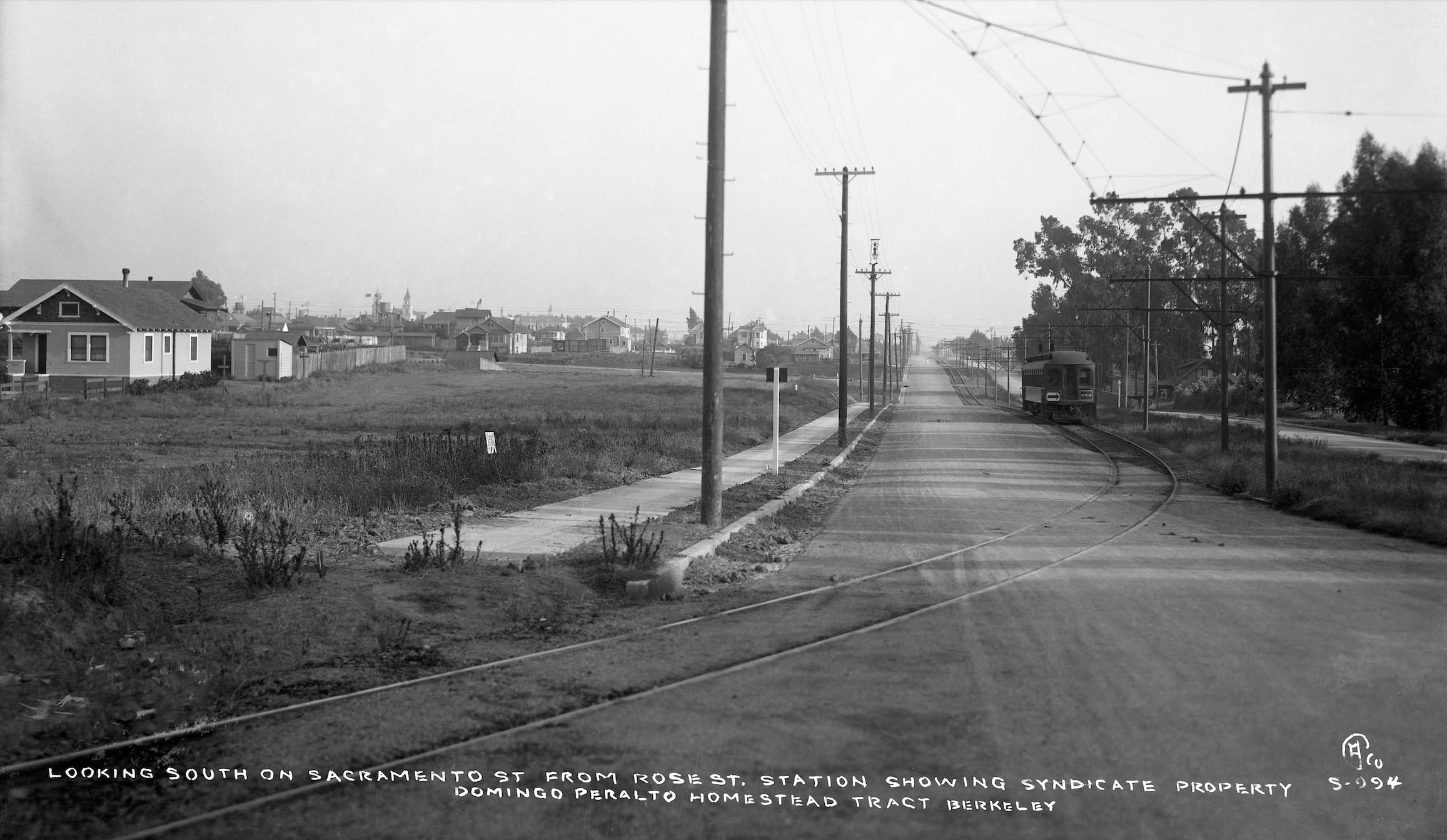
North of Cedar St. on Sacramento St., two more “S” plates showing the single-track line heading for the Rose St. station shelter seen in the distance.
L347-120-Eston Cheney Photos S-993, l, S-998, r, Sappers Collection, Courtesy BAERA, Western Railway Museum Archives, 17765ks, (Image 25 of 30)
A detail from the right panel of the previous entry shows two houses that remain in 2026 on Holly St. The house in the center just north of the Realty Syndicate sign is no. 1418 Holly St. Just north of it is a house that has been featured twice in this series of updates at no. 1410. While the Northbrae line was being built, the latter had a water tank, but it has since disappeared.
L347-125-Eston Cheney Photo S-998, Sappers Collection, Courtesy BAERA, Western Railway Museum Archives, 17767ks, (Image 26 of 30)
Finally a south view at the Rose St. curve with Key car 573 now past the blocks of single-track right-of-way north of the spit with the Westbrae line. Another undated 1910s “S” designated plate. For a few images in the Northbrae portion of the line, see the end of the previous update in this series, click here and view the presentation backwards. This update may not have solved the Cheney photo designation mystery, but it shows some consistencies relative to photos from other areas.
L347-130-Eston Cheney Photo S-994, Sappers Collection, Courtesy BAERA, Western Railway Museum Archives, 17766ks, (Image 27 of 30)
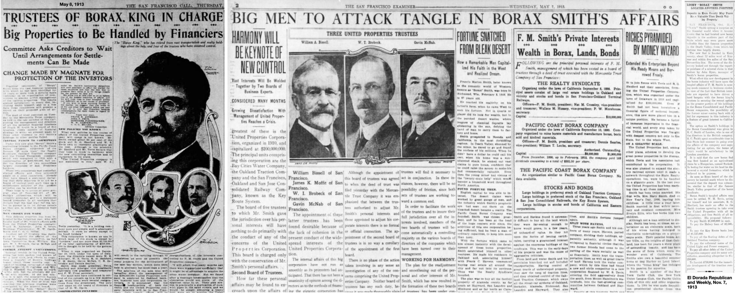
It would be negligent to leave the 1910s without mentioning the troubles faced by the Key and SP. Borax Smith was forced out of his railways on May 6. 1913 by bankers representing the lenders. The newspapers of the day, left and center, spell it out, too much overcapitalization, stock inflation and borrowing, his entire equity gone requiring over 20 years of litigation according to Sappers. He was never involved in railways again, but according to the El Dorado Republican, Nov. 7, 1913, right, he would recover somewhat in the discovery of new borax deposits more valuable than what he had found in Death Valley.
L347-135-Courtesy Newspapers.com, (Image 28 of 30)
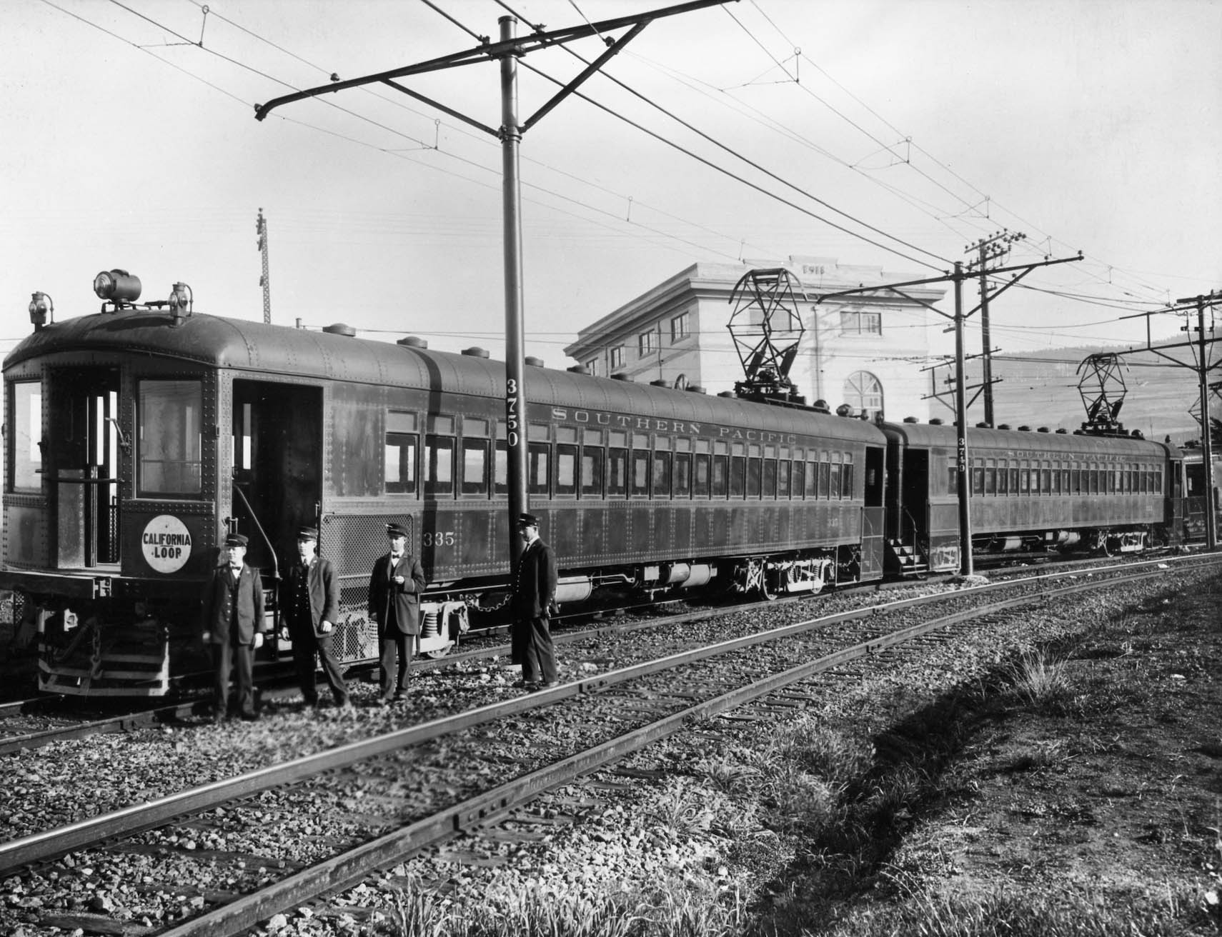
A northeast view at the Thousand Oaks wye with an early test run of a California line train with SP 335 and 313 on Jan. 4. 1912 is shown here. The SP had its own set of issues, losing money from the get go with a deficit of $383,982 versus revenues of $1.3M according to Robert Ford in his book. “Red Trains in the East Bay”, Interurbans, 1977. They angered riders charging more on lines not competing with the Key interurbans, and created conflict with their workers for trying to downgrade their pay. They faced several regulatory challenges to their relationship with the Union Pacific and Central Pacific, none impacting the electrics when resolved.
L347-140-SP Official Photo Harry Aitkin Collection, Courtesy BAERA, Western Railway Museum Archives, 70172ier, (Image 29 of 30)
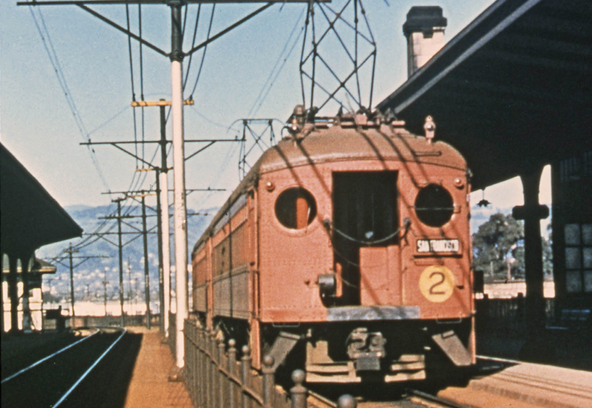
The good news from the 1920s for the SP was that they started painting their electric railway cars red as they did for their other electric lines in Aug. 1912. Soon they would get rid of the big square windows in favor of smaller round portals that did not shatter in the case of a crash, the date not found, but images to be shown next time estimate by 1920. The image seen here is a frame from a 1940 taken from a color film made by Charles Savage at 16th St. Station in Oakland. Finally to earn the title of the “Big Red Trains.” Next time, the Roaring 1920s.
L347-145-Charles Savage Photo, Courtesy Catenary Video Productions, (Image 30 of 30)