The Composite Equivalent, The SP Shattuck Line Wins Out, 1933
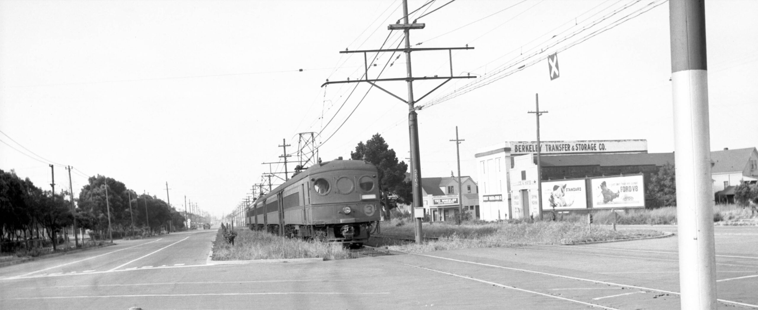
By the time this south view was taken in May 1940, the Southern Pacific, SP, Oakland, Alameda and Berkeley suburban lines had been spun off from the parent company as the Interurban Electric Railway, IER, and were using the Bay Bridge to connect the East Bay and San Francisco. The no. 3 line was assigned to the Shattuck local, here combine 625 leads cars 417, 400, 353, and 603. Berkeley Transfer and Storage Co. was at no. 2750 Adeline St, on the west side at the corner with Stuart St. To the east side of the train, the Key System, Key, interurban tracks are absent.
L352-05-Roy Covert Photo, Courtesy BAERA, Western Railway Museum Archives, 70134ier, (Image 1 of 25)

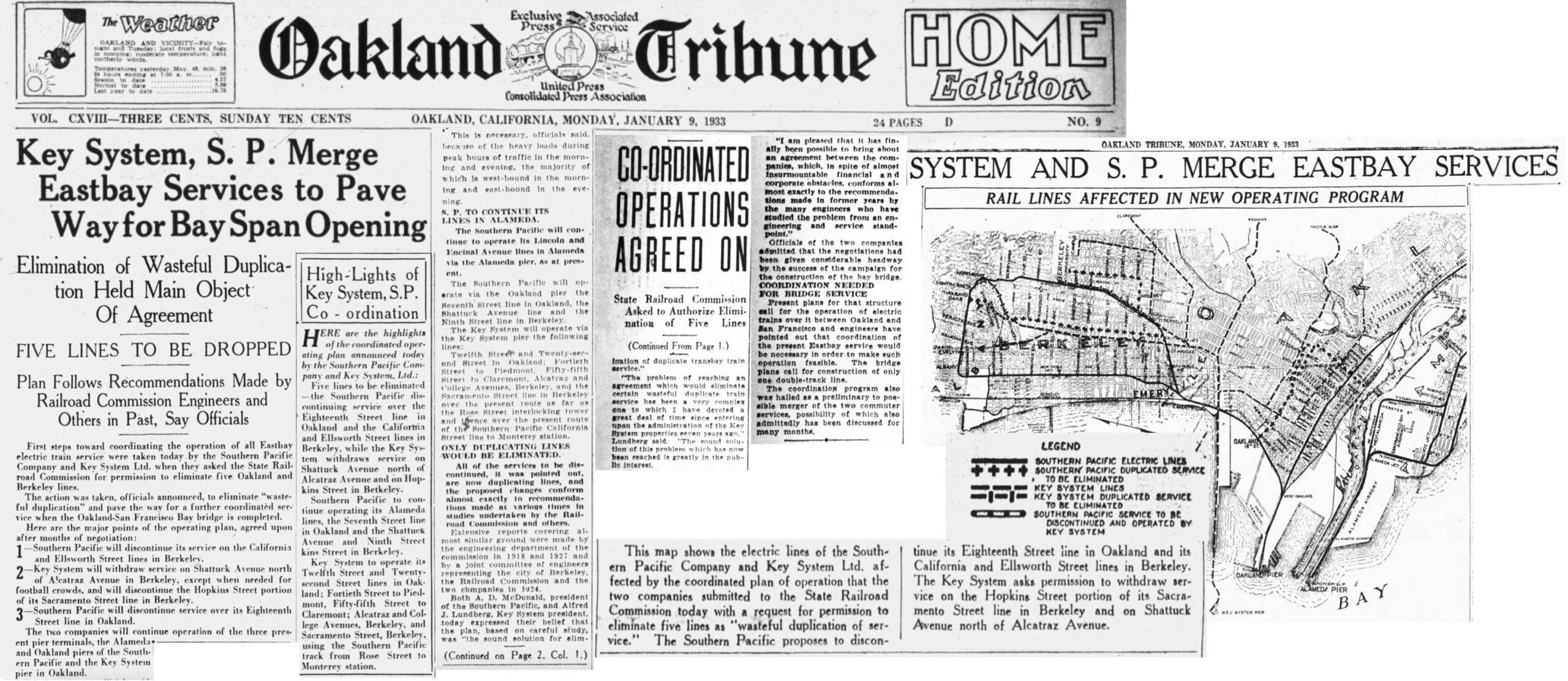
This update continues from the last update where the Key Sacramento St. and SP California St. lines were combined as part of a California State Railroad Commission, RRC, edict approved on Mar. 16, 1933 that would require the SP and Key, to form a functional “Composite Equivalent” or CE that would eliminate or combine lines to reduce competition and eliminate the need to raise transit fares. This update will explain the changes made to service on Adeline St. and Shattuck St. into Berkeley. To view the full RCC document, click here.
L352-10-Courtesy California Digital Newspaper Collection, (Image 2 of 25)
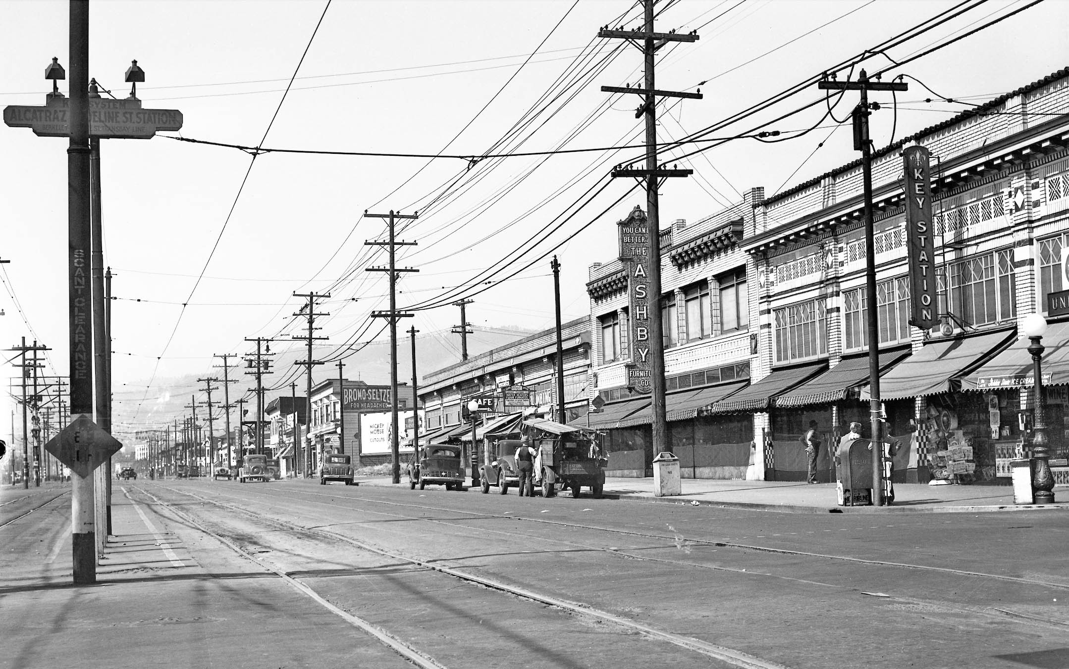
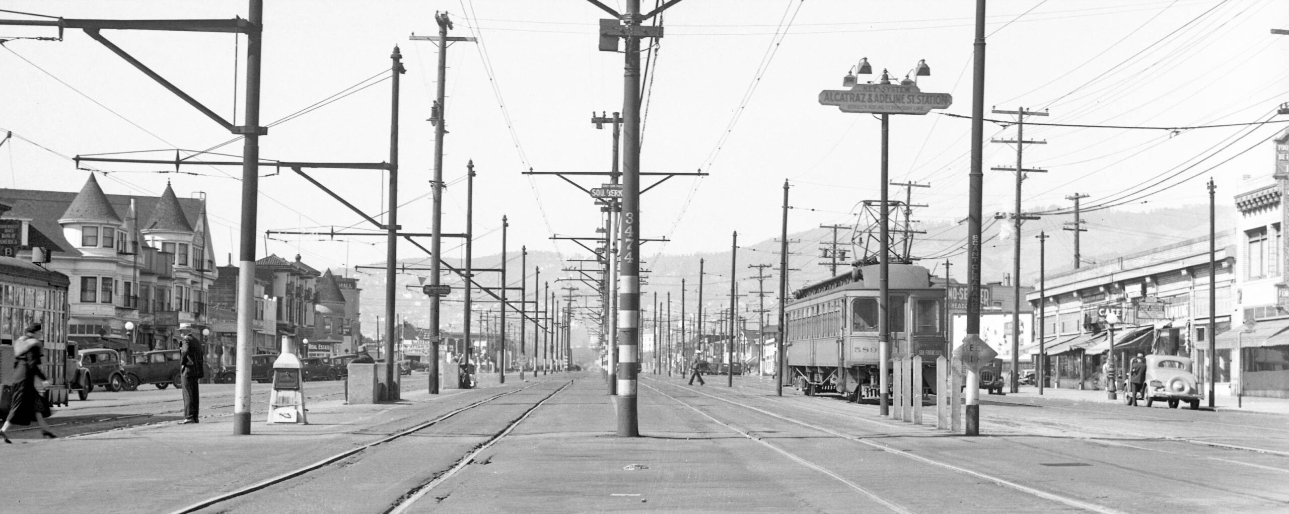
As part of the CE, the Key Shattuck line was cut back from University Ave. to here at Adeline St. and Alcatraz Ave., this northwest view from 1934. All of these tiled facades are gone. The article shown in the previous panel mentions that Key trains would not be allowed to go past this point “except when needed for football crowds” at UC Berkeley. The first image in this update shows that this was not to be, as the track was eventually removed from just north of this point to Ward St. The City of Berkeley was keen to remove those extra two tracks.
L352-15-Key Official Photo, Sappers Collection, Courtesy BAERA, Western Railway Museum Archives, 171280ks, (Image 3 of 25)
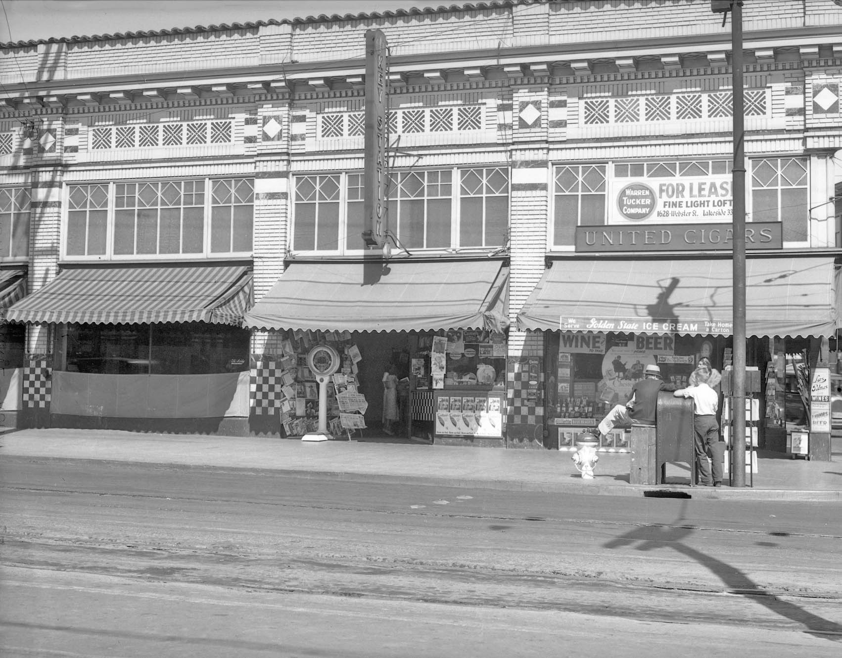
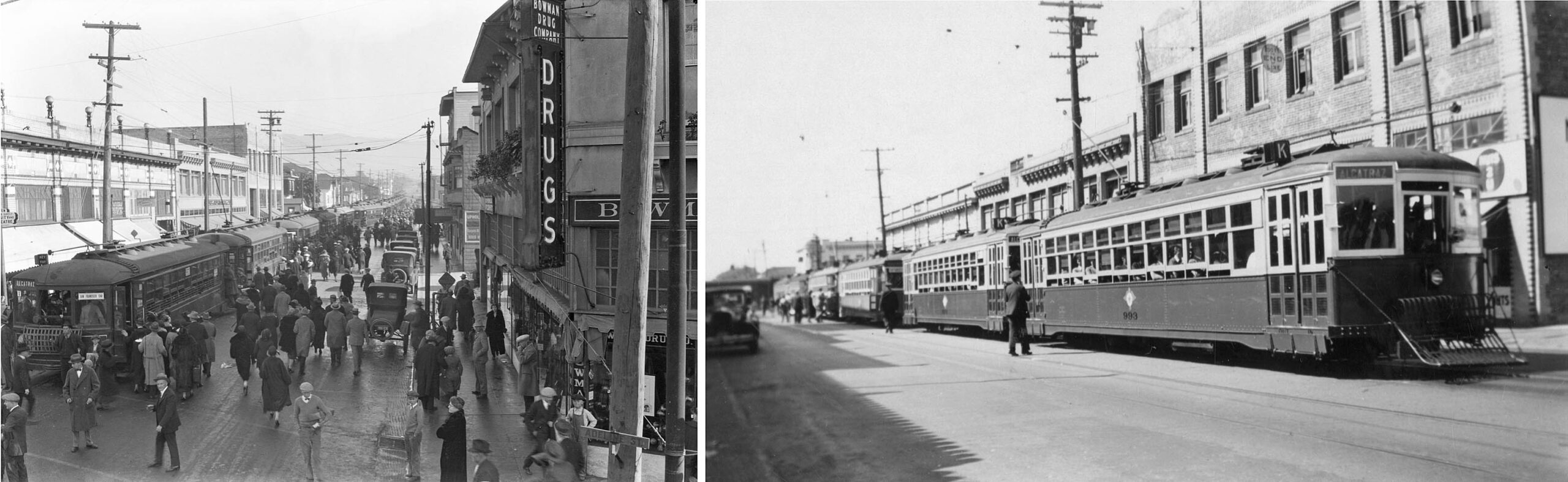
Also from 1934, a close-up of the Key Station on Adeline St. at Alcatraz Ave., east view. The truncation of the interurban Shattuck line was buffered by the presence of the no. 31 line or soon to be renamed K line. According to Vernon Sappers “Key System Streetcars”, Signature Press, 2007, the 2.54 mile line traveled down College Ave. to connect Telegraph Ave. and Bancroft Way to Adeline St. and Alcatraz Ave. Trains lined up at the latter terminus would shuttle passengers from the terminating interurbans to the UC campus for football games.
L352-20-Key Official Photo, Sappers Collection, Courtesy BAERA, Western Railway Museum Archives, 171281ks, (Image 4 of 25)
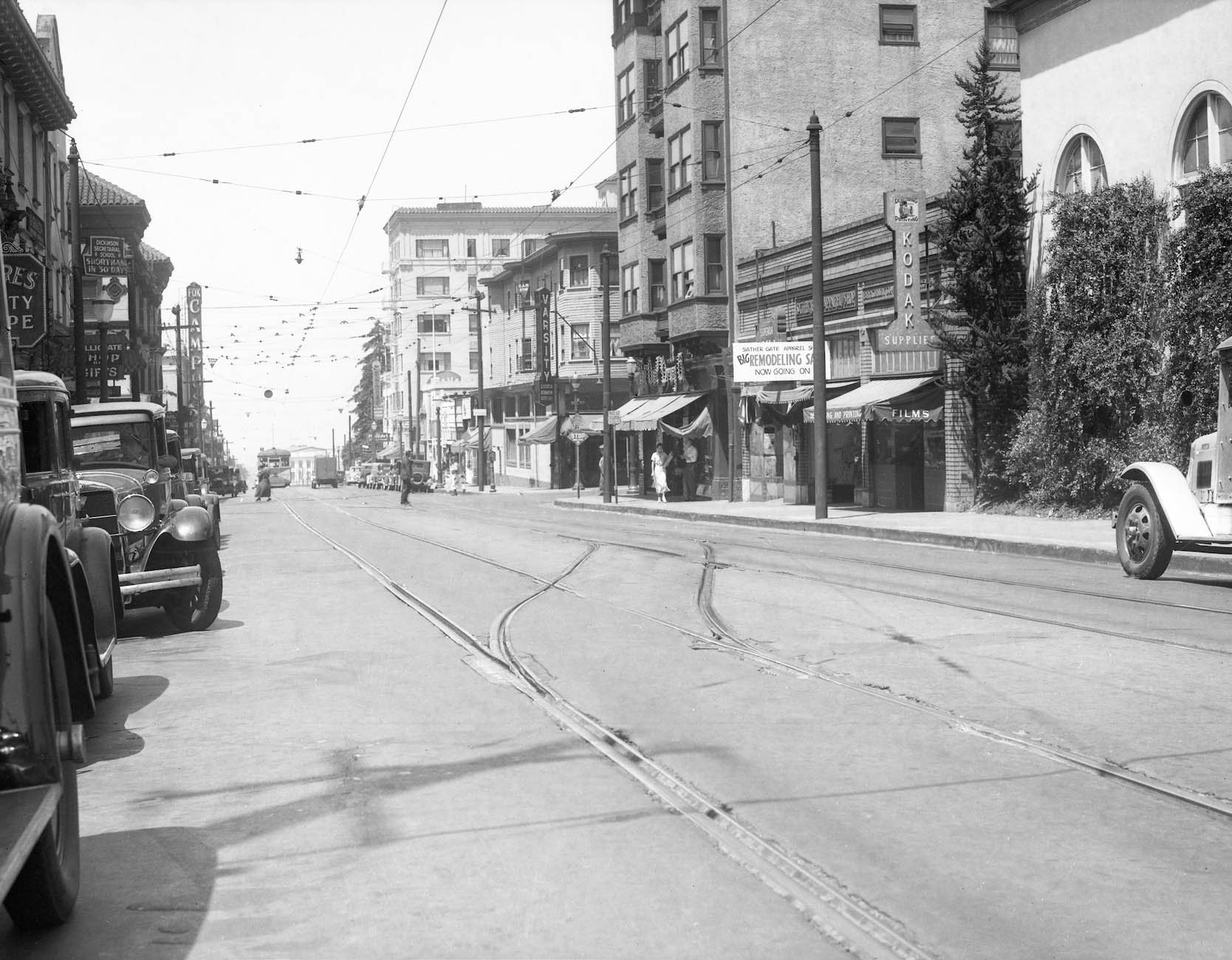
This west view from 1934 down Bancroft Way just east of Telegraph Ave. shows the crossover track where K cars terminated. In the distance is an oncoming no. 5 line streetcar that will turn onto Telegraph Ave. None of the buildings in this scene remain, UC clearing the north side for their campus. The Campus Theater seen here was at no. 2440 Bancroft Way. and opened on Jan. 26, 1926. The Key did experiment between Mar. 6, 1933 and Feb. 1, 1934 with this line terminating at Shattuck Ave., Sappers noting “this proved unsatisfactory” without further elaboration.
L352-25-Key Official Photo, Sappers Collection, Courtesy BAERA, Western Railway Museum Archives, 171282ks, (Image 5 of 25)
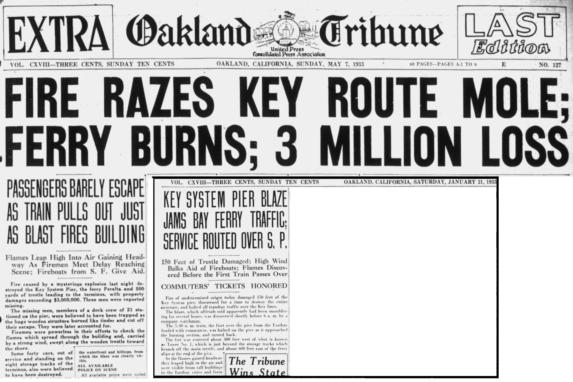
The Key suffered two fires as reported in these two issues of the Oakland Tribune in early 1933, the pier fire of May 6th by far the most devastating. Although the ferry pier was rebuilt, from a purely operational standpoint, the interurban service for the truncated Key “Shattuck” line under the new CE was delayed until 1934.
L352-30-Courtesy California Digital Newspaper Collection, (Image 6 of 25)
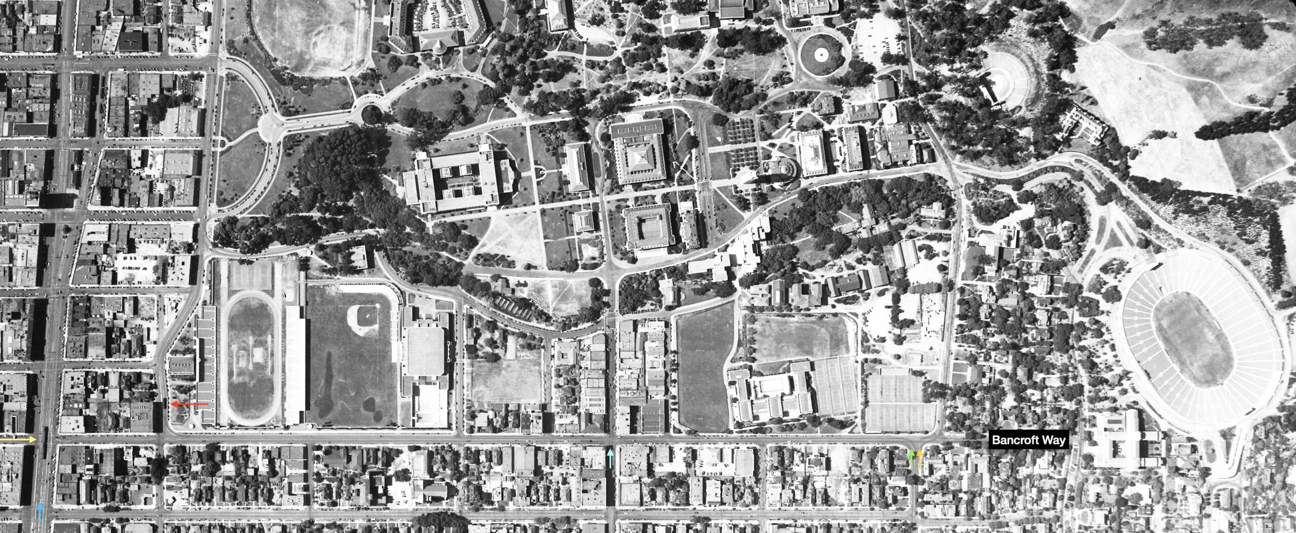
Looking over this aerial from 1938, the SP had the advantage of directly crossing the Berkeley City center, the yellow arrow marking an SP train stopped at Bancroft Way. The Key, however, owned the campus with three streetcar lines and the K line: the no. 4 Shattuck Ave., blue arrow, following the SP route as far north as University Ave.; the no. 5 Telegraph Ave., turquoise arrow, the no. 6 College Ave. streetcar line, orange arrow, and K line, green arrow, all turned left or west on Bancroft Way, the two streetcar lines eventually turning right on Oxford St. (red arrow pointing to a streetcar on Oxford St.,) one block east of Shattuck Ave.
L352-35-Harrison Ryker Photo, Copyright California Department of Transportation, (Image 7 of 25)
As well for Cal football games, whether you consider before, 1924 on left, or after, Oct. 7, 1939 on right, the CE, patrons used for the most part used the Key no. 31 or K line to be left off closer to Memorial Stadium. The view on the left is an east view down Alcatraz Ave. and Adeline St., while the image on the right is a west view toward that intersection.
L352-37-W. E Gardiner Photo, l, Courtesy BAERA, Western Railway Museum Archives, 45240ks, l, 178391, r, (Image 8 of 25)
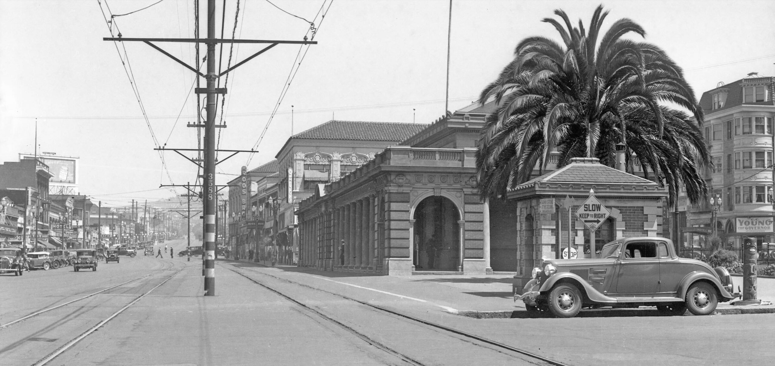
With the SP now in complete control of the Adeline St.-Shattuck Ave. corridor as a result of the CE, the rest of this update will examine images taken in 1934 by the SP to document their line in Berkeley up to and including Thousand Oaks. This first image is a northeast view at Adeline St. and Alcatraz Ave., very similar to the Key shot in L352-15, except here it includes Key 589 at its new terminus, and to the left or west of the two SP tracks, a no. 3 Grove St. Key streetcar. The buildings on the right or east are gone, but those seen north of Harmon St. on the west remain in part.
L352-40-SP Official Photo, Sappers Collection, Courtesy BAERA, Western Railway Museum Archives,170907oa&b, (Image 9 of 25)
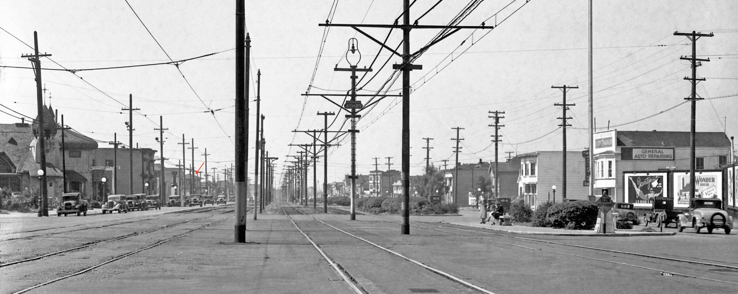
This south view from 1934 between Emerson and Essex Sts. shows the SP Ashby Ave. stop. The entire block on the west or right of the SP tracks was cleared for construction of the BART Ashby station ca. 1968. On the left, the storybook-style building at no. 3049–3051 was built in 1923 for the Hull Undertaking Company’s funeral home, designed by the firm Hutchison & Mills. Included within was the Little Chapel of the Flowers from 1928, designed by Francis Harvey Slocombe. It is known more recently as the home of Marmot Mountain Works from 1976-2021. To read Daniella Thompson’s detailed history, click here. The soon to be razed SP Woolsey St. tower that had monitored SP Ellsworth St. trains crossing the Key tracks is marked by the red arrow.
L352-45-SP Official Photo, Sappers Collection, Courtesy BAERA, Western Railway Museum Archives, 170908oa&b, (Image 10 of 25)
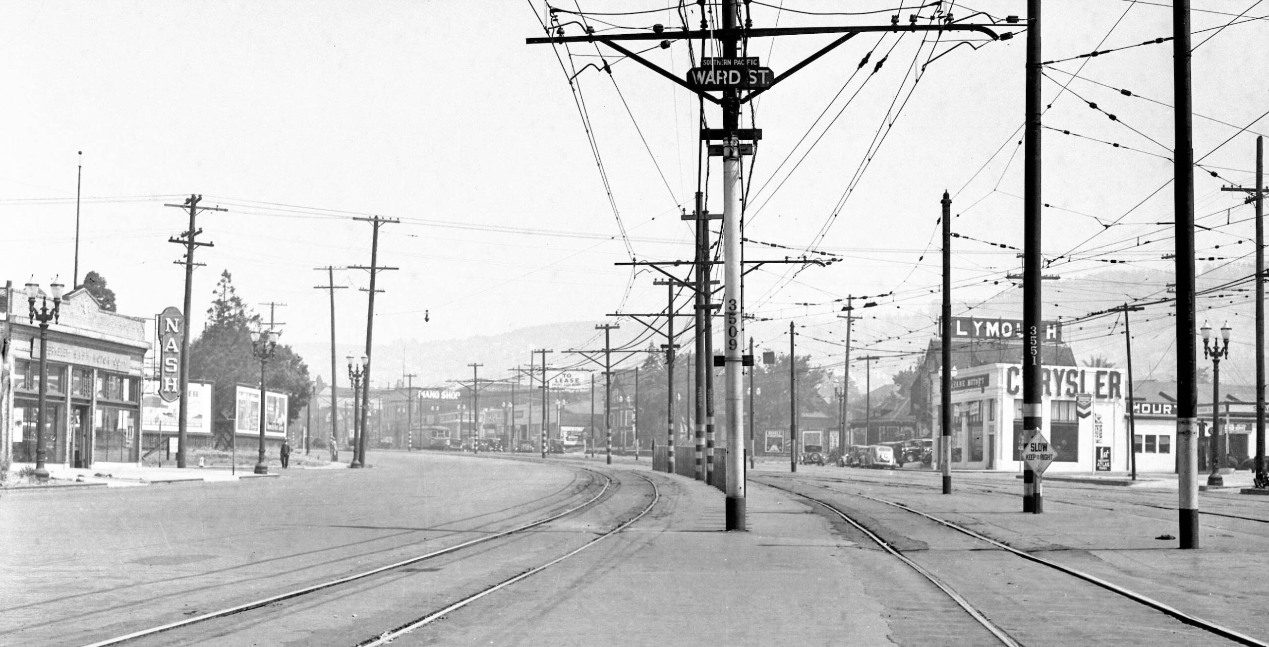
The building marked as Chrysler is all that is left in 2026 from this north view at the SP Ward St. stop in 1934. No. 2655 Shattuck on the corner with Derby St. was originally constructed in 1923, designed by Walter Ratcliff, Jr. for Cochran McCarron, and built by Walter Murch. A showroom used for automobile sales and services upfront, an addition was made to the rear service area in 1927. This structure will be history soon, as an 8-story apartment has been approved for this spot. To read the details, click here. Note the no. 4 Shattuck streetcar in the distance.
L352-50-SP Official Photo, Sappers Collection, Courtesy BAERA, Western Railway Museum Archives, 170909oa&b, (Image 11 of 25)
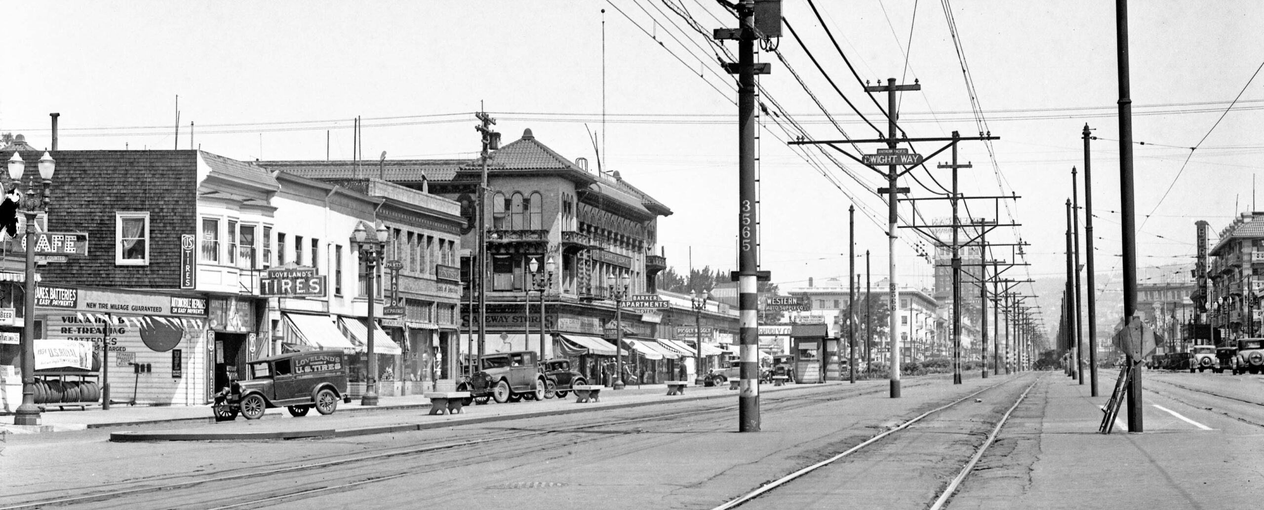
Northward to the SP Dwight Way stop in 1934, the buildings on the left or west remain in 2026, at least as far as SP Pole 3565. The building on the right edge, no. 2429, was the Morrill Apartments, George F. King, architect, and is the Chan Building in 2026. The marquee next to it is of the (New) Berkeley Theater, designed by architect S. Charles Lee of Los Angeles, opening in 1936 and long gone from this spot. Of the many proposals offered by Berkeley to simplify the number of tracks on Shattuck Ave., the only change that was incorporated was to reduce the three tracks the Key used between its interurban and streetcars between Ward St. and Dwight Way down to two.
L352-55-SP Official Photo, Sappers Collection, Courtesy BAERA, Western Railway Museum Archives, 170910oa&b, (Image 12 of 25)
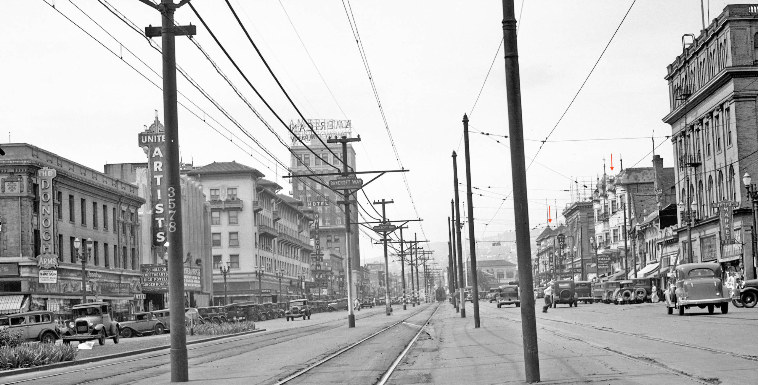
On the subject of theaters, the United Artist at no. 2274 Shattuck Ave. on the left edge of this north view from 1934 at the SP Bancroft Way stop is very topical in 2026 as most of the theater will be demolished for a 17-story high rise. The Art Deco facade will be restored, and integrated into the building. The theater opened in 1932 and was closed in 2023, designed by the architectural firm Walker & Eisen along with architect Clifford A. Balch. As for the other buildings in this image, everything else remains in 2026 except for the two buildings marked by the red arrows. Note the SP train heading north in the distance.
L352-60-SP Official Photo, Sappers Collection, Courtesy BAERA, Western Railway Museum Archives, 170911oa&b, (Image 13 of 25)
Finally arriving at the SP Berkeley Station, a north view at Shattuck Ave. and Center St. in 1934. According to Robert Ford in his book “Red Trains in the East Bay”, Interurbans Press, 1977, the SP received permission from the RRC on Mar. 29, 1938 to close its Berkeley Station and dispose of the property valued at $100k. They would later open a small ticket office at no. 137 Shattuck Sq., in a building constructed on the former station site. The architecture at Shattuck Sq. seen beyond Addison St. has been preserved in 2026, as has the Studio Building on the right edge of the image. In the distance at University Ave. the center poles had been removed, to be explained next.
L352-65-SP Official Photo, Sappers Collection, Courtesy BAERA, Western Railway Museum Archives, 170913oa&b, (Image 14 of 25)
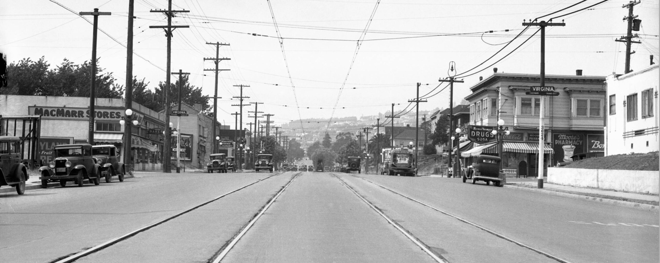
The next stop heading north was Virginia St. seen in this north view from 1934. On the topic of center poles, Ford notes that they were removed in 1927 between University Ave. and Rose St., but also that the tracks were moved closer together as part of a street rebuilding campaign that included previously discussed on Solano Ave. If the tracks were moved, then the entire street must have been repaved, but this has not been substantiated. Nothing remains of the buildings in this image, although the stores starting with the MacMarr store may have been significantly modified. At one point a Safeway occupied the building.
L352-70-SP Official Photo, Sappers Collection, Courtesy BAERA, Western Railway Museum Archives, 170915oa&b, (Image 15 of 25)
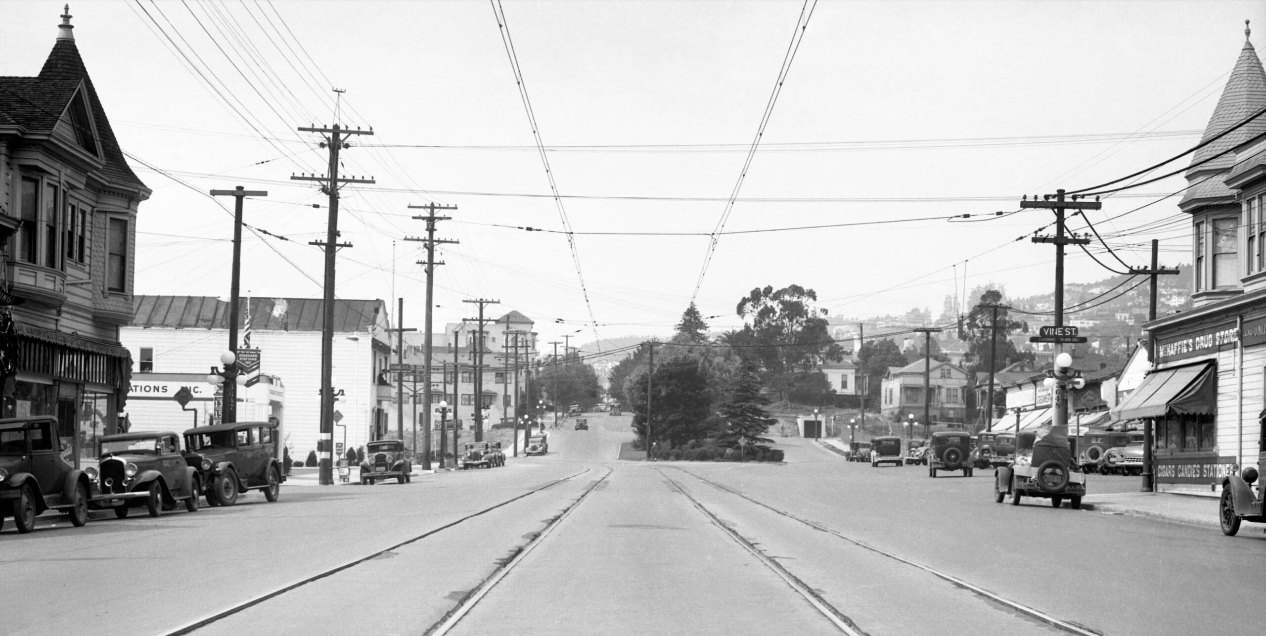
The next stop as seen in this north view from 1934 was Vine St. Both buildings on the south side of Vine St. remain in 2026. The turn onto Henry St. can be appreciated in the distance.
L352-75-SP Official Photo, Sappers Collection, Courtesy BAERA, Western Railway Museum Archives, 170916oa&b, (Image 16 of 25)
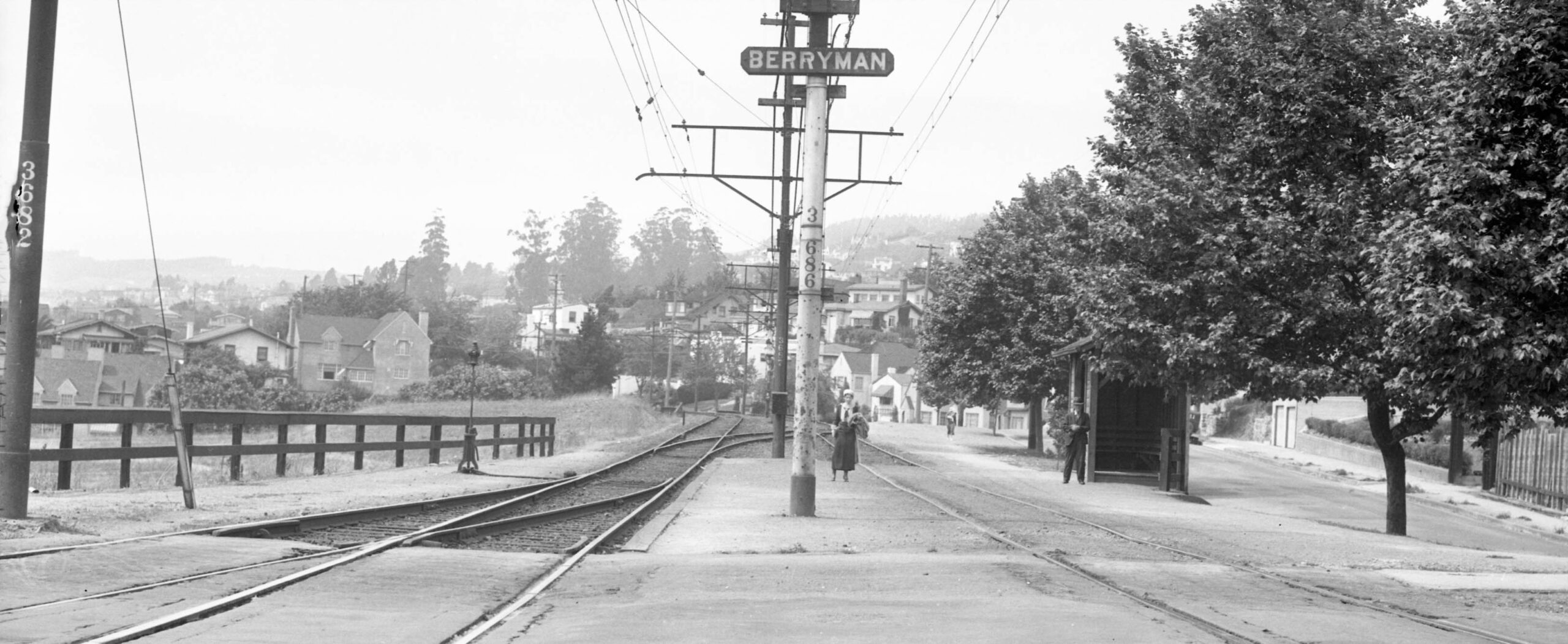
At Berryman on its private right-of-way in this north view from 1934, the center poles are back. The small shelter may be appreciated, as well as the switch tracks that provided access to the SP yard just south and west of this station stop. Note in the distance the steel overpass for Eunice St. leading to a curve to the west.
L352-80-SP Official Photo, Sappers Collection, Courtesy BAERA, Western Railway Museum Archives, 170917oa&b, (Image 17 of 25)
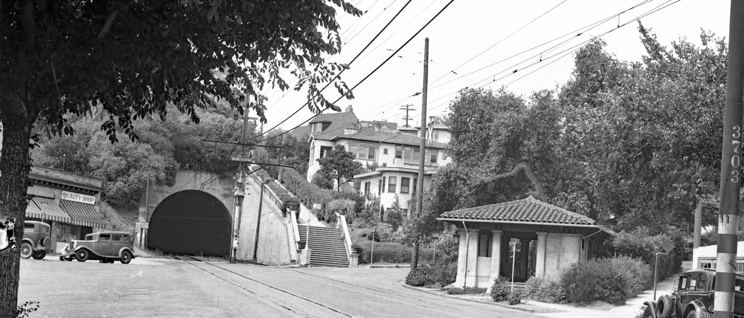
Back on asphalt and further north the tunnel appears at the Northbrae stop as seen in this northeast view from 1934. The Fountain Walk, left, and Terrace Walk, right, can be appreciated on either side of the shelter.
L352-85-SP Official Photo, Sappers Collection, Courtesy BAERA, Western Railway Museum Archives, 170918oa&b, (Image 18 of 25)
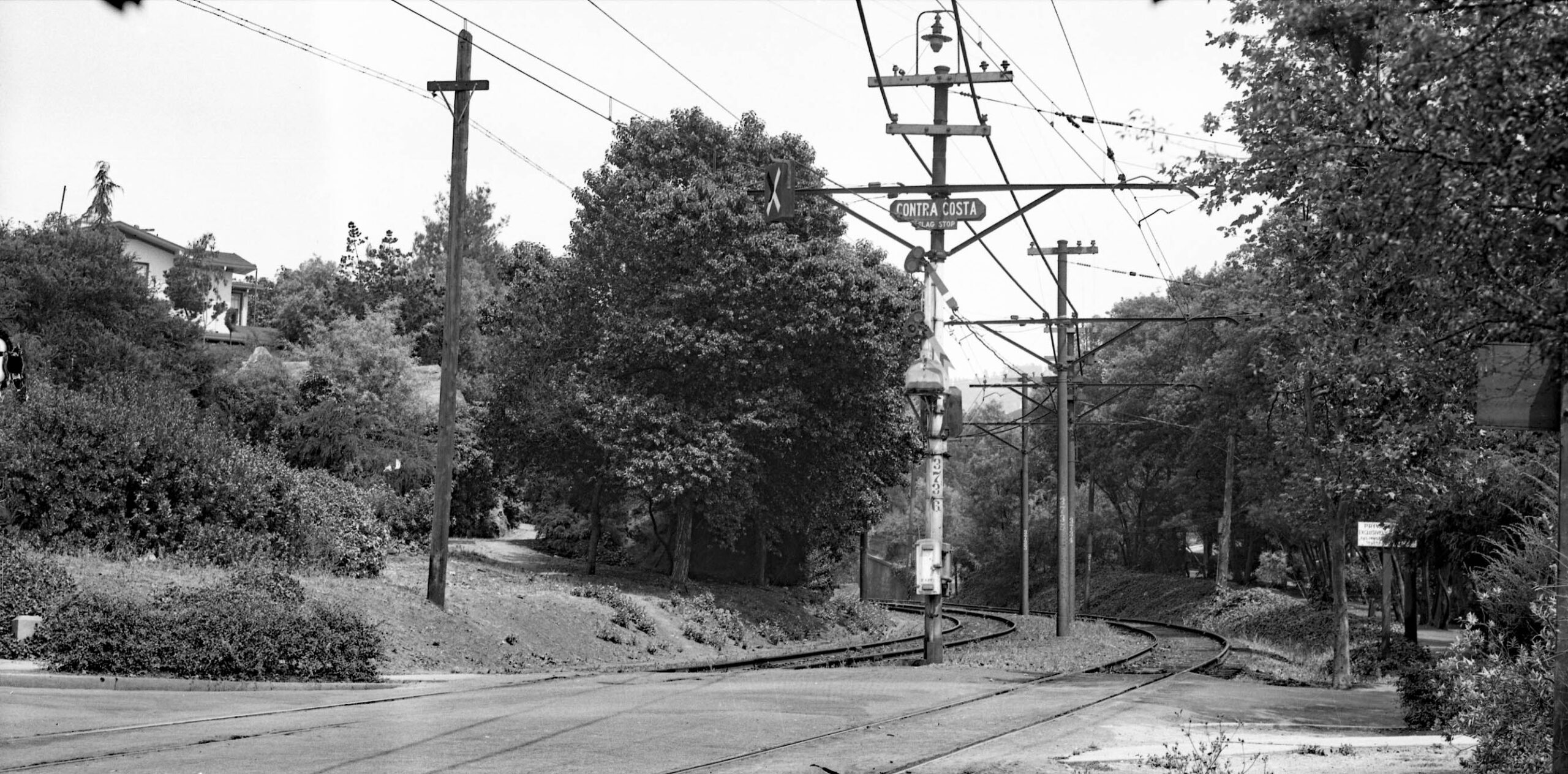
The Contra Costa Ave. stop was on the west side of the tunnel as seen in this southeast view from 1934. The short private right-of-way extended from the inside of the tunnel to beyond here to The Alameda. This section would later be converted to Solano Ave. to be reviewed in a later update.
L352-90-SP Official Photo, Sappers Collection, Courtesy BAERA, Western Railway Museum Archives, 170920oa&b, (Image 19 of 25)
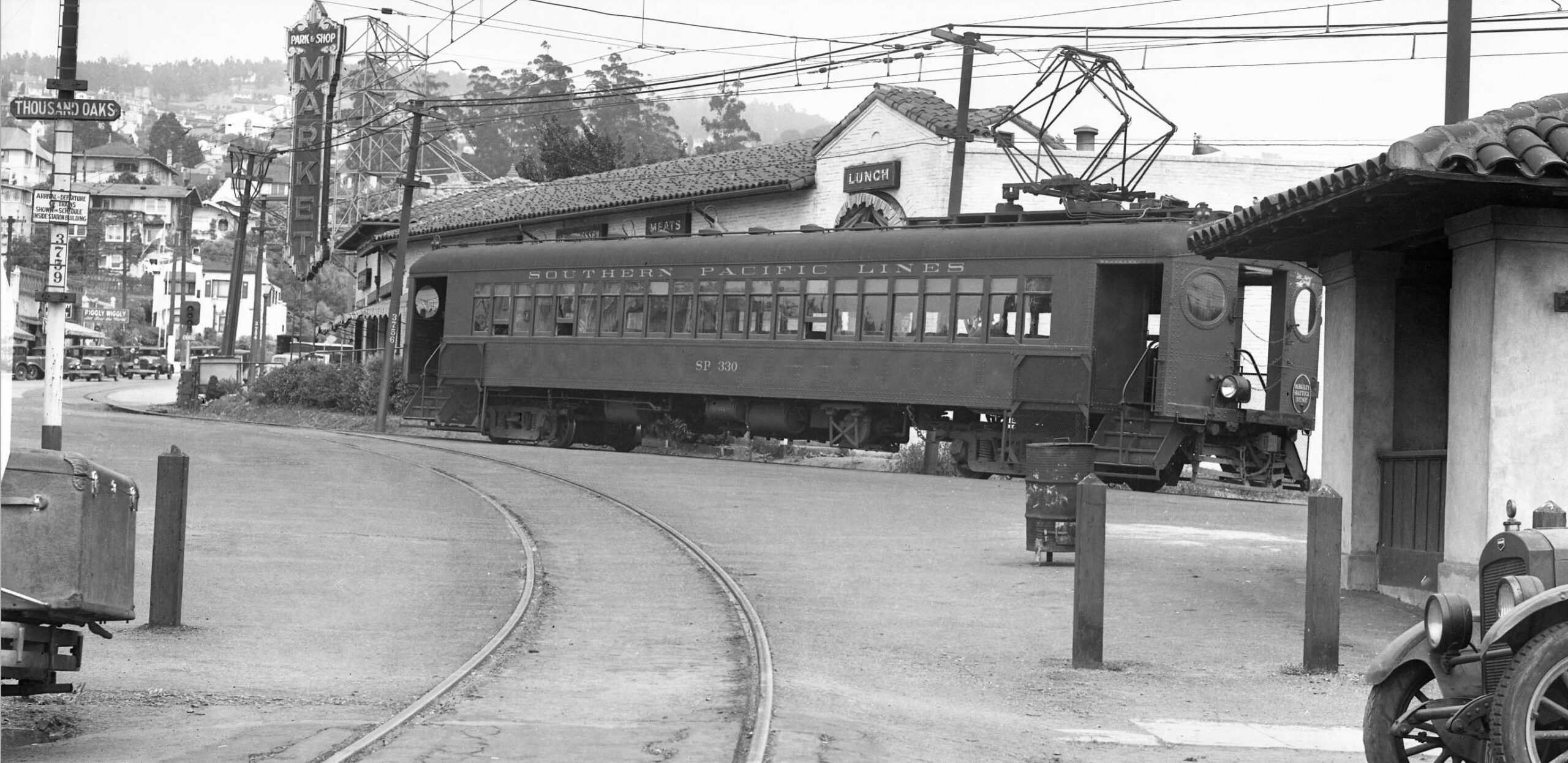
Finally at the terminus, the tour from 1934 ends with an east view at the Thousand Oaks station and shelter, the latter partially seen on the right. A Shattuck train, SP 330, waits for passengers. The track in the foreground is the connector to the two double wyes at Colusa Ave.
L352-95-SP Official Photo, Sappers Collection, Courtesy BAERA, Western Railway Museum Archives, 170940oa&b, (Image 20 of 25)
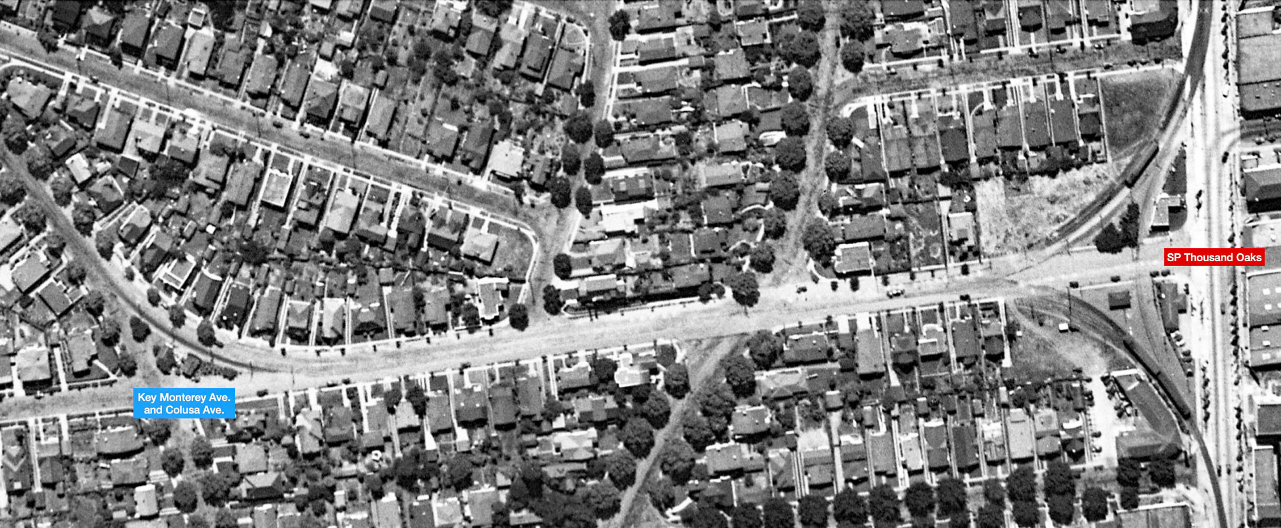
The aerial shows that the distance between the what became the northern termini of the Key Northbrae line and the SP Thousand Oaks Station is but a short walk, certainly not eliminating competition in the western section of Northbrae. Considering the changes to the Key and SP, did one railway gain more financially over the other from the CE and the bridge operation? Harre Demoro wrote in his book “The Key Route”, Interurban Press, 1985, that the Key lost more. It had newer ferries and had to give up its pier and trestle. The SP would lose the Alameda Pier that would have a negative impact on traffic to Alameda, but they retained the Oakland Pier for steam operations beyond the Bay that allowed ferries to San Francisco.
L352-100-Harrison Ryker Photo, Copyright California Department of Transportation, (Image 21 of 25)
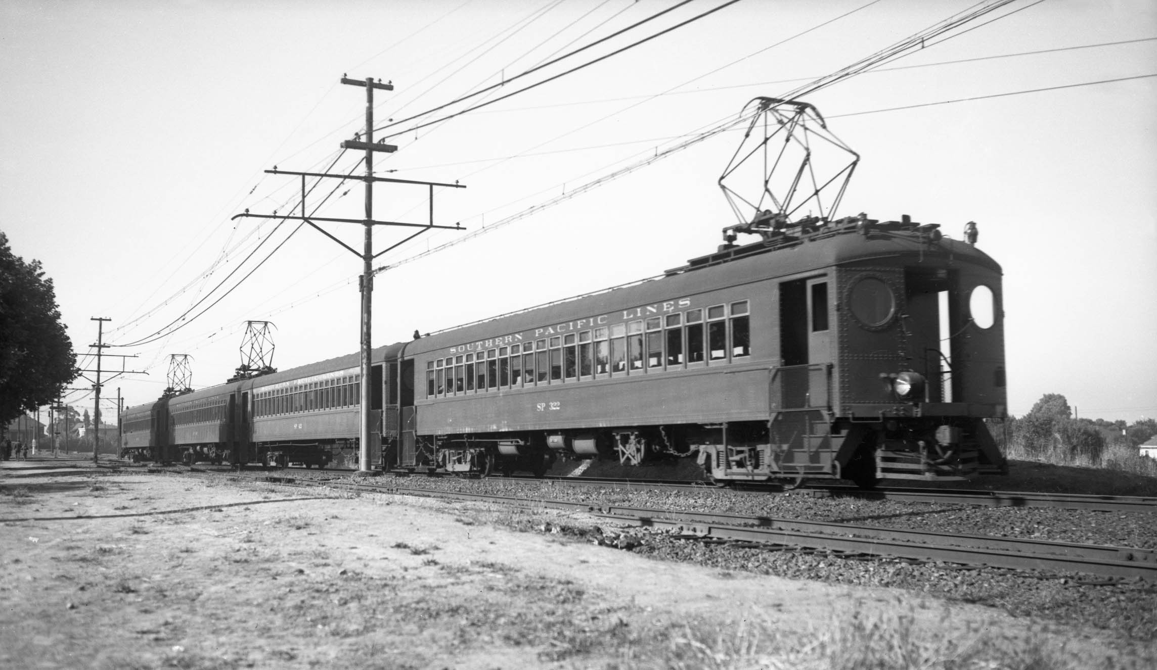
Railfan Will Whittaker took several photos in 1937 of portions of the Shattuck line not covered in the right-of-way images of station stops shown in this presentation. These images also document the short period between the CE changes and the opening of the Bay Bridge. In this northeast view, SP 322 and three trailers pass the SP Berryman yard on the way to Berryman station seen in the distance.
L352-105-Wilbur C. Whittaker Photo, Harry Aitkin Collection, Courtesy BAERA, Western Railway Museum Archives, 165095oa&b, (Image 22 of 25)
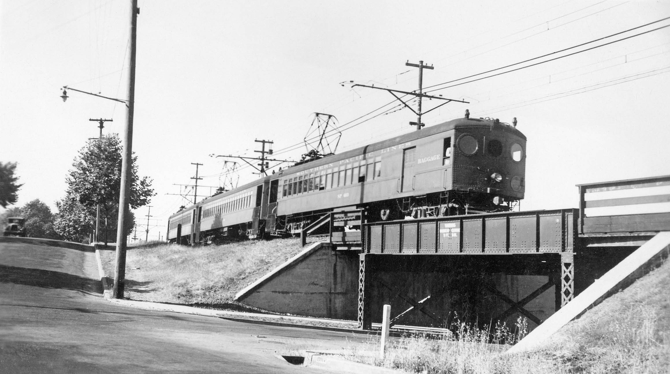
Next, a northeast view of SP 603 and two trailers on the Eunice St. overpass.
L352-110-Wilbur C. Whittaker Photo, Robert S. Ford Collection, Courtesy BAERA, Western Railway Museum Archives, 170336oa&b, (Image 23 of 25)
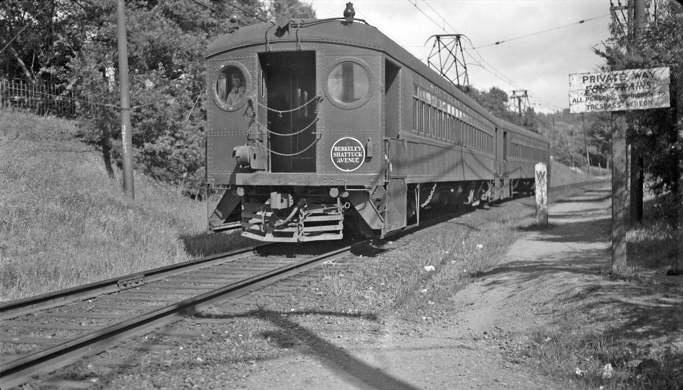
This southeast view at The Alameda where the private right-of-way ended to become Solano Ave. shows a two-car train on a single track. A photo from 1923 shown in a previous update showed two tracks at this juncture. Although not specifically mentioned by Ford in his book, this transition occurred sometime during this interval, possibly with the conversion to a single track along Solano Ave. west of the Thousand Oaks station.
L352-115-Wilbur C. Whittaker Photo, Robert M. Hanft Collection, BAERA, Western Railway Museum Archives, 54987oa&b, (Image 24 of 25)
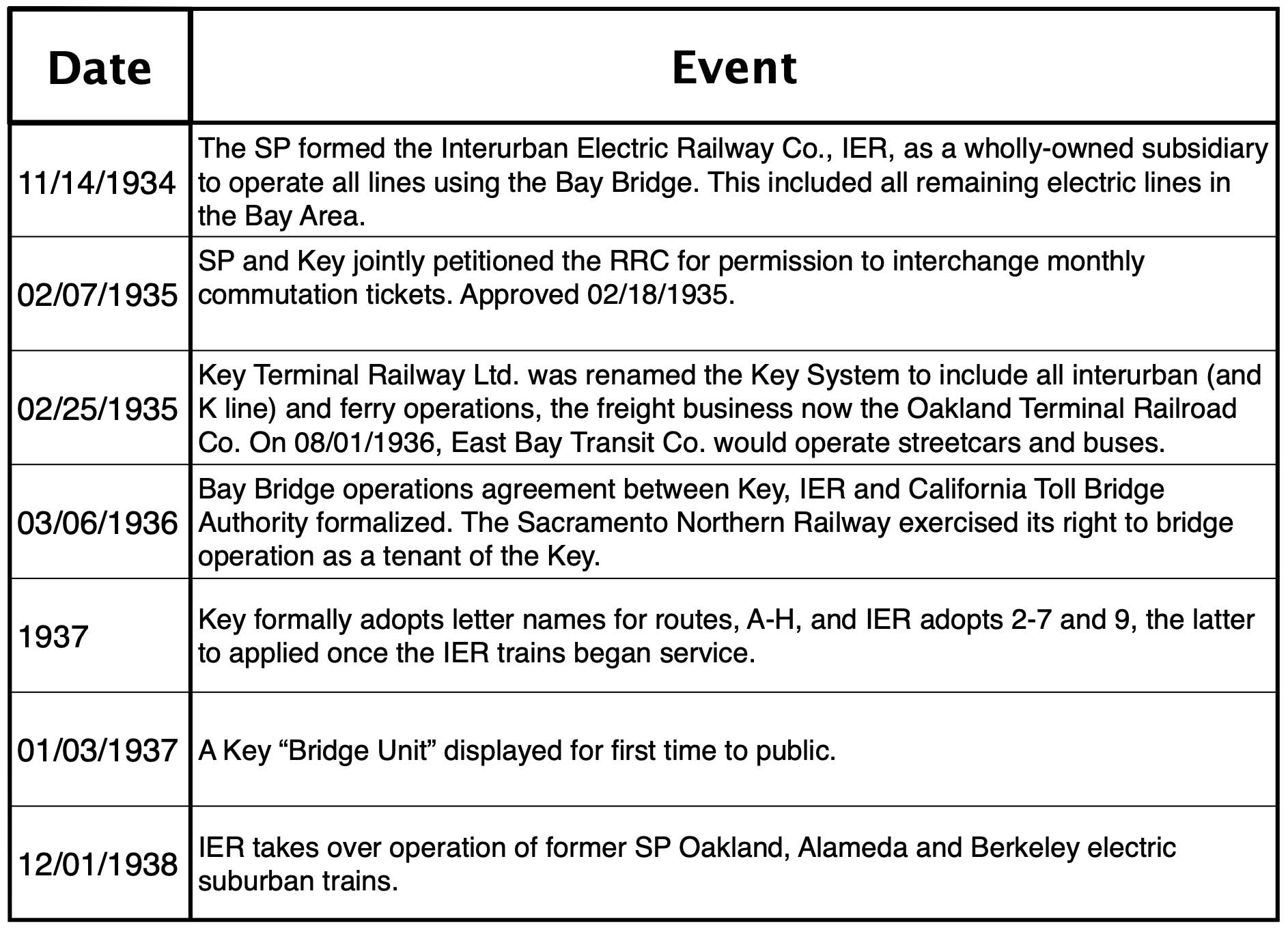
Between the enactment of the CE and the beginning of Bay Bridge operation, several important events occurred for the Key and the SP that are summarized in this table with information extracted from Ford’s and Demoro’s books. Not every detail is covered, but the dates indicate that getting the formal agreement agreed to by the railways took over three years to achieve, the SP the biggest holdout. Next time, the most striking images from the Bay Bridge era, 1939-1941.
L352-120-Compiled by Stuart Swielder, (Image 25 of 25)