Crossing the Freeway II – Views From the Hill

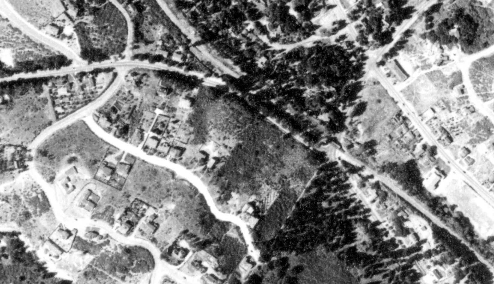
Before the first section of Mountain Boulevard Freeway (MBF) could be completed, the hill bordering Moraga Road had to be drastically reduced in elevation to accommodate the future extension of the freeway through Montclair. Aerial, Aug. 2, 1939. Annotated version follows.
L46-05-USDA AAA Western Division, BUT BUU-289-44, Detail , (Image 1 of 14)

Annotated version of L46-05. The area of the hill to be reduced in elevation is surrounded by the dotted red line. Aerial, Aug. 2, 1939.
L46-06-USDA AAA Western Division, BUT BUU-289-44 Detail , (Image 2 of 14)

Preconstruction north view, circa 1949-50, from the hill shows only one home, and, to the right, one pole with electrical wires along Moraga Avenue. The large eucolyptus tree in the center of the image, at the intersection of Florence Avenue with the right-of-way, will serve as a marker.
L46-10-Public Works Photos, Oakland Cultural Heritage Survey, Oakland City Planning Department, (Image 3 of 14)

A minimal amount of work has begun, and more homes are revealed. North view, circa 1950-51.
L46-15-Public Works Photos, Oakland Cultural Heritage Survey, Oakland City Planning Department, (Image 4 of 14)

Excavation has begun in earnest in this north view, circa 1950-51. The homes on Estates Drive above the right-of-way now come into view, just left of center, while Moraga Avenue can be seen at the right of the image. A detail from the background center follows.
L46-20-Public Works Photos, Oakland Cultural Heritage Survey, Oakland City Planning Department, (Image 5 of 14)

Detail from L46-20 brings the homes on Estates Drive into view, left, the SN right-of-way, center, and the homes on Fernwood Drive that survived the emergence of the freeway, right. At this point, the SN catenary pole toward the bottom right is separated from the hill by Moraga Avenue. Circa 1950-51.
L46-25-Public Works Photos, Oakland Cultural Heritage Survey, Oakland City Planning Department, (Image 6 of 14)

Turning more to the northeast, a small portion of Moraga Avenue north of its intersection with Thornhill Drive is visible in this preconstruction view, circa 1949-50.
L46-30-Public Works Photos, Oakland Cultural Heritage Survey, Oakland City Planning Department, (Image 7 of 14)

A view of Moraga Avenue becomes more prominent up to the freeway crossing as reduction of the hill proceeds in this northeast view, circa 1950-51.
L46-35-Public Works Photos, Oakland Cultural Heritage Survey, Oakland City Planning Department, (Image 8 of 14)

Turning to the southeast prior to construction, circa 1949-50, a truck on Moraga Avenue has just passed the barely visible SN Thornhill Drive trestle. The remainder of Moraga Avenue is still obscured below the homes on the eastern flank above central Montclair.
L46-40-Public Works Photos, Oakland Cultural Heritage Survey, Oakland City Planning Department, (Image 9 of 14)

With reduction of the hill in progress, the Thornhill Drive trestle can be seen in full, and Moraga Avenue can be seen extending just past the gingerbread-like fire station at the right edge of the image. Southeast view, circa, 1950-51.
L46-45-Public Works Photos, Oakland Cultural Heritage Survey, Oakland City Planning Department, (Image 10 of 14)

With more of the hill removed, the graded portion of the future freeway south of Moraga Avenue can be appreciated in this northeast view, circa 1951. Although often linked with the first phase of the MBF, this section did not open to traffic until completion of the second phase in Oct. 1956. A more detailed view follows.
L46-50-Public Works Photos, Oakland Cultural Heritage Survey, Oakland City Planning Department, (Image 11 of 14)

The future freeway continues to be graded south toward Thornhill Drive. The right-of-way is now completely exposed on its west flank. Northeast view, circa 1951.
L46-55-Public Works Photos, Oakland Cultural Heritage Survey, Oakland City Planning Department, (Image 12 of 14)

Detail of L46-55. Recall that the SN abandoned this portion of the right-of-way on Mar 1, 1957. Northeast view, circa 1951.
L46-60-Public Works Photos, Oakland Cultural Heritage Survey, Oakland City Planning Department, Deta, (Image 13 of 14)

Images such as this circa 1956 southeast view showing the potential of the SN to bring all traffic to a halt should also remind us that Moraga Avenue was a barrier to freeway traffic well into 1963, or 6 years after abandonment of the SN right-of-way. More on this subject soon.
L46-65-Western Pacific Photo, Courtesy BAERA, Western Railway Museum Archives, 61348sn , (Image 14 of 14)