Dating the Havens Shelter

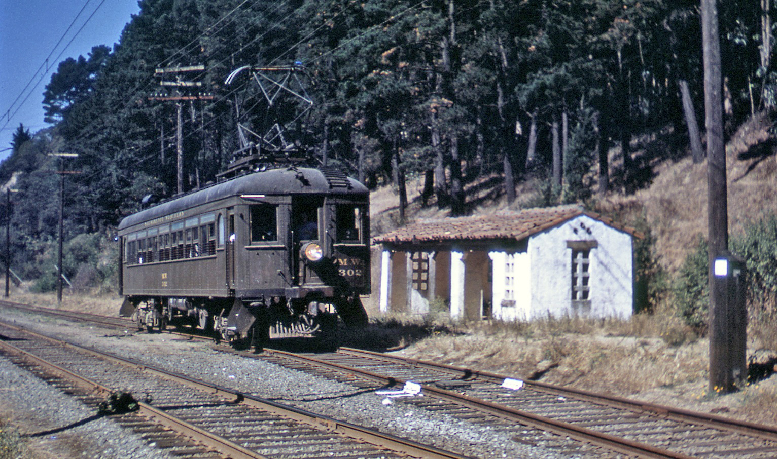
The shelter at Havens was not built by the railroad, and barring presumptions written concerning its origins, the pictorial documentation has not been systematically presented. The first question is whether it was built by Frank Havens, the Realty Syndicate, of someone else? Northwest view with MW 302, 1948.
L64-05-Robert T. McVay Photo, Courtesy BAERA, Western Railway Museum Archives, 67511sn, (Image 1 of 14)

Prior to the 1930s, the listing of Havens as a flag stop appears on timetable number 8, Jan. 3, 1915. An east view from 1925 shows no associated shelter. Note that the block signals are further east than in later images. Frank Havens died in 1917, but his son Wickham developed this area as part of the Forestlands Heights tract in 1926.
L64-10-Harry A. Mitchell Photo, Sappers Collection, Courtesy BAERA, WRM Archives, 57469sn , (Image 2 of 14)

A building permit for the one-story “shed”, number A40591 dated Sept 25, 1929, shows the owner as Wickham Havens and the builder as O.W. Thornton. The cost of construction was $500. This west view, pre-1939, from a SN parlor car is the earliest evidence of the shelter from images found so far. Credit to Gail Lombardi and the Oakland Cultural Heritage Survey, again.
L64-15-Courtesy BAERA, Western Railway Museum Archives, 59246.3sn, (Image 3 of 14)

Now turing to the shelter’s longevity, this west view of SN 652 reaching the Paso Robles Dr. grade crossing on Feb. 2, 1957 confirms that the shelter did not survive SN abandonment at this site at the end of that month.
L64-20-Richard Kampa Photo, Courtesy BAERA, Western Railway Museum, 58320sn , (Image 4 of 14)

Images dated from Dec. 1956 such as this north view indicated a large amount of public works activity in this section ...
L64-25-Public Works Photos, Oakland Cultural Heritage Survey, Oakland City Planning Department, (Image 5 of 14)

... extending northward up Paso Robles Drive. Dec., 1956.
L64-30-Public Works Photos, Oakland Cultural Heritage Survey, Oakland City Planning Department , (Image 6 of 14)

A south view of the extent of the project, again from Dec., 1956. The image was accompanied by the notation that the car observed on Park Blvd. belonged to Mrs. Martin.
L64-35-Public Works Photos, Oakland Cultural Heritage Survey, Oakland City Planning Department , (Image 7 of 14)

The clinching image, Dec. 1956, of a west view down Park Blvd. shows no shelter.
L64-40-Public Works Photos, Oakland Cultural Heritage Survey, Oakland City Planning Department , (Image 8 of 14)

Several east view images from excursions with SN 1005 and SLU 751 from mid-1956 to Jan. 1957 also show no shelter.
L64-45-Arthur Lloyd Photo, Courtesy Arthur Lloyd, (Image 9 of 14)

Here in color, no shelter, east view, mid-1956 to Jan. 1957.
L64-50-Courtesy Charles Smiley, (Image 10 of 14)

One last one, more color, still no shelter, east view, mid-1956 to Jan. 1957.
L64-55-Courtesy BAERA, Western Railway Museum Archives, 54976sn, (Image 11 of 14)

Traveling back in time, an excursion with SN 644 and MW 302, Nov. 29, 1953, also shows no shelter.
L64-60-Arthur Lloyd Photo, Courtesy Arthur Lloyd, (Image 12 of 14)

This northwest view, an excursion with SN 1005 and MW 302, July 6, 1952 shows the phone booth in the background by the grade crossing, and 7150 Woodrow Dr. towering above, but no shelter. This means that the shelter was removed sometime between 1948 and this date.
L64-65-Dudley Thickens Photo, Courtesy BAERA, Western Railway Museum Archives, 67535sn, (Image 13 of 14)

Dave Gumz shot this west view showing the shelter in disrepair or in the process of being razed. The image was not dated and inability to resolve sufficient details of the motor, caboose or SN employee at the rear prevent pinpointing the date more precisely than around 1950.
L64-71-Dave Gumz Photo, Courtesy BAERA, Western Railway Museum Archives, 67539sn, (Image 14 of 14)