Foreshadowing the Future
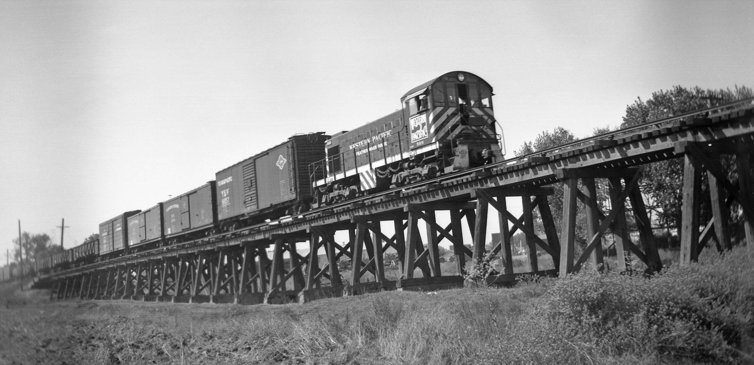
Dave Gumz drove his sport coupe out to North Sacramento to document Western Pacific ALCo S1 diesel switcher 509, WP 509, and freight on the Sacramento Northern Railway, SN, trestle over the American River floodplain in this undated southwest view. The contrast of the third rail with a WP diesel in the image depicts a time of change for the SN. This series of updates will provide transition images such as this one and document the key events that contributed to abandonment of mainline track north of Sacramento between city centers.
L311-05-Dave Gumz Photo, Courtesy BAERA, Western Railway Museum Archives, 103003sn, (Image 1 of 22)

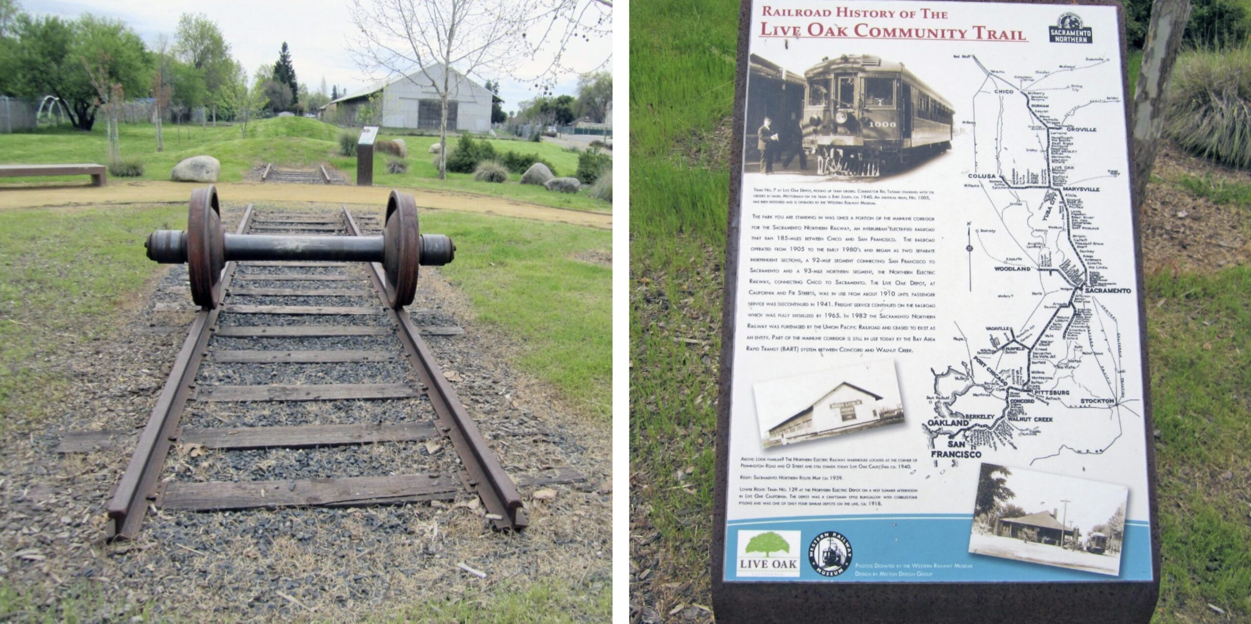
A trip to Live Oak reveals a tribute to the SN on a scale that cannot be found in any of the larger cities served north of Sacramento, known as the SN North End, during the 20th century. This section of updates will focus on the mainline and the Swanston and Reed Branches between the major city sites of Sacramento, Marysville, Yuba City, Oroville and Chico. Detailed photographic reviews of those cities may be found in other updates on this website. Click here.
L311-10-Courtesy Stuart Swiedler, (Image 2 of 22)
The North End had its own unique historical origin and focus relative to the portion below Sacramento, the South End. The former was more about dredging for gold, the latter about moving passengers. Aside from their acquisition and unification by the Western Pacific, WP, completed at the end of 1928, a general introduction of the earlier Northern Electric, NE, era is covered in a separate update. For even greater details, consult Ira Swett’s “Sacramento Northern”, Harry Demoro’s “Sacramento Northern”, or Jeff Asay’s “The Iron Feather”.
L311-15-Courtesy Stuart Swiedler, (Image 3 of 22)
Imagine encountering this freight carrying gold dredging equipment through Yuba City, purportedly on Bridge St. in this image, or navigating the tight turns at the 5th St.-D St. or D St.-2nd St. intersections in Maryville. The WP would satisfy regulatory requirements and gain control in 1925 of the North End, at that time the successor to the NE, the Sacramento Northern Railroad, SNRR, and executed a plan to keep freights off the city streets in Marysville.
L311-20-Courtesy BAERA, Western Railway Museum Archives, (Image 4 of 22)
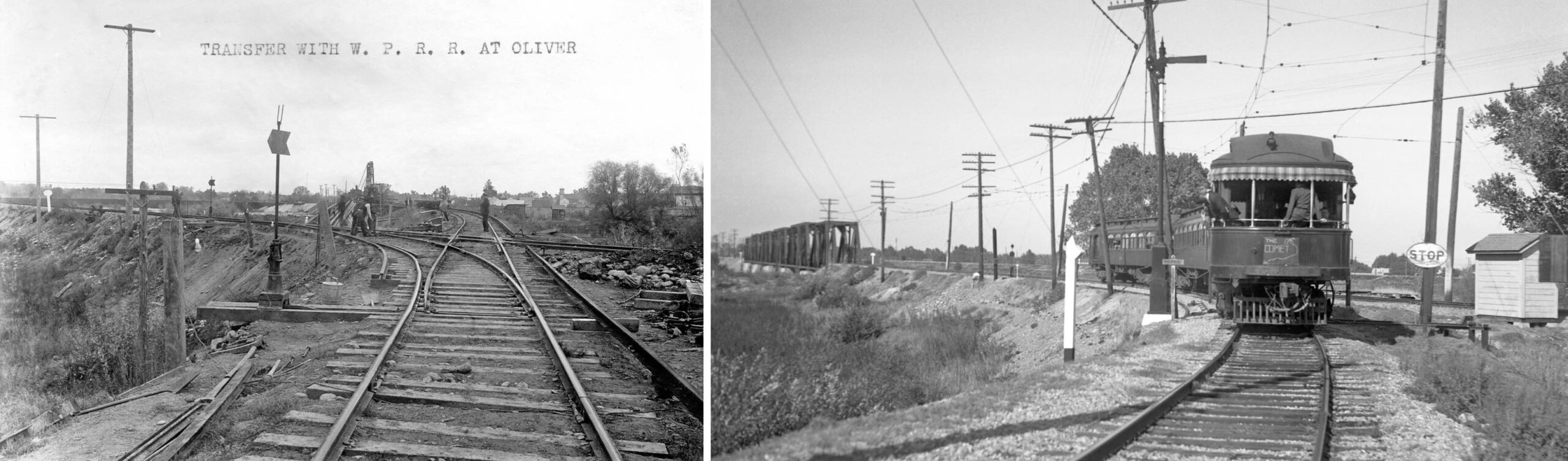
Sometime in 1925-1926, the WP eliminated the SNRR bridge over the Yuba River, a bridge whose condition was of concern, and tied in the SNRR into the WP mainline at Oliver as shown in the before, left from Nov. 23, 1909, and after, right from Oct. 27, 1940, images. Once in Marysville, track was added to put the passenger trains back onto city streets, and keep freights off the streets and in position to serve all SN-WP switching operations in Marysville and Yuba City. These changes made economic and operational sense, but at the expense of the SNRR losing its individual identity. More details at this update.
L311-25-Courtesy BAERA, Western Railway Museum Archives, 224631, l, Wilbur C. Whittaker Photo, Vielbaum Coll., 132837, r, (Image 5 of 22)
Interurban passenger service was not a priority of the WP, but the new Union Station did open in the fall of 1925, this a northeast view, 1937. The SN was the only user by 1933. Termination of passenger service in the North End in Vacaville in 1927, in West Sacramento in 1924, and in Swanston in 1932 had minimal impact on total trackage, and the loss of the Vacaville branch into Suisun was later compensated when the isolated segment was connected to South End track via new track between Vacaville Junction and Creed.
L311-30-Wilbur C. Whittaker Photo, Walt Vielbaum Coll., Courtesy BAERA, Western Railway Museum Archives, 132871sn, (Image 6 of 22)
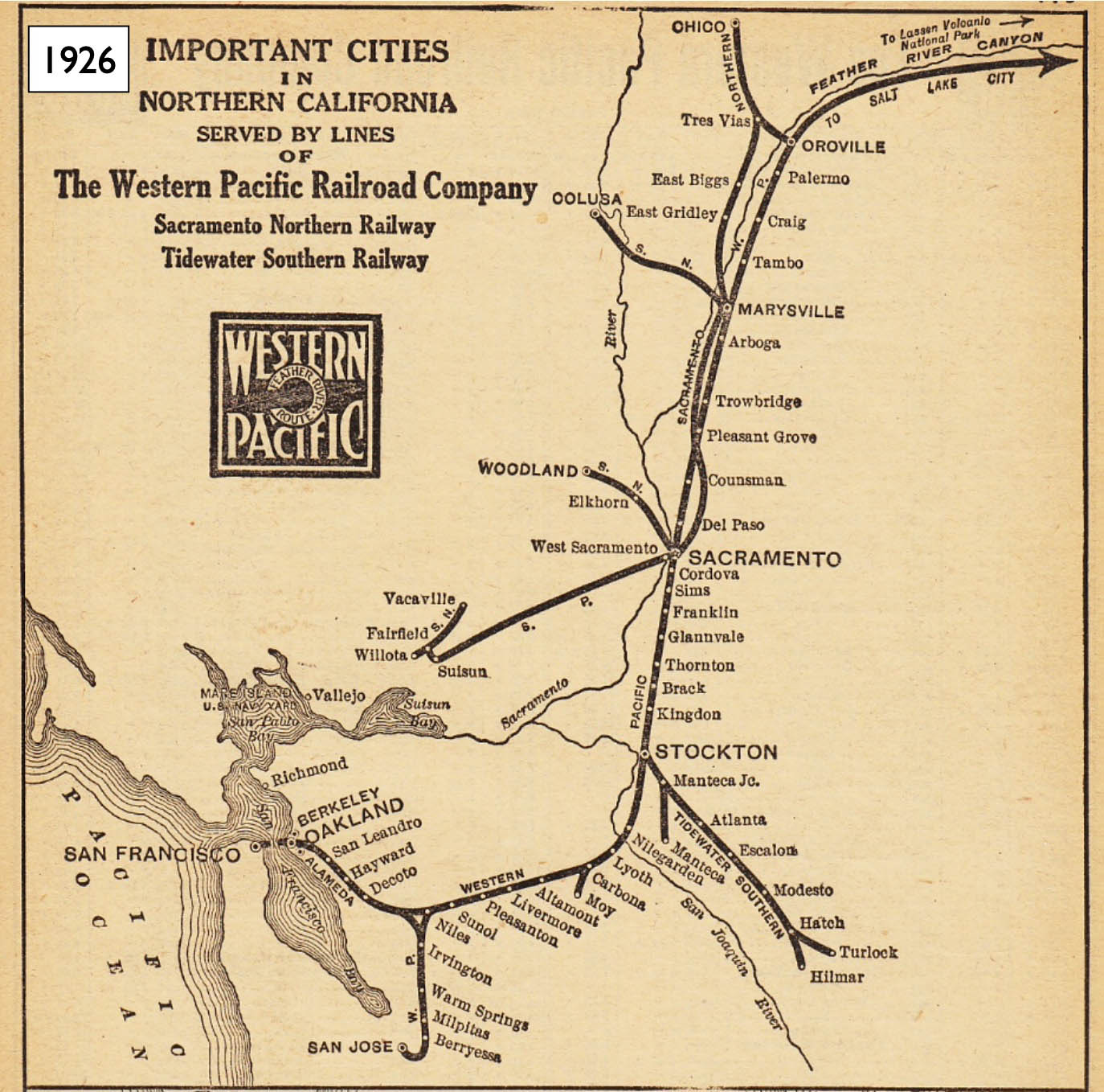
With a joint WP-SNRR effort in Marysville solidified, a review of this map from 1926 brings out the apparent closely parallel trackage between Sacramento and Marysville. While this will become a central issue several decades later, the seed was planted for the most economical and efficient operation between the two cities in 1928.
L311-35-Poole Bros. Chicago, Moreau Collection, Courtesy BAERA, Western Railway Museum Archives, (Image 7 of 22)
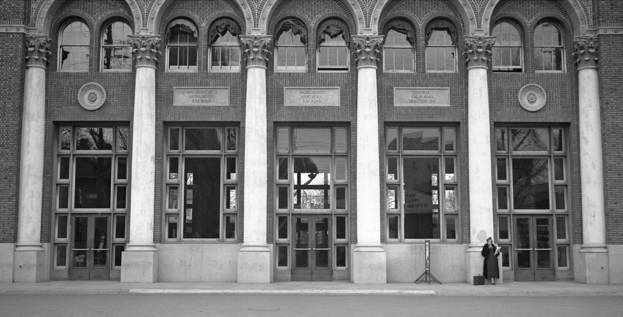
With the impending unification of North and South Ends as 1928 progressed, the WP Engineering Dept. sought to determine the best organization of WP and SN freight operations in Sacramento. Ahead to this southwest view from Apr. 21. 1949, WP and SN operations stayed virtually unchanged, but close in proximity in Haggin Yard, and both bridges over the American River remained. WP tracks are on the left or east, SN tracks on the right or west, SP yard toward the right edge or west, with an overpass of of SN and WP lines, and interchange with the SN.
L311-40-Copyright California Department of Transportation, 1498-3, (Image 8 of 22)
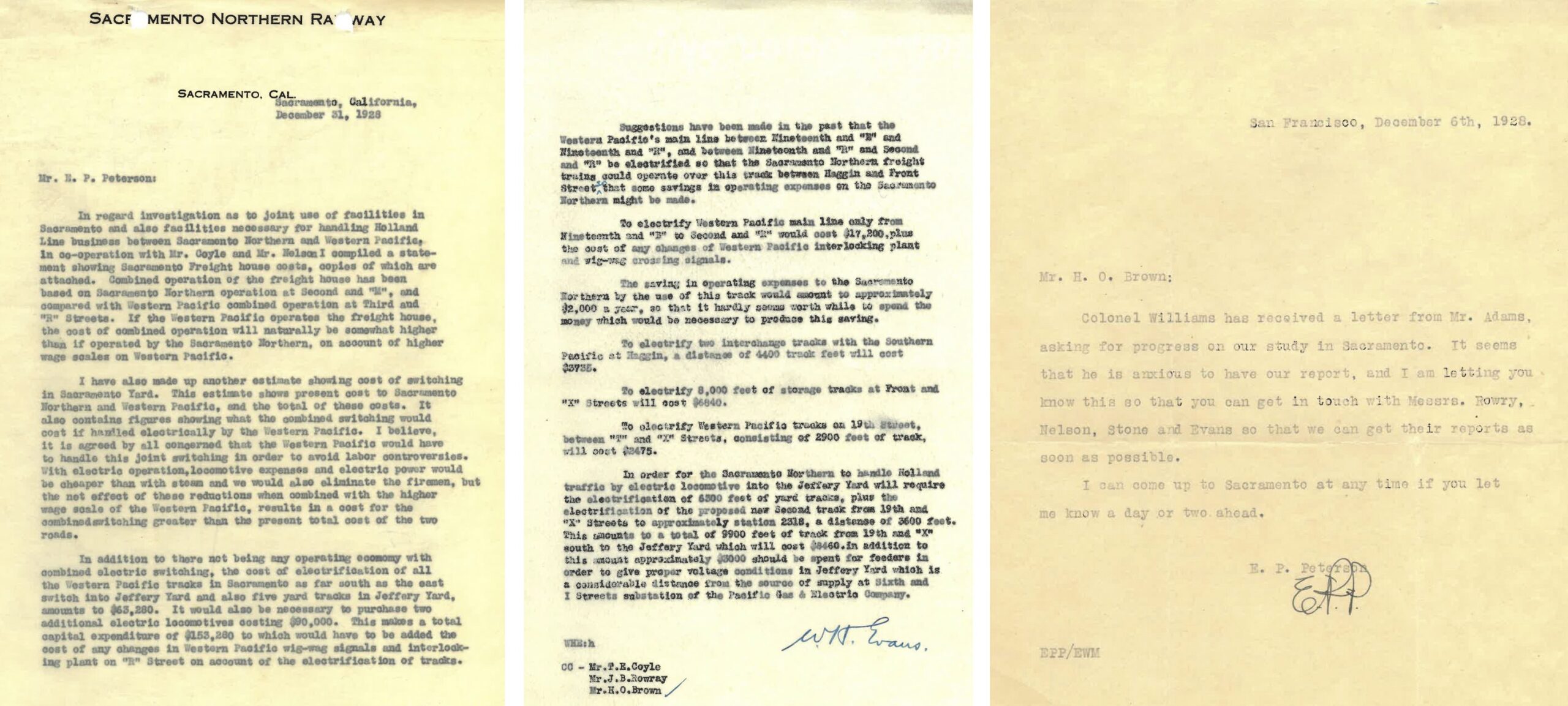
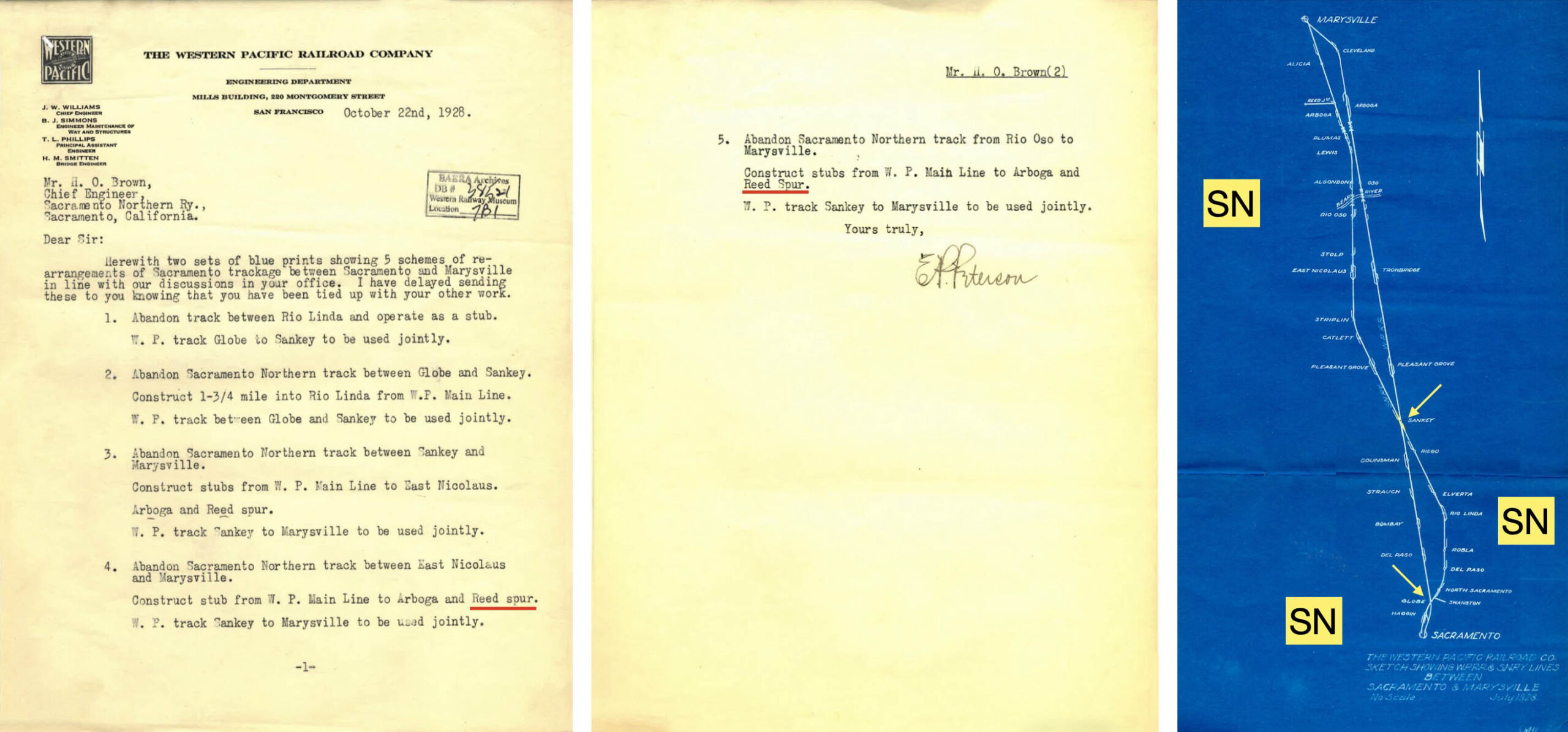
Next for the documentation of the tactical exchange between WP and SN engineering groups. The letter from SN Electrical Engineer to his WP counterpart suggests that not much would happen to significantly change the footprint of either railroad in Sacramento. On the right, Harry M. Adams was president of the WP from 1927-1931, and Col. J. W. Williams was the WP Chief Engineer.
L311-45-Courtesy BAERA, Western Railway Museum Archives, 38521, (Image 9 of 22)
Elimination of either railroad bridge was also not going to happen as well. For those interested in the nitty-gritty of operations in Sacramento, the document on the right continues for 15 more pages, but will not be presented here as the information does not have any bearing on the topic at hand.
L311-50-Courtesy BAERA, Western Railway Museum Archives, 38521, (Image 10 of 22)
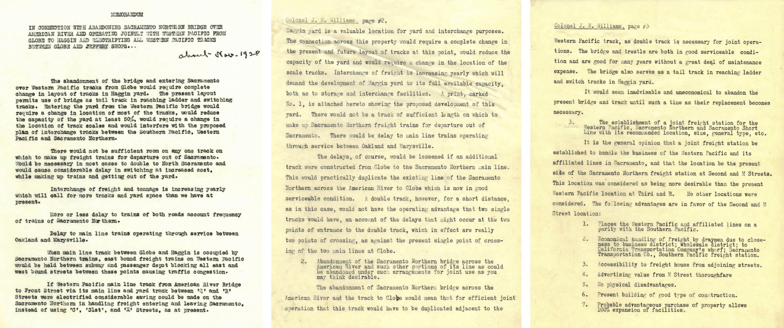
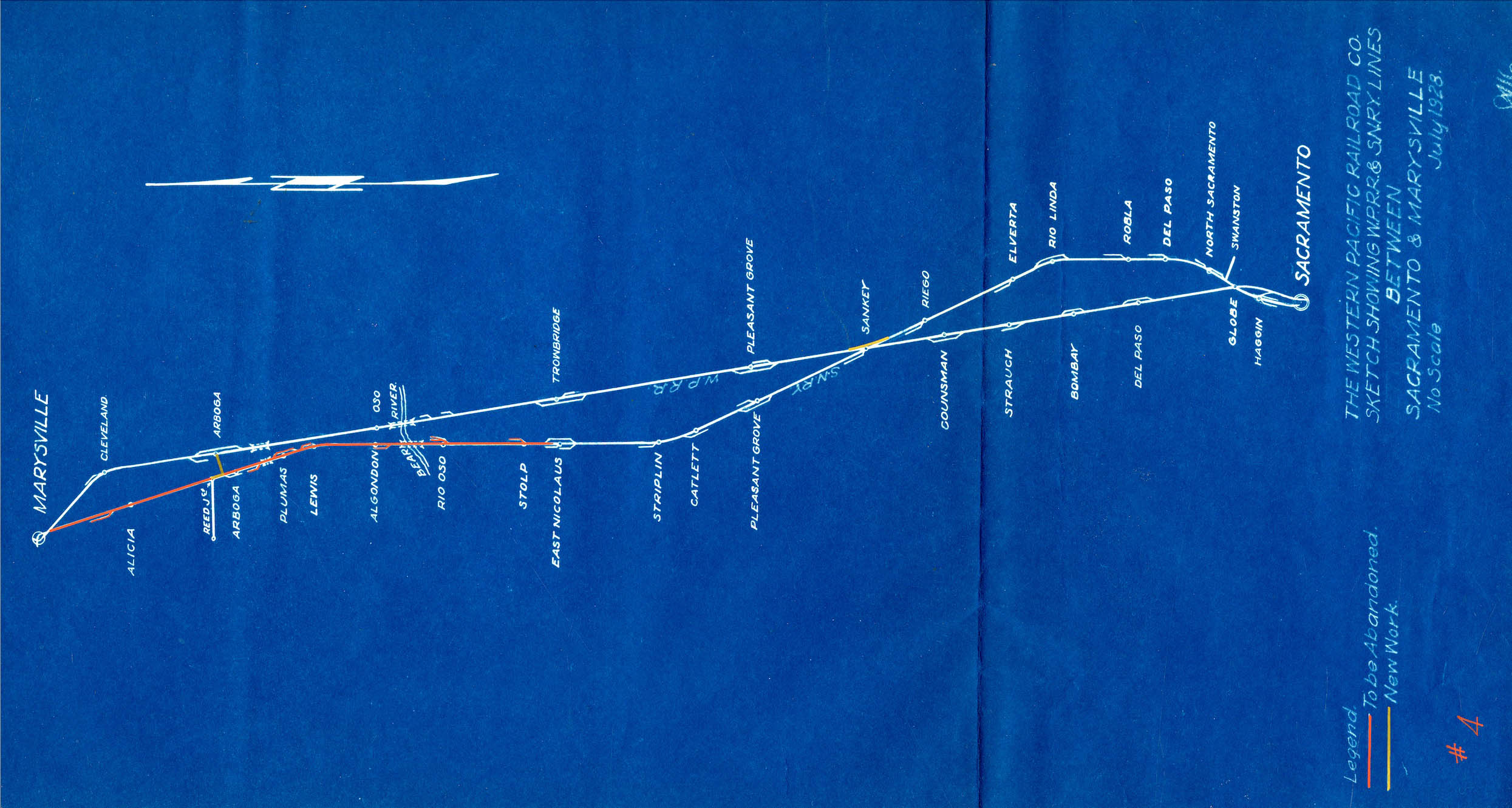
As far as foreshadowing the future of the SN between Sacramento and Marysville, the document on the left shows the desire of the WP from the get-go to eliminate whatever SN trackage possible while maintaining important freight customers without concern for its impact on SN interurban passenger service. Note the reference to the “Reed spur”, a subject that will become important in a future update in this series. The map on the right shows the crossover of the two lines at Globe and Sankey, and the track arrangement at each station.
L311-55-Courtesy BAERA, Western Railway Museum Archives, 38521, (Image 11 of 22)
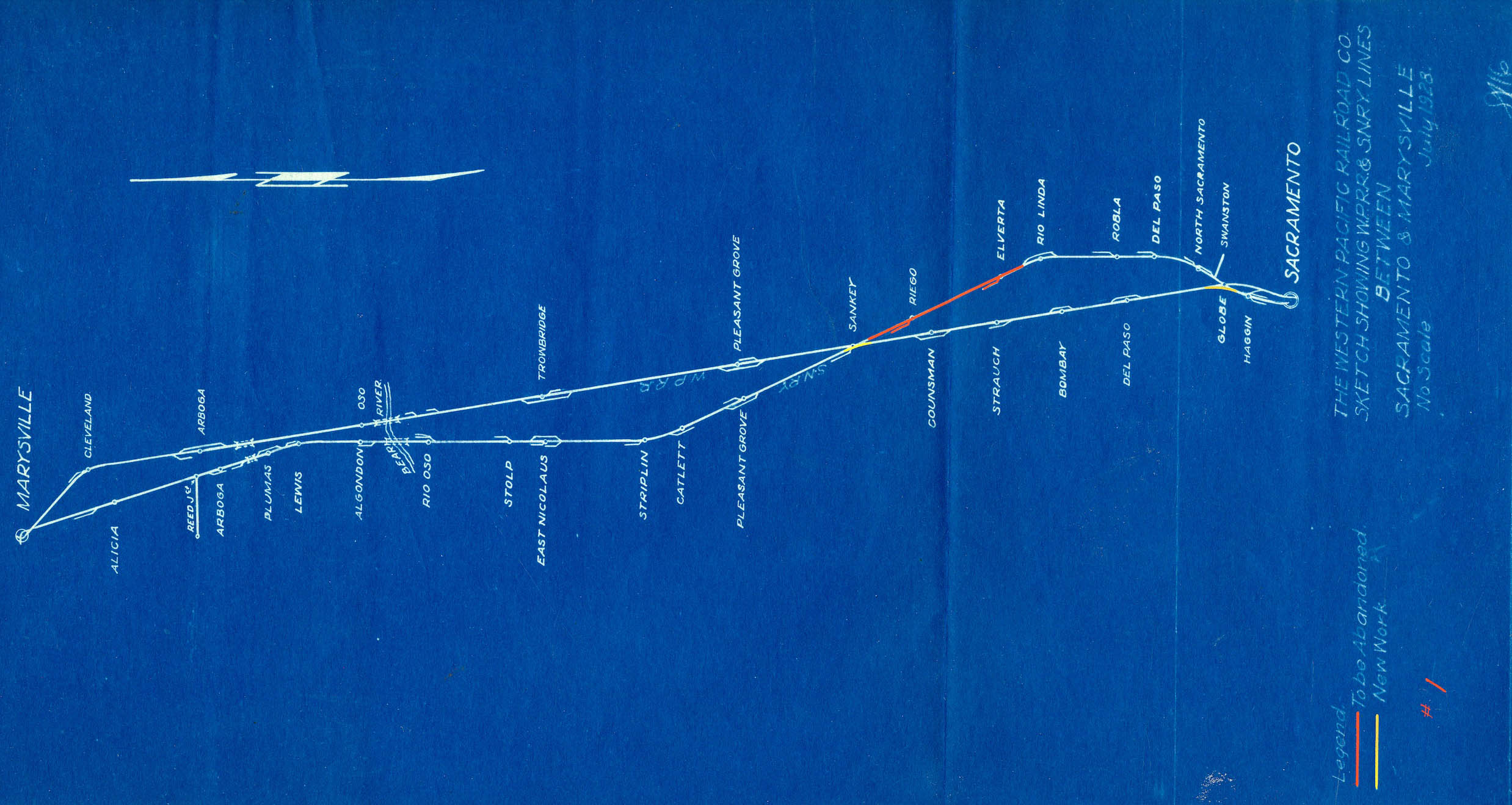
Each plan from July 1928 has been rotated 90 degrees counterclockwise to project the largest image possible. Scheme 1 would have resulted in creating a branch between Sacramento and Rio Linda, the latter a relatively important site of SN freight customers with Rio Linda Poultry Products and Rio Linda Lumber Co. having capacity for 9 cars total. This segment was the focus of protest to remove the third rail by the growing surrounding community.
L311-60-Courtesy BAERA, Western Railway Museum Archives, 132037sn, (Image 12 of 22)
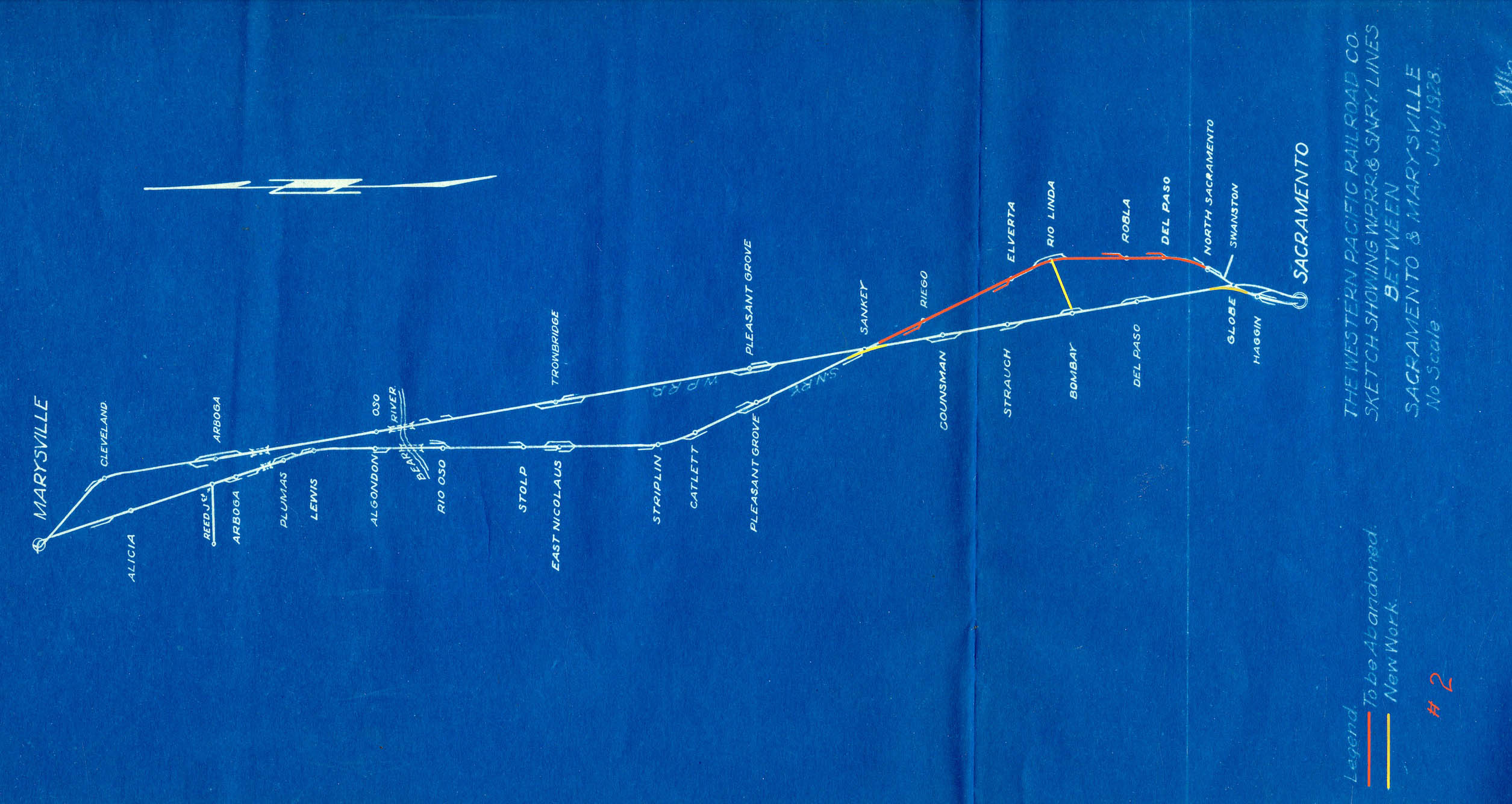
Scheme 2 drives the previous scheme to its extreme, basically preserving only Rio Linda and eliminating all of the SN between Sankey and North Sacramento. This view never gained any traction.
L311-65-Courtesy BAERA, Western Railway Museum Archives, 132039sn, (Image 13 of 22)
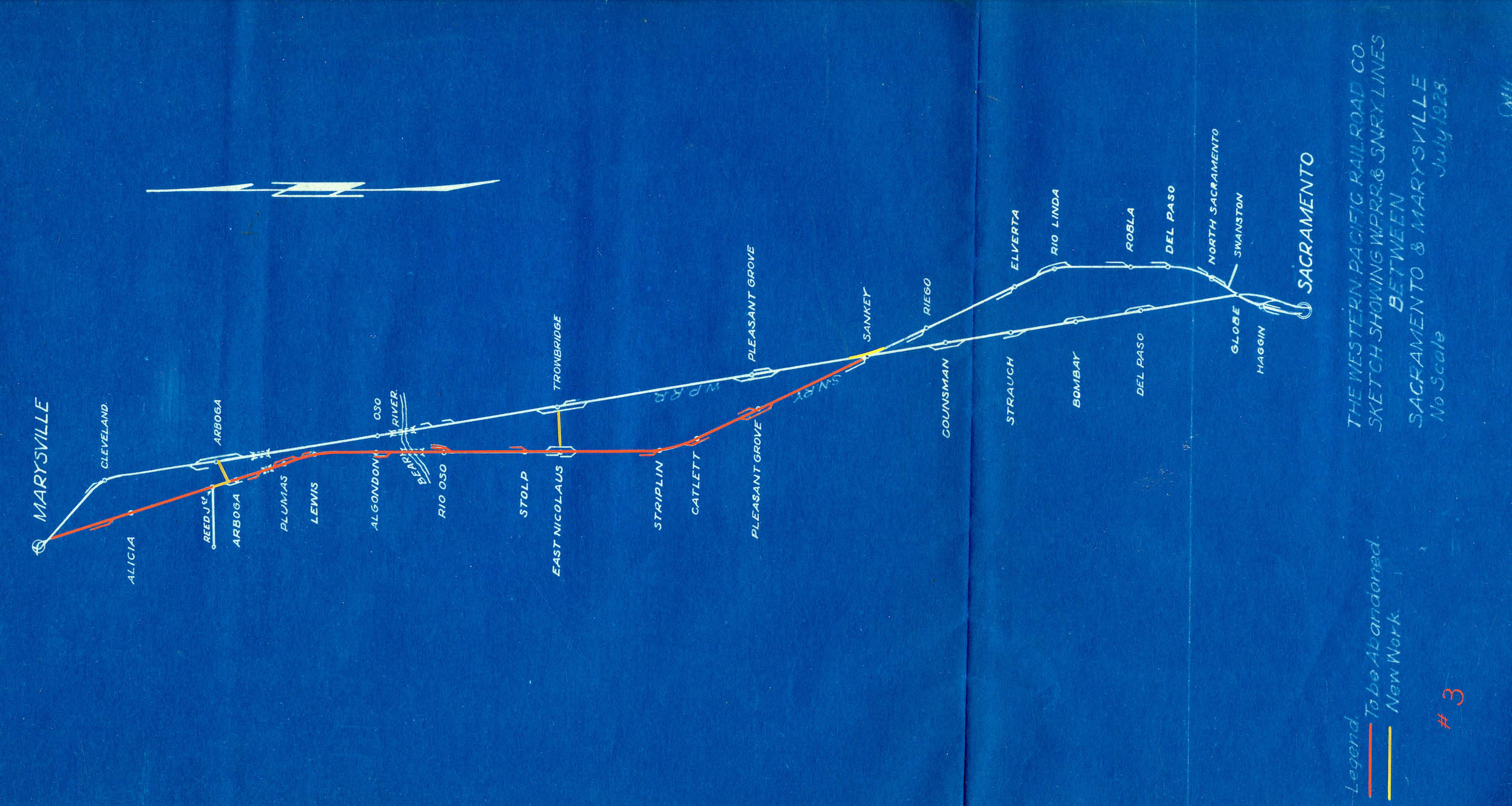
Scheme 3 is similar to the last one, but applied to the two freight customers north of Sankey. The spur to Reed Jct. here will become relevant, but driven by a non-railroad event to be discussed later. Note how Schemes 2 and 3 together would reduce the whole section of the SN north of Sacramento to short spurs-branches facilitating freight at Reed, East Nicolaus, Rio Linda and Swanston. Maybe that scheme would have been viewed as too obtrusive to present at this sensitive time.
L311-70-Courtesy BAERA, Western Railway Museum Archives, 132038sn, (Image 14 of 22)
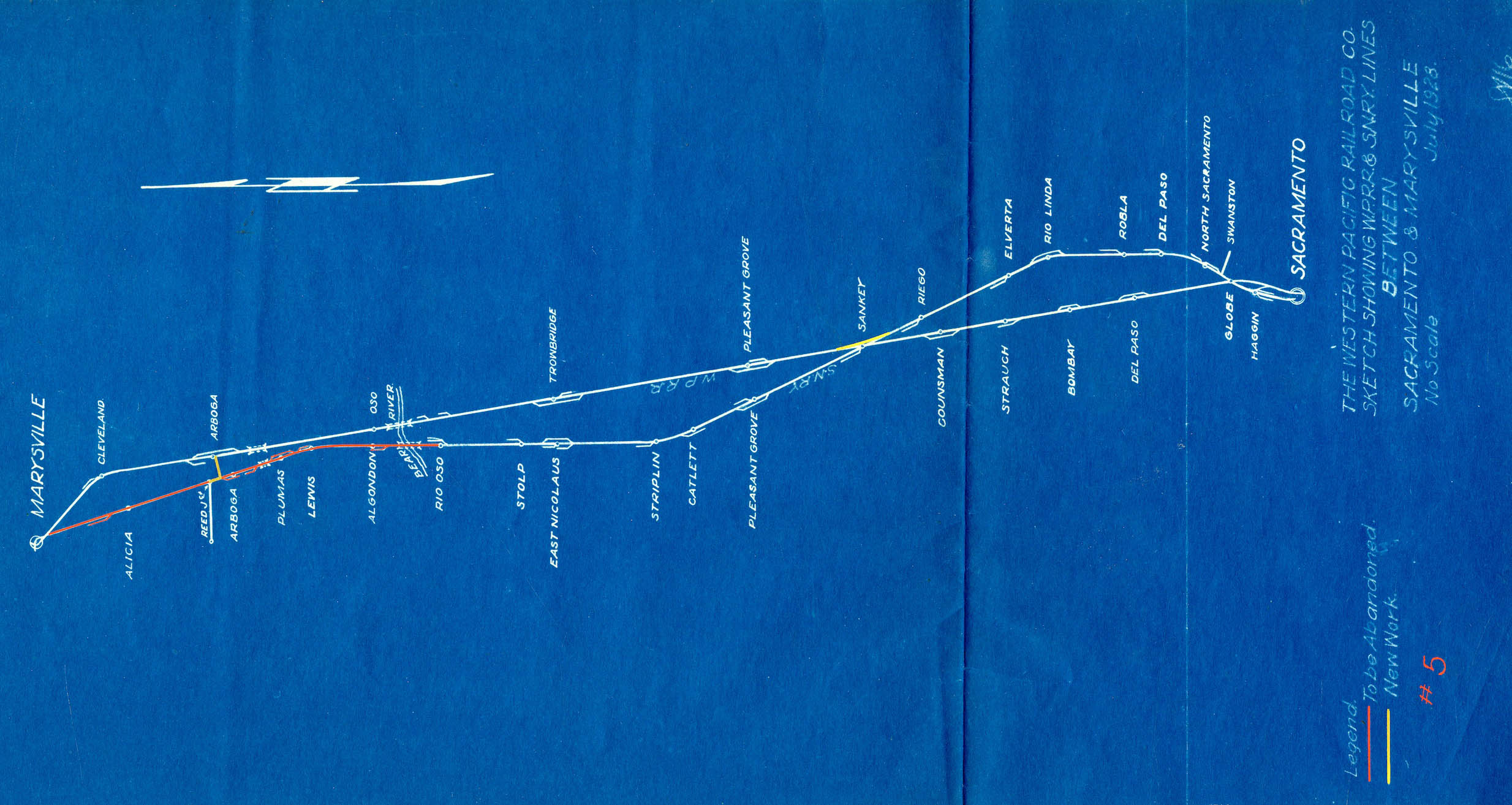
E. P. Peterson might have used a crystal ball to propose Scheme 4, roughly the state of affairs starting Oct. 15, 1958 when the SN would abandon the track between East Nicolaus and Alicia. Trains would run on WP track between Sankey and Cleveland or Marysville and Cleveland to access the Reed spur. Sankey to East Nicolaus was now a branch. Much more on how this came to be in a coming update.
L311-75-Courtesy BAERA, Western Railway Museum Archives, 132040sn, (Image 15 of 22)
Scheme 5 is a slightly more generous variation of Scheme 4, allowing servicing agricultural areas south to Rio Osso.
L311-80-Courtesy BAERA, Western Railway Museum Archives, 132041sn, (Image 16 of 22)
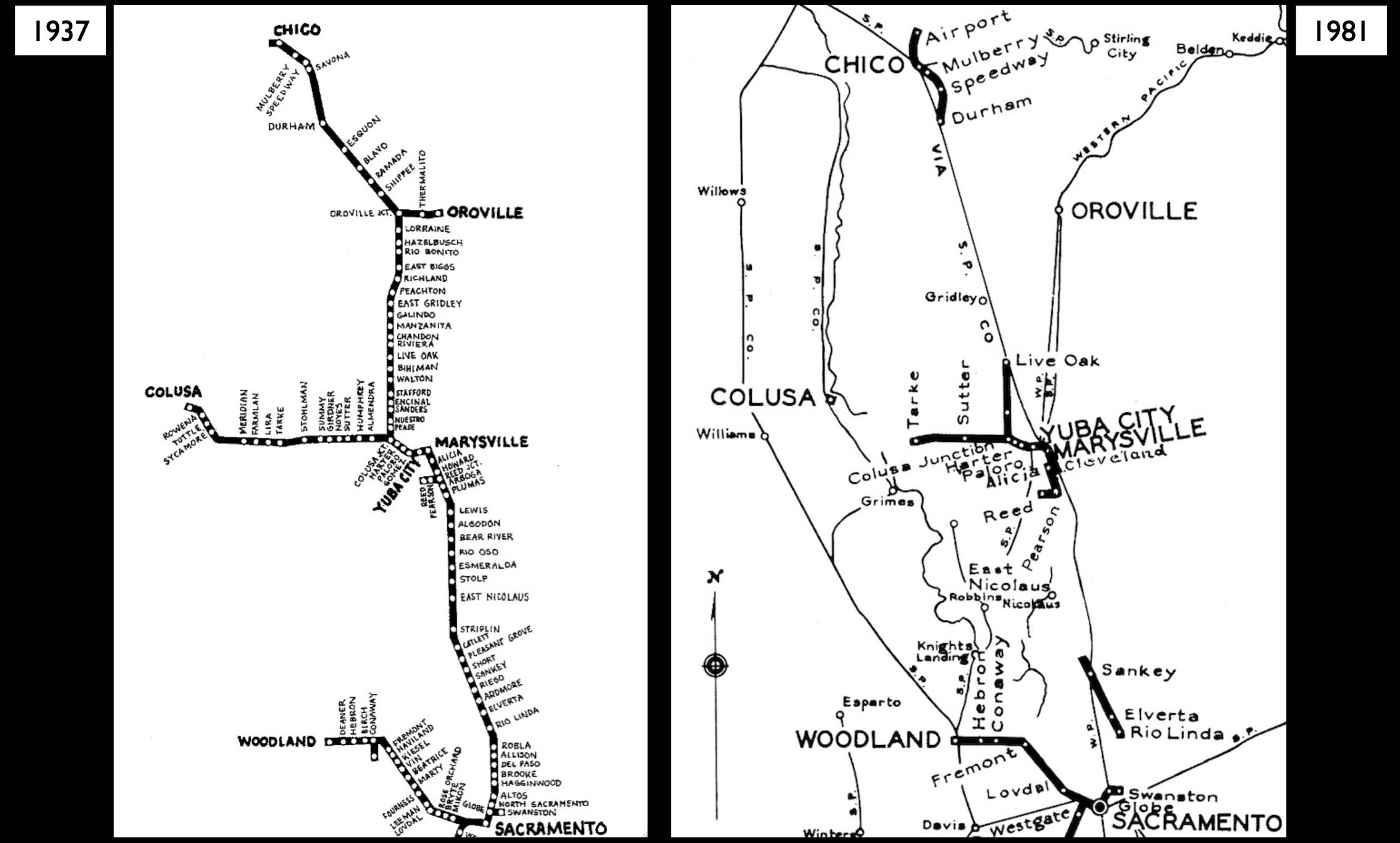
Despite the proposal to rearrange the SN route south of Maryville in 1928, the SN route remained intact into Dec. 1937 as the map on the left depicts. On the right, from 1937 until one year prior to the WP’s merger with the Union Pacific, UP, in 1981, the system would be reduced to isolated fragments, with extension of service to the Chico Airport being the only addition of track during this time. That subject is covered in another update.
L311-85-Wayne Hom Drawing, Courtesy John Harder, and Moreau Coll., Courtesy BAERA, WRM Archives, (Image 17 of 22)
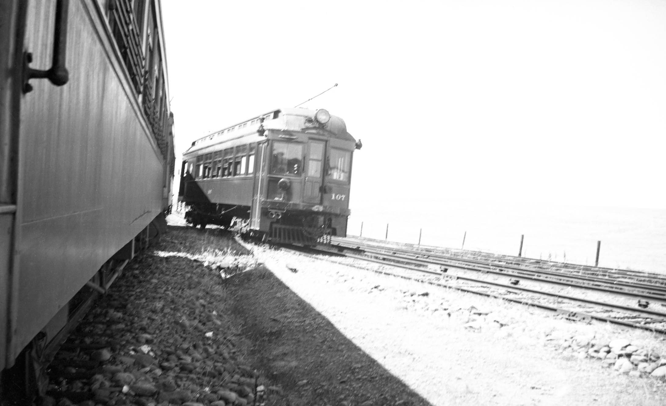
The first isolated island of service with elimination of track occurred as a result of flooding by the Feather River between Dec.10-12 1937 that destroyed the trestle connecting the truss bridge over the river to Oroville. It was decided not to repair the damage, and as a result, passenger service from Oroville Jct., shown in this pre-flood north view of SN 107 alongside a mainline train came to a close.
L311-90-Courtesy BAERA, Western Railway Museum Archives, 223974sn, (Image 18 of 22)
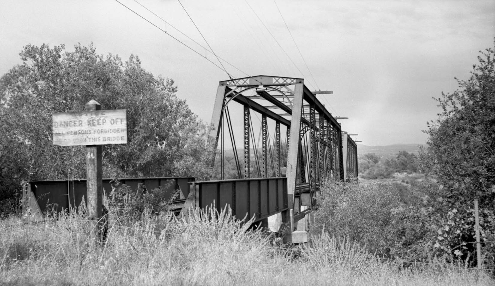
SN freight operations in Oroville operated detached from the mainline as a switching service for WP, SP and even SN customers for twenty more years. Infrequent service to Thermalito was serviced via the mainline. The track between Thermolito and the Feather River was no longer used. An east view from 1940 of the still intact abandoned truss bridge from the western bank of the Feather River is shown here. The flood impact on the Oroville Branch is covered in another update.
L311-95-Vernon Sappers Collection, Courtesy BAERA, Western Railway Museum Archives, 106924sn, (Image 19 of 22)
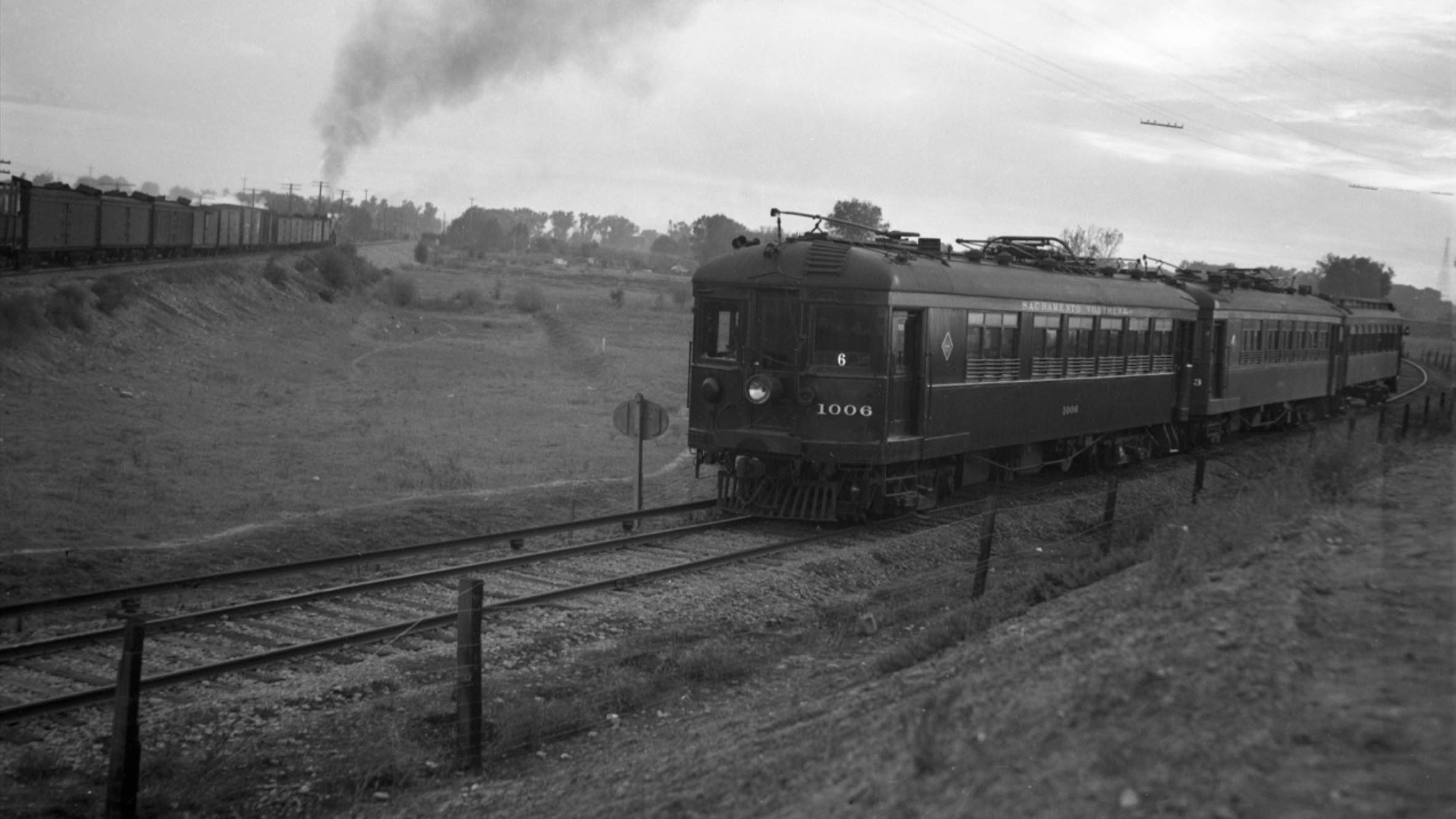
SN 1006, SN 1003 and a trailer wait for a WP freight to pass at Globe on the evening of Oct. 30, 1940, south view. This was the last passenger train to Chico from Sacramento. The North End had remained unchanged after the Oroville flood, and would remain unchanged once WWII began. Appreciate that loss of streetcar operations in Sacramento and Marysville did impact loss of mainline passenger track in those towns during and right after WWII, but those city-related changes are not a focus of these updates. But another major change was at hand.
L311-100-Paul Smith Photo, Courtesy BAERA, Western Railway Museum Archives, 138440sn, (Image 20 of 22)
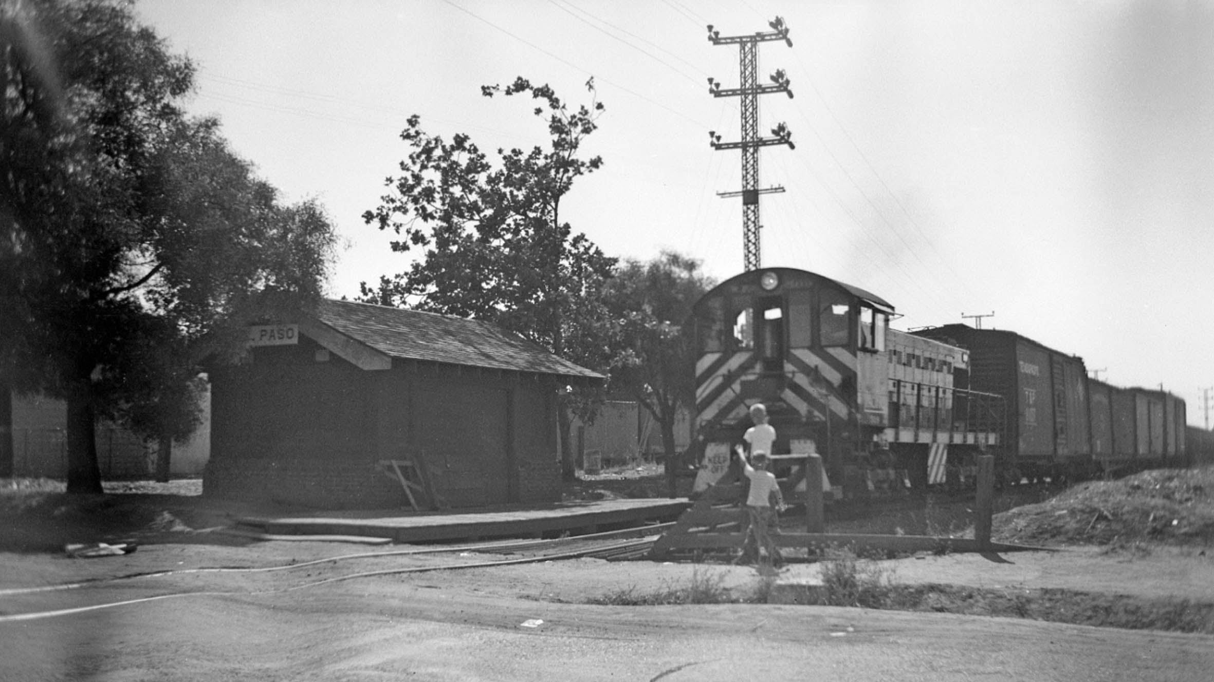
Back to image L311-05, Dave Gumz chased the WP diesel and freight to Del Paso, a south view of the station shown here minus any third rail. The financially strapped SN had deactivated the third rail on May 16, 1944 south of Marysville between Globe and Arboga due to safety concerns (see Jeff Asay’s “The Iron Feather” for details, pp. 428-430) and continued thedeactivation through the system through 1946. The SN received their major allotment of diesels in 1946, and possibly the images of WP 509 shown in this update represent a stopgap.
L311-105-Dave Gumz Photo, Courtesy BAERA, Western Railway Museum Archives, 103002sn, (Image 21 of 22)
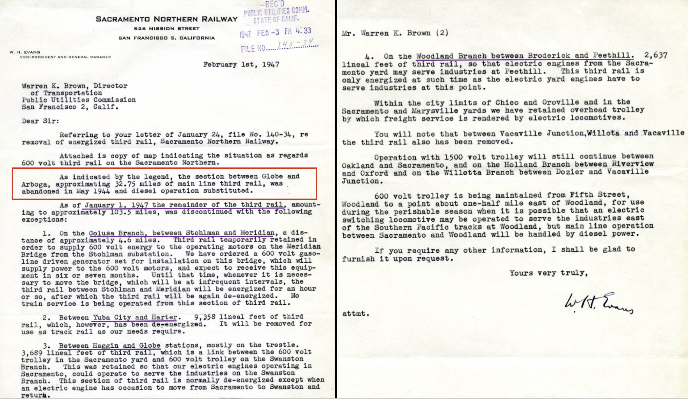
This letter from the SN’s W.H. Evans to the Public Utilities Commission in early 1947 shows that very little third rail remained, mostly needed for contingencies. The third rail on the American River trestle remained for electric motors to service the Swanston Branch, that having only used overhead wire. The Reed Branch had also only used overhead wire, and this was probably removed because electric motors could no longer get there. The real changes began in the 1950s, to be addressed next time.
L311-110-Courtesy BAERA, Western Railway Museum Archives, 41233, (Image 22 of 22)