George Russell X – The Industrialization of Emeryville South of Stanford Avenue
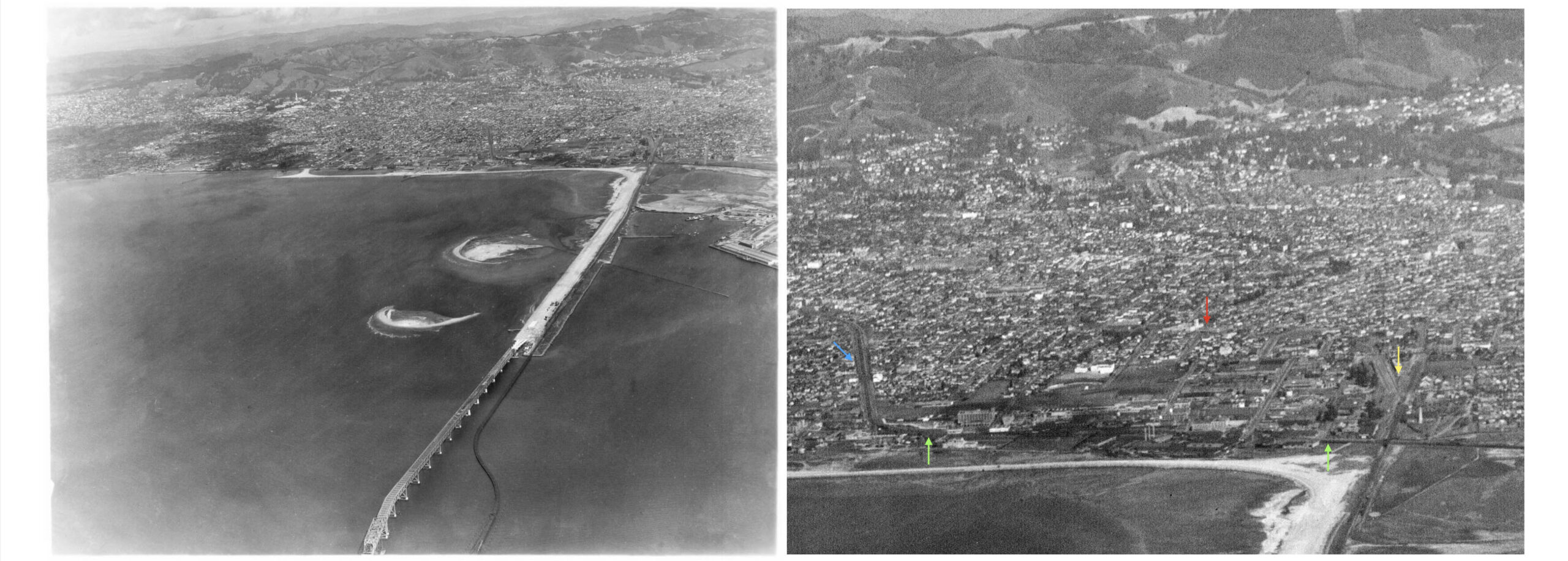
Based on his aerial photographic output, George Russell visited Emeryville on several occasions from the mid-1920s up through the construction of the Bay Bridge, left panel. For this update, the southern half of Emeryville, right panel, loosely contained within the Southern Pacific, SP, Stanford Ave. line, turquoise arrow, on the north, SP mainline, green arrows, to the west, Santa Fe and Key System yards and shops, yellow arrow, south, and Santa Fe and Key System interurban routes, red arrow, to the east, will be explored.
L277-05-George Russell Photo, Courtesy the California State Lands Commission, SLC 642_1 , (Image 1 of 33)

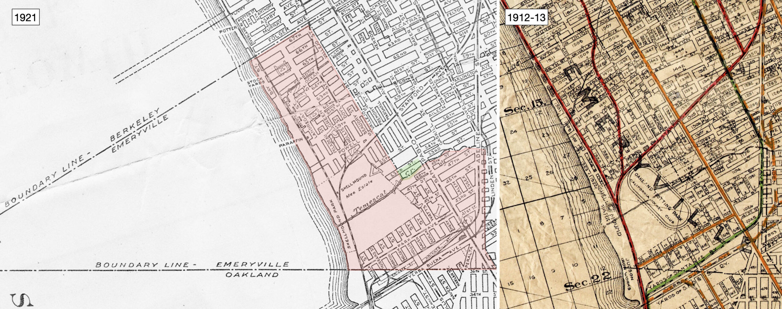
The original boundaries of incorporated Emeryville, red shading, established on Dec. 2, 1896 by a vote of 150 to 28 have been maintained in 2022 save for strategic building into the bay, and annexing land in the early 1970s from Oakland at its Temescal Creek border, green shading. Prior to the closing of the Oakland Trotting Park in 1917, and the Shell Mound Park in 1924, a large portion of southern Emeryville was dedicated to amusement, right panel. Ref: Central National Bank Map, l; Realty Bonds and Finance Co., r
L277-10-Courtesy BAERA, Western Railway Museum Archives, 83537, l, Courtesy John Bosko, r, (Image 2 of 33)
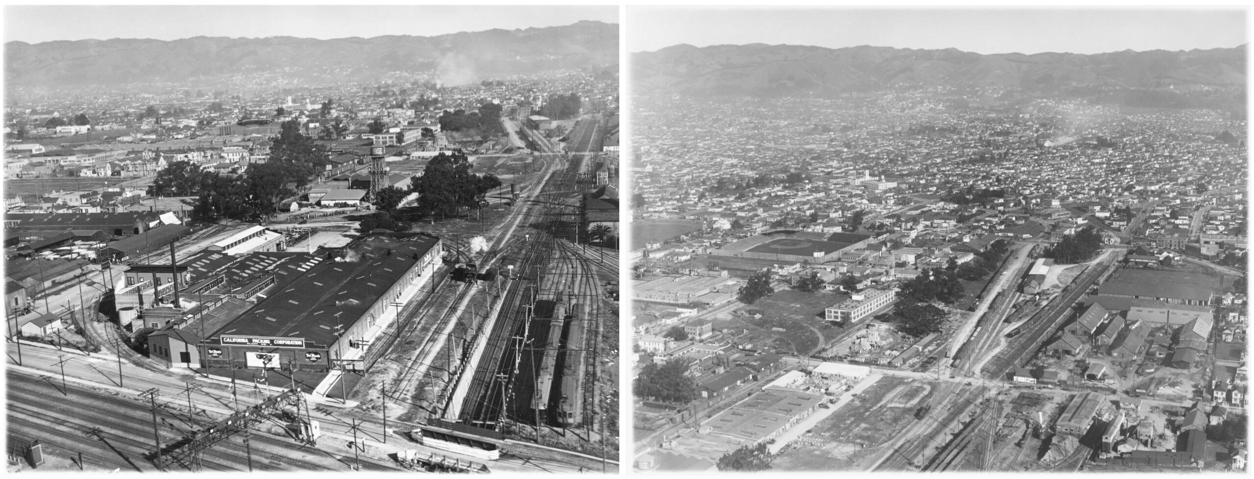
Two aerial northeast views taken ca. 1927-1928 show on the left, the California Packing Corporation, or Calpak, plant no. 7 dating to circa 1919, and totally within Oakland. The water tower of the Western Electric Co. at 40th and Hollis St. is as well, but the border cut through the building diagonally behind it. That company would move from this location to 1400 53rd St. before 1930 as will be seen shortly. The aerial on the right will be evaluated using the detail from it that follows.
L277-15-George Russell Photo, Courtesy the California State Lands Commission, SLC,651, SLC 651,74, (Image 3 of 33)
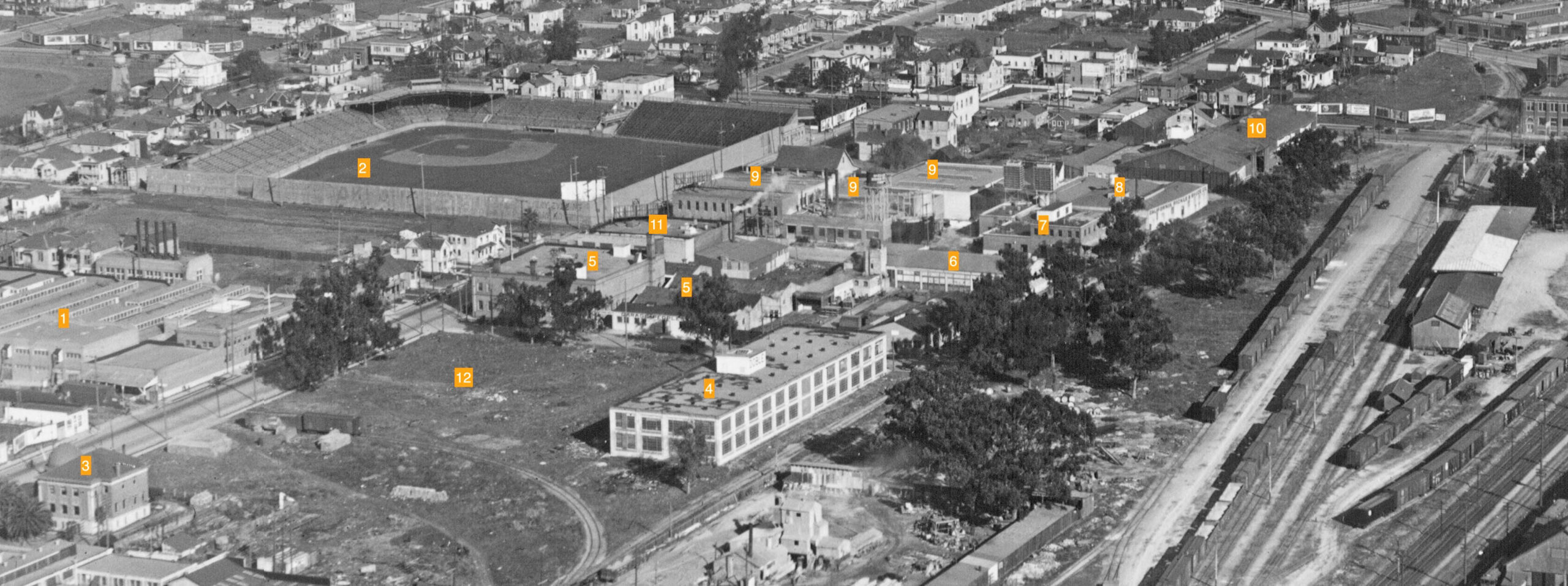
1, Calpak Plant no. 35, 1926-1989, Harlan St. and Park Ave., former Western Canning Co., 1919, Virden Packing Co., 1921; 2, Oaks Park, 1913-1955; 3, Town or City Hall; 4, Doble Steam Motors Corporation, 1928-1931, 4053 Harlan; 5, Peoples Baking Co., 1219 Park Ave.; 6, Inlaid Floor Co., 4067 Watts St.; 7, Lind Air Products Co., 40th St. and Watts; 8, California Pickle and Sauce Co., 4053 Emery St.; 9, American Rubber Co. 1145 Park; 10, William Schluter, Fuel, Feed and Mill Wood, Building Material, Gravel, Sand and Cement, 4053 San Pablo Ave.; 11, California Cracker Co., 1913, Park and Watts; The time period of this photo is approximately 1927-1928 based on Doble’s presence, and the absences of two 1929 buildings; Fisher Body, still a lot at no. 12, and the Ritz Hotel at San Pablo and Yerba Buena Ave., missing in the two previous images.
L277-20-George Russell Photo, Courtesy the California State Lands Commission, SLC 642_7, (Image 4 of 33)
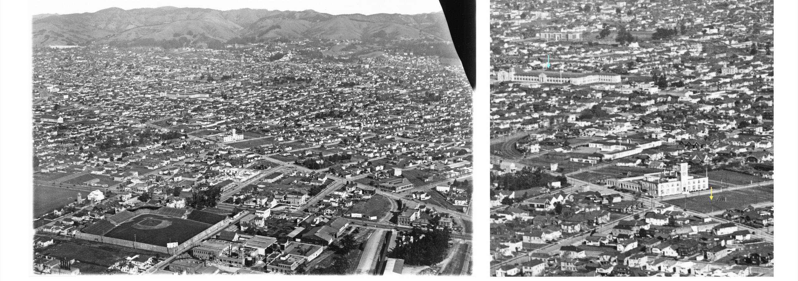
This northeast view of the eastern border of Emeryville with Oakland, left panel, was taken sometime ca. 1924-1925. The right panel is a detail showing the presence of University High School, later City or Merritt College, turquoise arrow, that opened in 1923, and south of the Remar Bakery building the absence of the Aluminum Cooking Utensil Co. building, yellow arrow, that company noted at that site in 1926. For more on the Linden St. area, refer to “Transformation of the Linden St …” on this website.
L277-25-George Russell Photo, Courtesy the California State Lands Commission, API 651 16 BOX 94, (Image 5 of 33)
Details of the previous northeast view rotated 5 degrees counterclockwise provide an opportunity to feature what the city of Emeryville’s website refers to as the “Triangle” neighborhood, the area between San Pablo Ave. and Adeline St., from 41st St. to the northeastern city boundary at Temescal Creek. This view features the southern portion of the neighborhood with the Santa Fe tracks at the apex of the triangle, the railroad’s station out of focus along the lower right edge.
L277-30-George Russell Photo, Courtesy the California State Lands Commission, API 651 16 BOX 94, (Image 6 of 33)
The northern portion of the “Triangle” is featured in this second northeast view with San Pablo Ave. continuing parallel to the lower edge or west, and Adeline St. partially in view along the top with the Remar Bakery. The trees mark Temescal Creek, culverted for good ca. 1972 from Adeline to San Pablo by the Alameda County Flood Control and Water Conservation District. According to the Sanborn map, the red arrow points to the tower of the Emeryville Dept. No. 1 fire station, while the yellow arrow to a “Room and Board”, but previously Joseph Emery’s Italianate mansion from 1868 based on a drawing and description in “Emeryville” by the Emeryville Historical Society.
L277-35-George Russell Photo, Courtesy the California State Lands Commission, API 651 16 BOX 94, (Image 7 of 33)
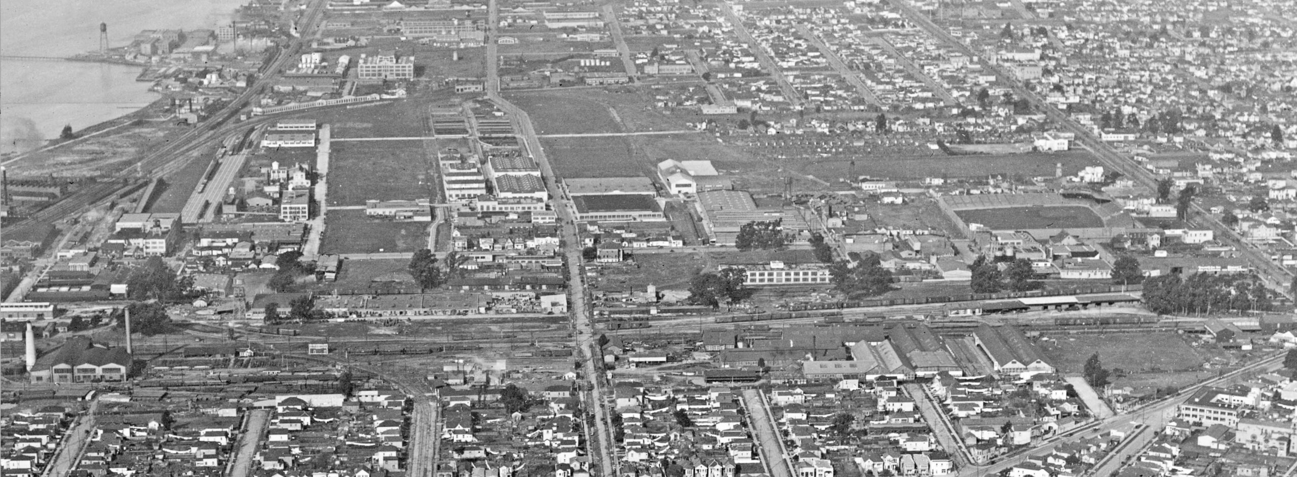
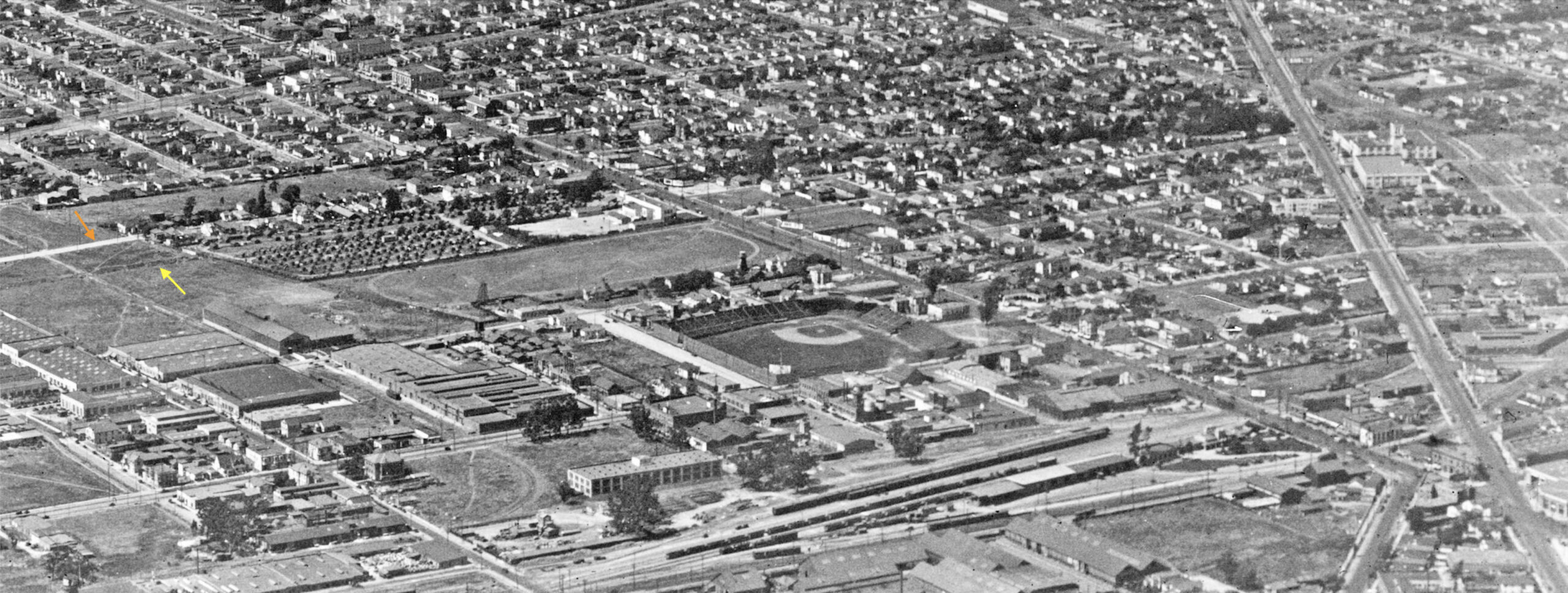
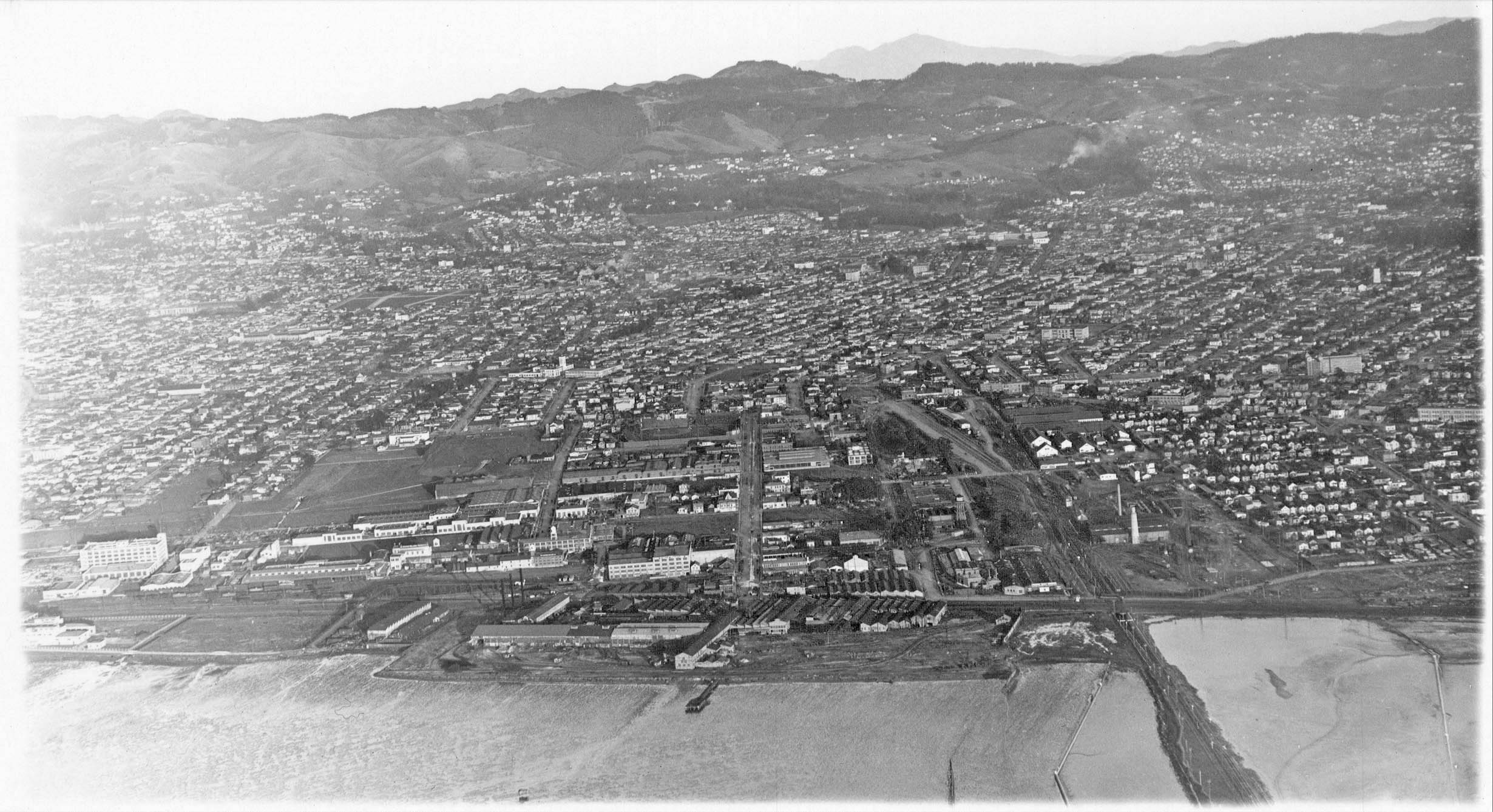
Russell’s progress will now be approached with northerly views, this one mid-1920s with the venerable Judson Manufacturing Co. steel and rolling mill along the shoreline. One of the last of steel mills on the West Coast, it survived for over 100 years until 1986. Note beyond the mill is an area with dense tree growth, corresponding to the yet completely razed Shell Mound Park. Following the mainline of the SP to the steam plume of an approaching locomotive, the former land occupied by the trotting park is still mostly empty.
L277-40-George Russell Photo, Courtesy the California State Lands Commission, SLC 642, (Image 8 of 33)
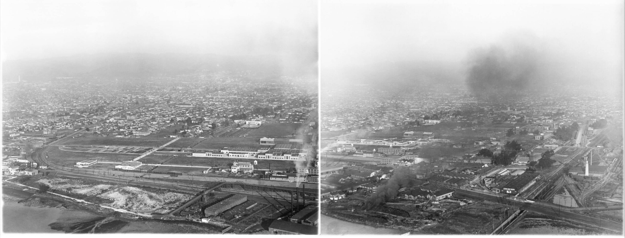
The same north view taken a few years later, but prior to 1928, and there has been a dramatic influx of buildings and SP spurs into the area. The park area beyond Judson Manufacturing Co. has been totally cleared of all trees.
L277-45-George Russell Photo, Courtesy the California State Lands Commission, API 642 9 BOX 92, (Image 9 of 33)
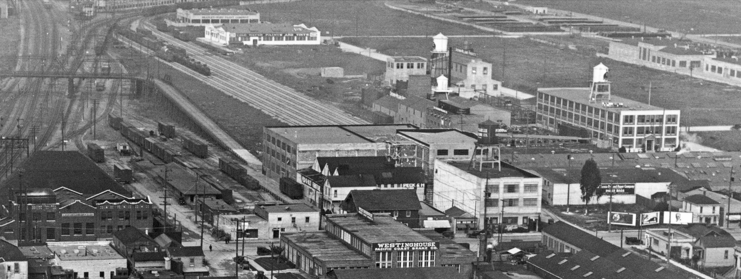
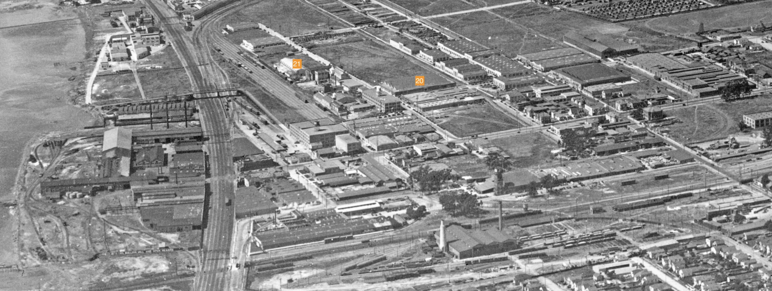
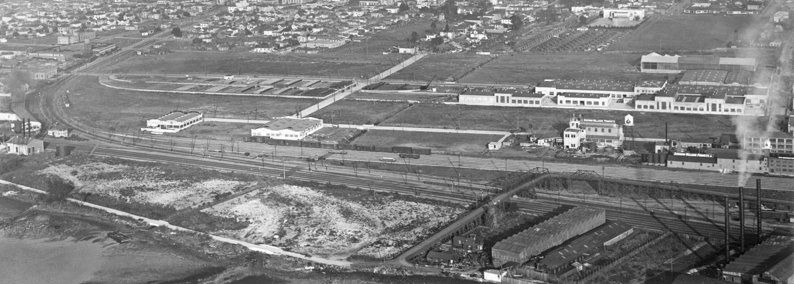
A detail from the previous north view: 13, Air Reduction Co., ca. 1917, Park Ave. and Halleck St.; 14, Peck and Hills Furniture, ca. 1907, Park and Hubbard St.; 15, California Bag and Paper Co., 4221 Horton St.; 16, Westinghouse Pacific Coast Brake Co., ca. 1912, at Park and Hallek; 17, Sherwin-Willams of California, 1919, Shellmound Ave. and Horton St. Newer buildings include 18, Cold Water Paints and Tints, and 19, Bradley-Wise Paint Co. The lot for Kirsch Manufacturing Co., no. 20 at 1420 45th and Horton, is empty, the company not listed until 1928, as is the lot for Rheem Manufacturing, no. 21, not listed until 1927.
L277-50-George Russell Photo, Courtesy the California State Lands Commission, API 642 9 BOX 92, (Image 10 of 33)
Two more north views ca. 1925-1927 to allow direct identification through signage of the buildings north of Calpak. The orange arrow on the left points to the SP Emery station shelter. Find it on the right and note the SP single red car electric train just north of it.
L277-55-George Russell Photo, Courtesy the California State Lands Commission, API 651,76,78,BOX 91, (Image 11 of 33)
A detail of the north view, left panel, L277-55, allows for many of the buildings described in L277-50 to be unequivocally identified.
L277-60-George Russell Photo, Courtesy the California State Lands Commission, API 651 76 BOX 91, (Image 12 of 33)
For completeness, a detail of the north view, right panel, L277-55, also allows for many of the buildings described in L277-50 to be unequivocally identified.
L277-65-George Russell Photo, Courtesy the California State Lands Commission, API 651 78 BOX 91, (Image 13 of 33)
The north views shown so far have all been dated during the period of 1925-1927 based primarily on telephone directories, Sanborn maps, and, when available, corporate histories. Another useful visual marker for dating purposes is the presence of the H. J. Heinz factory at Ashby Ave. and San Pablo Ave. in Berkeley. As an example, the insert in the north view on the left shows a clear field where the factory will be, while the one on the right has the distinctive smoke stack, water tower, and building shape. The May 1926 directory lists Heinz at 1st National Bank, indicating entry into the area from Pittsburgh, PA. The May 1927 one as the bank and 2860 San Pablo. Susan Cerny notes the building was built in three phases, between 1927 and 1928. See http://berkeleyheritage.com/berkeley_landmarks/heinz.html
L277-70-George Russell Photo, Courtesy the California State Lands Commission, API 651,4,8,BOX 91,92, (Image 14 of 33)
Back to more building identification, this time to the east of the Sherwin Williams complex during the 1925-1927 period. This view is a detail from the previous image in the left panel, but one with better resolution of the same area will be shown next. This image does provide a nice view down San Pablo Ave., and shows the future Emery High School building, built in 1920, white arrow.
L277-75-George Russell Photo, Courtesy the California State Lands Commission, API 651 8 BOX 92, (Image 15 of 33)
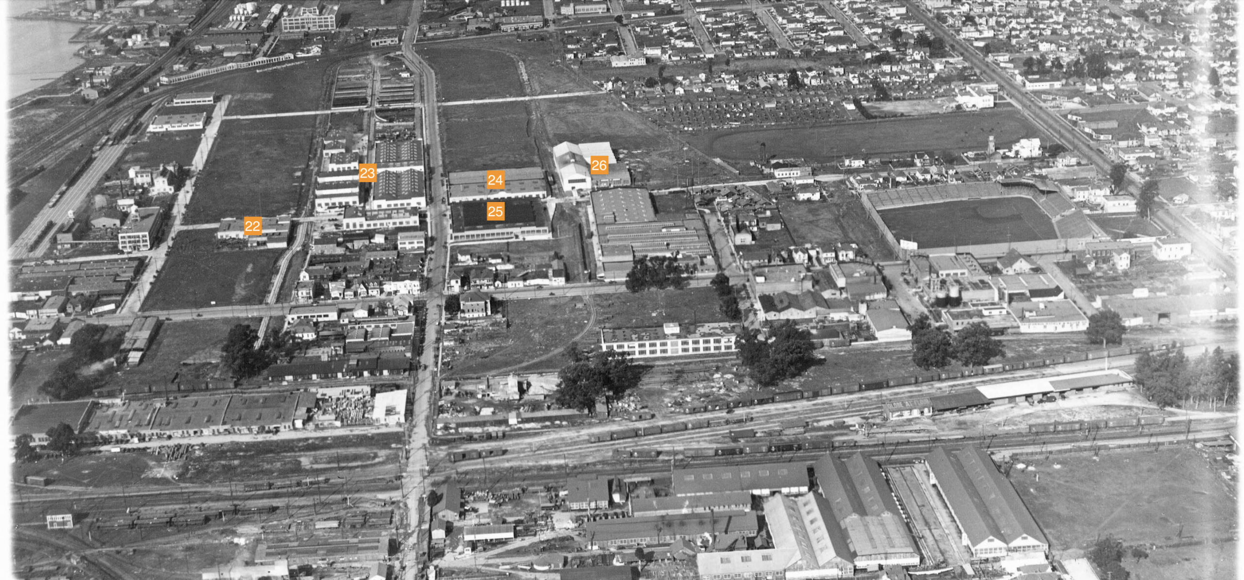
Another north view of south Emeryville from the 1925-1927 period is shown here. 22, Western Aluminum Co., 1921-1925, 45th St. and Holden St; 23, the extensive Pacific Gas and Electric operation, 24, Perfection Stove, 1280 45th St. at Hollis, oil burning stoves, heaters and Superfex Refrigerators; south side, J. R. Watkins Co., 4512 Hollis; 25, north to south, Rola, 4250 Hollis; 1927 Simmons Co., 4246 Hollis; Mc Quay Norris Manufacturing Co., auto parts, 4244 Hollis; 26, Hubbard and Co., 1250 45th St., iron works. Watkins would not share space in no. 24 until 1927 based on listings.
L277-80-George Russell Photo, Courtesy the California State Lands Commission, SLC 642_10, (Image 16 of 33)
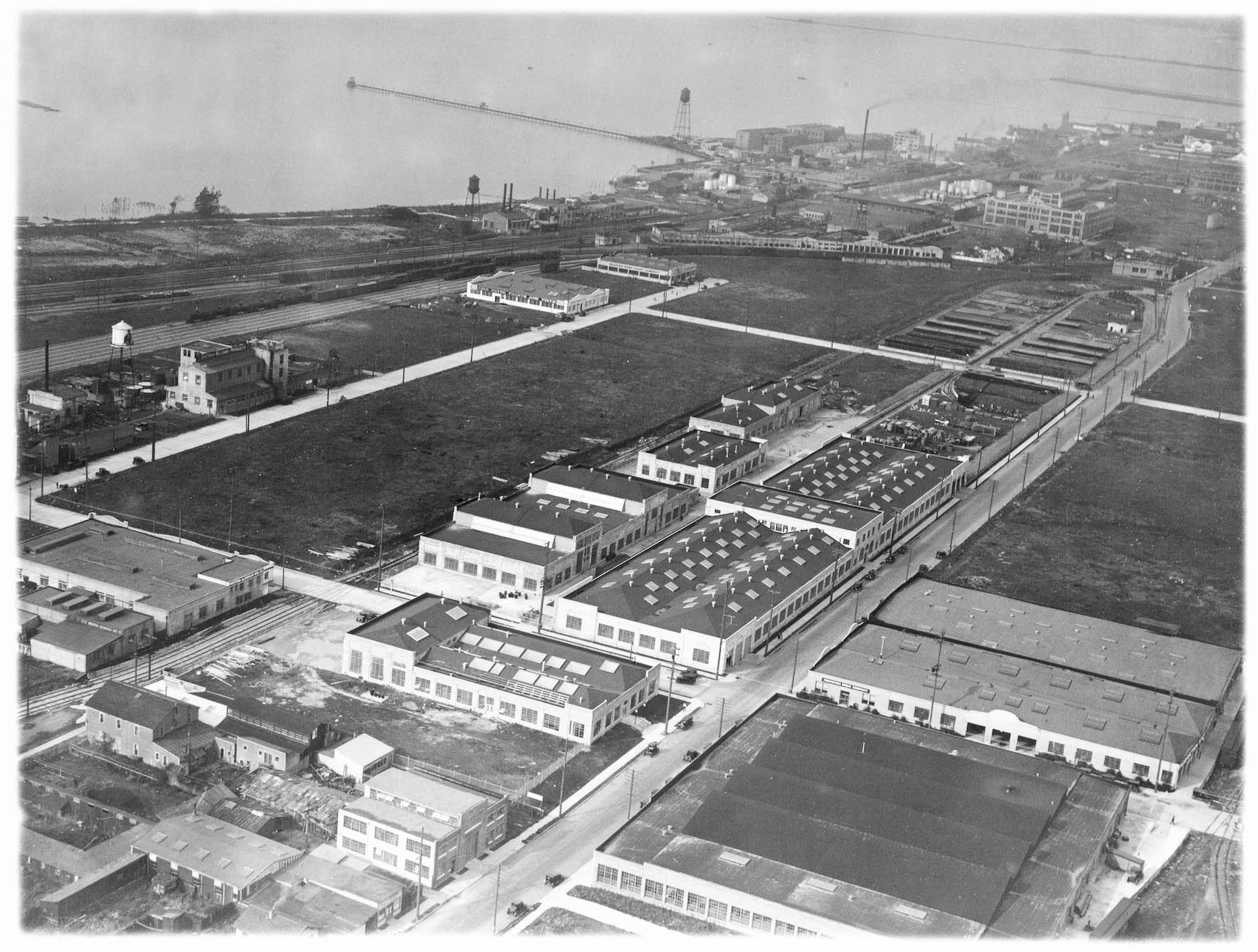
To wrap up this discussion of the 1925-1927 period, Russell brought his aircraft down to produce this northwest view of the area of interest.
L277-85-George Russell Photo, Courtesy the California State Lands Commission, SLC 642_14, (Image 17 of 33)
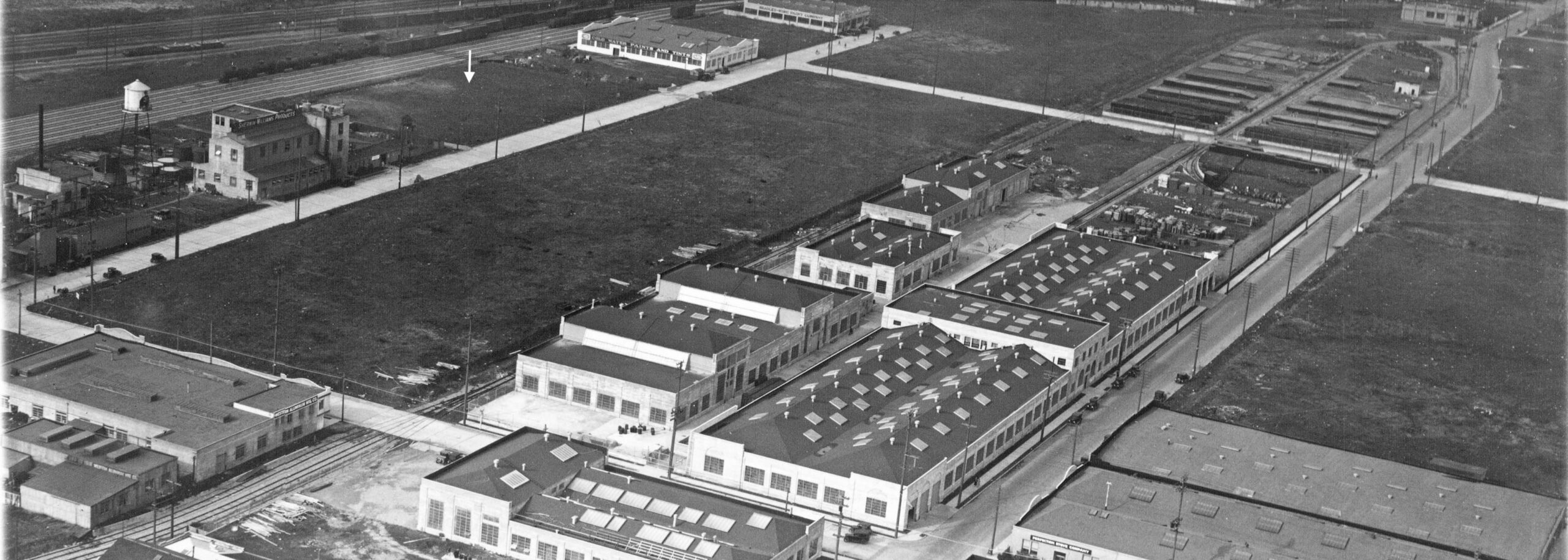
A detail of the previous northwest view includes signage for five firms already reviewed. Already mentioned, the empty lot to the north of Sherwin-Willliams, white arrow, will soon to contain a building housing Rheem Manufacturing Co., first listed in 1927. Incidentally for those with appreciation for Moraga, CA., Richard S. and Donald L. Rheem with financial help from brother William K. Rheem formed a co-partnership with the Pacific Galvanizing Company to galvanize steel drums and other metal products on June 20, 1925.
L277-90-George Russell Photo, Courtesy the California State Lands Commission, SLC 642_14, (Image 18 of 33)
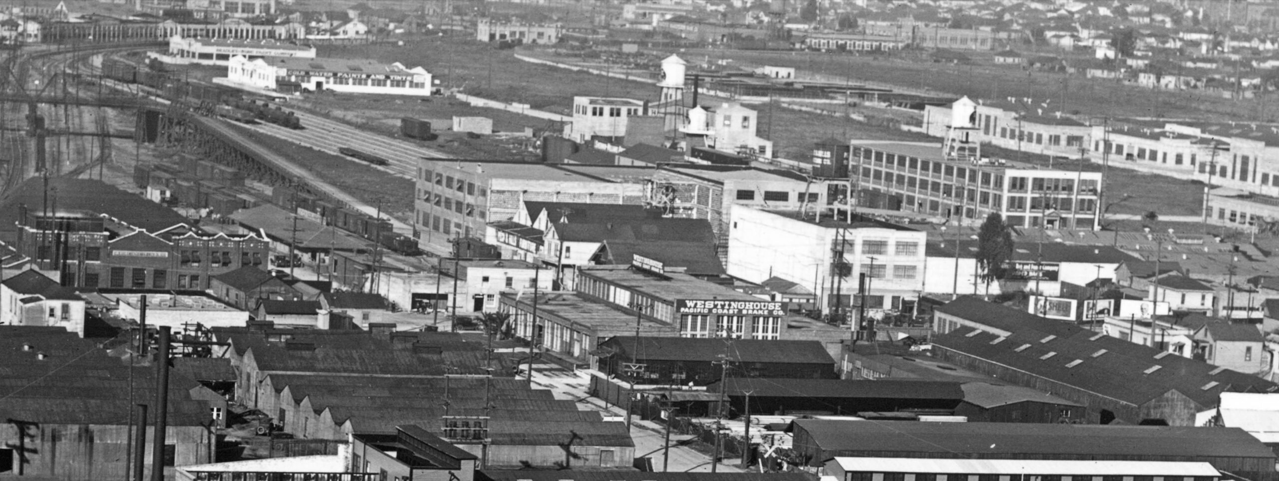
Back to the right panel in L277-70, the north view from a later date that showed the H.J. Heinz factory. Two empty lots previously mentioned are now filled; 21, the Rheem Manufacturing Co., 4535 Horton St.; 20, Kirsch Manufacturing Co., 1420 45th St. and Horton, makers of curtain rods. The orange arrow points to some construction work in progress.
L277-95-George Russell Photo, Courtesy the California State Lands Commission, API 651 4 BOX 91, (Image 19 of 33)
For completeness, this is a detail of right panel of L277-70 showing the eastern section of the border with Oakland up San Pablo Ave. past the Klinknerville Inn at 59th St. In the center is Emery High School that according to “Emeryville” by the Emeryville Historical Society was elevated in stature from a secondary school in 1928. The orange arrow points to 53rd St., the present Emeryville-Oakland border, the yellow arrow to Temescal Creek, the old border, that can be clearly seen on Emery High School property putting part of that campus in Oakland before the 1970s annexation.
L277-100-George Russell Photo, Courtesy the California State Lands Commission, API 651 4 BOX 91, (Image 20 of 33)
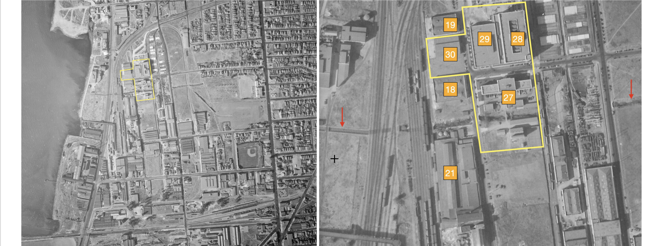
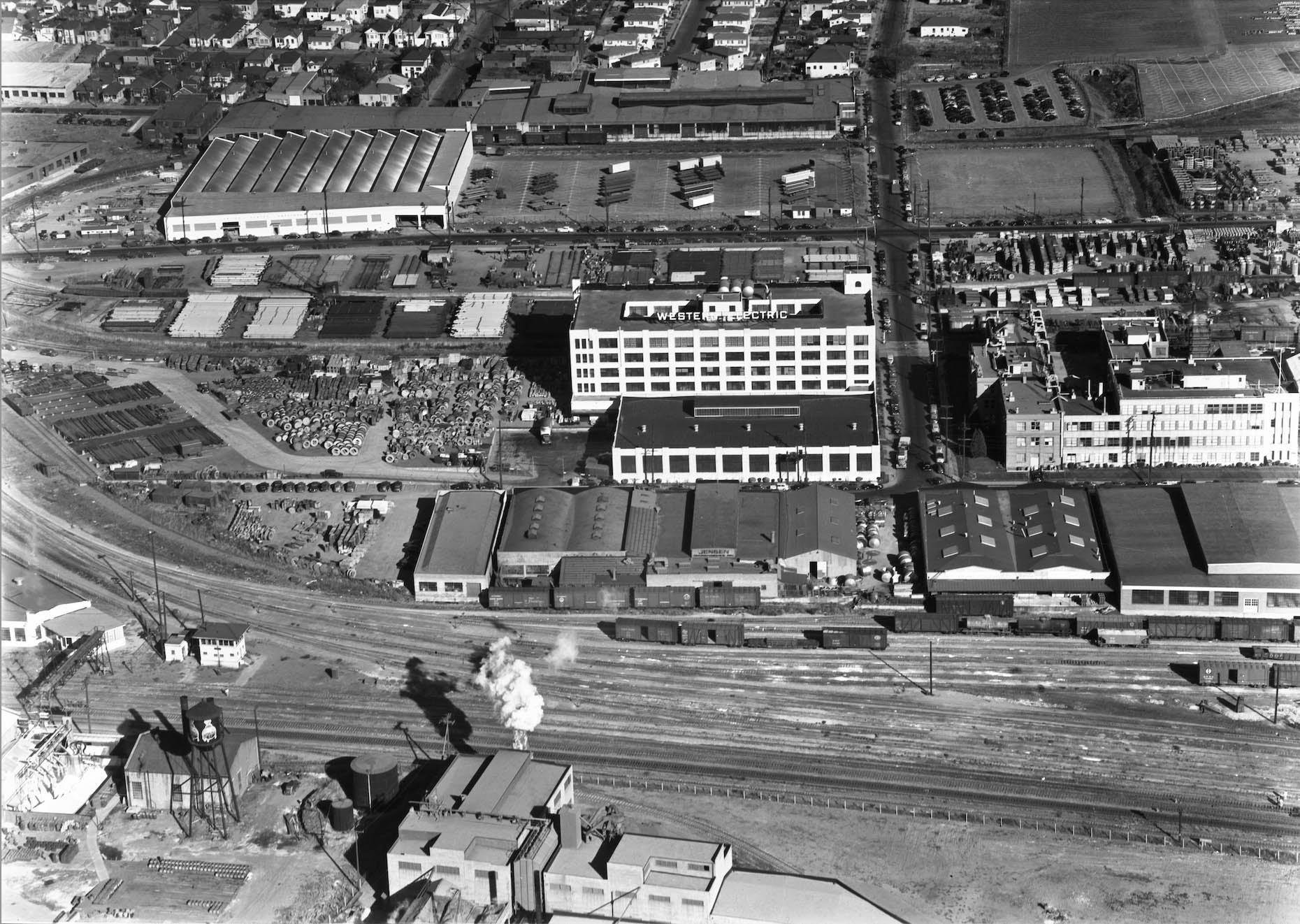
Next to approximate the date more precisely for the previous two images. The vertical aerial, left, from Oct. 31, 1931 shows further industrial development relative to the previous images, suggesting that they were taken between 1928-1930. From the detail, right, 27, Shell Development Co., 53rd St. and Horton St.; 18, E. J. Chubbuck Co., 4595 Horton, oven mfgs. sharing space with Cold Water Paints, the latter not listed in 1931; 21, Rheem; 30, American Tractor Equipment Co., 5301 Horton; 28, The Western Electric Co., 1400 53rd St.; 29, Pacific Telegraph and Telegram Co., garage; 19, Thorsen Tools, 5321 Horton, in place of Bradley-Wise Paint Co. that moved to 3257 San Pablo Ave. in 1931. The red arrows point to Temescal Creek.
L277-105-c-1820 46, Courtesy of UCSB Library Geospatial Collection10:31:1931, (Image 21 of 33)
From the beginning of this presentation, we know George Russell was in the Bay Area while the Bay Bridge was being constructed. Finally, this final north view shows the Heinz factory along the top edge, center, and the additional buildings in the previous 1931 aerial.
L277-110-George Russell Photo, Courtesy the California State Lands Commission, SLC 644_3, (Image 22 of 33)
Aerials viewed to the south or west were not found among George Russell’s holdings, but a few more east views such as this one with the buildings from 1931 were represented.
L277-115-George Russell Photo, Courtesy the California State Lands Commission, SLC 642, (Image 23 of 33)
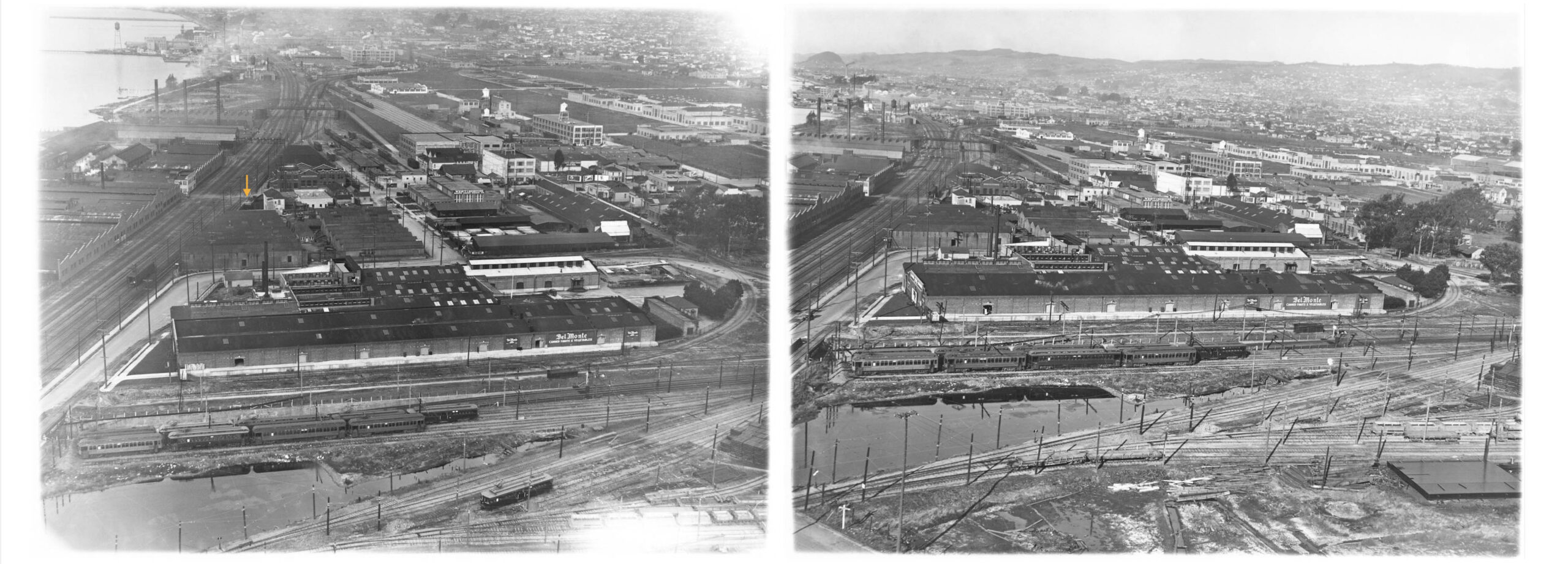
Placed side-by-side, these two east views from the ca. 1925-1927 period capture the whole portion of Emeryville reviewed in this update, from the Key yards on the south, right, to just past the SP Stanford Ave. trackage, left. The images also bear witness to the impact of the Judson operation on air quality. Ref: SLC_642_5, l, API 642_2_BOX 92, r
L277-120-George Russell Photo, Courtesy the California State Lands Commission, (Image 24 of 33)
Presented here is a detail from the previous left panel showing the state of Temescal Creek in the mid-1920s from San Pablo Ave., top, to the bay, bottom. According to maps provided by the Alameda County Flood Control and Water Conservation District, San Pablo Ave. to Hollis St. was culverted ca. 1969, Hollis St. to the S.P. mainline ca. 1975, and the tracks to the Eastshore Freeway ca. 1965. Note too that there is no evidence of any shell mound or its park’s namesake.
L277-125-George Russell Photo, Courtesy the California State Lands Commission, API 642 2 BOX 92, (Image 25 of 33)
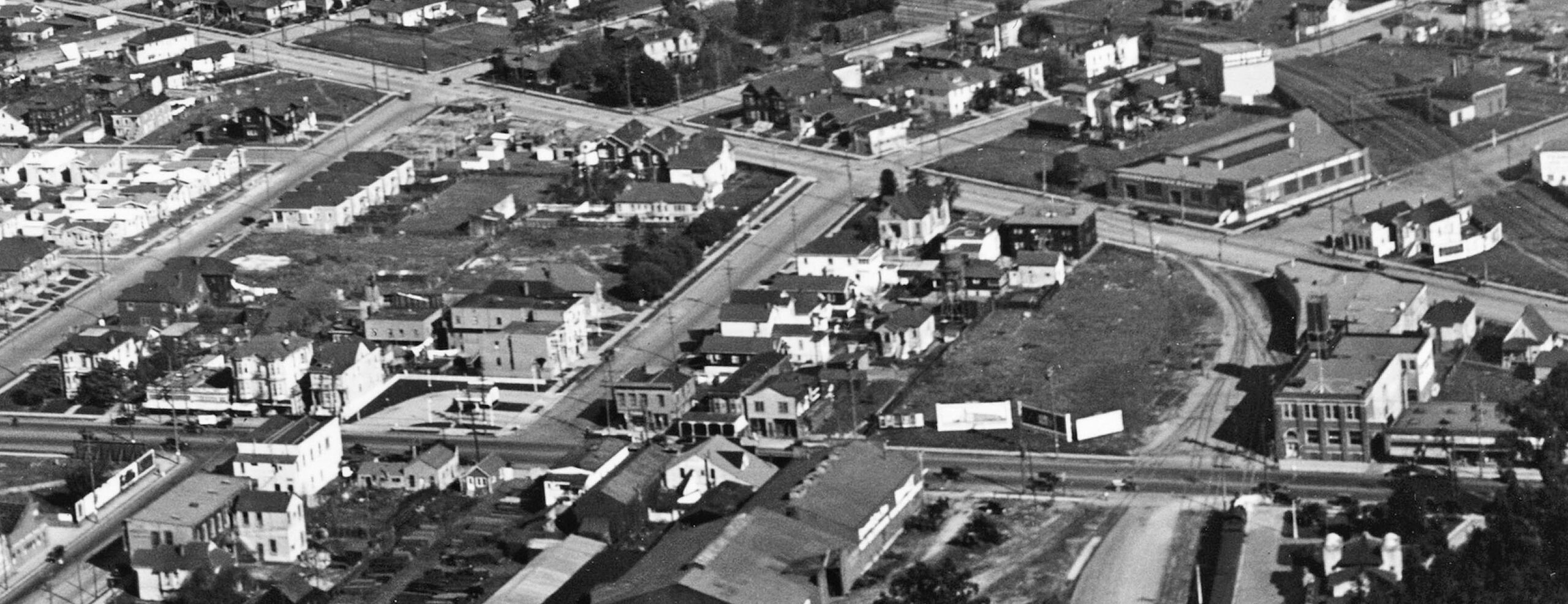
George Russell’s aerials did not highlight the San Pablo Ave.-Adeline St. crossing and border at 36th St. Here are two southeast views from May 8, 1953, down San Pablo Ave. on the left, and MacArthur Blvd. on the right. Details to follow. The complimentary north view can be found at either “Transformation of the Linden St …” entry on this website.
L277-130-Copyright California Department of Transportation, 3300-4, l, 3300-7, r, (Image 26 of 33)
The Emeryville-Oakland border from its inception in 1896 was set at 150 feet east of Adeline St. and San Pablo Ave, the latter south of the roads’ crossing. East to west the border straddled 36th St., the California Hotel in this image being an excellent marker for 35th St. Note the Key “Unit” between the Bank of America and the Ritz Hotel, and to the south or right the Reid Bros. bank of many names at Adeline and San Pablo, stripped of its Beaux Arts ornamentation. Across Adeline with the marquee, A.L. Learner’s trucks and garage at 3800 San Pablo.
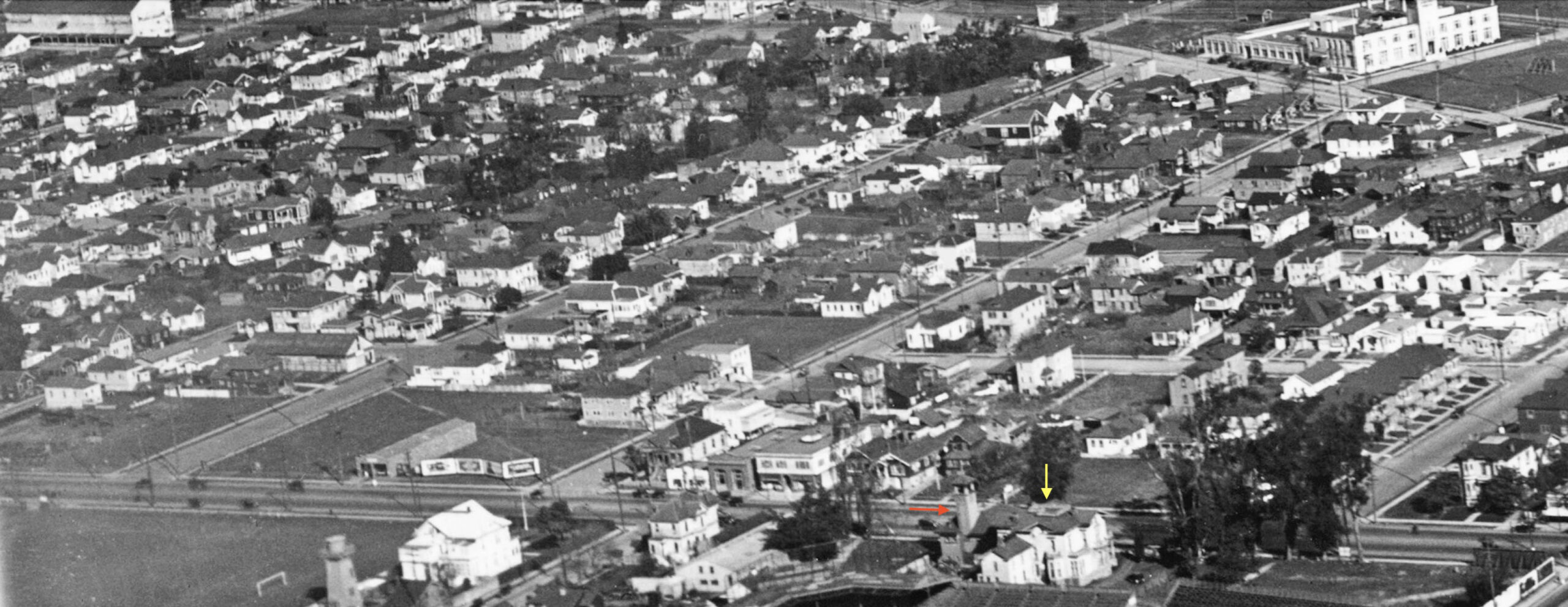
L277-135-Copyright California Department of Transportation, 3300-7, (Image 27 of 33)
The second detail features Stanley Products “Serving the West” south of the Santa Fe along the bottom or north border, the Key Tower 3, the Ritz Hotel and so much more concerning the railroads.
L277-140-Copyright California Department of Transportation, 3300-4, (Image 28 of 33)
This update has avoided discussion of the Key and Santa Fe operations as they have been covered in part at other website entries. But for model railroaders, it would be negligent not to include this detail of the Santa Fe depot and station area.
L277-145-Copyright California Department of Transportation, 3300-4, (Image 29 of 33)
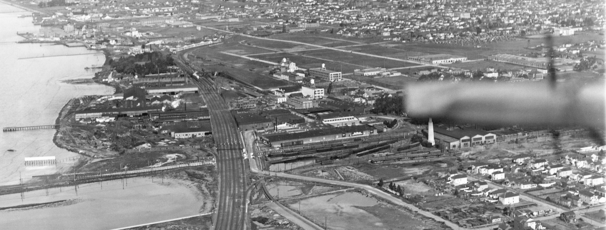
Next, a north view, left, and an east view, right, from Nov. 16, 1954.
L277-150-Copyright California Department of Transportation, 4073-9, r 4073-6, l, (Image 30 of 33)
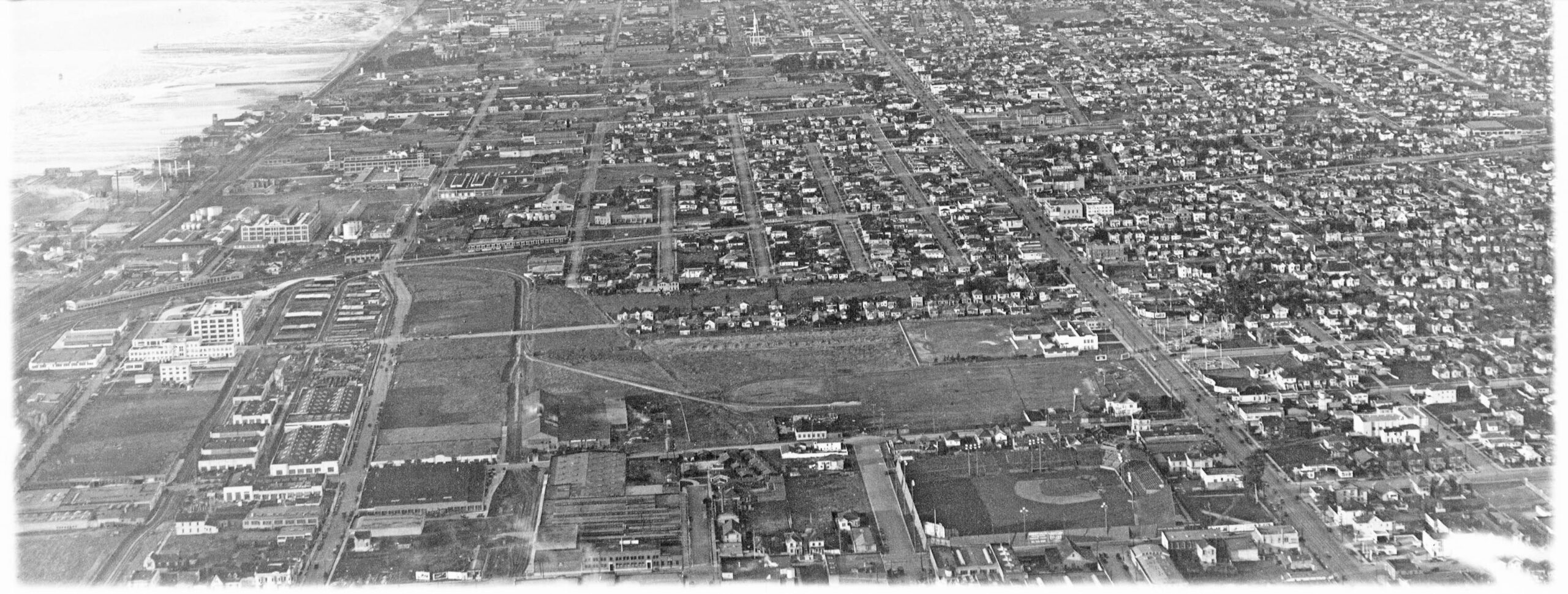
A detail from the previous east view from Nov. 16, 1954 shows the southern portion summarized in this update. The image reveals the investment in the automobile over the train, and the zenith of industrial development in Emeryville. By the end of the decade, the last passenger trains to ever traverse Emeryville will be a memory, and the city would soon take advantage of the highway by replacing the Key portion with big name retail businesses and parking lots for the cars.
L277-155-Copyright California Department of Transportation, 4073-9, Detail , (Image 31 of 33)
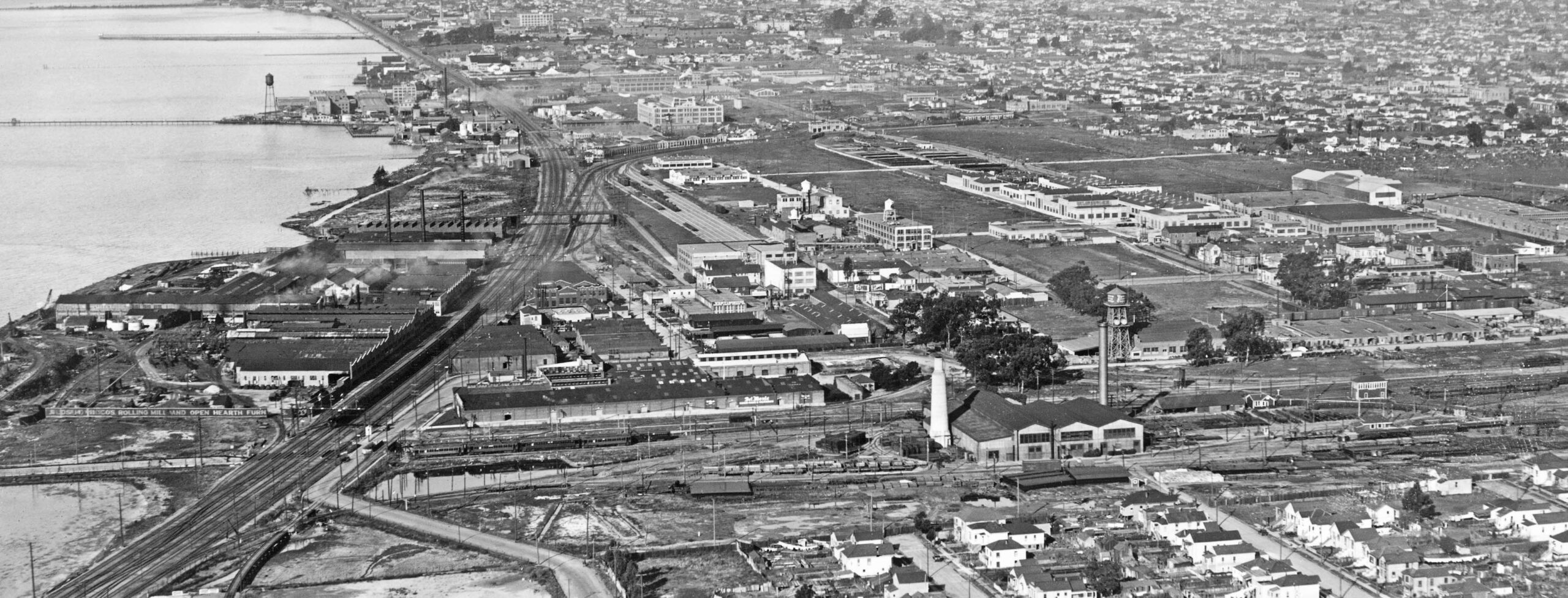
This detail of the north view from Nov. 16, 1954 provides evidence for longevity of the the buildings and some of the businesses that George Russell photographed from the air a quarter century earlier.
L277-160-Copyright California Department of Transportation, 4073-6, Detail , (Image 32 of 33)
Ending with an east view of the the Western Electric plant, with Shellmound Tower at the bottom left, from Sept. 1, 1946. In addition to the many on-line telephone directories and the ground-level images in “Emeryville” by the Emeryville Historical Society, an indispensable resource was a 1930s updated set of Sanborn maps from the Oakland History Room at the Oakland Public Library. Next time, George Russell will start here for views north of Stanford Ave.
L277-165-Vernon Sappers Collection, Courtesy BAERA, Western Railway Museum Archives, 66792, (Image 33 of 33)