Part 6 – Breaking the Bottleneck and Imminent Departure at the Bypass
The period between 1954 and 1956 ushered in the construction of Highway 24 in Contra Costa County, the original Tunnel Rd. known as Contra Costa Route 75, and with it the use of eminent domain to claim land for the new highway.
L254-05-Multiple Acknowledgements, (Image 1 of 46)

The California Dept. of Public Works, Division of Highways, from hereon in to be referred to as the State, would be creating a four-lane road on a six-lane right-of-way for the Lafayette bypass, left, and the interchange south of the bypass involving yet to be constructed El Nido Ranch Rd. would prove to be the limiting element to complete the project, right.
L254-10-Courtesy Lafayette Historical Society Archives, (Image 2 of 46)
In Orinda, the new highway would obliterate the former Tunnel Rd., and the buildings housing businesses on the north side of the road, right. What survived by Nov. 14, 1956 on the south side is shown in detail, right.
L254-15-Copyright California Department of Transportation, 5208-3 , (Image 3 of 46)
South and north views of the former Crossroads are shown here from Nov. 14, 1956.
L254-20-Copyright California Department of Transportation, 5208-1, left, 5208-2, (Image 4 of 46)
An east view north of Orinda, with the future El Nido Ranch Rd. overpass highlighted by yellow, from Nov. 14, 1956 is shown on the left. The detail on the right from the yellow boxed area is highlighted by a turquoise arrow marking the entry to the Lafayette pumping and filter plants of the East Bay Municipal Utility District, EBMUD.
L254-25-Copyright California Department of Transportation, 5208-4 , (Image 5 of 46)
Closer looks from Nov. 14, 1956 at the future El Nido Ranch Rd. overpass and the temporary Mt. Diablo Blvd. detour as diagramed in L254-10 are shown here. The yellow arrow marks the west end where Mt. Diablo Blvd. and the bypass would diverge from one another. The broken red line follows a culverted creek. This was the last part of the Orinda-Lafayette section to be finished, the year of completion, 1959.
L254-30-Copyright California Department of Transportation, 5208-5, left, 5208-6, (Image 6 of 46)
To start, shown here are summaries from the eminent domain review taken between 1954 and 1959 by the State beginning with the community surrounding Upper Happy Valley Rd.
L254-35-Copyright California Department of Transportation, Folder 6147, (Image 7 of 46)
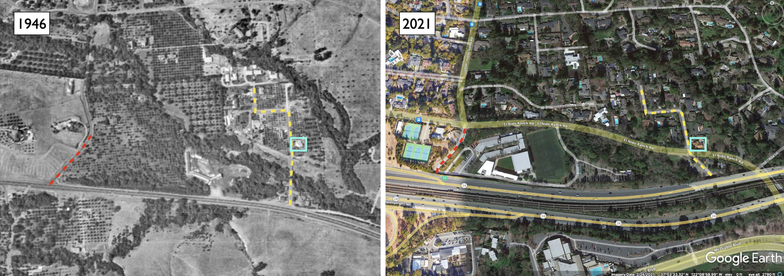
In 1946, left, Upper Happy Valley Rd., red broken line, and Sunnybrook Rd., yellow broken line, headed north directly from Mt. Diablo Blvd., and there was no El Nido Ranch Rd.. To line up the aerial from 2021, no. 996 Sunnybrook Rd., built in 1938, is contained within the turquoise box in each aerial.
L254-40-Courtesy U.C. Santa Barbara Library, Special Research Collections, Detail, and Google Earth , (Image 8 of 46)
A map of the area from 1954 is shown on the left, and the right panel is the contents of the black boxed area on the left, the parcels to be taken in part by the construction. The inserted image is a 3-year old unnumbered house that would be removed from Paulson Ct. On the right, the red line will become El Nido Ranch Rd., and the blue line is the former location of Mt. Diablo Blvd. The letters refer to what follows …
L254-45-Copyright California Department of Transportation, Folders 6163 and 6147, (Image 9 of 46)
All images from 1954. A, The Potter Wheel at 3920 Mt. Diablo Blvd., a southwest view across Mt. Diablo Blvd. of the 16 year old structure. B, Mt. Diablo Blvd., northwest corner with Sunnybrook Dr., southwest view across Mt. Diablo Blvd. of the 17 year old structure housing the tavern. C, Frontage on the south side of Mt. Diablo Blvd. opposite Sunnybrook Dr., an east view along Mt. Diablo Blvd. frontage. D, as in C, but a west view along Mt. Diablo Blvd. frontage.
L254-50-Copyright California Department of Transportation, Folders 6163, (Image 10 of 46)
Here, a panoramic from the south side frontage lot along of Mt. Diablo Blvd. taken west of L254-50, more of a west view, 1954. The right edge captures houses on Paulson Ct. that would be unaffected by the construction. More on this point shortly.
L254-55-Copyright California Department of Transportation, Folders 6163, (Image 11 of 46)
Southwest views from 1954 of no. 996 Sunnybrook Dr., left, and no. 992 Sunny brook Dr., right. El Nido Ranch Dr. would be constructed between the properties, with only the garage of the latter at risk, and the houses themselves not part of the State’s take.
L254-60-Copyright California Department of Transportation, Folders 6163, (Image 12 of 46)
The assessment of the circumstances surrounding the garage at no. 992 Sunnybrook Dr. are elucidated here in this 1954 appraisal document.
L254-65-Copyright California Department of Transportation, Folders 6163, (Image 13 of 46)
The left panel from Nov. 14, 1956 shows that the unnumbered house on Paulson Ct. mentioned previously was removed, although similar structures remained, left, with an insert from 2020 added for comparison. The right panel documents the garage to be removed from no. 992 Sunnybrook Dr. for the construction of the future El Nido Ranch Rd. somehow survived, at least in some form, and is present in 2020, as shown in the insert.
L254-70- Copyright California Department of Transportation, Folder 6163 and Google Maps, (Image 14 of 46)
The significant road construction in the vicinity of Upper Happy Valley Rd. was accompanied by a significant level of departures for houses not included in the State’s documents.
L254-75-Copyright California Department of Transportation, Folders 6163, (Image 15 of 46)
Images from 1955 of houses sold, address, age, if known, date of sale, and price in dollars, left to right, top to bottom: 2628 Bickerstaff St., July 24, 1954 for 37.5k; 3987 Rancho Rd., 1 year old, Nov. 17, 1954 for 25k; No no. Rancho Road, Aug. 30, 1954 for 7k; 1008 Sunnybrook Dr., 6 yrs old., Oct. 1954 for 19.95k; 1011 Sunnybrook Dr., 4 yrs old, Oct. 1, 1954 for 25k; 1014 Sunnybrook Dr., 13 yrs old, May 18, 1953 for 24k; 1016 Sunnybrook Dr. 13 yrs old, July 22, 1953 for 30.5k 1036 Sunnybrook Dr., 13 yrs. old, July 21, 1954 for 15k; No no. Sunnybrook Dr., 13 yrs. old, Aug. 10, 1953 for 27k.
L254-80-Copyright California Department of Transportation, Folder 6163 , (Image 16 of 46)
Examples of documents from the State’s report are shown here. The exact location of Bickerstaff St., no relation to Bickerstaff Rd. in 2021, has not been determined, and does not appear on the map provided in the document.
L254-85-Copyright California Department of Transportation, Folder 6163 , (Image 17 of 46)
Further east, the key properties impacting bypass construction will be reviewed. Both images from Nov. 14, 1956.
L254-90-Copyright California Department of Transportation, 5208-8, left, 5208-7, right , (Image 18 of 46)
The top map provides the complete planned Lafayette Bypass in July 1954. The lower map marks two types of properties that will be presented. Letters A-F represent land that had been acquired by EBMUD, and will correspond to images in L254-110. The property in the area of the former Burton Rd. and current Risa Rd. will follow.
L254-95-Copyright California Department of Transportation, Folder 6147, (Image 19 of 46)
The earlier land acquisition by the water district allowed for quick action of properties that would be on the borders of the bypass as indicated by these documents from the State from 1959.
L254-100-Copyright California Department of Transportation, Folder 6147, (Image 20 of 46)
A simple easement agreement between the State and EBMUD was all that was needed to provide highway construction as documented in these letters from 1959.
L254-105-Copyright California Department of Transportation, Folder 6147, (Image 21 of 46)
The six EBMUD-provided easements in 1954, east to west, are shown here. A, West of Elizabeth St., east view from Elizabeth St., access to property through the gate. B, Between Brown Ave. and 2nd St., west view of parcel with dirt road running along the center of the EBMUD right-of-way. C, Easterly of Orchard Rd., east view. D, Between Thompson Rd. and Oak Hill Rd., view not specified. E, Happy Valley Rd. and Thompson Rd., east view from Happy Valley Rd. F, Lafayette Blvd. vicinity, east view from Lafayette Blvd.
L254-110-Copyright California Department of Transportation, Folder 6147, (Image 22 of 46)
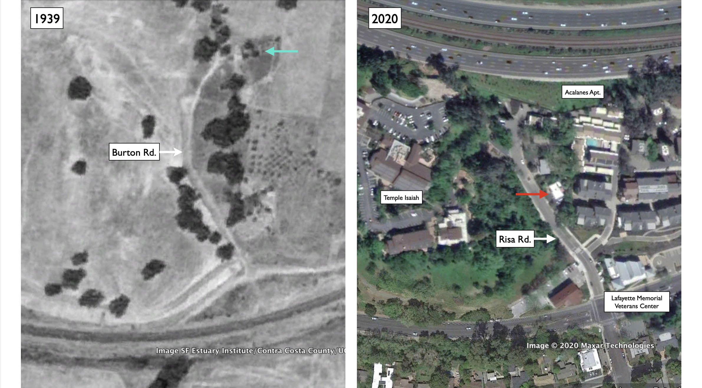
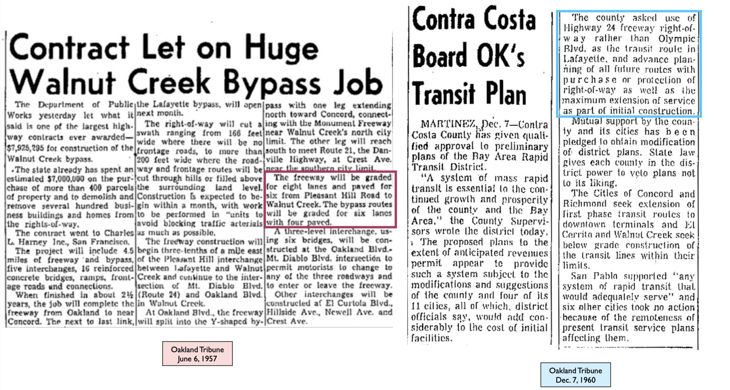
Next two images that were created by overlaying by Google Earth. The left panel shows that Burton Rd. in 1939 was undeveloped, but there is at least one property in the way of the future highway, turquoise arrow. In 2020, along what is now called Risa Rd. has utilized most of the land south of Highway 24, right. The red arrow points to 946 Risa Rd., to be placed back in time shortly.
L254-115-Google Earth, Annotated, (Image 23 of 46)
This diagram of the area from 1954 has been annotated in an attempt to fit the images and documents that follow into context. What the State called “North End of Risa Rd.” is a slice of land marked by the red arrow, and agrees with the location of the description, right. The inserted image is the the one that accompanied this property, only no direction was given, but based on what follows, it is a west view of no. 960 Burton Rd.
L254-120-Copyright California Department of Transportation, Folder 6147, (Image 24 of 46)
These two images from 1954 accompanied no. 960 Burton Rd., the image on the left said to be the rear of the residence, corresponding to the image in the insert in L254-120. The arrow marks the same residence in the right panel, white arrow, a northeast view showing Burton Rd., and the side of the home facing the road considered the front of the residence.
L254-125-Copyright California Department of Transportation, Folder 6147, (Image 25 of 46)
Based on these documents, this lot was to be eliminated by the highway, although the description and the diagram in L254-120 shows that only the northerly part of the lot was needed. Of importance is that although Burton Rd. provided access to and from Mt. Diablo Blvd. in 1954, this information was not recorded when the house was built in 1950. The house to the south or right will be presented shortly.
L254-130-Copyright California Department of Transportation, Folder 6147, (Image 26 of 46)
These two images are of no. 974 Burton Rd. The left image was said to be taken from Burton Rd., while the right one from the property that included “North End of Risa Rd.”, therefore a north view.
L254-135-Copyright California Department of Transportation, Folder 6147, (Image 27 of 46)
This property would also be taken for the highway, but only a portion was needed; here, the loss of the access to it was the deciding factor in this decision. It would appear that this would represent the property marked by the turquoise arrow in the image from 1939 in L254-115.
L254-140-Copyright California Department of Transportation, Folder 6147, (Image 28 of 46)
This image of no. 946 Risa Rd. was included in the eminent domain document of this area, because the property had been sold in 1952, thus providing a relative value of the property in the area. The home remains in the same spot in 2021 as shown in L254-115, although its garage and entrance way have since been shifted.
L254-145-Copyright California Department of Transportation, Folder 6147, (Image 29 of 46)
Returning to this northwest image from 1954, this image was also used to identify the house to the right of no. 960 Burton Rd., one that was listed for sale, but not to be taken by eminent domain for the highway. Interestingly, no house number was assigned here, and the structure as it appears here does not exist at this spot in 2021.
L254-150-Copyright California Department of Transportation, Folder 6147, (Image 30 of 46)
This post construction aerial east from Nov. 14, 1956 shows the unnumbered house to the left or north, an intervening house, now no. 950 Risa Rd., and 946 Risa Rd. to the right. The color insert if the latter two houses in 2021. The unnumbered house appeared to have succumbed in 1980 or after based on historic aerials.com. The 1956 aerial does show that more land was taken than needed for the highway, possibly to allow construction, and subsequently, a new development was added.
L254-155-Copyright California Department of Transportation, 5208-7 and Google Maps, (Image 31 of 46)
Next into central Lafayette, the left panel showing the Happy Valley Rd. Overpass, the right panel Mt. Diablo Blvd. running east until it merges with the east end of the bypass, both from Nov. 14, 1956. The turquoise arrow marks First Western Bank, in 2021 Bank of the West, just east of Lafayette Circle, while the yellow arrow points to Safeway.
L254-160-Copyright California Department of Transportation, 5208-10, left, 5208-9, right , (Image 32 of 46)
An annotated detail of the previous east view from Nov. 14, 1956 is shown. The red arrow points to the site of the future library, while the broken yellow line marks the site of the future Plaza Shopping Center.
L254-165-Copyright California Department of Transportation, 5208-9, Detail, (Image 33 of 46)
Also from Nov. 14, 1956, the image in the left panel was taken above the Oak Hill Rd. Overpass, while the right panel is an enlargement of the contents in the yellow square on the right, the intersection of Mt. Diablo Blvd. and Moraga Rd.
L254-170-Copyright California Department of Transportation, 5208-11, (Image 34 of 46)
The west view on the left was taken above the Brown Ave. Overpass of the highway, while the right panel shows the temporary connection of Mt. Diablo Blvd. with the new road. Both aerials from Nov. 14, 1956.
L254-175-Copyright California Department of Transportation, 5208-9, left, 5208-12, right , (Image 35 of 46)
The next four panels show the close-to-completed Pleasant Hill Rd. Interchange on Nov. 14, 1956, starting with these east and west views …
L254-180-Copyright California Department of Transportation, 5208-13, left, 5208-15, right , (Image 36 of 46)
… followed by these north and south views. Although Pleasant Hill Rd. north of the new highway and past Acalanes High School is a well developed road, left, the view south, right, shows no Pleasant Hill Rd. In 1956, the road present was the narrow extension of Reliez Station Rd., appreciating that Olympic Blvd. was years away from construction and was occupied by the Sacramento Northern Railway.
L254-185-Copyright California Department of Transportation, 5208-16, left, 5208-14, right , (Image 37 of 46)
Enlargements from the corresponding aerials presented above from Nov. 14, 1956 show the iconic Rick’s Drive Inn, at that time serving as a local headquarters for the State prior to the building's eventual removal.
L254-187-Copyright California Department of Transportation, 5208-16, left, 5208-14, right , (Image 38 of 46)
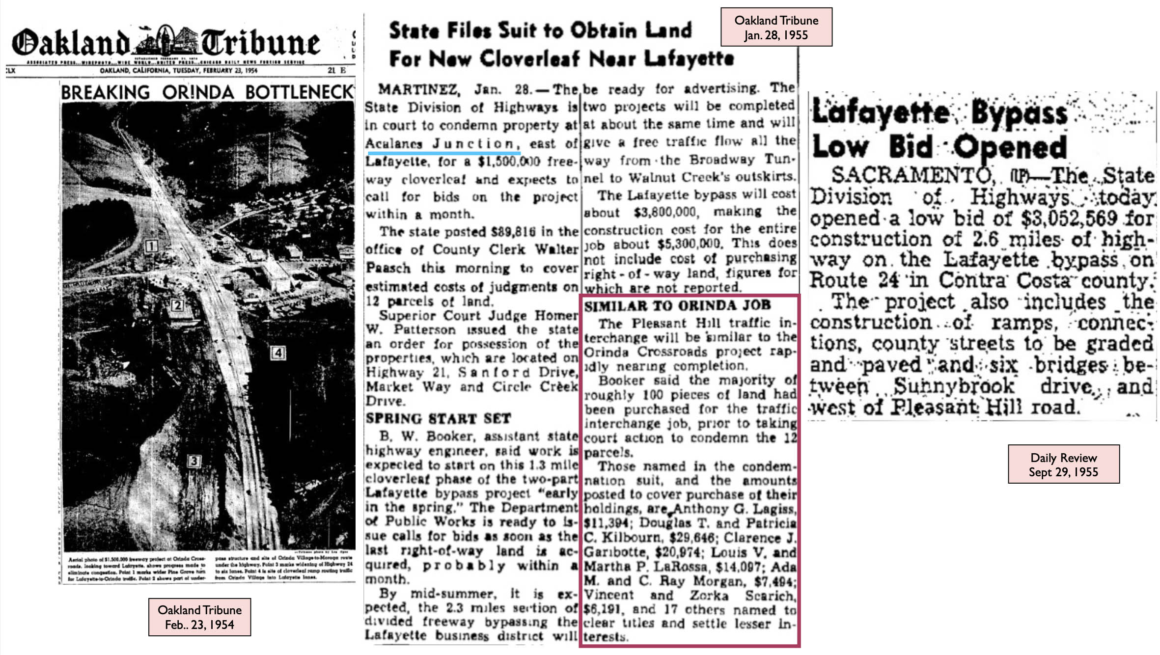
The alterations made at the Pleasant Hill Rd. intersection were started in 1951, earlier than those to the east, for reasons that will become apparent shortly.
L254-190-Copyright California Department of Transportation, Folder 6117 , (Image 39 of 46)
Properties on the southwest corner of Mt. Diablo Blvd. and what was called “Country Rd.”, hill portion 5125 and 5126 were of the most interest, southwest view, 1954. The State had only expected to use 0.167 acres of 5126, leaving 0.5 acres, but they assumed the odd triangular shape of the remaining property would render the property useless, so they acquired the whole lot.
L254-195-Copyright California Department of Transportation, Folder 6117 , (Image 40 of 46)
The owner of 5126 received 15,192.50 dollars for the land and buildings in 1954, but when the land wasn’t used for the project, he was awarded an additional 14,363 dollars by a lower court when he attempted to sue. The State, which now owned the land via eminent domain, was to sell the property for 46k dollars in 1963 pending the owners ruling against him being heard by the District Court of Appeal. The result of this ruling has not been found.
L254-200-Copyright California Department of Transportation, Folder 6117 , (Image 41 of 46)
Three properties across the north side Norton Dr. were taken, the image in the center shows an apartment house. East views for left and center images, west view for right image, all from 1954.
L254-205-Copyright California Department of Transportation, Folder 6117 , (Image 42 of 46)
Most of the properties taken in this section were empty lots, a few examples shown here from 1954. A, three lots along the north side of Sanford Rd., northeast view; B, lot 12797, on the south side of Sanford Rd., an east view toward the Acalanes Center Subdivision; C, lot 5150, on north sits of Mt. Diablo Blvd., east of Reliez Valley Rd., east view.
L254-210-Copyright California Department of Transportation, Folder 6167 , (Image 43 of 46)
This pre-BART configuration of the Pleasant Hill Rd. Interchange was complete based on the west view from Mar. 10, 1957, left. As noted earlier, once the section over Nido Ranch Rd. was completed in 1959, the highway was complete between Orinda and Lafayette.
L254-215-Copyright California Department of Transportation, 5397-5 , (Image 44 of 46)
To be complete, Highway 24 would require that the section to Walnut Creek be finished, the article on the left from 1957 outlining the initial process. Additionally, although space was left in the center of the highway anticipating a future BART line, many alterations would need to be made before a line from the hills to Walnut Creek could be completed. More on these topics later.
L254-220-Courtesy Lafayette Historical Society Archives, (Image 45 of 46)
Of greater interest is why this extensive interchange was constructed at Pleasant Hill Rd. when there were no major outlets to the south. Next time, the Saga of Highway 77.
L254-225-Copyright California Department of Transportation, 5208-14, (Image 46 of 46)