John Harder Revisits the IER Era of the Ninth St. Railway
A walk on the Peladeau Park segment of the Emeryville Greenway from Peladeau St. and Stanford Ave. to Powell St. reveals markings in the pavement, left. The previous presentation introduced the early years of the Southern Pacific, SP, Oakland, Alameda and Berkeley electric railway Ninth St. line. This presentation will deal with the last years of the electric railway, and it will be led by local photo historian John Harder as he provides a look back at the IER era versus what could be appreciated on the Emeryville-Berkeley 9th St. Greenway in 2024.
L327-05-Stuart Swiedler Photos, (Image 1 of 35)

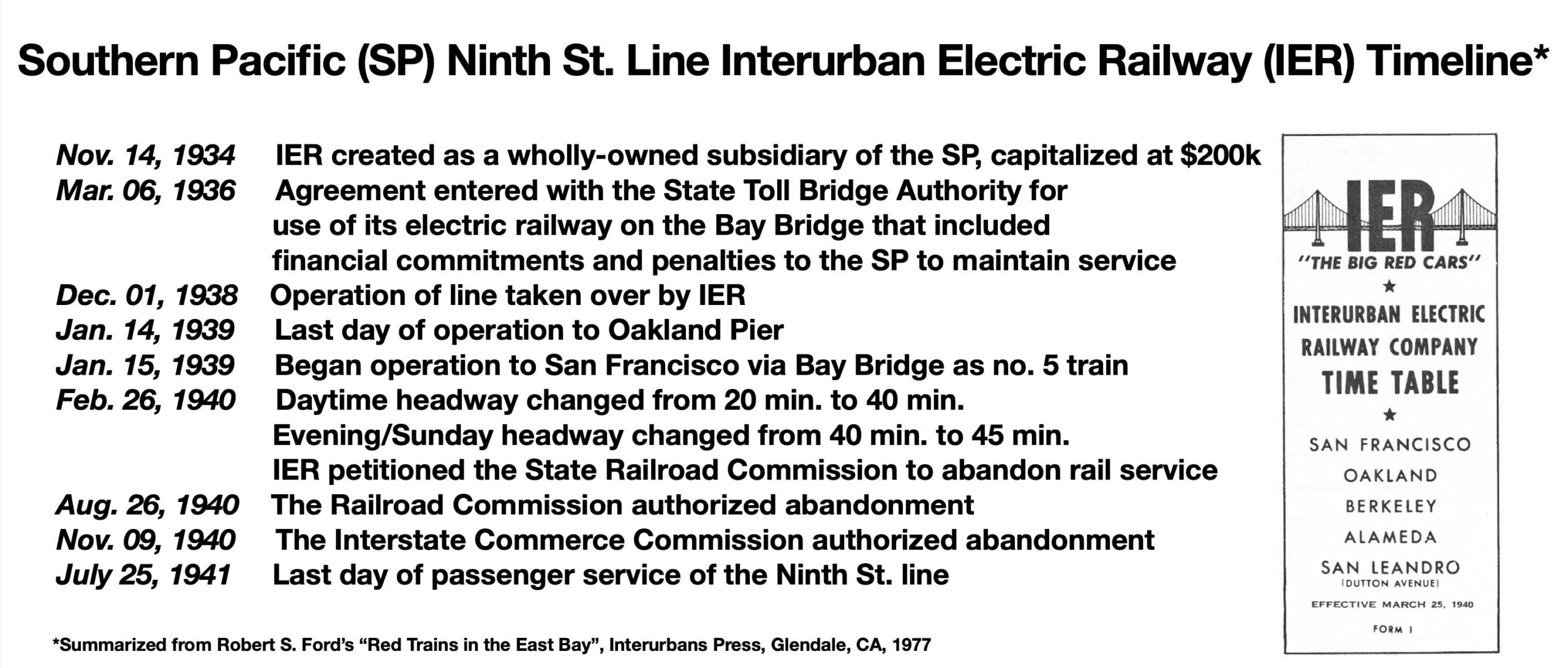
IER stands for Interurban Electric Railway, a timeline of key events presented here. Creation of the IER was the beginning of the end of the SP electric train lines to the East Bay. It allowed the SP to separate the IER expenses from its overall operating expenses. Ending the IER meant the Toll Bridge Authority would get 52 SP cars, and the right to take over the track and operations of the system. A State Railroad Commission Meeting in Dec. 1939 revealed the IER was losing $1M annually. The Toll Bridge Authority did not continue the service when it was abandoned.
L327-10-Stuart Swiedler Text, l, Courtesy BAERA, Western Railway Museum Archives, right, (Image 2 of 35)
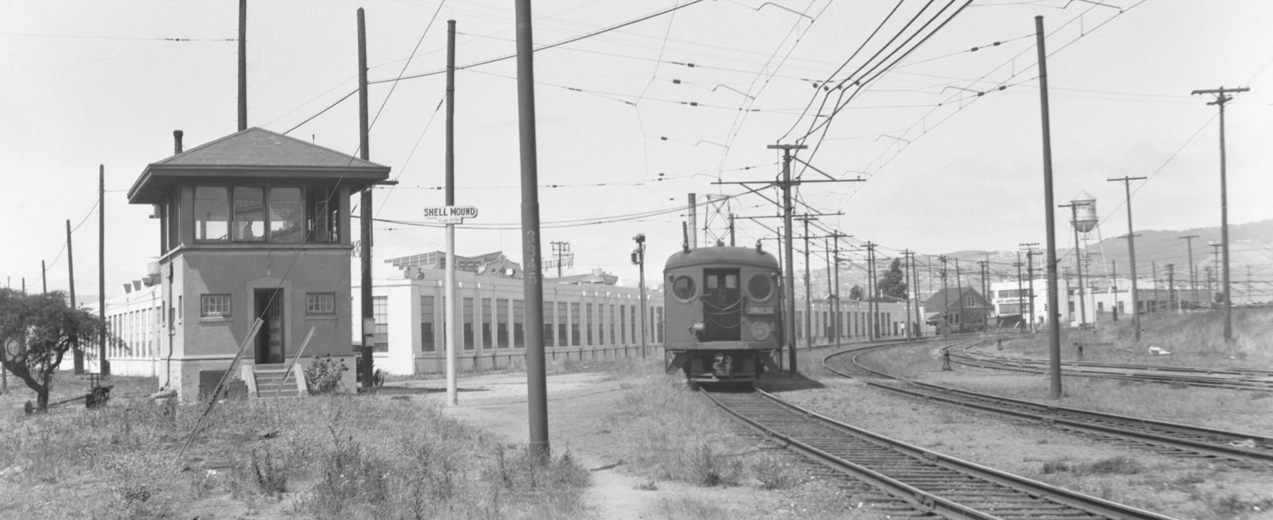
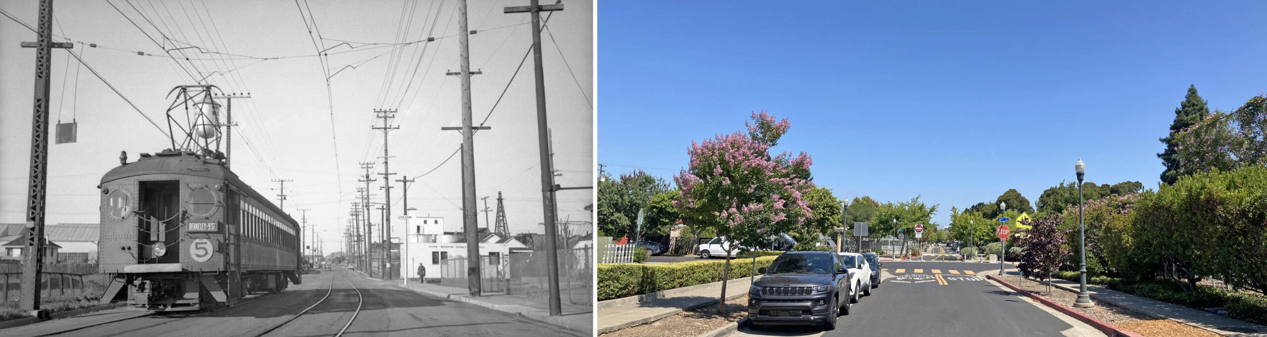
The IER designated each line with a number, the Ninth St. line being no. 5. A northeast view at the Shellmound Tower on July 13, 1941 is a reminder that all poles surrounding the tracks were numbered. The format of this update centers on comparative views. John Harder was born in Alameda in Jan. 1941, when IER service was abandoned there. Although having spent 70 plus years riding and photographing all forms of transportation around the Bay Area, he had never taken images of the Ninth St. truncated freight line after mid-1941. What follows is his long overdue opportunity.
L327-15- Louis Bradas, Jr. Photo, Courtesy BAERA, Western Railway Museum Archives, 68768ier, l, John Harder Photo, Courtesy John Harder, r, (Image 3 of 35)
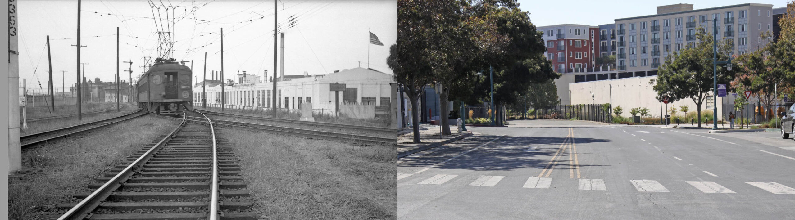
Now with the tower in the background, this no. 5 train engages the switch track at Ninth St. Junction as it passes the ca. 1916 Marchant Calculating Machine Co. factory in this undated post-Dec. 1938 southwest image. As for John’s shot in the right panel, his photographic career is a reminder that “before-and-after” sequences are only relative, and don’t always survive the test of time. Someone will always come up with an earlier image, and many of his “after” images he took over the years are now “before” for present and future photographers.
L327-20-Courtesy BAERA, Western Railway Museum Archives, l, John Harder Photo, Courtesy John Harder, r, (Image 4 of 35)
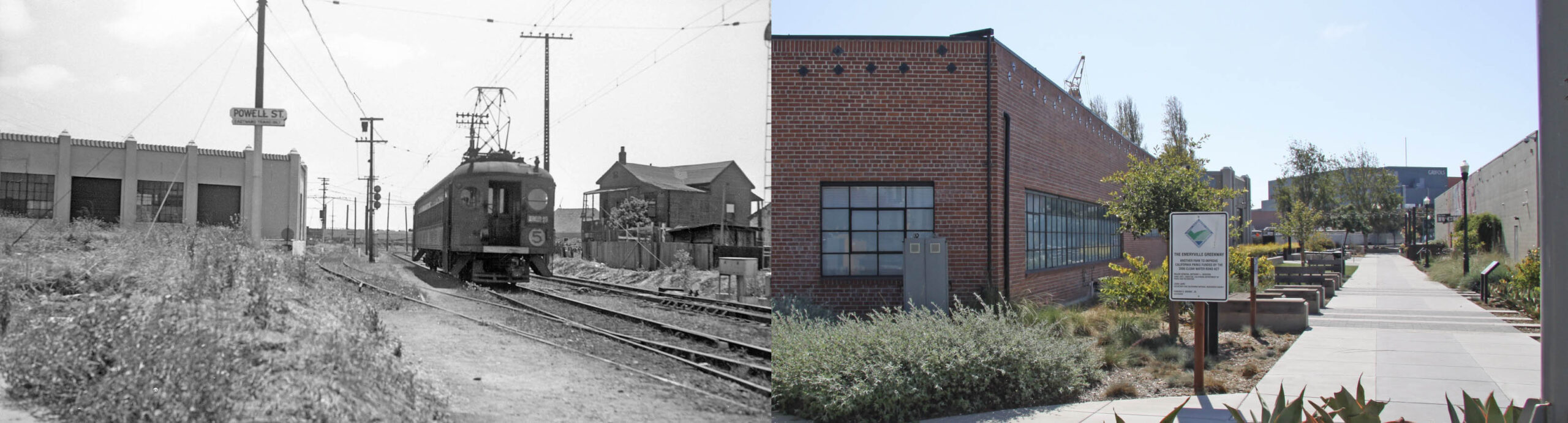
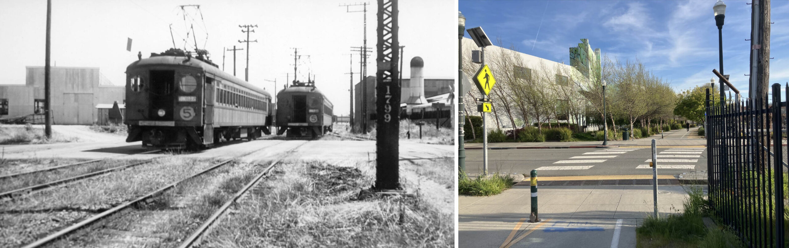
Still at the Junction, this northeast view from late 1938 catches a no. 5 train joining the line that sent the nos. 3 and 9 trains to-and-from Berkeley via Adeline St. and Shattuck Ave. No. 5701 Hollis St. is seen adjacent to the train in this northwest view. The building was first occupied by National Biscuit Co. from 1928 until at least 1930, by Lubrium Laboratories Inc., no later than 1933 until at least 1939 with annotations in the 1938 directory for motor engineering, graptiited lubrication, chemical works. In 1940, Precision Engineering Co. is listed there.
L327-25-Wilbur C. Whittaker Photo, Ford Collection, Courtesy BAERA, Western Railway Museum Archives, 86216ier, l, John Harder Photo, Courtesy John Harder, r, (Image 5 of 35)
The north face of the building at no. 5701 Hollis St. seen in the southwest view at the Powell St. stop for outbound or eastward passenger trains from 1941, left, is now obscured by the brick structure at 5703 Hollis St., right. This added structure is present in the 1950 Sanborn Map panel no. 266 from 1950, but not from aerials as late as 1945. The house to the west or right of the train did not outlast WWII.
L327-30-Addison Laflin Photo, Courtesy BAERA, Western Railway Museum Archives, 50689ier, l, John Harder Photo, Courtesy John Harder, r, (Image 6 of 35)
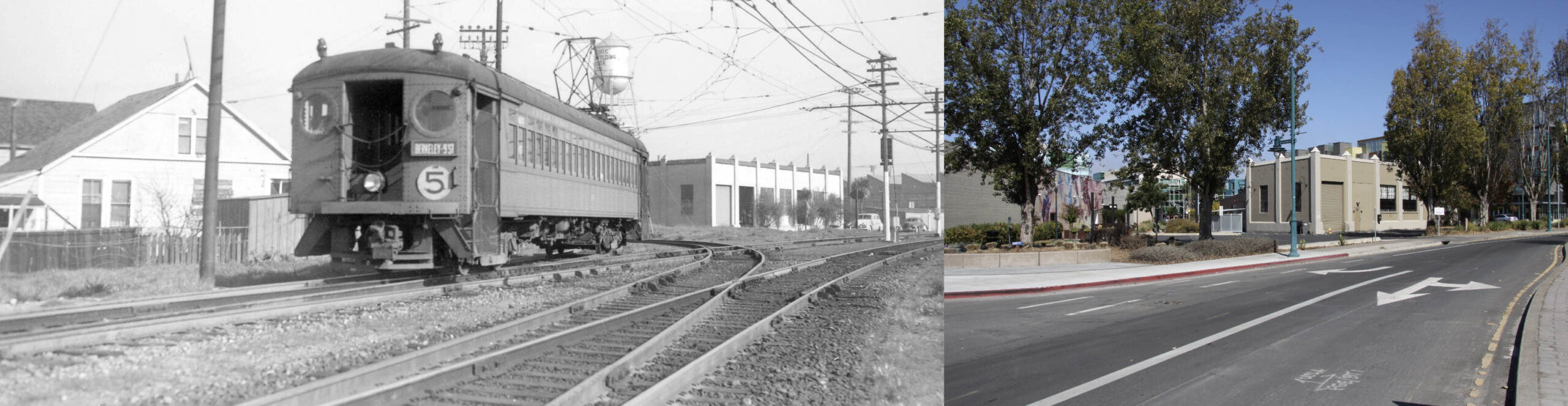
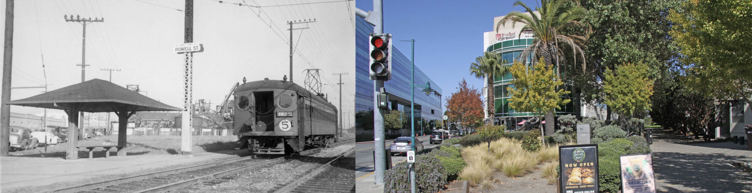
Passengers heading inbound westward to San Francisco on a no. 5 train had a small shelter and bench at the Powell St. stop shelter across the intersection as seen in this northeast view from Jan. 28, 1941. The view on the right from 2024 shows the transition from the previous industrial setting to healthcare and tech. Robert Ford notes this stop was listed by the SP and IER as “9th and Powell”, 9h St. being at least four blocks east at this point.
L327-40-Wilbur C. Whittaker Photo, Robert Ford Collection, Courtesy BAERA, Western Railway Museum Archives, 169823ier, l, John Harder Photo, Courtesy John Harder, r, (Image 7 of 35)
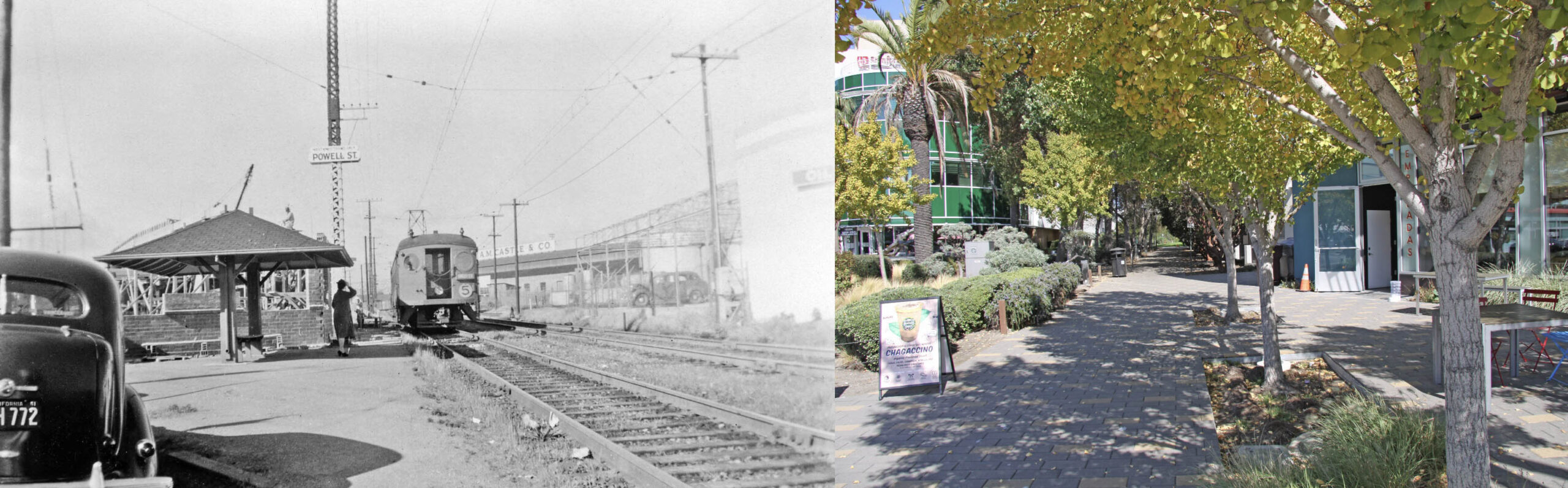
Peter Kyhn included a 1941 license plate in this northeast view at the inbound Powell St. stop. Note the A.M Castle & Co. sign replacing the one for Liberty Iron Works that had been there until about 1936 or so. Note the building being erected behind the shelter, to be addressed next. In 2024, the trail for the next block is a good place to escape the sun, right.
L327-45-Peter Kyhn Photo, Courtesy BAERA, Western Railway Museum Archives, l, John Harder Photo, Courtesy John Harder, r, (Image 8 of 35)
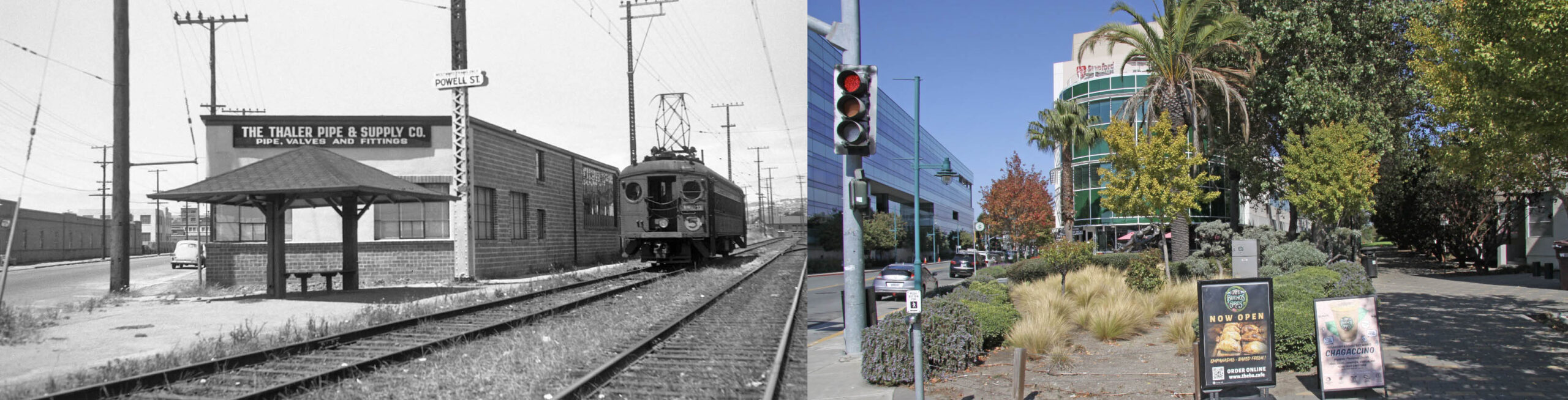
Knowing the previous image of the building under construction was taken in 1941, the date of this north view was probably close to the time of abandonment of the railway in July of 1941, when Addison Laflin walked the line taking many of the images seen in this presentation. The Thaler Pipe and Supply Co. would be the initial occupant, still a SP freight customer in 1957 at 5812 Hollis St. based on the Western Pacific Circular no. 167, with a siding capable of handing one freight car.
L327-50-Addison Laflin Photo Courtesy BAERA, Western Railway Museum Archives, 50690ier, l, John Harder Photo, Courtesy John Harder, r, (Image 9 of 35)
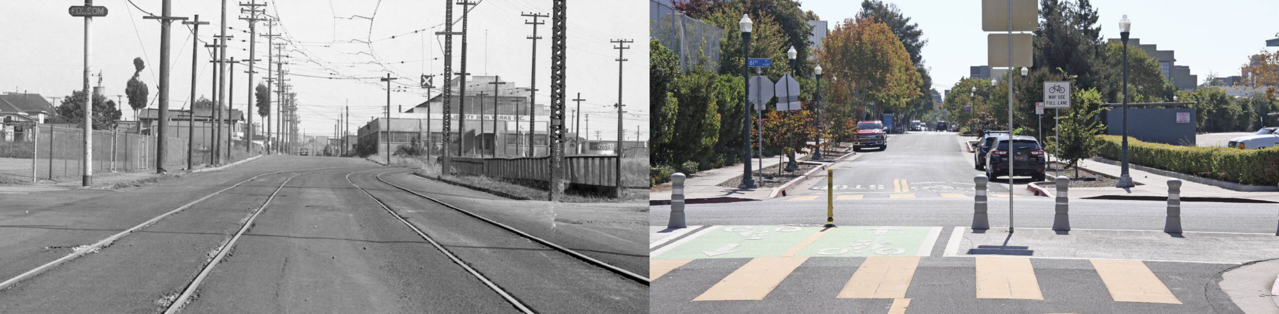
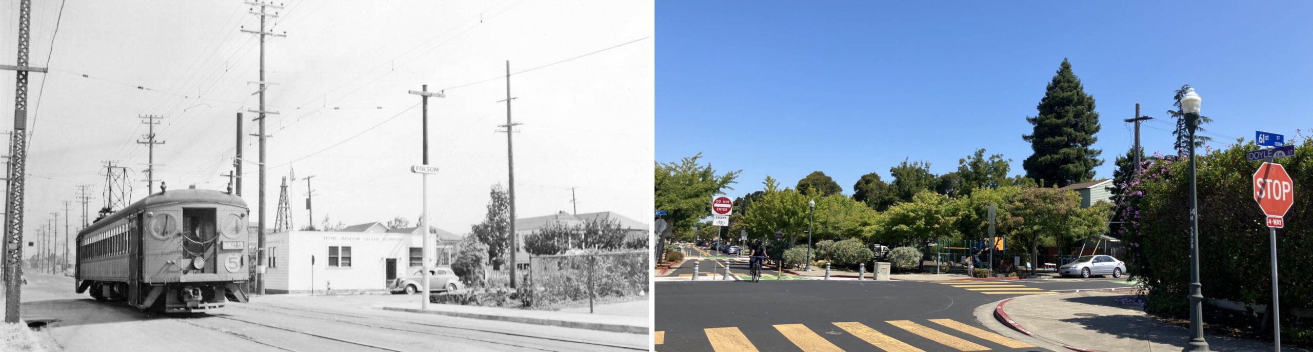
One of John’s photos viewed to the south down Doyle St. on the right is placed against one not from the IER era, but instead from 1934, the Liberty Iron Works and Pennzoil signs as clues as to the time period. The 61st St. stop was called Folsom during the entire electric era. John had the difficult task working around the sign on the road, but his view captures the outline of the Liberty building, the trees lining the curve of the parking lot, center right edge, that replaced the private right-of-way of the railway, and the heightened school yard fence on the left edge.
L327-55-SP Official Photo, Sappers Collection, Courtesy BAERA, Western Railway Museum Archives, 170925oa&b, l, John Harder Photo, Courtesy John Harder, r, (Image 10 of 35)
Two pairs of views facing north, first here between 59th St. and the Folsom stop at 61st St., left. To the left of the train is a building belonging to precast concrete-specialists Forni Manufacturing Co., and the larger building to the north of it housing Western Waxed Paper Co. of Ca., a Division of Crown Zellerbach Corp. John’s view on the right again contrasts the former industrial milieu with the proliferation of trees and shrubs around two of Emeryville’s parks.
L327-60-Addison Laflin Photo, Courtesy BAERA, Western Railway Museum Archives, 70213ier70213, l, John Harder Photo, Courtesy John Harder, r, (Image 11 of 35)
Again at the Folsom stop, a closer look at the Home Window Shade Co., left. The 1911 Sanborn map denotes the cross street as 61 St., but published general maps did not all agree with this until after WWI. The 1941 directory consulted to match the year of this photo listed the Home Window Shade Co. at no. 1296 61st St. John’s view on the right shows what eventually replaced the building, the “61st Street Mini Park”, built in 1976 as the first park in Emeryville. No other IER train images were found until the next one that follows taken at Ocean Ave.
L327-65-Courtesy BAERA, Western Railway Museum Archives, l, John Harder Photo, Courtesy John Harder, r, (Image 12 of 35)
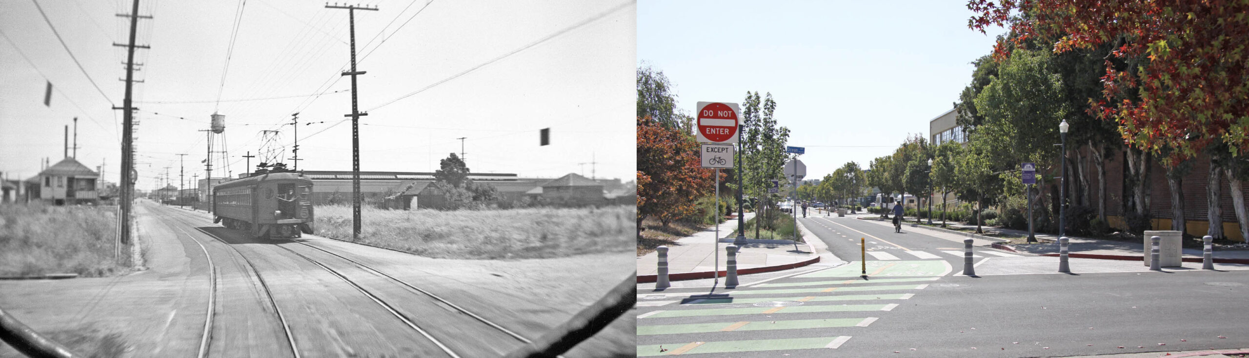
A south view from the rear of an outbound or eastward no. 5 train on July 6, 1941, left, shows empty lots on both south intersections with Ocean Ave., and the rear of a westward train. In the distance to the west or right of the train line is Detroit Steel Products Co.-Fenestra Steel Window Co. The corner lot on the southeast intersection is still unoccupied in 2024, right. Note the water tower on the left is absent in 2024, right. Moore Business Forms, Inc. moved the tower to Powell St. and Doyle St. based on the 1951 Sanborn map.
L327-70-Moreau Collection, Courtesy BAERA, Western Railway Museum Archives, 122318ier, l, John Harder Photo, Courtesy John Harder, r, (Image 13 of 35)
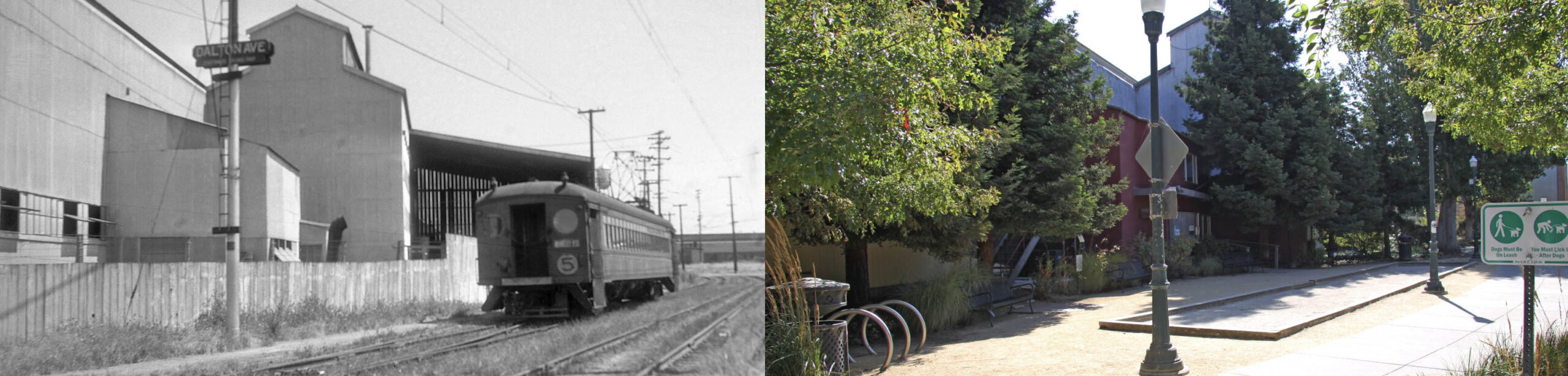
The southwest view on the left from the Dalton Ave. stop, now 65th St., shows the no. 5 train back on private right-of-way as it passes the spur track from Janson Iron Works in the 1930s, later Yuba Mining Co., then Baker Metals. The small, two story appendage on the left is shown by John Harder’s image on the right to serve as office space. The rest of this enormous pioneer industrial structure has been a decade plus on the agenda for development of the Emeryville Planning Commissioner, and it appears that in 2025, 17 work-live units will be introduced.
L327-75-Addison Laflin Photo, Courtesy BAERA, Western Railway Museum Archives, 50691ier, l, John Harder Photo, Courtesy John Harder, r, (Image 14 of 35)
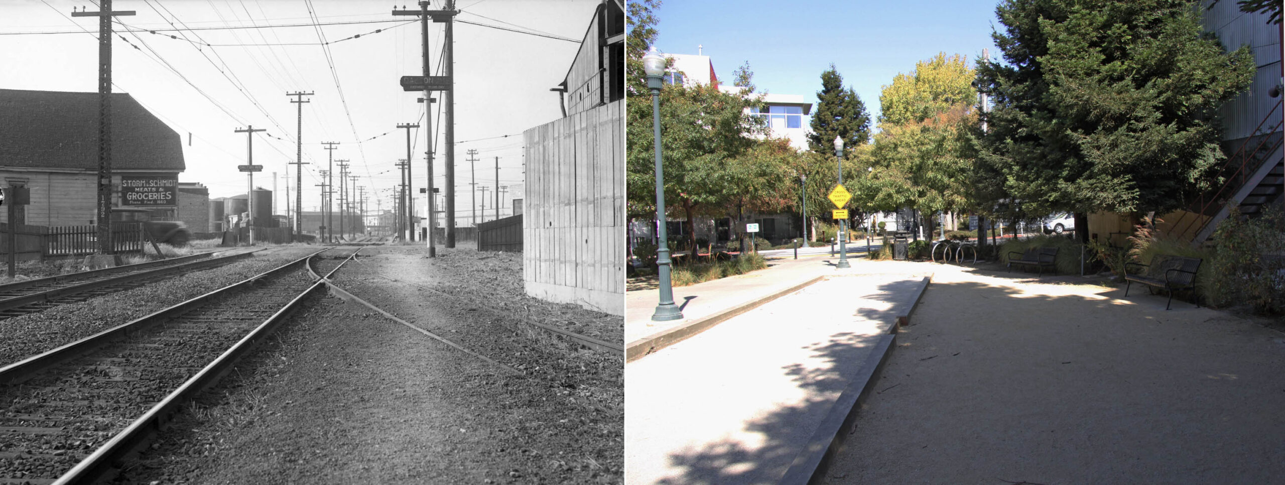
The northeast view matching John’s 2024 image on the right is from a 1934 shot taken from that Janson Iron Works spur track at the Dalton Ave. stop. Emeryville Chemicals is directly across Dalton Ave. to the north of the grocery store on the left, the Liquid Sugar Lofts now covers the whole next block in 2024, right. More on Liquid Sugar next time.
L327-80-SP Official Photo, Sappers Collection, Courtesy BAERA, Western Railway Museum Archives, 170926oa&b, l, John Harder Photo, Courtesy John Harder, r, (Image 15 of 35)
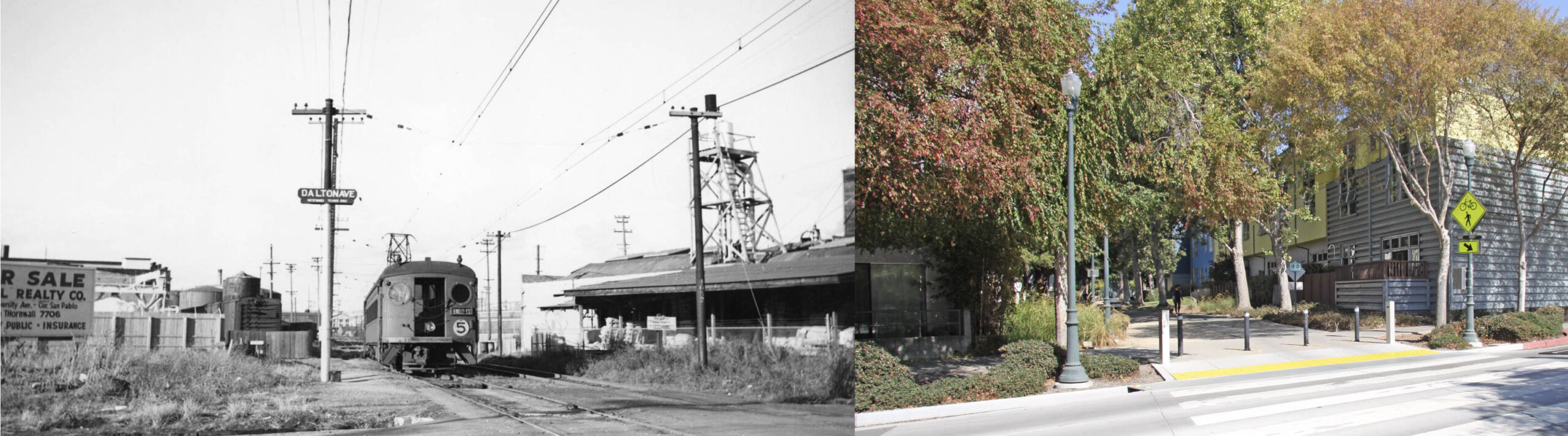
Another northeast view from the Dalton Ave. stop, but this one ca. 1940, shows the grocery is history and the lot for sale. Across the way was Vitamin Concentrate Manufacturing Co. in 1931, but the directory from 1940 lists National Oil Products and Vitab Corp. at no. 1256. On the right, across from Liquid Sugar Lofts, is no. 1256 65th St., since converted to the Oliver Lofts, more about the origin of the name next time.
L327-85-Courtesy BAERA, Western Railway Museum Archives, l, John Harder Photo, Courtesy John Harder, r, (Image 16 of 35)
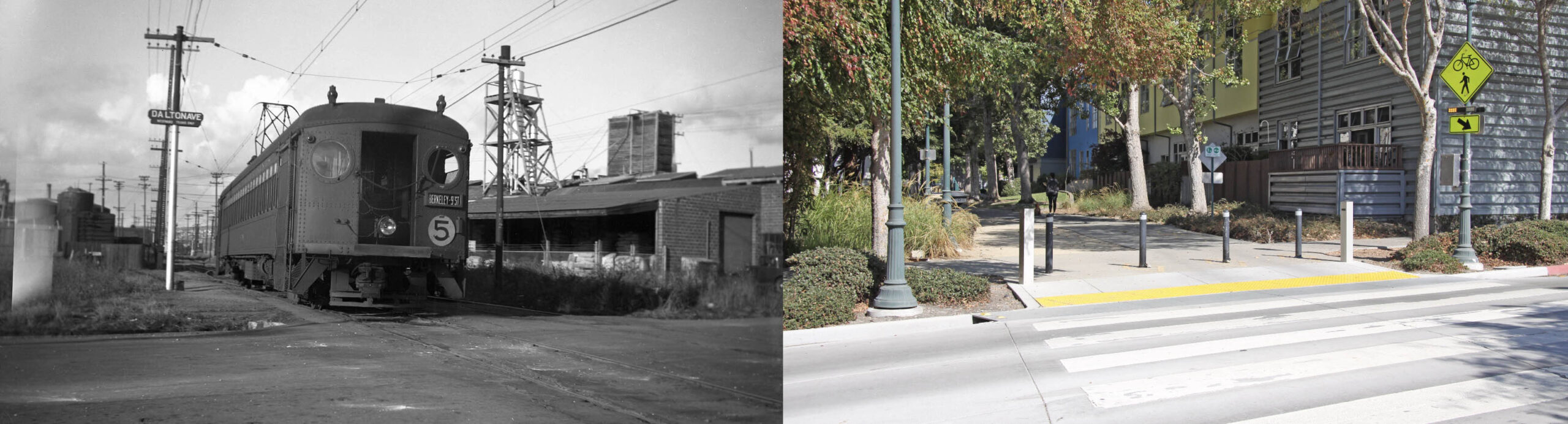
Another ca. 1940 northeast from the south side of the Dalton Ave. intersection, provides a little more detail of the structures discussed in the previous panels.
L327-90-Courtesy BAERA, Western Railway Museum Archives, 70214ier, l, John Harder Photo, Courtesy John Harder, r, (Image 17 of 35)
Now in Berkeley, two no. 5 trains pass at the grade crossing across Folger Ave., southwest view, 1941, left. To the east or left is a portion of the new factory for the Marchant Calculating Machine Co. from 1940, and to the west the Folger Ave. Mill and Lumber Co. from 1923. John’s image on the right shows the full-square block building and the tri-city border mural on the left edge. The right edge shows a parking lot for the adjacent Geo. M. Martin Co., the machine shop experts from 1940, also occupying the brown building behind then pole in the distance, the former Doughnut Corp. of America building from 1939 at 1255 67th St.
L327-92-Addison Laflin Photo, Courtesy BAERA, Western Railway Museum Archives, XXXXier, l, John Harder Photo, Courtesy John Harder, r, (Image 18 of 35)
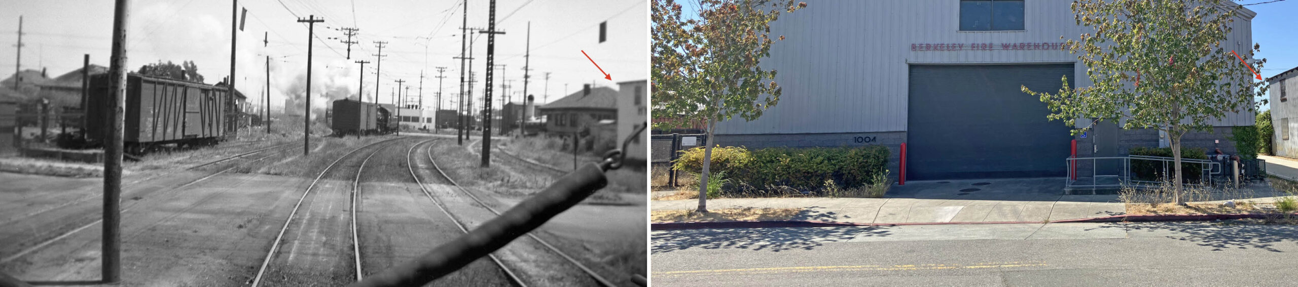
The IER moved the Murray St. stop to revamped Ashby Ave., the former station sign absent in this southwest view from July 6, 1941, left, featuring a steam switcher at Folger Ave., and the new Marchant factory to its right. The boxcar sits on a former siding for Huddart Lumber Co., the 1940 directory showing no business here. The Berkeley Fire Warehouse was placed on the right-of-way in 2011, coinciding with extension of the Greenway into Berkeley, right, on the former connecter track to the SP mainline along the Bay. John has expertly matched the surviving Hygenic Dog Food Co. building from 1937, red arrows, right edges.
L327-95-Moreau Collection, Courtesy BAERA, Western Railway Museum Archives, 122319ier l, John Harder Photo, Courtesy John Harder, r, (Image 19 of 35)
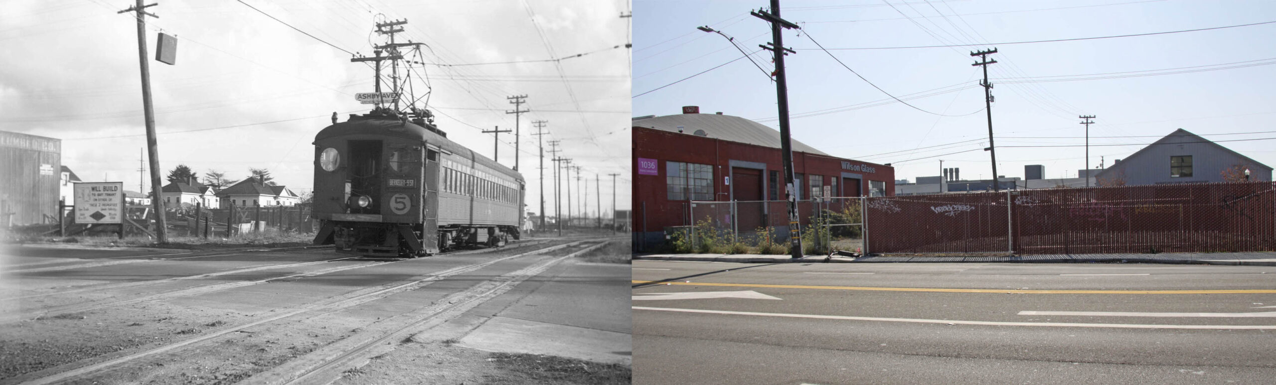
The IER Ashby Ave. stop for eastward trains is seen in this south view from 1939, left. The switch to Ashby Ave. recognized the new importance of the road as the connector to the Eastshore Highway, completed in 1934. The 1940 directory lists Albany Concrete Co at no. 1036 Ashby, seen to the left of the train with “Lumber” embossed on its western face. In 2024, right, the right-of-way is a fenced-off lot, the Greenway pushed outside the boundaries of the former rail line, and, therefore, left out of this view on purpose to match the scene from 1939.
L327-100-Addison Lafllin Photo Courtesy BAERA, Western Railway Museum Archives, l, 70221ier, John Harder Photo, Courtresy John Harder, r, (Image 20 of 35)
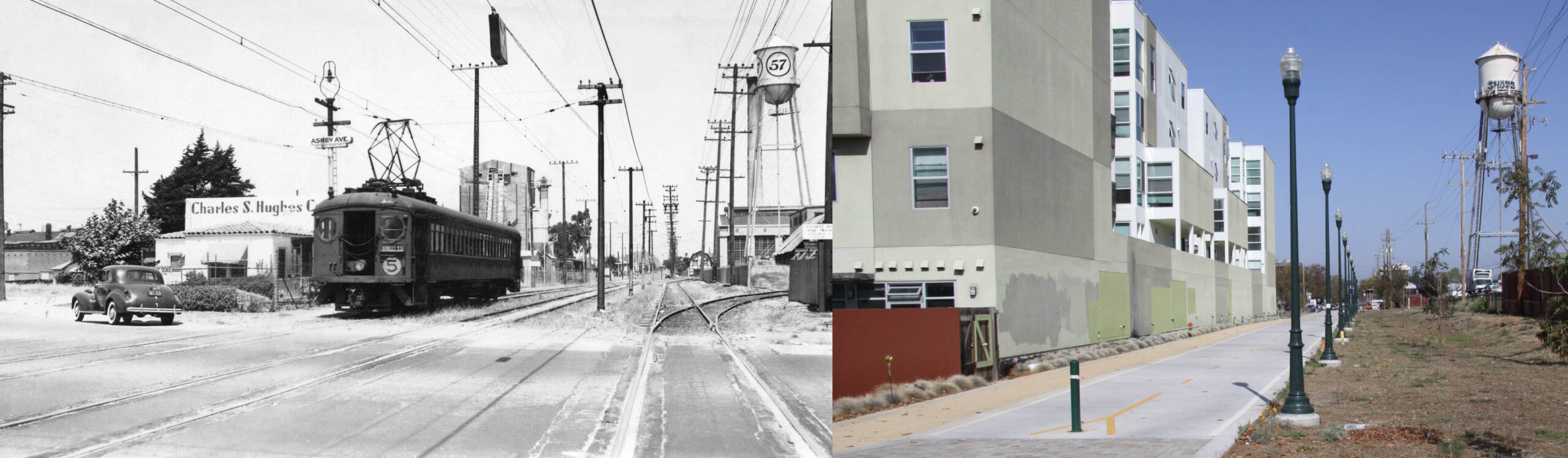
The no. 5 westbound train sits on the north side of Ashby Ave. at the westward stop ca. 1940 alongside Charles S. Hughes Co., a firm that specialized in building material dated with building permits dating from 1933 and 1935. The two spur tracks into Heinz Co. are seen along the right side. Once north of Ashby Ave., the trail shifts to the east, and again coincident with the abandoned right-of-way, right, alongside Berkeley Lofts, John perfectly lining up the The Heinz water tower in both scenes.
L327-105-Erle Hanson Photo, Moreau Collection, Courtesy BAERA, Western Railway Museum Archives, 167207ier, l, John Harder Photo, Courtesy John Harder, r, (Image 21 of 35)
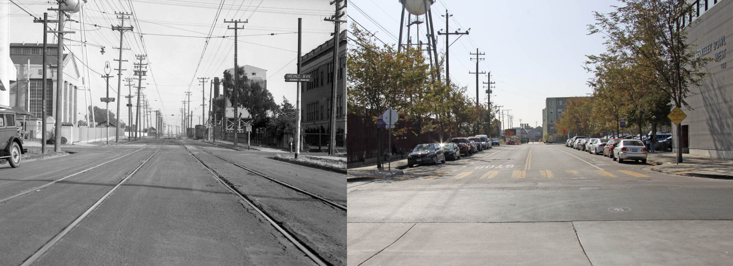
John’s image on the right looks south down Ninth St. from north of Heinz Ave., and shows that the Berkeley Bowl West occupies land that was once occupied by Hawthorne School, left, the latter image from 1934. It had served as a school starting in 1909, a storage facility for the Berkeley Public school system in the 1920s, and by this time, occupied by Heinz. The freights lined up along Hughes’ imposing structures are positioned for work.
L327-110-SP Official Sappers Courtesy BAERA, Western Railway Museum Archives, 170928oa&b, l, John Harder Photo, Courtesy John Harder, r, (Image 22 of 35)
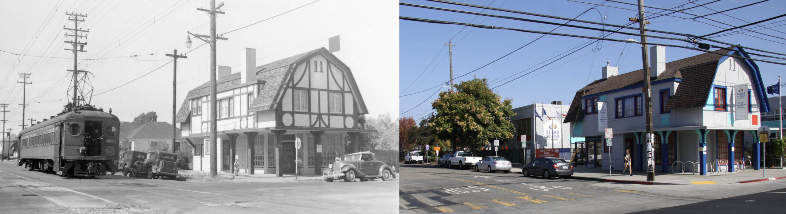
John Harder concluded his walk up the Ninth St. line at Heinz Ave. and Ninth St. with this northeast view of 1001 Heinz Ave., right, to match Will Whittaker’s same view from July 8, 1941, left, just two and a half weeks before Ninth St. passenger service ceased. The last update discussed this building, click here. The comparative images presented cannot explain everything that occurred around the IER in the 1930s, and, in fact, there are gaps where no photographic record could be provided. To leave a more complete history, aerials will follow.
L327-115-Wilbur C. Whittaker Photo, Ford Collection, Courtesy BAERA, Western Railway Museum Archives, 169827ier, l, John Harder Photo, Courtesy John Harder, r, (Image 23 of 35)
Shown here are vertical aerials from 1931 and 1938 as labeled, turned such that north is to the right. It would have been more effective to have an aerial from 1941, but other vertical views 1931-1965 could not be found. The 1938 aerial created by Harrison Ryker, however, is superior in quality to any USDA aerial, even if available. Ryker had set up his company by 1940 along the railway at 1000 Ashby Ave. producing pocket and desktop stereoscopes, and a vertical Sketchmaster, used by educational institutions and the military, especially during World War II. For more, click here.
L327-120-c-1820_47, c-1820_48 Fusion, Courtesy of UCSB Library Geospatial Collection, l, Harrison Riker Photo V5-149, Courtesy California Department of Transportation, r, (Image 24 of 35)
The comparative aerial review begins at the north border in South Berkeley of the future Greenway. No major changes: 1, Heinz; 2, Folger Ave. Mill and Lumber Co.; 3, SF Sulphur; 4, Hawthorne School occupied by Heinz. Major additions: 5, Ashby Ave reconfiguration.; 6, Charles Hughes; 7, Hygenic Dog Food Co. Businesses or structures to be added between 1939-1941: 8, Marchant Calculating Co., Berkeley side. The red arrow points to a rail spur back to the SP mainline along the Bay. Next, more detail on Ashby Ave., the rail spur and Marchant.
L327-125-c-1820_48, Courtesy of UCSB Library Geospatial Collection, l, Harrison Riker Photo V5-149, Courtesy California Department of Transportation, r, (Image 25 of 35)
These comparative views show the reconfiguration of Ashby Ave. to connect South Berkeley to the Eastshore Highway, the latter completed in 1934. The red arrows show the spur that connected the Ninth St. line to the SP mainline along the Bay. Although initially functioning as a way to move freight or inoperable passenger trains away from the Ninth St. operation, it would later accelerate the creation of an industrial corridor along Potter St.
L327-130-c-1820_48, Courtesy of UCSB Library Geospatial Collection, t, Harrison Riker Photo V5-149, Courtesy California Department of Transportation, b, (Image 26 of 35)
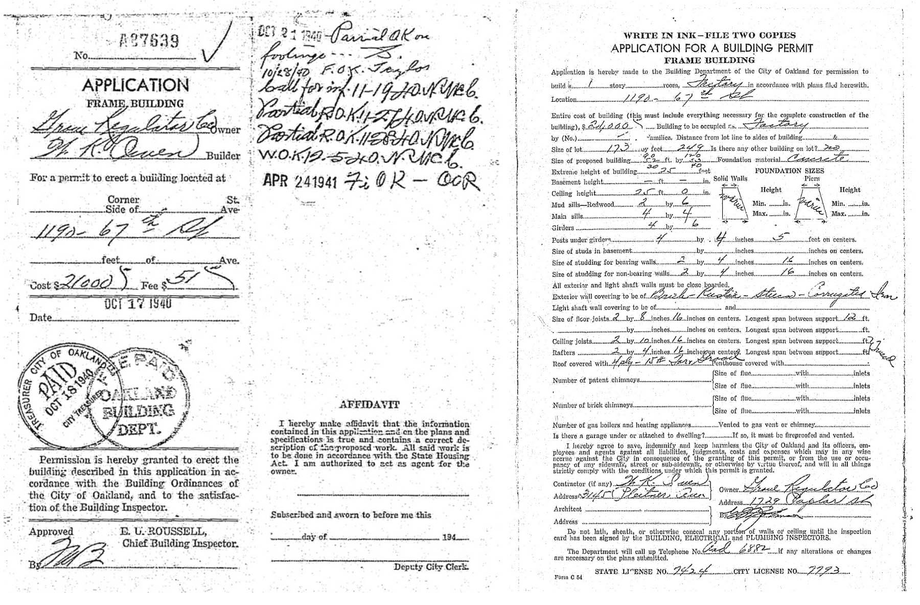
Addition of the new Marchant Calculating Co. factory that fronted on 67th St. in 1940 and shown pictorially in L327-92 and L327-95 was made through the permit process solely conducted in Oakland in 1940. The permit confirming this event is exhibited here, note that Marchant is not listed as the owner as this new facility was initiated.
L327-135-Courtesy City of Oakland, (Image 27 of 35)
No major physical changes: 9, Emeryville Chemical Co. Major additions: 10, expansion of F.A.B. Manufacturing Co.; 11, Vitamin Concentrate Manufacturing Co. is now two side-by side operations 12, Vitab Corp., and 13, National Oil Products. Businesses or structures to be added between 1939-1941: 14, Doughnut Corp. of America in 1939; 15, Geo. M. Martin Co. in 1940; 8, Marchant Calculating Co., Oakland side, continued from L327-125.
L327-140-c-1820_48, Courtesy of UCSB Library Geospatial Collection, l, Harrison Riker Photo V5-149, Courtesy California Department of Transportation, r, (Image 28 of 35)
No major physical changes: 16, Janson Iron Works, out of business ca. 1933; no listing for occupant of building in 1940; 17, Detroit Steel Products-Fenestra Steel Window Co.
L327-145-c-1820_47, Courtesy of UCSB Library Geospatial Collection, l, Harrison Riker Photo V5-149, Courtesy California Department of Transportation, r, (Image 29 of 35)
No major physical changes: 18, Pioneer Laundry post its 1931 expansion; 19, Forni Manufacturing Co.; 20, John A. Sutter Elementary School; 20b, North Emeryville School, replaced by no. 20 in 1929, occupant unknown; 21, Associated Oil Co. Automotive Dept. Major additions: 22, Western Waxed Paper Co. of California, a Division of Crown Zellerbach Corp. The corporate history is much more complicated, click here for more.
L327-150-c-1820_47, Courtesy of UCSB Library Geospatial Collection, l, Harrison Riker Photo V5-149, Courtesy California Department of Transportation, r, (Image 30 of 35)
No major physical changes: 23, Union Oil Co.; 24, Pennzoil; 25, Liberty Iron Works, although still unclear if they physically occupied this building in 1931, but by 1938, occupied by A.M Castle & Co.; Major additions: 26, Pacific Manifolding Book Co. Businesses or structures to be added between 1939-1941: 27, The Thaler Pipe and Supply Co., 1941.
L327-155-c-1820_47, Courtesy of UCSB Library Geospatial Collection, l, Harrison Riker Photo V5-149, Courtesy California Department of Transportation, r, (Image 31 of 35)
Finally to the south border where the Ninth St. IER line branched off at Stanford Ave. No major physical changes: 28, National Biscuit Co. was here in 1930, Lubrium Laboratories Inc., and engineering firm was here in 1933-1938, but no records between 1930-1933. Major additions: 26, Pacific Manifolding Book Co. (same buildings as in L327-155.)
L327-160-c-1820_47, Courtesy of UCSB Library Geospatial Collection, l, Harrison Riker Photo V5-149, Courtesy California Department of Transportation, r, (Image 32 of 35)
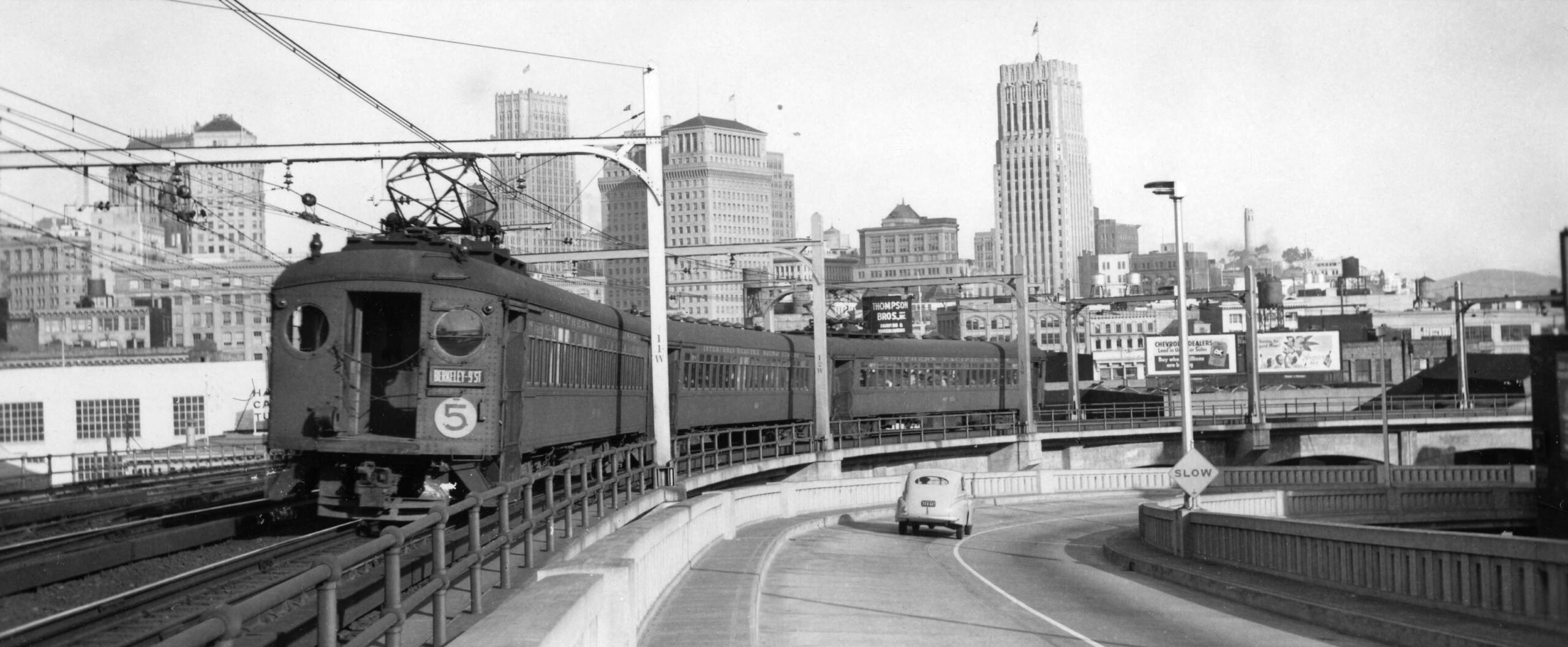
Railfans knew the IER as a whole was on a short timeline after the company filed for abandonment of passenger service at the end of Feb. 1940. That clearly led to an uptick in photos, but taking views of no. 5 trains on the industrial setting of the future Greenway could not compete with ones such as this northeast view of the San Francisco skyline and the rear of a no. 5 train heading to the Bay Bridge in 1941.
L327-165-Ken Kidder Photo, Courtesy BAERA, Western Railway Museum Archives, 214397ier, (Image 33 of 35)
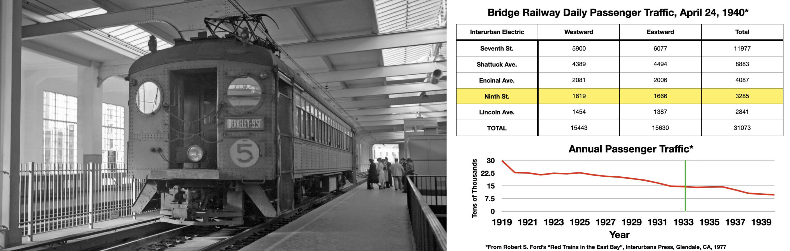
Two very important sets of data compiled by Robert Ford in his book are provided next to a no. 5 train at the Transbay Terminal in San Francisco, about to board passengers five days before abandonment, July 20, 1941. The Ninth St. line was historically a poor revenue generator relative to the other IER lines. It carried less passengers than any of the Key System interurbans as well. The graph shows the downward trend in ridership of the entire IER system was not stalled by the consolidation of lines with the Key System in 1933, green line, or by creating the IER and inserting the Bay Bridge instead of a ferry.
.
L327-170-Louis Bradas, Jr. Photo, Courtesy BAERA, Western Railway Museum Archives, 68795ier, (Image 34 of 35)
The update ends with a southwest view from the Bay Bridge by Peter Kyhn, probably from a Key interurban as he was a Key employee, showing the rear of a no. 5 train heading to the terminal on the last day of operation, July 25, 1940. Life after the death of passenger service of the Ninth St. line is next. Appreciation to John Harder for making this comparative photographic display, and to Daniella Thompson for research on the dates and occupants of structures built in Berkeley.
L327-175-Peter Kyhn Photo, Moreau Collection, Courtesy BAERA, Western Railway Museum Archives, 124256ier, (Image 35 of 35)