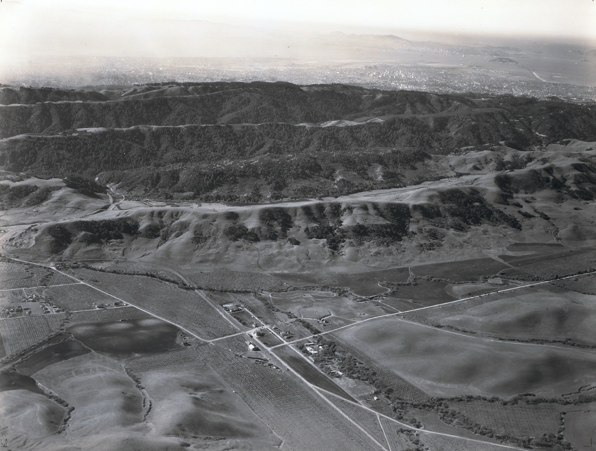
Moraga Comparative Views 1935 vs. 1960s

The Mainline Moraga section covered the 1950s. As a reference for ground level images of central Moraga, images from 1935, such as this southwest view, and those after SN abandonment in the 1960s will be presented. EBRPD Ref. USNPS-10E
L6-05-HJW Geospatial Inc, Pacific Aerial Surveys, Oakland CA, Courtesy East Bay Regional Park Distr., (Image 1 of 11)

Ahead to 1962, same southwest view, documents reconfiguration of the roads and a modest population boom away from the town center. "Moraga's Pride" is strongly recommended to fill in the details. For a copy, contact the Moraga Historical Society at http://www.moragahistory.org
L6-10-Herrington-Olsen Photo, from the collection of the Moraga Historical Society, Moraga, CA, 7, (Image 2 of 11)

Back to 1935, watershed issues from the 1920s eliminated homes south of Camino Pablo that flourished when the SN was first built. Few homes are seen east of Canyon Road between Camino Pablo and Larch Road. See the annotated version that follows. Detail of L6-05. Detail EBRPD Ref. USNPS-10E
L6-15-HJW Geospatial Inc, Pacific Aerial Surveys, Oakland CA, Courtesy East Bay Regional Park Distr., (Image 3 of 11)

Annotated version of L6-15. The SN right-of-way is denoted by the yellow arrows, while the crossing at Moraga Creek is marked by a red arrow. Southwest view, 1935. Detail of L6-05. Detail EBRPD Ref. USNPS-10E
L6-16-HJW Geospatial Inc, Pacific Aerial Surveys, Oakland CA, Courtesy East Bay Regional Park Distr., (Image 4 of 11)

Moraga Road, Moraga Highway, or Way, and Moraga Creek are featured in this detail of L6-05 of the west portion of central Moraga in 1935. The hexagonal motif at the end of what is today Country Club Drive was part of the Moraga Company's Moraga Townsite plan of 1913. Detail EBRPD Ref. USNPS-10E
L6-20-HJW Geospatial Inc, Pacific Aerial Surveys, Oakland CA, Courtesy East Bay Regional Park Distr., (Image 5 of 11)

This detail from Mainline F-55, northwest view, 1935, shows Moraga Way and the current Moraga-Orinda border at Ivy Drive. EBRPD Ref. USNPS-11-0
L6-25-HJW Geospatial Inc, Pacific Aerial Surveys, Oakland CA, Courtesy East Bay Regional Park Distr., (Image 6 of 11)

Annotated version of L6-25, northwest view, 1935. The SN right-of-way is denoted by the yellow arrow, while the Moraga Creek is marked by red arrows. Detail EBRPD Ref. USNPS-11-0
L6-26-HJW Geospatial Inc, Pacific Aerial Surveys, Oakland CA, Courtesy East Bay Regional Park Distr., (Image 7 of 11)

To 1960, the SN is now history in Moraga. Appreciate the dramatic growth to the north of Moraga Way, and to the east of Canyon Road with the addition of Sanders Drive. Protection of the water supply still limited the population growth to the south and west, foreground. H-O Ref. A-2919
L6-30-Herrington-Olsen Photo, from the collection of the Moraga Historical Society, Moraga, CA, (Image 8 of 11)

Detail of L6-25, 1960, northwest view, shows the town center with revamped road configuration, addition of Sanders Drive and the Moraga Shopping Center. The latter has yet to encroach on the outlines of the previous road configuration and SN. H-O Ref. A-2919
L6-35-Herrington-Olsen Photo, from the collection of the Moraga Historical Society, Moraga, CA, (Image 9 of 11)

This northeast view, 1960, provides detail of Lamorinda and the population growth in the Rheem Valley, Lafayette, out to Walnut Creek, all prominent in the background. Miramonte High School, prominent in the foreground, was founded in 1955. H-O Ref. A-2882
L6-40-Herrington-Olsen Photo, from the collection of the Moraga Historical Society, Moraga, CA, 6, (Image 10 of 11)

Detail of northeast view, 1960, provides more detail of the Moraga town center. The SN right-of-way, starting from the bottom, right, is still intact up to the new origin of St. Mary's Road, upper right. A small curve was added to the road, creating the east border for the future creation of the Moraga Commons. H-O Ref. A-2882
L6-45-Herrington-Olsen Photo, from the collection of the Moraga Historical Society, Moraga, CA, 6, (Image 11 of 11)