Mountain Boulevard Freeway – Bridging Broadway Terrace

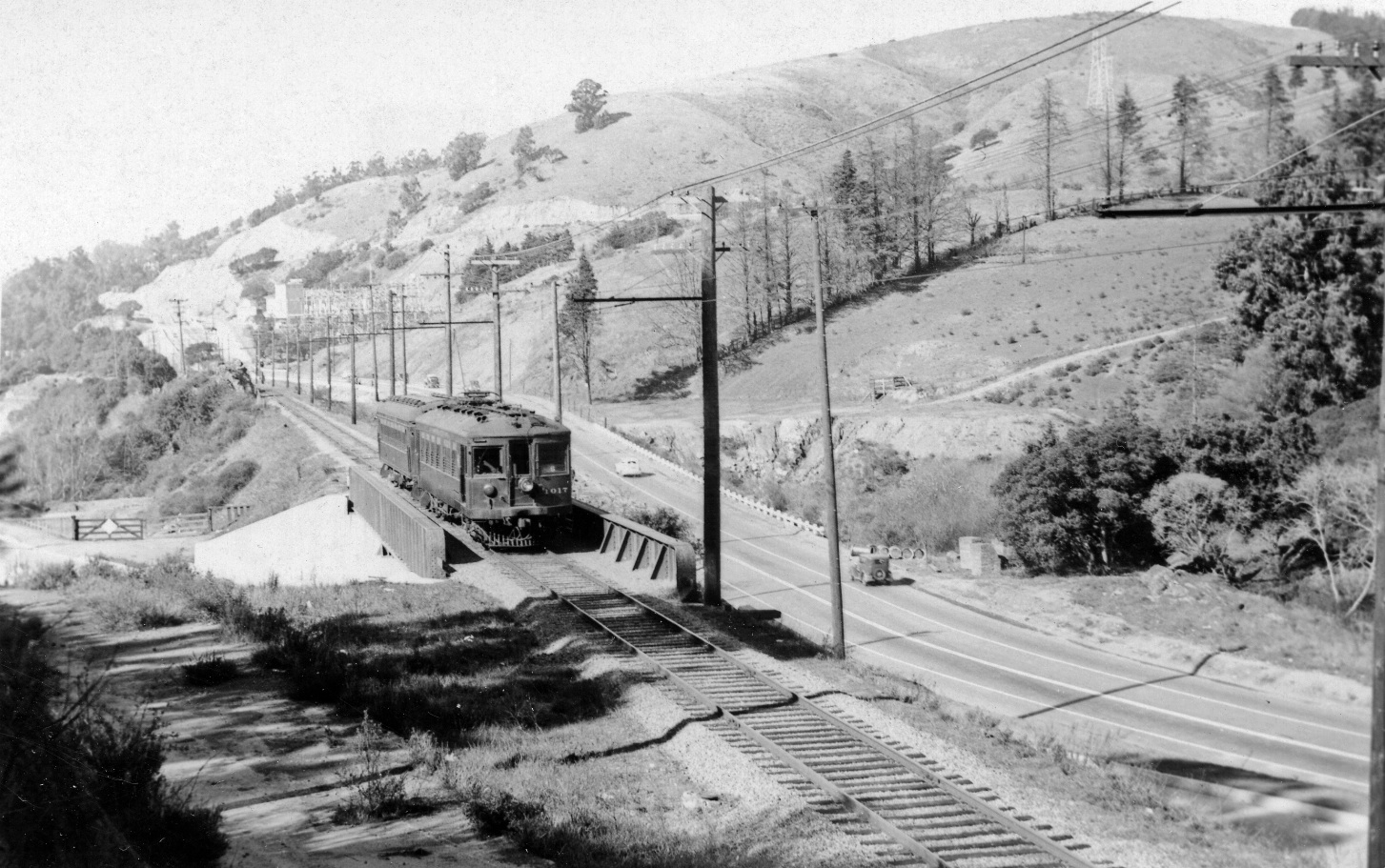
SN train 6 composed of SN 1017 and trailer SN 1012 head southeast across the Broadway Terrace overpass on Feb. 2, 1940, north view. The structure was opened on Sep. 22, 1936 according to the Oakland Tribune. This section will present the construction of its neighbor to the east, the overpass for the Mountain Boulevard Freeway Unit One, MBFU1.
L70-05-Kenneth C Jenkins Photo 46501, Courtesy Garth Groff, (Image 1 of 21)

Before embarking on the freeway construction, some comparative images of this area. SN 1010 leads a two-car train onto the SN overpass in this east view from Jun. 28, 1941. Termination of passenger service is only days away. Note the Terrace shelter on the berm, and Hamilton’s Market in the distance.
L70-10-Courtesy Tom Gray, (Image 2 of 21)

This east image with SN 604 and freight circa 1950 shows a freeway construction crew to the south east of the overpass, although little work has yet begun. The entrance to Lake Temescal is to the left, and the coach stop sign sits prominently on the south side of Broadway Terrace.
L70-15-Tom Gray Photo, Courtesy Tom Gray, (Image 3 of 21)

Now to the east side of the overpass looking west, Apr. 22, 1950, SN 605 poses for the camera with street repair prior to freeway construction evident. Past the overpass, note the coach stop sign to the left, and the larger sign denoting the entrance to Lake Temescal, right.
L70-20-Tom Gray Photo, Courtesy Tom Gray , (Image 4 of 21)

A west view down Broadway Terrace showing the SN overpass prior to freeway construction, circa 1950.
L70-25-Public Works Photo, Oakland Cultural Heritage Survey, Oakland City Planning Department , (Image 5 of 21)

Compare the last image with this west view from late 1951, early 1952, a west view with the freeway overpass complete and ready for the opening day for traffic, Jan 22, 1952. The presence of the SN overpass is now obscured from this direction.
L70-30-Public Works Photo, Oakland Cultural Heritage Survey, Oakland City Planning Department , (Image 6 of 21)

To link image L70-25 to L70-30, the construction sequence for the various parts of the overpass will be presented starting with this west view from late 1950, early 1951 showing the initial construction of the freeway overpass.
L70-35-Public Works Photo, Oakland Cultural Heritage Survey, Oakland City Planning Department , (Image 7 of 21)

Although the official ground-breaking date for MBFU1 was Sept. 14, 1950, this northeast view from Aug. 11, 1949 is a reminder that substantial changes east of the SN right-of-way at Landvale Rd., top left, and the clearing of the west side of Glenwood Glade, bottom right, had already occurred.
L70-40-Public Works Photo, Oakland Cultural Heritage Survey, Oakland City Planning Department , (Image 8 of 21)

A southeast view of the same area from late 1949.
L70-45-Public Works Photo, Oakland Cultural Heritage Survey, Oakland City Planning Department , (Image 9 of 21)

This south view down the right-of-way from Feb. 2, 1951 shows the construction of the overpass in full swing. This dated image allows the images to follow to be dated to 1951.
L70-50-Public Works Photo, Oakland Cultural Heritage Survey, Oakland City Planning Department , (Image 10 of 21)

As the overpass is being started, the finishing touches to the new northeast on-ramp are evident, as is the cleared out section south of the overpass in this 1951 south view.
L70-55-Public Works Photo, Oakland Cultural Heritage Survey, Oakland City Planning Department , (Image 11 of 21)

Successive west views, A to D, of overpass construction in 1951. Image C is from May 15, 1951. The large sign in A and B identifies the Hedrickson and Watson Construction Co., Oakland CA.
L70-60-Public Works Photos, Oakland Cultural Heritage Survey, Oakland City Planning Department, (Image 12 of 21)

Next, east views, A to D, of overpass construction in 1951. Images C and D are from May 15, 1951.
L70-65-Public Works Photos, Oakland Cultural Heritage Survey, Oakland City Planning Department , (Image 13 of 21)

A north view from 1951, early in the overpass construction process. Note the PG&E facility in the distance.
L70-70-Public Works Photo, Oakland Cultural Heritage Survey, Oakland City Planning Department , (Image 14 of 21)

Another circa 1951 north view early in the construction process, this time with the right-of-way in full view.
L70-75-Public Works Photo, Oakland Cultural Heritage Survey, Oakland City Planning Department , (Image 15 of 21)

Now on the graded surface of what will serve as a dual function of the terminus of Glenwood Glade and the new freeway southeast off-ramp. North view of the south overpass retaining wall, 1951.
L70-80-Public Works Photo, Oakland Cultural Heritage Survey, Oakland City Planning Department , (Image 16 of 21)

The retaining wall of the new overpass here seen with the Pinewood Rd.- Broadway Terrace intersection in the background, northeast view, 1951.
L70-85-Public Works Photo, Oakland Cultural Heritage Survey, Oakland City Planning Department , (Image 17 of 21)

Same structure as in L70-85, but from the east side with a southwest view, 1951.
L70-90-Public Works Photo, Oakland Cultural Heritage Survey, Oakland City Planning Department , (Image 18 of 21)

A west view of mid-phase construction of the overpass, 1951.
L70-95-Public Works Photo, Oakland Cultural Heritage Survey, Oakland City Planning Department , (Image 19 of 21)

The overpass at completion, late 1951, early 1952, northwest view.
L70-100-Public Works Photo, Oakland Cultural Heritage Survey, Oakland City Planning Department , (Image 20 of 21)

Finally, a west view up Broadway Terrace from Jan. 2014, soon to be a “before” image for future Terrace generations ...
L70-105-Stuart Swiedler Photo, (Image 21 of 21)