Mountain Boulevard Freeway Unit 1 – Overview and Key Images

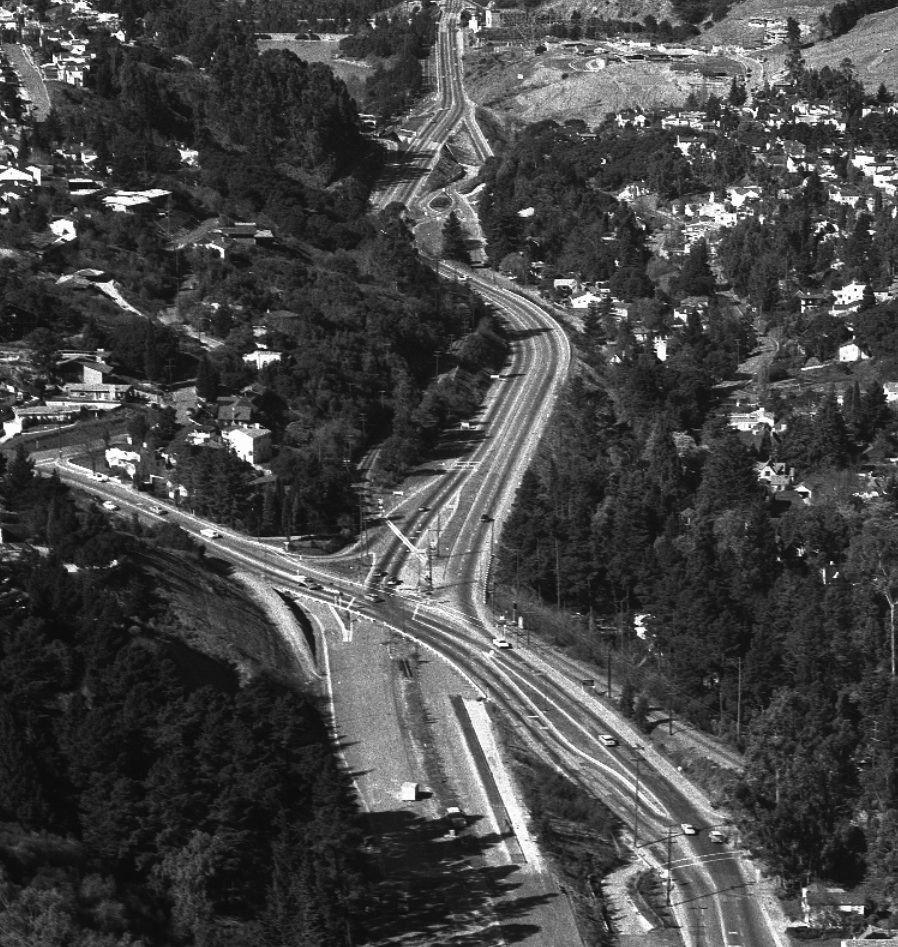
A northwest view of Mountain Boulevard Unit 1, MBU1 or Alameda 227 from Feb. 1, 1956, the precursor to Highway 13. This portion connected the 1937 reconfigured Landvale Road by Lake Temescal to Moraga Avenue. Delays in its construction highlight the mid-20th century Alameda County.
L31-05-Copyright California Department of Transportation, Detail 4809-2, (Image 1 of 11)

Ground breaking to completion of MBU1 covered Sept 13, 1950 to Jan. 22, 1952, respectively, based on Oakland Tribune accounts. Other activities besides clearing the canyon were begun as early as the early 1940s. Preconstruction south view, 1939.
L31-10-Courtesy Oakland History Room, Oakland Public Library, 267 or F-1200, (Image 2 of 11)

Visual cues from the SN, particularly catenary holder placement, distinctive trees, and homes all contribute to matching images prior to freeway construction to those after completion. Northwest view, circa 1950.
L31-15-Public Works Photo, Oakland Cultural Heritage Survey, Oakland City Planning Department , (Image 3 of 11)

The Broadway Terrace intersection from 1952, right, relative to that of 1950, left, included addition of an overpass for the freeway, addition of ramps with grade crossings for the SN on the west flank, and shifting and raising Landvale Road plus a ramp to the east. The position of the catenary wire poles relative to the SN track were not modified, a useful visual cue for images to follow.
L31-20-Public Works Photos, Oakland Cultural Heritage Survey, Oakland City Planning Department, (Image 4 of 11)

Before and after west views down Broadway Terrace show the addition of the freeway overpass relative to the SN overpass. The California license plates on the cars indicate the left panel is dated no later than 1950, while the right panel dates to 1951.
L31-25-Public Works Photos, Oakland Cultural Heritage Survey, Oakland City Planning Department, (Image 5 of 11)

Addition of the freeway, an off ramp to Broadway Terrace, necessitated removing the whole west portion of Glenwood Glade. The demolition or moving of homes from here and Fernwood Drive began in the early 1940s to hasten freeway construction, but was offset by funding shortfalls and other issues. The SN catenary poles across the road are west of the track. Southwest views, 1950 and 1951, left to right.
L31-30-Public Works Photos, Oakland Cultural Heritage Survey, Oakland City Planning Department, (Image 6 of 11)

These two south view images from 1950, left, and 1951, right, show an area between Broadway Terrace and Moraga Avenue. The large trees to the east or left allow the images to be matched. The crossing of the catenary poles relative to the SN track indicate that this site is south of Florence Avenue and its associated SN trestle. More later ...
L31-35-Public Works Photos, Oakland Cultural Heritage Survey, Oakland City Planning Department, (Image 7 of 11)

If not for the homes on Estates Drive overlooking the SN and the future freeway on the west, this north scene on the left circa 1950 could be mistaken for a remote forest. The rainy north view on the right shows the completed freeway in 1952. MBU1 ended here, cut off by Moraga Avenue as the latter paralleled the SN right-of-way.
L31-40-Public Works Photos, Oakland Cultural Heritage Survey, Oakland City Planning Department, (Image 8 of 11)

MBU1 ended at Moraga Avenue, so only after it was extended to Park Blvd. in 1956 did both the SN and and Moraga Avenue actually cross an active freeway. Comparison at Estates Drive and Moraga Avenue looking southeast before and during freeway construction is shown. Removal of all those trees exposed the SN and the Thornhill Drive trestle, visible in the distance in the right panel.
L31-45-Public Works Photos, Oakland Cultural Heritage Survey, Oakland City Planning Department, (Image 9 of 11)

The viewer stands on the hill along the southern and western edge of Moraga Avenue in this north view from circa 1949-50, left. The Eucolyptus tree in the distance, black arrow, is still at at the level of Florence Avenue today. The white arrow marks Moraga Avenue, just north of Thornhill Drive. Later, as the hill is removed, right circa 1950, the SN right-of-way comes into view, yellow arrow.
L31-50-Public Works Photos, Oakland Cultural Heritage Survey, Oakland City Planning Department, (Image 10 of 11)

Relative to L31-50, turning to the southeast circa 1949-50, left, and circa 1950, right, opens up Moraga Avenue and the SN to full view. Using each of the eight sets of before-and-after images presented, the complete story of the building of MBU1 will follow when the subject is picked up in the future.
L31-55-Public Works Photos, Oakland Cultural Heritage Survey, Oakland City Planning Department, (Image 11 of 11)