Much Ado About the West Portal

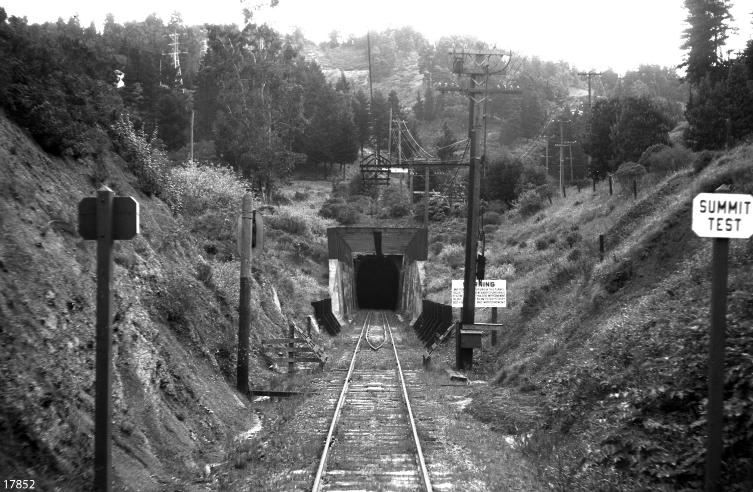
This undated east view of the SN west portal in Shepherd Canyon marks the summit of the Oakland grade and start of the 1.4% graded descent into Canyon. The utility poles in the upper right mark Park Boulevard, the original name of Shepherd Canyon Road.
L23-05-Courtesy BAERA, Western Railway Museum Archives, 17852sn, (Image 1 of 15)

This 1939 aerial view of the portal area establishes its relation to the sector demarcated by Park Boulevard, Saroni and Woodrow Drives. Note the absence of any homes directly along the right-of-way. An annotated version is next.
L23-10-USDA AAA Western Division Laboratories, Courtesy East Bay Municipal Utility District, Detail, (Image 2 of 15)

Annotated version of L23-10. The road configuration in 1939 is as it exists today. The portal is marked by the orange arrow, and the SN right-of-way by the yellow arrows.
L23-11-USDA AAA Western Division Laboratories, Courtesy East Bay Municipal Utility District, Detail, (Image 3 of 15)

This east oblique view from Apr. 22, 1960 confirms the relative stability of the configuration of the portal, SN right-of-way and roads in the canyon through abandonment in 1957. The home to the northwest of the portal was built in 1949.
L23-15-Copyright California Department of Transportation, 7453-10 Detail, (Image 4 of 15)

This undated east view appears to be taken directly above the right-of-way. The only utility poles are along the tracks, and the only visible road is Skyline Boulevard above. Next to examine how different the canyon was relative to L23-05.
L23-20-Cheney Photo H2147, Oakland Cultural Heritage Survey, Oakland City Planning Department, (Image 5 of 15)

Luckily there are a series of photos taken in succession complementing that of L23-20. This undated southwest view into Shepherd Canyon reveals a very wild and undeveloped landscape.
L23-25-Cheney Photo H2144, Oakland Cultural Heritage Survey, Oakland City Planning Department, (Image 6 of 15)

A closer view of L23-25 reveals the gentle curved approach of the SN right-of-way to the west portal. The presence of a bridge over the railroad cut will be explored next.
L23-30-Cheney Photo H2144, Oakland Cultural Heritage Survey, Oakland City Planning Department, (Image 7 of 15)

This eye-catching undated southwest view answers many questions but raises others. Park Boulevard appears to be no more than a dirt path at this location relative to the previous images. Two closer views of the same image follow.
L23-35-Cheney Photo H2149, Oakland Cultural Heritage Survey, Oakland City Planning Department, (Image 8 of 15)

The right portion of L23-35 shows a flume or bridge over the right-of-way, most certainly the spot from which image L23-20 was taken. A large pipe dips from this into the railroad cut. The portal itself is just outside the lower right corner. At best, there is a dirt path along the right-of-way.
L23-40-Cheney Photo H2149, Oakland Cultural Heritage Survey, Oakland City Planning Department, (Image 9 of 15)

The left portion of L23-35 shows an encampment near a clearing with a path to the portal. The path of today’s Shepherd Canyon Road is occupied by a flume, possibly related to Shepherd or Shephard Creek, but the scene demands additional visual documentation.
L23-45-Cheney Photo H2149, Oakland Cultural Heritage Survey, Oakland City Planning Department, (Image 10 of 15)

This east view of the SN Meteor from May 5, 1940 provides a glimpse of the surrounding area and markings along the right-of-way approaching the tunnel near the end of the passenger train era.
L23-50-Vernon Sappers Collection, Courtesy BAERA, Western Railway Museum Archives, 52064sn, (Image 11 of 15)

Although the portal is not visible in this image, the markings from the previous image locate this circa 1940 east view of a tunnel work train close to the portal. These special cars provided equipment and a refuge to workers spending extended periods of time in the 3200 foot tunnel.
L23-55-Paul Smith Photo, Courtesy BAERA, Western Railway Museum Archives, 54277sn, (Image 12 of 15)

Owing to the skills of the photographer, some views of the portal gave the impression of a straighter approach as in this 1937 east view ...
L23-60-Charles Savage Photo, Courtesy BAERA, Western Railway Museum Archives, 10171sn, (Image 13 of 15)

... while others, such as this east view with SN 661 from 1948, accentuated the gentle curve. However, it is the same unaltered tunnel approach.
L23-65-Roger Heller Photo, from the collection of the Moraga Historical Society, Moraga, CA, NN-61, (Image 14 of 15)

This section ends with a east view of the portal, a revealing look just after railroad abandonment in 1957. Note the sign just inside the tunnel, and the unkempt right-of-way. A further exploration of this area in the future will examine what happened next.
L23-70-Harre Demoro Photo, Courtesy John Harder, (Image 15 of 15)