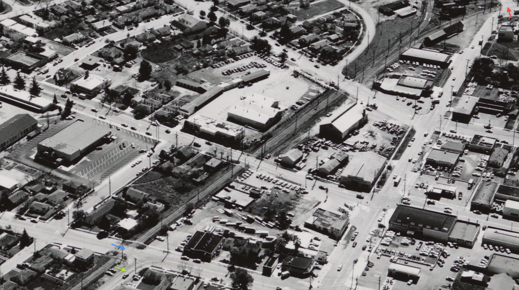
No Streets or Sidewalks Leaving the Depot

Although the SN remained on its own private right-of-way through central Concord, the three blocks north of the Clayton Rd. grade crossing, red arrow, to the one at Salvio St., blue arrow, lacked a parallel road or sidewalks until north of Salvio St. at the start of the Port Chicago Highway, green arrow. Southeast view, circa 1956. Ref: brk00017177_24a
L136-05-Clyde Sunderland Photo, Courtesy of The Bancroft Library, University of California, Berkeley, (Image 1 of 12)

It might be taken for granted that the right turn Clayton Rd. west takes after passing under BART has a long history, but this was SN right-of-way, the depot platform at the “speed limit 30” sign. North view.
L136-10-Stuart Swiedler Photo, (Image 2 of 12)

Sunset Ave. did not exist during the SN era. The first grade-crossing to the north of Clayton Rd. was Concord Blvd. Today, north of this point, Clayton Rd. becomes the Port Chicago Highway. During the SN era, the Port Chicago Highway began north of the Salvio St. intersection, today right where the BART overhead swings over the Highway as seen in the background of this north view.
L136-15-Stuart Swiedler Photo, (Image 3 of 12)

Once past the depot heading north, the section up to Concord Blvd. was where spurs from the south met the single-track mainline and one spur was sent to the left, or northwest, to service Concord Ice and Fuel Co., and Diamond Match Lumber between Concord Blvd. and Willow Pass Road. North view, circa 1950.
L136-20-Railroad Negative Exchange, Courtesy Charles Smiley, (Image 4 of 12)

For completeness, a west view across this three-block stretch, circa 1956, with the Concord Grammar School complex dominating the middle lower portion of the field. Ref: brk00017182_24a
L136-25-Clyde Sunderland Photo, Courtesy of The Bancroft Library, University of California, Berkeley, (Image 5 of 12)

Starting with this south view circa 1956, a series of ground shots will display some of the details of the portion between Clayton Rd. and Concord Blvd. Ref: brk00017181_24a
L136-30-Clyde Sunderland Photo, Courtesy of The Bancroft Library, University of California, Berkeley, (Image 6 of 12)

Another south view circa 1940 from a rear SN parlor car with two passenger trains, on the main spur and depot, respectively, neither of which have the appropriate switches set to proceed to the north. But, a brakeman appears to be setting up the train on the spur for the proper alignment.
L136-35-Courtesy BAERA, Western Railway Museum Archives, 59246.6sn, (Image 7 of 12)

A rare sight, a six-car passenger train on the south end, sits at the station while a train to the north can be spied in the background on the mainline, north view, June 6, 1940. Led by SN 1012, a Wason “Brill type” south-end car, then SN 228 followed by another north-end Niles car, a combo car from the south end is number four and hard to tell after that.
L136-40-Dudley Thickens Photo, Courtesy BAERA, Western Railway Museum Archives, 101968sn, (Image 8 of 12)

This north view shows the Concord Ice and Fuel Co. building as SN two-car train with SN 1022 on the rear heads north having crossed the switch reset by the brakeman.
L136-50-Courtesy BAERA, Western Railway Museum Archives, 67944sn, (Image 9 of 12)

SN 661 pulling a freight that stretches to the depot has stopped just short of Concord Blvd, as another motor sits by the depot in this south view from July 6, 1941.
L136-55-Jim Spencer Photo, Moreau Coll., Courtesy BAERA, Western Railway Museum Archives, 91496sn, (Image 10 of 12)

Views of the section between Concord Blvd. and Salvio St. are rare, but a car can be seen in the distance in this Dec. 1953 north view at the Willow Pass Rd. grade crossing.
L136-60-Moreau Collection, Courtesy BAERA, Western Railway Museum Archives,100996.2sn, (Image 11 of 12)

An image of the rails being pulled after 1974 when the SN officially abandoned the Concord to Clyde passage is wanting. In the 1970s, the right-of-way between Clayton Rd. and Concord Blvd. was used for buses for BART customers. Appreciate from this aerial triptych that extending BART beyond Salvio St. along the Port Chicago Highway eliminated the SN right-of-way forever. Ref: RG 77 NRHS Acc Number 077-99-01 Box 9, Folder 5, 1965
L136-65-Courtesy Google Earth and National Archives of San Francisco, (Image 12 of 12)