Not the Lafayette-Moraga Trail – Moraga Road to St. Mary’s College

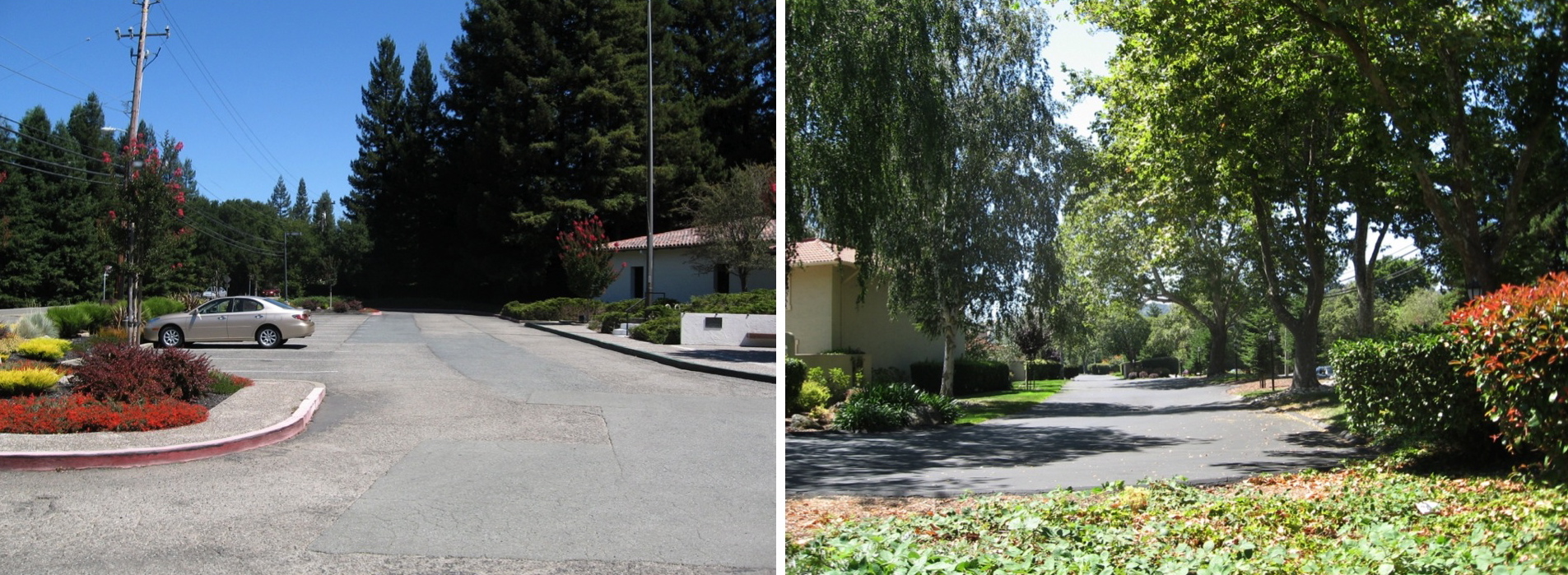
Starting at the Moraga Library driveway entrance on St. Mary's Road, facing the Moraga Historical Society and looking left or northeast, left panel, or right or southwest, right panel, you are admiring the former right-of-way of the Sacramento Northern Railroad.
L30-05-Stuart Swiedler Photos, (Image 1 of 15)

The right-of way of the SN was east of St. Mary’s Road as seen in this circa 1950s northeast view, proving today’s Lafayette-Moraga Trail between the St. Mary’s Road-Moraga Road divide and St. Mary’s College has no connection to the railroad. Moraga Road was called Jonas Hill Road at this time. Image detail.
L30-10-From the collections of the Saint Mary's College of California Archives, (Image 2 of 15)

The segment in question was primarily agricultural as seen in this northeast view, Oct. 21, 1953. This area did not get as much attention from SN photographers as Moraga station or St. Mary’s College, but several images were produced worthy of display. Image detail.
L30-15-RL Copeland Photo, from the collection of the Moraga Historical Society, Moraga, CA, 20, (Image 3 of 15)

Catching SN 654 at a halt, this southwest view circa 1950 provides a balance between hills, orchards and road to clinch the location.
L30-20-Dave Gumz Photo, Courtesy BAERA, Western Railway Museum Archives, 57494sn, (Image 4 of 15)

Not a common place for excursion stops, waiting for this planned trip featuring SN 660, a WP Open Car, and MW 302 in 1954 provides a balanced northwest view of the main features of this area and a train in motion to boot.
L30-25-Dudley Thickens Photo, Courtesy BAERA, Western Railway Museum Archives, 57493sn, (Image 5 of 15)

A four car train, full throttle, begins the curve that will ultimately reach St. Mary’s College. The pattern of vegetation on the hills and the arrangement of the catenary and utility poles is distinctive for this part of Moraga versus points to the southwest. West view from Jun. 8, 1939.
L30-30-Charles Savage Photo, Courtesy BAERA, Western Railway Museum Archives, 10124sn, (Image 6 of 15)

Same place, now July 4,1950 and MW 302 and SLU 751 lead a Bay Area Railroad Association excursion heading for the ferry Ramon, west view.
L30-32-William S. Billings Collection, Courtesy BAERA, WRM Archives, 75624sn., (Image 7 of 15)

Now eleven years ahead in time, the clues from the previous image allow placing this image of a SN 603-led freight to the east, rather than the west, of central Moraga. West view, 1950.
L30-35-Tom Gray Photo, Courtesy Tom Gray, (Image 8 of 15)

Comparing L30-35, left panel, with an image west of central Moraga that Tom Gray also took in 1950, right panel, provides further contrast of the two areas in terms of hill vegetation and the utility poles.
L30-40-Tom Gray Photos, Courtesy Tom Gray, (Image 9 of 15)

Given all that has been presented so far, this southwest image of SN 661 circa 1952 allows placement in between the St. Mary’s Road-Moraga Road divide and St. Mary’s College.
L30-45-Reginald McGovern Photo, Courtesy Reginald McGovern, (Image 10 of 15)

Two more panoramic views matching a Wil Whittaker Post Office Special passenger train shot versus one by Howard Wolfe of a tunnel maintenance train, in this one on the left, a west view from June 18, 1939, and a west view ca. 1940 on the right.
L30-46-Wilbur C. Whittaker Photo, Courtesy Arnold Menke, l, Howard T. Wolfe Photo, Courtesy BAERA, Western Railway Museum Archives, 251260sn, r, (Image 11 of 15)

And finally, northwest views of the same trains as they passed and approached St. Mary’s College.
L30-47-Courtesy BAERA, Western Railway Museum Archives, Wilbur C. Whittaker Photo, Walt Vielbaum Collection, 132856sn, l, Howard T. Wolfe Photo, 251259sn, r, (Image 12 of 15)

Finally, a four car train led by SN 1006 separates from the flank of an obscured St. Mary’s Road and begins its passage to the college station. Southwest view, circa 1940. Note the switch track is set to bring the train on the main line through the college. More on this later.
L30-50-Paul Smith Photo, Courtesy BAERA, Western Railway Museum Archives, 54017sn , (Image 13 of 15)

This west view from 1962 highlights the reconfigured St. Mary’s Road-Moraga Road divide sans railroad. The outlines of the former divide and straight path of St. Mary’s Road are still evident. These changes allowed for the construction of the Moraga Shopping Center and Moraga Commons, respectively. However, the impetus for the changes was to allow the proposed Shepherd Canyon Highway to turn along St. Mary’s Rd. For more information on that project, click here.
L30-55-Herrington-Olsen Photo, from the collection of the Moraga Historical Society, Moraga, CA, 7 D, Detail, (Image 14 of 15)

Extending the image in L30-55 to the southern end of St. Mary’s College again allows appreciation that the Lafayette-Moraga Trail did not derive from the SN right-of-way in this vicinity. Image detail.
L30-60-Herrington-Olsen Photo, from the collection of the Moraga Historical Society, Moraga, CA, 7 D, (Image 15 of 15)