Part 7 – The Take Along San Jose Avenue
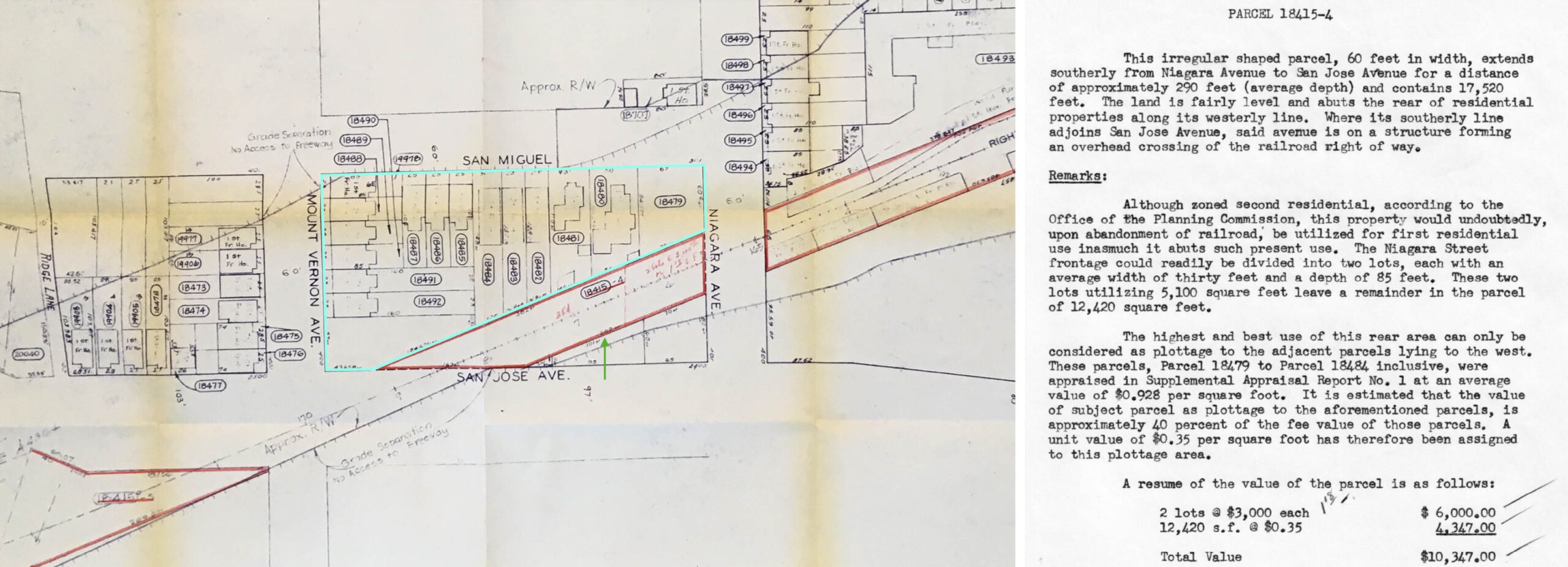
Starting where the last update concluded, Parcel 18415-4 was a short section of the active Southern Pacific, SP, San Bruno Branch extending from Niagara Ave. to the underpass of San Jose and Mt. Vernon Aves., green arrow in the left panel, with houses on the northern flank to be razed as well, turquoise enclosure. Note the right-of-way would form the southern boundary of the Highway 280. A description of the section is described in the right panel ca. 1957.
L285-05-Copyright California Department of Transportation, Folder 1197, (Image 1 of 41)

A southwest aerial view of the area from Mar. 31, 1953 is shown on the left, from which the detail on the right has been extracted. The orange arrow points to a small cap-like structure on the northeastern-most house on Mt. Vernon Ave., Parcel 18492, that will serve as a marker in subsequent images.
L285-10-Copyright California Department of Transportation, 3326-14, (Image 2 of 41)
Description, as written in the District IV report, ca. 1956-1957: Southwesterly view across Niagara Ave. showing subject parcel. Fence at left encroaches on parcel. Note the second portal of the SP underpass that had been used in earlier years.
L285-15-Copyright California Department of Transportation, Folder 1197, (Image 3 of 41)
Description: Rear of Parcels on San Miguel St. This southeast view toward Mt. Davidson and Miraloma in the distance was taken on the San Jose Ave. overpass of the SP looking toward Niagara Ave. and San Francisco Glass Co.
L285-20-Copyright California Department of Transportation, Folder 1149, (Image 5 of 41)
Description: Rear of Parcels on Mt. Vernon and San Miguel. This west view shows buildings along Mt. Vernon Ave. from the center to the left border, and those to the right of center along San Miguel St.
L285-25-Copyright California Department of Transportation, Folder 1149, (Image 6 of 41)
Before moving on to SP-related Parcel 18415-5 that began on the southwest side of the San Jose Ave. overpass of the railroad, the houses along the northwest flank of the railroad will be covered. A southwest aerial view of the area from Mar. 31, 1953 is shown on the left, from which the detail on the right has been taken to guide this discussion.
L285-30-Copyright California Department of Transportation, 3326-14, (Image 7 of 41)
The houses marked by colors will be shown in the images to follow. Rear views of those marked by the purple lines have already been shown in L285-25, but the images to follow will show the frontages of these properties.
L285-35-Copyright California Department of Transportation, Folder 1153, (Image 8 of 41)
Description, left: Looking east on Mt. Vernon. Description, right: North side Mt. Vernon from San Jose Ave. Basically, two views in both directions on Mt. Vernon Ave. The orange arrow points to the marker designated previously, a small cap-like structure on the northeastern-most house on Mt. Vernon Ave., Parcel 18492. Note in the left panel how the street is cut off by the SP overpass at San Jose Ave.
L285-40-Copyright California Department of Transportation, Folder 1149, (Image 9 of 41)
Description, left: East side San Miguel from Niagara. Description, right: South side Mt. Vernon from San Jose Ave. The left panel shows the houses corresponding to Parcels 18479-87 in L285-35, while the right panel shows the houses corresponding to Parcels 18473-78 in L285-35. Note the street signs in both images.
L285-45-Copyright California Department of Transportation, Folder 1149, (Image 10 of 41)
Next, to the empty lot with billboard and houses along the west side of San Jose Ave., overlooking the SP right-of-way, and described on the left. Description, right: Parcels 18468-72.
L285-50-Copyright California Department of Transportation, Folder 1153, (Image 11 of 41)
The appraisal of the empty corner lot, Parcel 18472, is on the left. Description, right: View from rear of parcel looking west toward San Jose Ave.
L285-55-Copyright California Department of Transportation, Folder 1153, (Image 12 of 41)
Heading southwest, the next portion of the SP active railroad line was Parcel 18415-5. Note the double-track section that served the local area as a team track.
L285-60-Copyright California Department of Transportation, Folder 1197, (Image 13 of 41)
The full description of Parcel 18415-5 is shown on these three panels, and continues to the next frame. Note the mention of the team track in the right panel, red underline.
L285-65-Copyright California Department of Transportation, Folder 1197, (Image 14 of 41)
The valuation of the entire parcel is presented in the left and center panels, while the leasing agreements for railroad land are described in the far right panel.
L285-70-Copyright California Department of Transportation, Folder 1197, (Image 15 of 41)
Description: Northeasterly view taken approximately 250 feet westerly of Ottawa St. showing area which could readily be divided into ten building sites. Starting with this image with four more to follow, Parcel 18415-5 will be reviewed ca. 1957 east to west.
L285-75-Copyright California Department of Transportation, Folder 1197, (Image 16 of 41)
Description: Easterly view taken approximately 500 feet westerly of Ottawa St. showing topography of land lying southerly of center line of railroad track.
L285-80-Copyright California Department of Transportation, Folder 1197, (Image 17 of 41)
Description: Westerly view taken approximately 500 feet westerly of Ottawa St. showing typical area northerly of tracks.
L285-85-Copyright California Department of Transportation, Folder 1197, (Image 18 of 41)
Description: Easterly view taken approximately 200 feet easterly of Sickles Ave. Note paved area. A portion of fencing in the distance is on railroad right-of-way and is on land leased to H. Plath and Sons.
L285-90-Copyright California Department of Transportation, Folder 1197, (Image 19 of 41)
Description: Easterly view across intersection of San Jose and Sickles Aves., showing corner which is zoned for commercial use.
L285-95-Copyright California Department of Transportation, Folder 1197, (Image 20 of 41)
Two maps from District IV from 1956 will begin a review of the properties to be taken on the north side of the tracks from Naglee Ave. extending to the west. The red arrow points to Parcel 18466 in both maps, a starting point after a brief introduction.
L285-100-Copyright California Department of Transportation, Folder 1183, left, 1197 right, (Image 21 of 41)
Next, to look at lots and houses overlooking the SP right-of-way ca. 1957.
L285-105-Copyright California Department of Transportation, Folder 1183, (Image 22 of 41)
The two lots bordering the Naglee to Whipple Aves. interval will be examined in detail.
L285-110-Copyright California Department of Transportation, Folder 1183, (Image 23 of 41)
First, Parcel 18466, northwest view.
L285-115-Copyright California Department of Transportation, Folder 1183, (Image 24 of 41)
Next, a sweeping southeast panorama showing city-owned Parcel 18463 with billboards.
L285-120-Copyright California Department of Transportation, Folder 1183, (Image 25 of 41)
A northwest panorama of the whole set of structures is shown here …
L285-125-Copyright California Department of Transportation, Folder 1183, (Image 26 of 41)
… followed by this complementary southeast panorama.
L285-130-Copyright California Department of Transportation, Folder 1183, (Image 27 of 41)
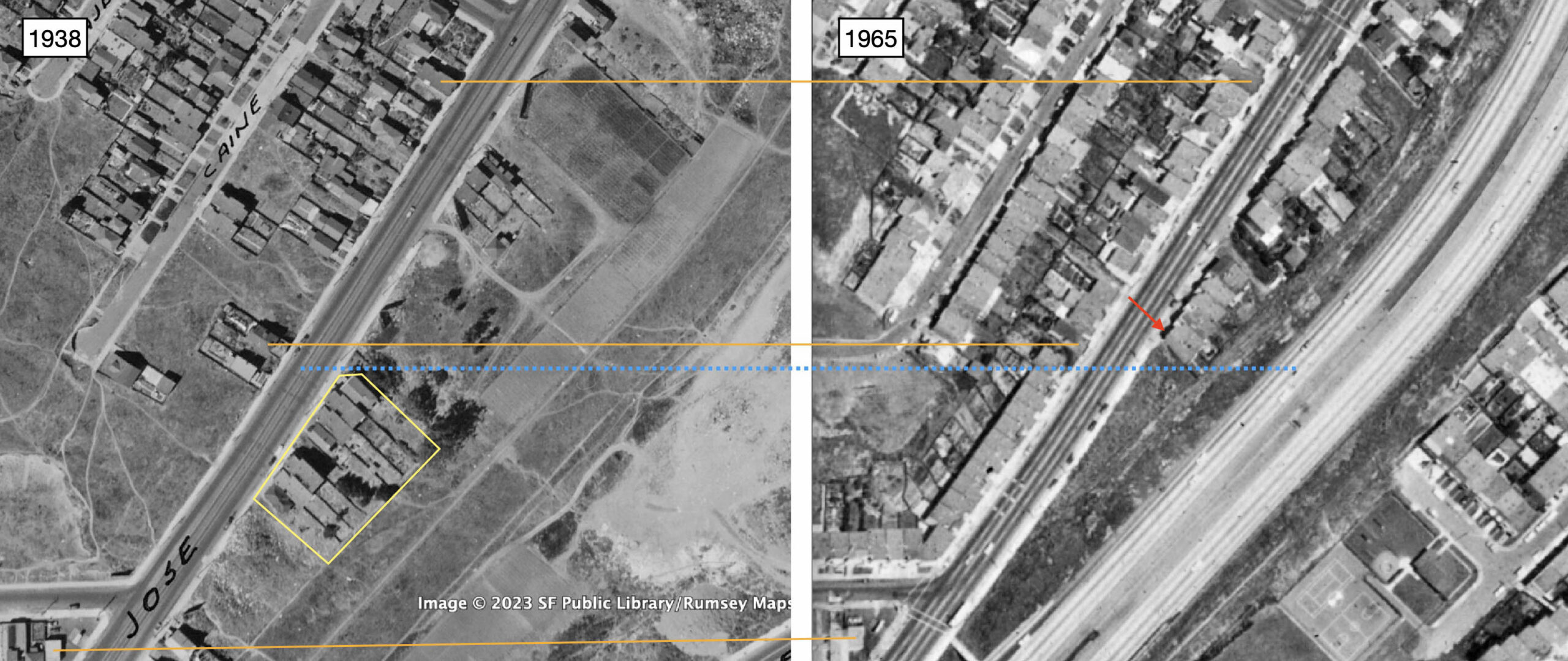
Property lines were adhered to for the construction of Highway 280, shown in a comparison of pre- versus post-construction north-oriented aerials from 1938 and 1965. Orange lines connect house present in both images as a way to line them up, the blue broken line shows where the demarcation of land to be taken was made, and the structures just reviewed that were to be razed are boxed in by the yellow line. The red arrow points to 2661 San Jose Ave., still standing in 2023.
L285-135-Courtesy Google Earth and cas-65-130_10-15, Courtesy of UCSB Library Geospatial Collection, (Image 28 of 41)
To get the complete story, however, the southwest view from Mar. 31, 1953, left, and the west view from 2023 are needed. The house at no. 2661 San Jose Ave. is again marked by a red arrow. Absent in 1938, shown in the previous entry, that house as well as ones to the southwest, yellow box, were built by 1953. The houses in the yellow box were gone in 1965, shown in the previous entry as a result of the highway construction, but in the early 1970s they were partially replaced, still standing in 2023, again outlined in yellow. This is an example where the State resold lots that they had taken by eminent domain, but did not fully use.
L285-137-Copyright California Department of Transportation, 3326-13, left, and Google Maps, right, (Image 29 of 41)
Next to the western section of SP Parcel 18415-5, here showing a diagrammatic representation of the team track ca. 1957.
L285-140-Copyright California Department of Transportation, Folder 1197, (Image 30 of 41)
In terms of structures, moving further to the southwest from Parcel 18463, the next set of structures above or north of the west section of SP parcel 18415-5 to be taken by eminent domain are shown. Note again how no houses south of the tracks were to be included from the overpass of the SP until one block east of Sickles Ave.
L285-145-Copyright California Department of Transportation, Folder 1197, (Image 31 of 41)
Presented here are the details of the properties to be discussed from the District IV valuation “Supplemental Report No. 38, May 29, 1957 Prepared by W. W. Hitchcock.” The text within the black box in the left panel actually follows after the end of the text in the right panel.
L285-150-Copyright California Department of Transportation, Folder 1190, (Image 32 of 41)
As already shown in an earlier update, lots of billboards were present where the railroad crossed San Jose and Sickles Aves.
L285-155-Copyright California Department of Transportation, Folder 1190, (Image 33 of 41)
The walk begins on the south side of San Jose Ave. at Farallones St., the first house off the corner next to the empty lot with billboard, Parcel 18461, is displayed here. The front, center panel, and rear, right panel, views are seen here, the details shown next. Return to L285-145 to view the starting point if that is not clear.
L285-160-Copyright California Department of Transportation, Folder 1190, (Image 34 of 41)
All the details for Parcel 18461 are provided here. An added bonus, and very rare to see in a District IV report, are parcel diary notes, pasted here on top of the rental schedule, center panel. They provide much insight into the reaction and behavior of property owners to the eminent domain process. More to come.
L285-165-Copyright California Department of Transportation, Folder 1190, (Image 35 of 41)
The walk continues on the south side of San Jose Ave., the last house before Broad St. is Parcel 18449, the front, left panel, and rear, right panel, views shown here. To the west is an empty lot with a billboard.
L285-170-Copyright California Department of Transportation, Folder 1190, (Image 36 of 41)
All the details for Parcel 18449 are provided here with another illuminating parcel diary.
L285-175-Copyright California Department of Transportation, Folder 1190, (Image 37 of 41)
Further west and up against another billboard is Parcel 18432, the front, left panel, and rear, right panel, views shown here.
L285-180-Copyright California Department of Transportation, Folder 1190, (Image 38 of 41)
All the details for Parcel 18432 are provided here, with a parcel diary that is unusually candid.
L285-185-Copyright California Department of Transportation, Folder 1190, (Image 39 of 41)
Crossing San Jose Ave., walking one block west to Sadowa St., making a right turn on Sadowa St., and turning around to look back at the south side of San Jose Ave. reveals the parcels as marked and another billboard. At this point, the SP right-of-way and houses are at the same elevation.
L285-190-Copyright California Department of Transportation, Folder 1153, (Image 40 of 41)
Separated by the SP team track by the wooden fence is the last parcel to be presented in detail in this update, Parcel 18447. Next time, some great ground views at the SP crossing of San Jose Ave. Appreciation to the San Francisco Planning Dept. and Preservation Planner Melanie Bishop for making the District IV files available.
L285-195-Copyright California Department of Transportation, Folder 1153, (Image 41 of 41)