Railway Battle for Berkeley – Introduction
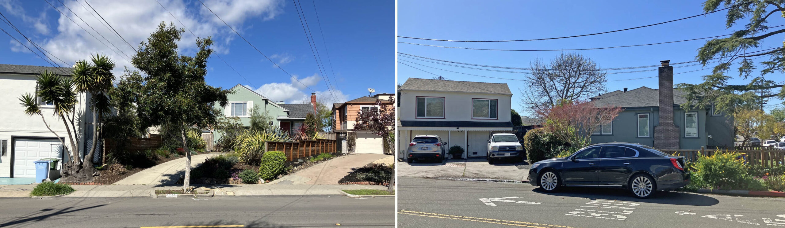
A north view from California St. at Rose St. in Berkeley in 2026 reveals a railing over a previous street underpass seen toward the left edge, and an offset continuation of California St. to the north, seen toward the right edge.
L343-02-Stuart Swiedler Photos, (Image 1 of 38)

A left turn and walk down Rose St. toward the end of the block reveals houses on the north side set at an angle to the street, left, that can be followed to California St. just short of Ada St. on the west side, right.
L343-05-Stuart Swiedler Photos, (Image 2 of 38)
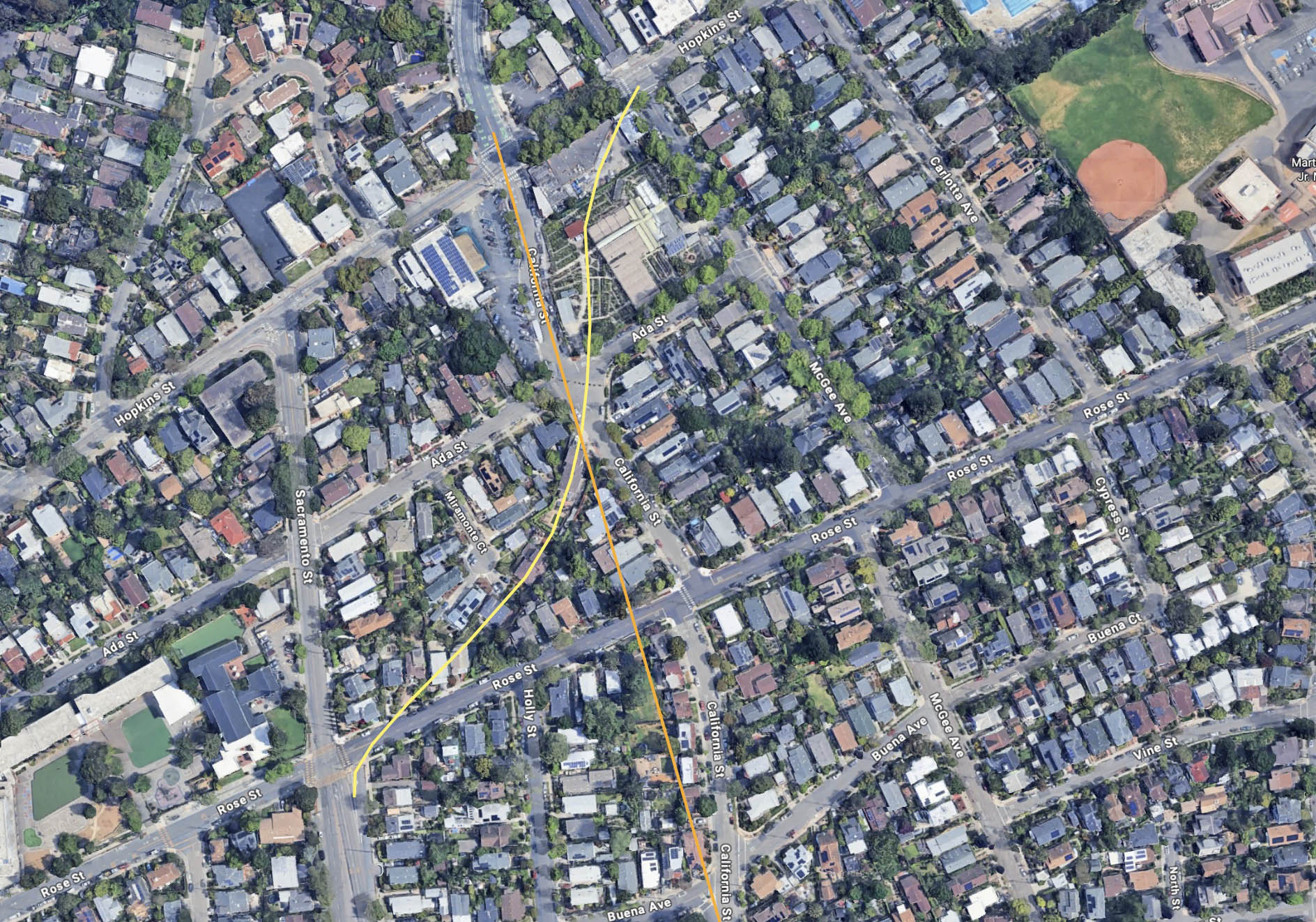
A north-oriented aerial view from 2026 reveals other telltale signs of two former right-of-ways crossing each other through the area. First, one path as straight as an arrow, orange line, coming off California St. at Buena Ave. onto a private right-of-way from the south, and splitting the intersection of Hopkins St. and Monterey Ave. from the north. The other a large reverse curve coming off a turning lane of Sacramento St. from the south, across Rose St., and then onto a private right-of-way until exiting on Hopkins St. just west of McGee Ave.
L343-10-Courtesy Google Maps, (Image 3 of 38)
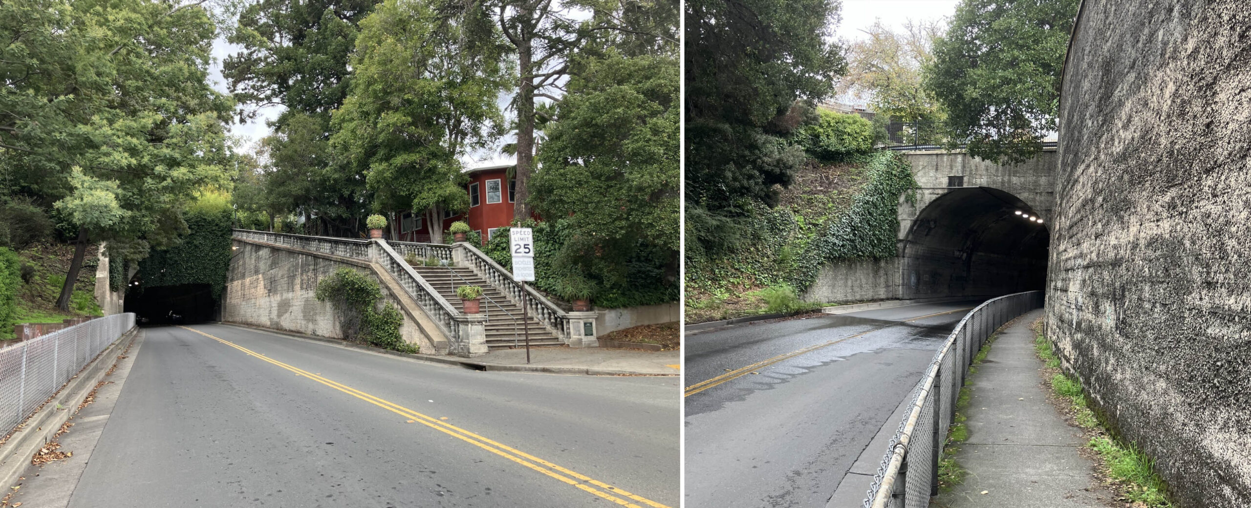
Meanwhile, to the northeast, the portal of a tunnel now used to funnel auto traffic from Sutter St., left, north view, to Solano Ave., right, southeast view, the latter portal with the date stamped 1910. All the images shown so far are the remnants of an intense battle that took place between the Key System, Key, and its Key Route or interurbans, versus the Southern Pacific, SP, or suburban lines in the first half of the 20th century. To avoid confusion, all electric railway lines in this update will be referred to as “railways”.
L343-15-Stuart Swiedler Photos, (Image 4 of 38)
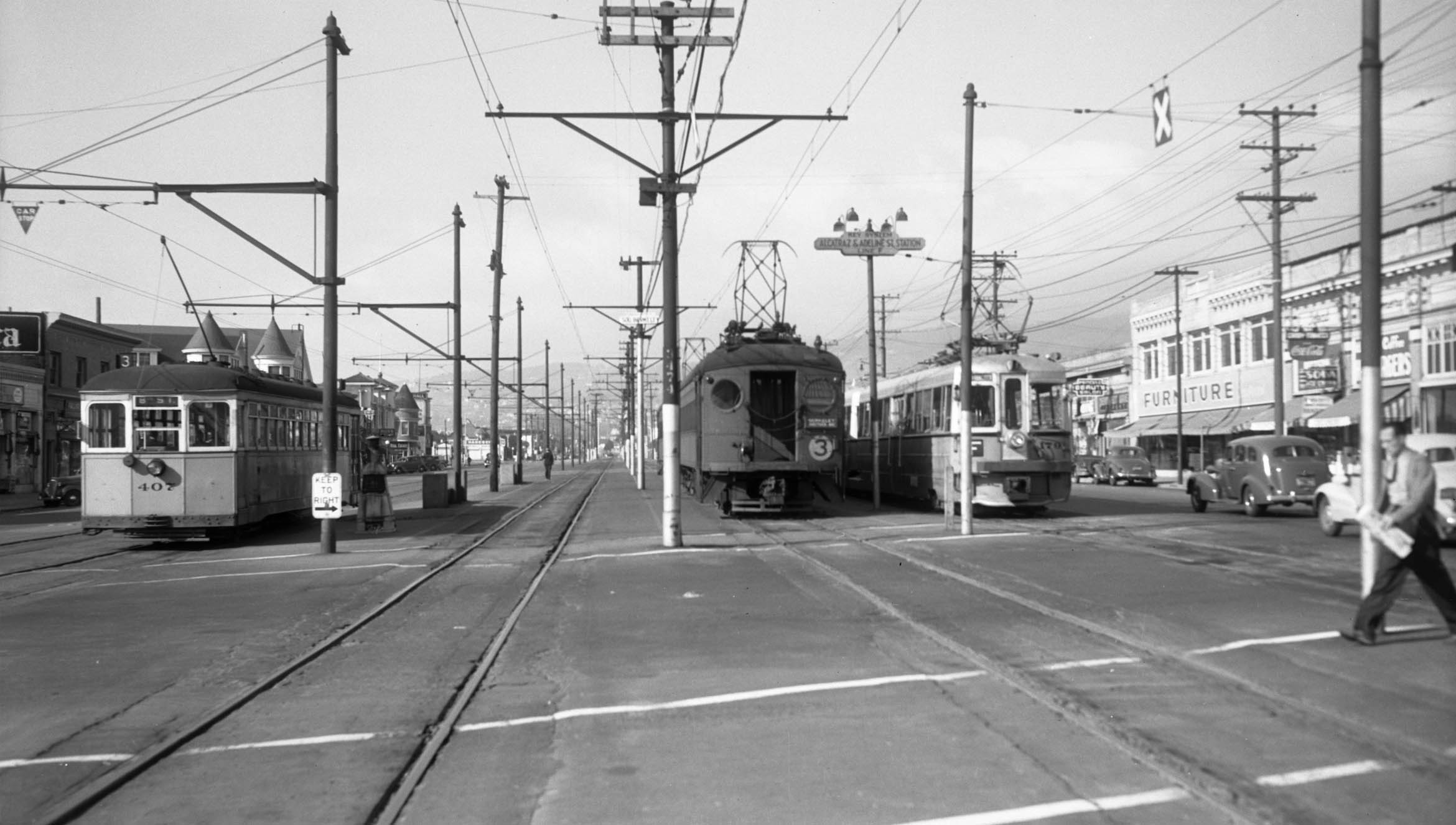
Before US entry into WWII in Dec. 1941, the war between the Key and SP was about to end at mid-year. Here at Adeline St. and Alcatraz Ave. in a north view, the East Bay Street Railway Grove St. no. 3 streetcar and Key System Shattuck Ave. F line railway box in an Interurban Electric Railway, IER, Shattuck local no. 3 train. The IER name was given by the SP in 1939 to their electric lines to designate them as a distinct business from their steam lines, and to indicate the trains as true interurbans when they started to use the Bay Bridge.
L343-20-Roy Covert Photo, Courtesy BAERA, Western Railway Museum Arechives, 54080ks, (Image 5 of 38)
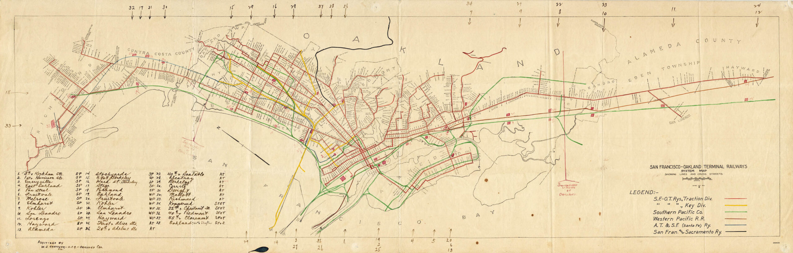
Back further in time to a East Bay traction map dated Apr. 6, 1916, the battle was raging on by multiple players as listed. Appreciate that all of this activity was financed by private money save for times when the government intervened, usually at wartime, or for construction projects such as the Bay Bridge that impacted line operations. For accuracy, the black line is labeled the San Fran and Sacramento Ry., a term not applicable until 1920. The correct designation is Oakland, Antioch and Eastern Railway in 1916, later the Sacramento Northern Railway starting in 1929.
L343-25-Courtesy Port of Oakland, (Image 6 of 38)
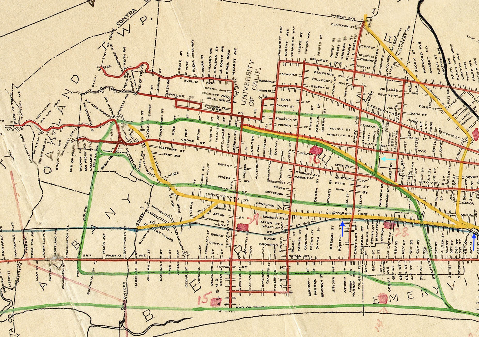
A detail of the previous map rotated so that north is toward the left edge shows where the railway battles, green versus yellow lines, were most contentious, mostly in Berkeley where the next set of presentations will focus. What is known about the SP Ellsworth line, turquoise arrow, has been covered in another update, click here. The Key railway line along Lowell St. within the borders of the two blue arrows has been covered elsewhere, click here, but some additional photos will be added as needed in the next update, particularly on its construction.
L343-30-Courtesy Port of Oakland, (Image 7 of 38)
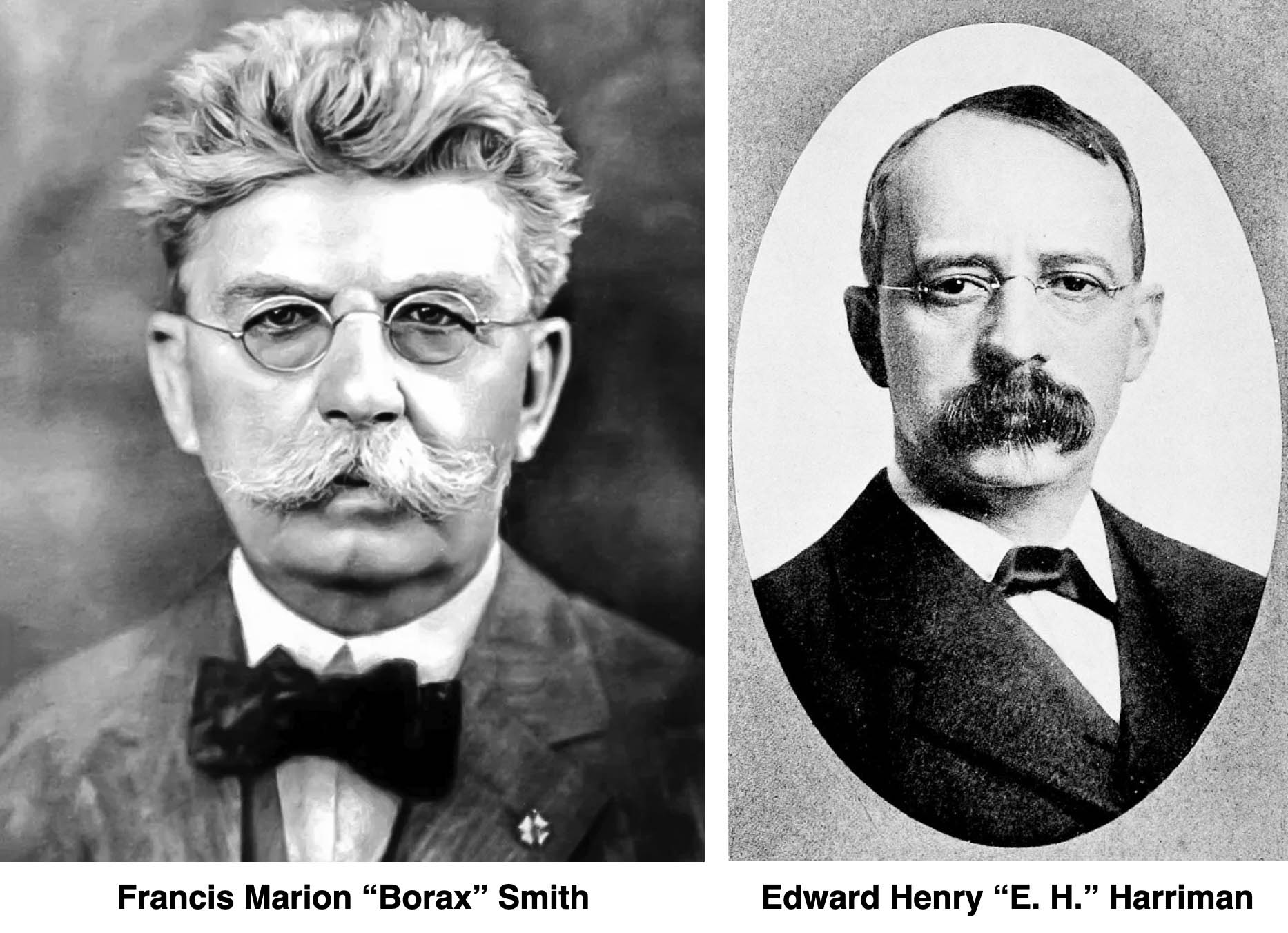
The two men behind the genesis of the railway battles were Marion “Borax” Smith and E. H. Harriman, one a Wisconsin farm boy, and one a Wall Street errand boy, respectively. They both had a vision for how to best establish an efficient transportation system in the Bay Area and preferred to do so as a monopoly. First to start with Smith, general information about him was derived from Harry Demoros’ ”The Key Route”, Interurban Press, 1985, Vernon Sappers’ “Key System Streetcars”, Signature Press, 2007, and Erle Hanson’s “California & Nevada Railroad”, R&S printers, 1988.
L343-35-Courtesy BAERA, Western Railway Museum Archives, l, Wikimedia Commons, r, (Image 8 of 38)
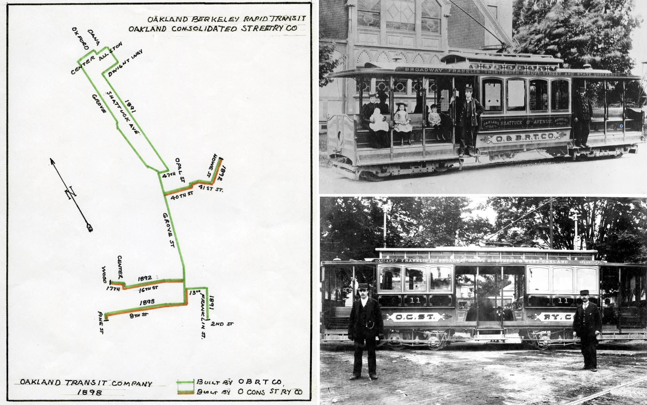
Borax Smith settled in Oakland in 1881 having amassed a fortune in the Pacific Coast Borax Co. He developed land in the East Bay via a combination of real estate investment and transportation. He made three important overall decisions in relation to this goal. First, it was streetcars. Electric streetcars came to the East Bay in 1891 as seen on this map, left. He bought into the Oakland Consolidated Streetcar Co. in 1893, that company the successor to the cars seen in the upper right. Between this date and 1902, he would acquire 10 more lines at bargain prices, and consolidate them to eliminate all competitors. By 1906, the incorporated name was the Oakland Traction Co.
L343-40-Courtesy BAERA, Western Railway Museum Archives, Bradas Collection, 71676ks, top l, Hanson Collection, 130092ks, bottom l, (Image 9 of 38)
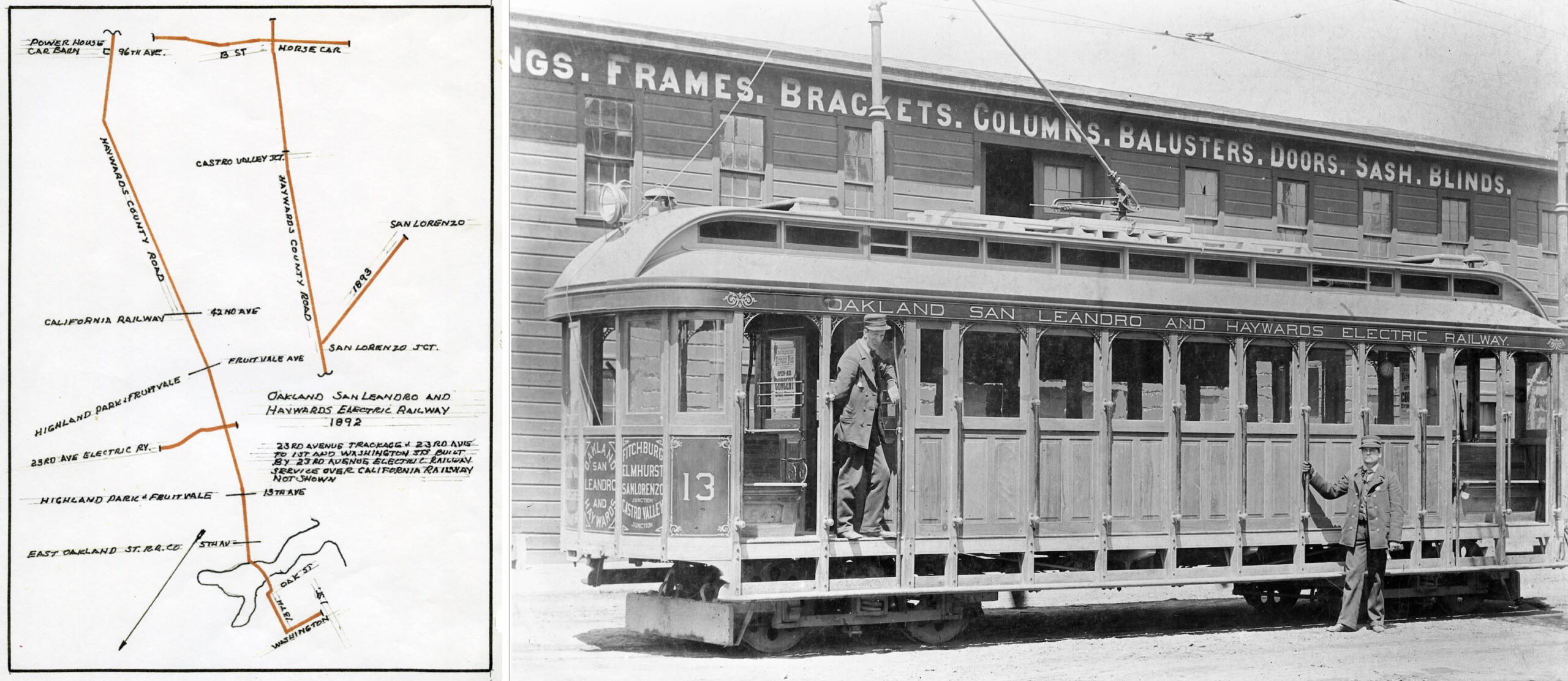
The second decision had to do with realizing the potential to create an interurban electric train system that would link the East Bay, San Jose and San Francisco. He saw a path to San Jose in the Oakland, San Leandro, and Haywards Electric Railway seen in the map, left, and streetcar image, right. In 1901, he took advantage of this streetcars’ financial problems, and purchased the line for his growing traction business. He would now need a more direct way to connect to San Francisco, and that meant building a ferry terminal into the Bay.
L343-45-Moreau Collection, Courtesy BAERA, Western Railway Museum Archives, 84225ks, (Image 10 of 38)
Demoro notes that Smith had acquired the California and Nevada Railroad, C&N, a steam-powered, narrow gauge line that started in Emeryville and extended for 22 plus miles to near what is today Orinda BART to create a new entity, the Oakland, San Francisco and Terminal Co. of 1893. Hanson provides more direct evidence that he only made an agreement with the C&N. The railroad entity itself was a a failed venture, ceasing to operate after 1900. It didn’t quite fit the rapid electric interurban model, however, the right-of way provided value.
L343-50-Erle Hanson Collection, Courtesy BAERA, Western Railway Museum Archives, (Image 11 of 38)
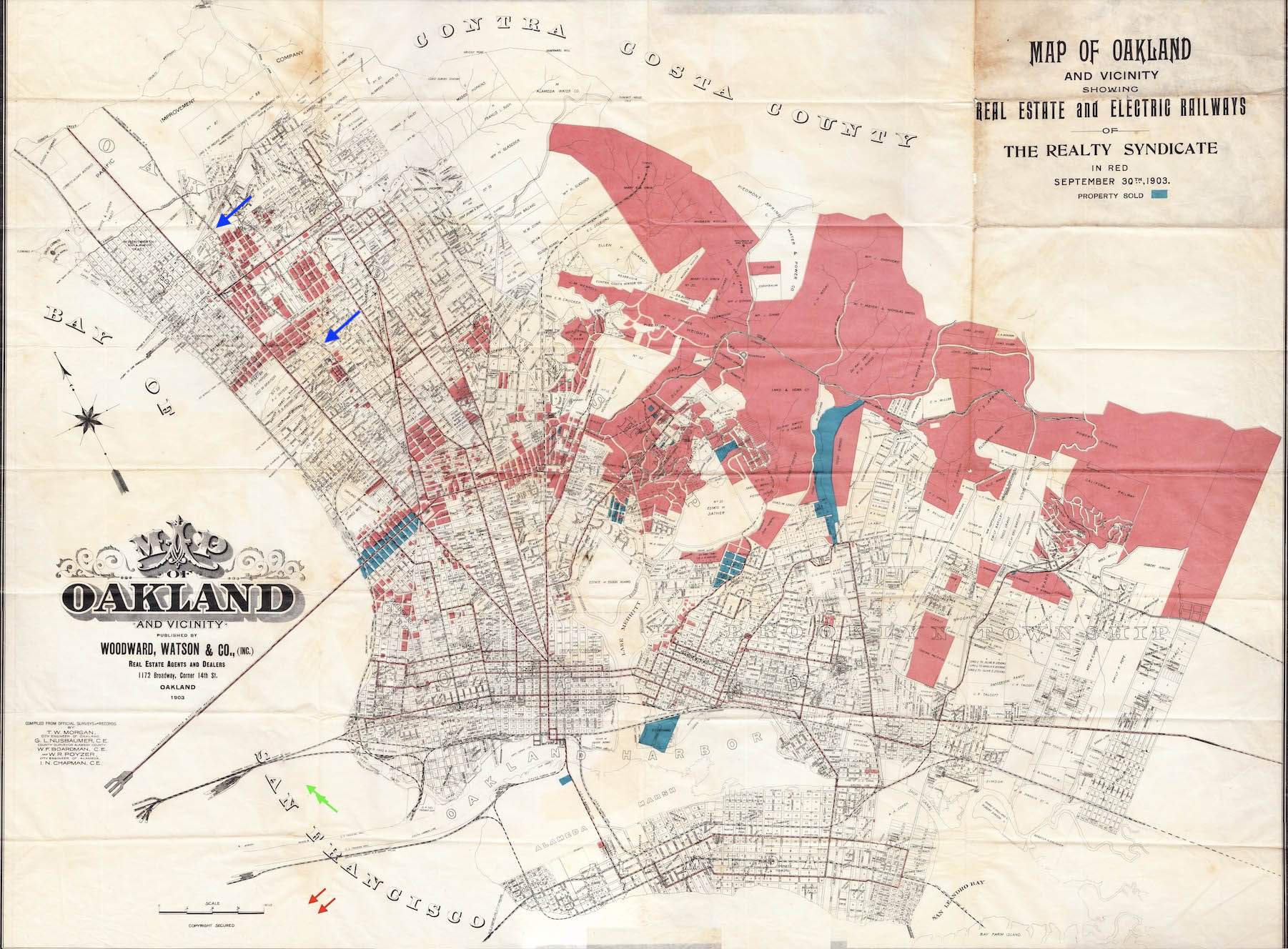
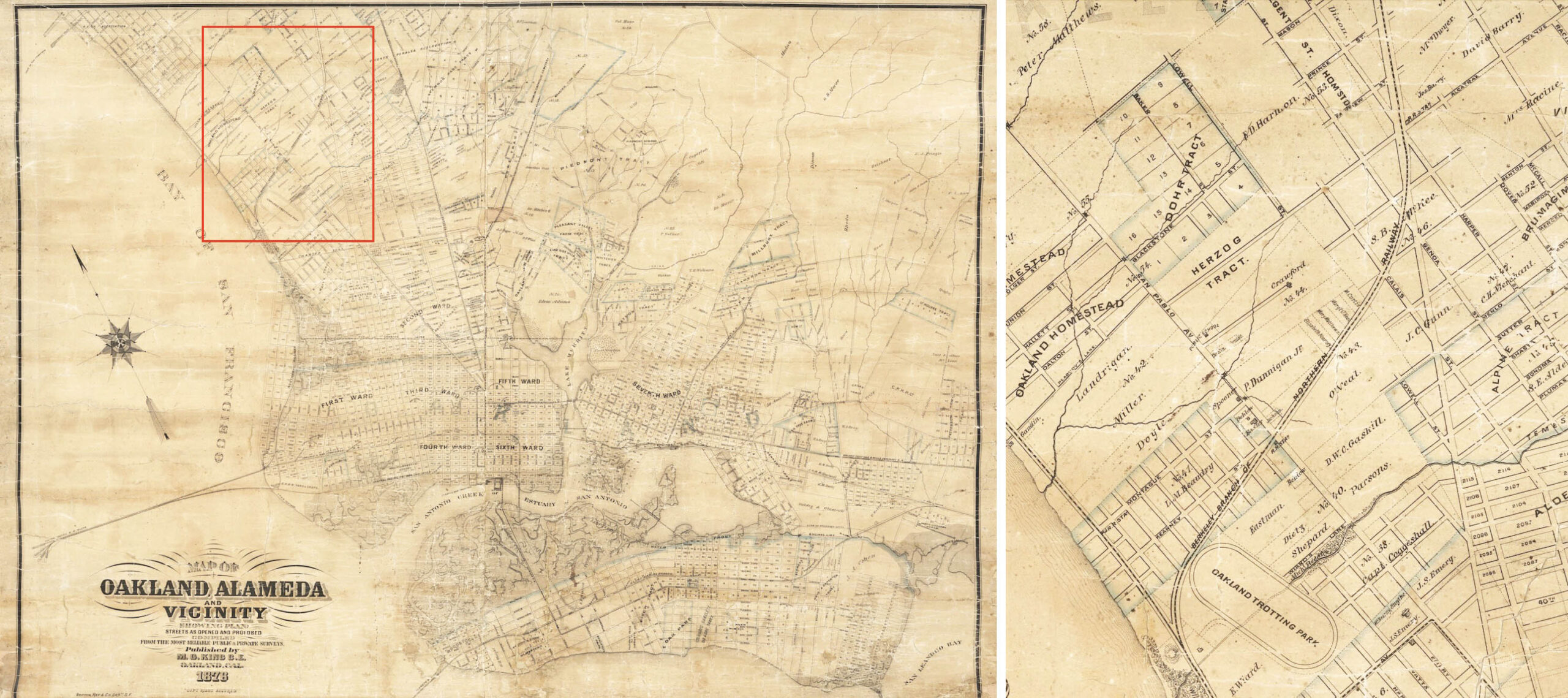
His third decision was to form the Realty Syndicate Co. with Frank Havens in 1895. This map from 1903 shows their holdings as of that year, the initial purchase being 13,000 acres in the East Bay hills. Very little of the holdings were in Berkeley, except along the C&N, blue rows, and, unknown at the time, properties that clustered around the future Key Northbrae and SP California railway lines.
L343-55-Map of Oakland and Vicinity, Published by Woodson, Watson and Co., Courtesy John Bosko, (Image 12 of 38)
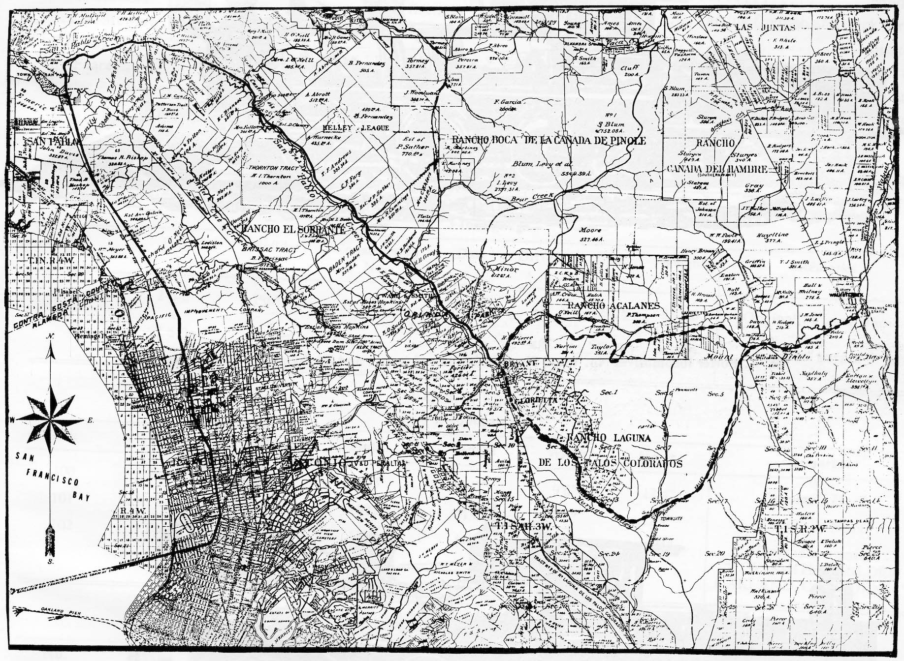
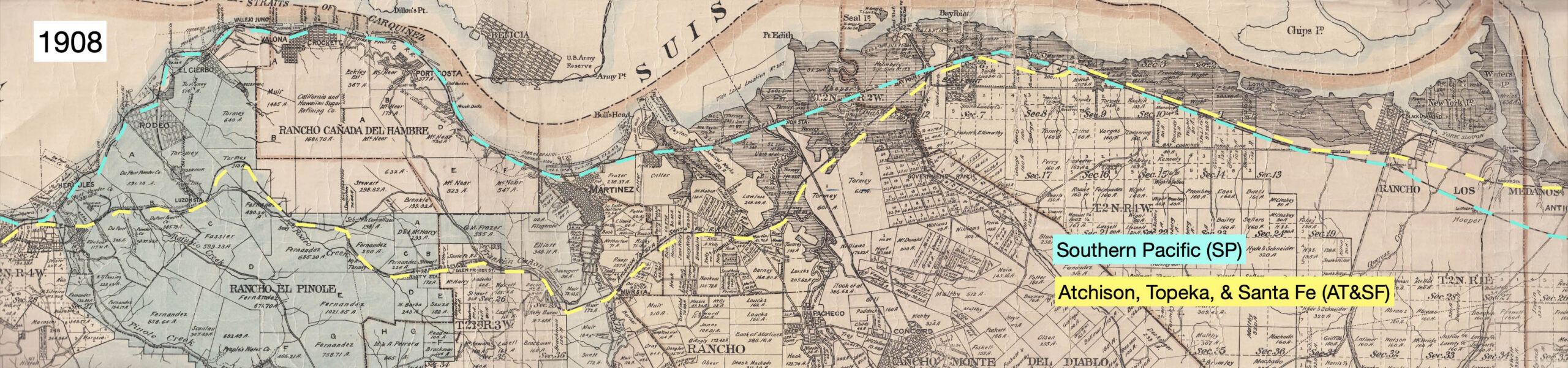
Through the Realty Syndicate, Smith and Havens turned their attention to a transcontinental competitor of the SP entering the East Bay, the Atchison, Topeka & Santa Fe Railroad, SF. The SF followed the SP across Contra Costa County as shown on this map. After a stop in Richmond, trains continued to a ferry terminal in Port Richmond. The first train from Chicago arrived in 1900, but the SF wanted a way into Oakland and operate a ferry pier. However, the SP blocked the path into Oakland primarily by justifying their claim to waterfront land that the SF would need to access.
L343-60-Courtesy Earth Sciences and Map Library, University of California, Berkeley, G4363.C6 1908.M3, (Image 13 of 38)
A northeast view of the SF Point Richmond ferry terminal in 1922 brings us to the solution to their entrance to Oakland and getting passengers to San Francisco. According to Hanson, the Syndicate acquired a property they needed on Adeline St. on Mar. 5, 1902, and the next day the C&N property in Emeryville, together giving Smith access to the coast and C&N wharf into the Bay. He then dealt the rest to the SF with the adjacent yard to the west of San Pablo Ave. Within two days, Oakland and Berkeley awarded the SF franchise to enter.
L343-65-Moreau Collection, Courtesy BAERA, Western Railway Museum Archives, (Image 14 of 38)
A company created only on paper called the the Oakland and East Side Railroad obtained the previously foreclosed C&N for the SF, all 250 miles of proposed right-of-way on Mar. 17, 1903. The SF would arrive in Oakland in 1904 to their new depot as shown, and by that time Smith was ready to take San Francisco-bound passengers to their ferry terminal, or inland to downtown Oakland or Berkeley. Demoro notes that Smith gave away a passage of his new railway routes on Adeline St. by the deal made with the SF, but Emeryville was never going to let that street have anything more than a single track, as it remained until the SF last freight in 1979.
L343-70-Sappers Collection, Courtesy BAERA, Western Railway Museum Archives, 21405atsf, (Image 15 of 38)
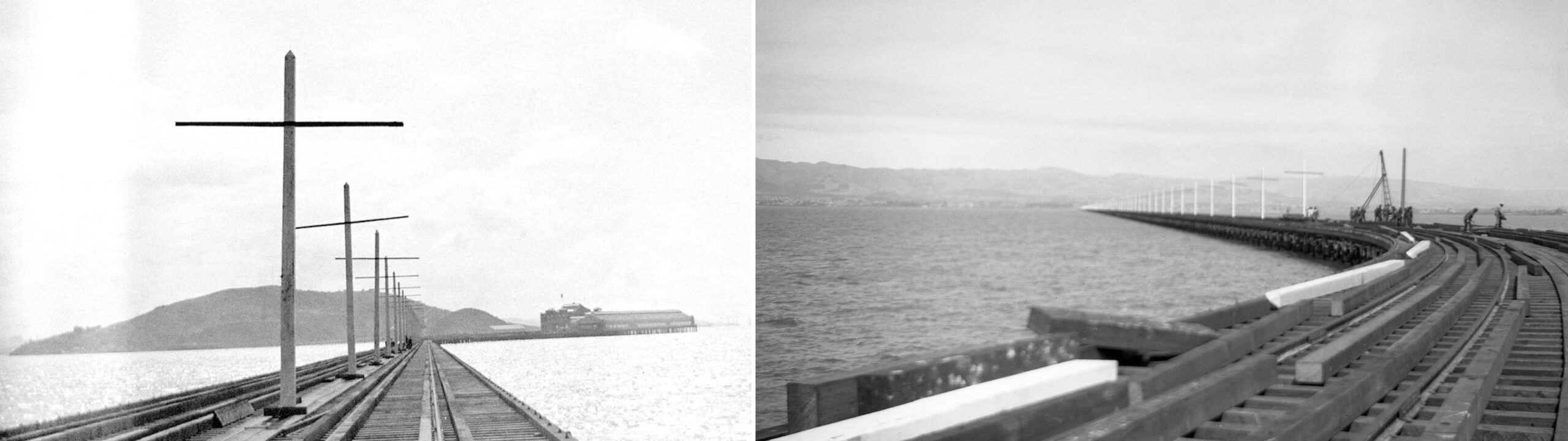
Demoro notes that the operating company of the Key Route, the San Francisco, Oakland, and San Jose Railway, SFO&SJR, was incorporated in June 1902. It took only 15 months or so to complete the pier and ferry terminal. The west view from Oakland, left, and east view from the ferry terminal, right, from June 1903 show the poles to hold the overhead wire being added along the trestle. The trestle appears to be an extremely long extension into the Bay, and Smith intended it that way.
L343-75-Key Official Photos, Robert L. Stein Collection, Courtesy BAERA, Western Railway Museum Archives, 154535ks, l, 154533ks, r, (Image 16 of 38)
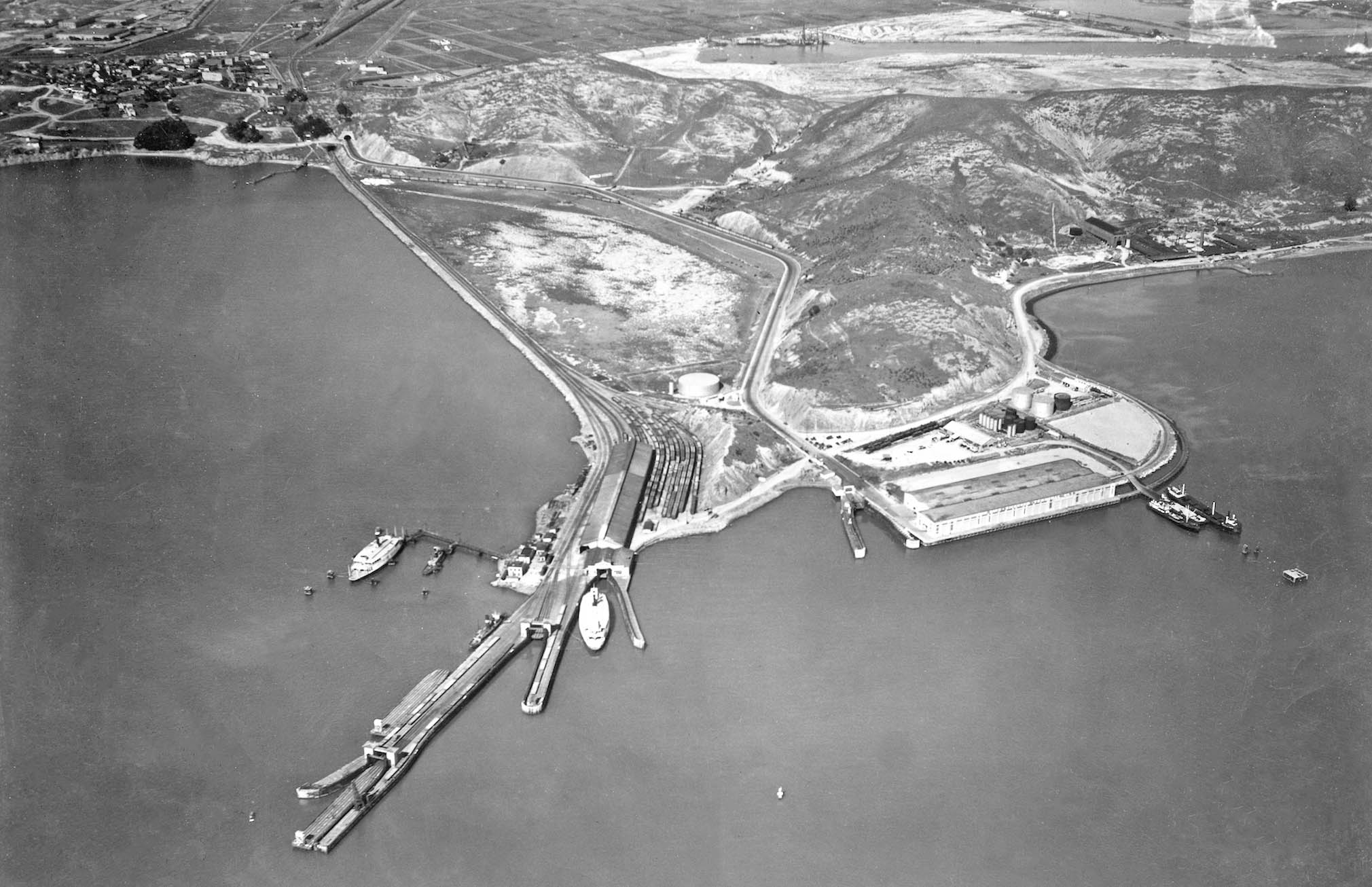
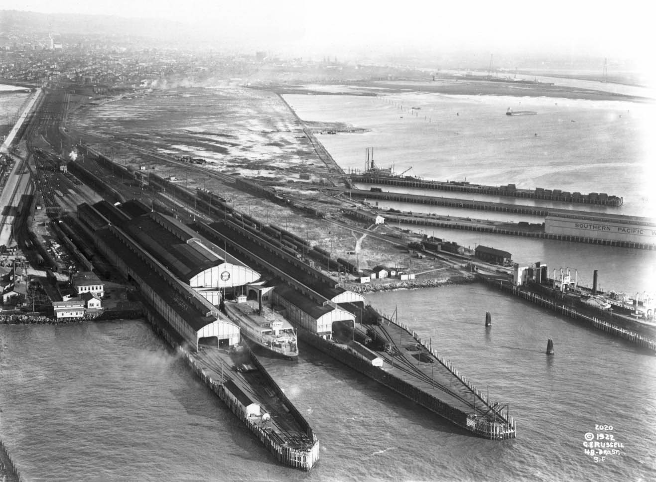
The east view shown here was taken in the 1920s, after the trestle had been remade and widened to add more tracks. The red arrow marks where the original straight trestle had been located, the remaining stub being used to store cars at this date. What is clear from this image is that Smith wanted the shortest possible ride on a ferry versus his fast electric trains. In terms of the distance to the San Francisco Ferry Building, the Key ferry terminal was 2.85 miles versus 3.5 miles for the SP Oakland Pier.
L343-77-George Russell Photo, Courtesy the California State Lands Commission, API 650_5_Box 920, (Image 17 of 38)
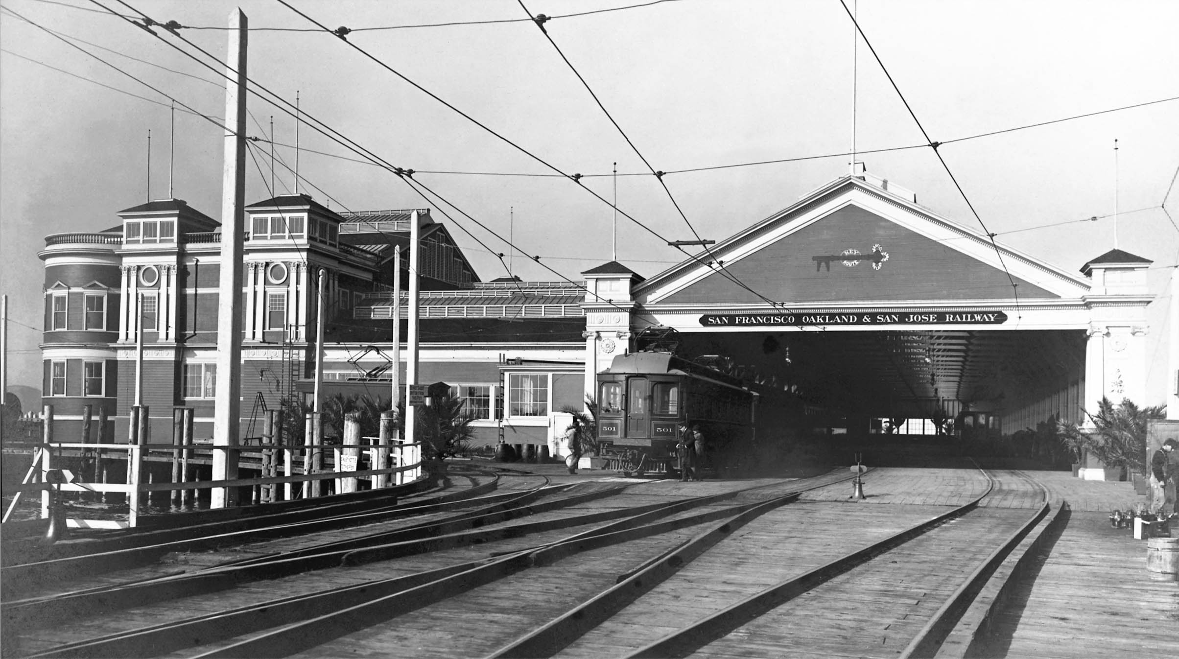
Finally, opening day for the SFO&SJR, Oct. 26, 1903, with a five-car train led by car 501 at the pier ready to head to Berkeley on tracks laid down alongside the SP Shattuck line just at the city’s southern-most border, where Stanford Ave., route of the SP, joined Adeline St., route of the Key. In total, the Key line was more than two miles shorter than the SP line from Shattuck and University to the Ferry Building, and a cheaper, cleaner, and faster ride. Plus, as Demoro notes, the initial 500 series cars “tended to reflect standards and elegance found on steam railroads.” Next, the response by the SP.
L343-80-Sappers Collection, Courtesy BAERA, Western Railway Museum Archives, 28948ks, (Image 18 of 38)
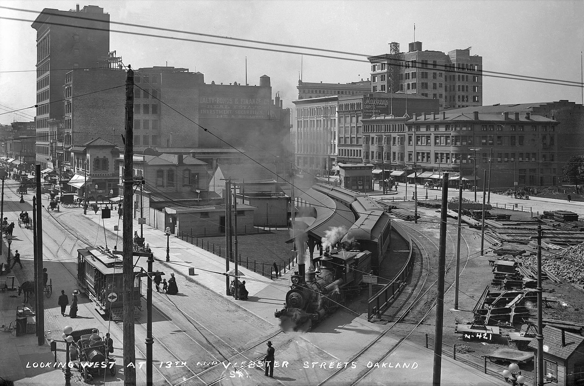
This 1911 northwest view toward the corner of Webster St. and 13th St. in Oakland shows a narrow gauge SP steam engine with four passenger cars at the 14th St. SP station. The Oakland Traction Co. streetcar sits nearby. To the trains right or west flank the beginning of the conversion to an overhead electric railway above the standard gauge tracks can be seen. It took the SP almost 8 years after the Key’s initial railway debut to convert to electric trains, and most of the information in this section about electrification was derived from Robert Ford’s “Red Trains in the East Bay” Interurbans Publications, 1977 unless otherwise noted.
L343-85-Sappers Collection, Courtesy BAERA, Western Railway Museum Archives, 25432ks, (Image 19 of 38)
This map and detail from 1876, two years prior to the city of Berkeley’s incorporation, document that a steam train began service that year along Adeline St. and Shattuck Ave. The Berkeley Branch Railroad, a subsidiary of the Central Pacific Railroad, CP, branched at Shellmound from the CP subsidiary Northern Railway line, eventually terminating at Shattuck and University Aves., later extended north in 1878 to Vine St. or Berryman’s Station. It would later be extended south to the Oakland Pier. Like other CP-owned subsidiaries, it would be leased to the SP in 1885, and merged into the latter in 1898.
L343-90-Map of Oakland, Alameda and Vicinity, Published by M.G. King C.E., Courtesy David Rumsey Map Collection, David Rumsey Map Center, Stanford Libraries, (Image 20 of 38)
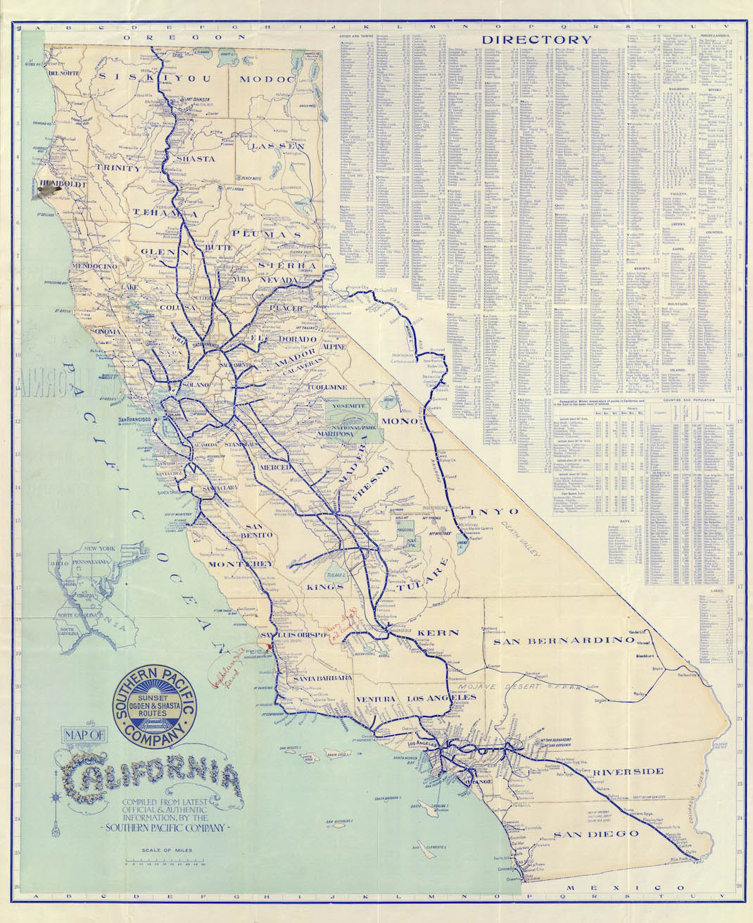
E. H. Harriman became famous for reviving financially distressed railroads, and became President of the SP in 1901, and the Union Pacific in 1903. As with this map from 1901, writer Frank Norris likened the SP to an octopus, using its tentacles for dominance over the economy and politics portrayed in his novel “The Octopus: A Story of California“, based on conflicts between wheat growers and the SP, published, coincidently, in 1901. Two more references for the pre-electric era reviewed include “Southern Pacific’s Coast Line”, Signature Press, 1994 by John Signor, and “Caltrain and the Peninsula Commute Service,” Arcadia Publishing, 2012 by Janet McGovern.
L343-95-Map of California by the Southern Pacific Company. Courtesy David Rumsey Map Collection, David Rumsey Map Center, Stanford Libraries, (Image 21 of 38)
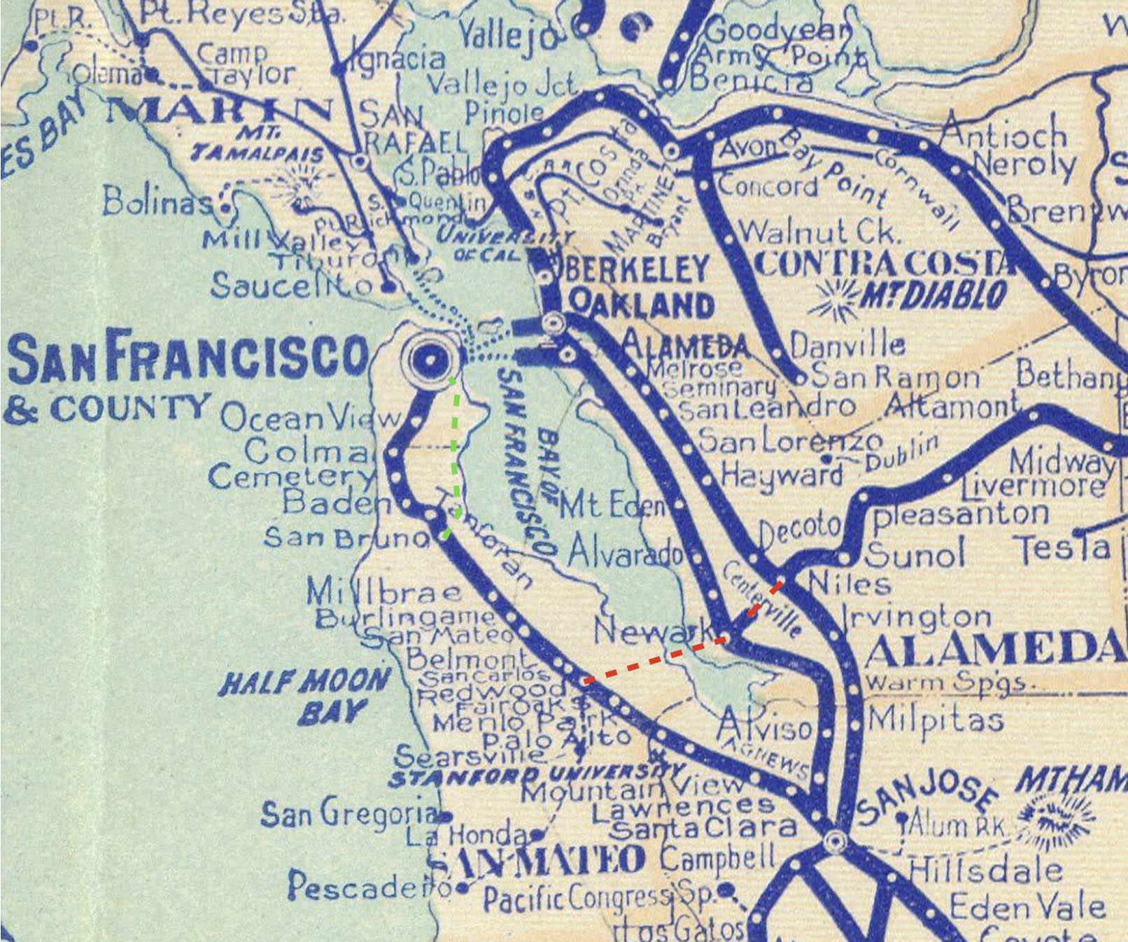
One of Harriman’s first orders of business was to consider the plan raised a quarter century earlier to reduce transit time between San Jose and San Francisco, and finding a quicker way to move freight to San Francisco without using a ferry crossing. As seen in this detail from the 1901 map, The Bayshore Cutoff, green line, was proposed to replace the original 1863 inland route north of San Bruno, and The Dumbarton Cutoff, red line, would require building the first bridge across San Francisco Bay and the first between two counties in the Bay Area.
L343-100-Map of California by the Southern Pacific Company. Courtesy David Rumsey Map Collection, David Rumsey Map Center, Stanford Libraries, (Image 22 of 38)
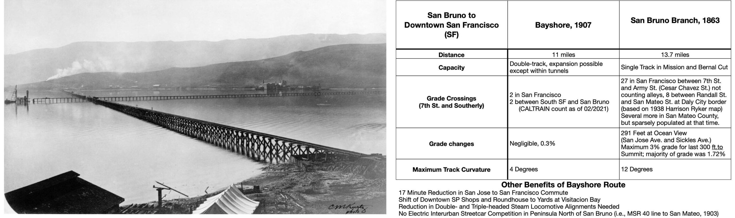
The advantages gained by Harriman’s very expensive and forward thinking project is shown on the right, built between 1904 and 1907. Starting at San Bruno, the Bayshore included five tunnels accounting for almost 20 percent of the total mileage, one permanent trestle, and a cut at Visitacion Point that John Signor noted was 95 feet in depth, and required removal 750,000 cubic yards of earth. The earth was put to good use to fill in Visitacion Bay and the 2.5 mile temporary trestle completed in 1905, left, a south view on May 8, 1905. As reported by the San Francisco Call, Vol. 103, No. 8, Dec. 8th, 1907, the total cost including earthquake damage was said to be 7 million dollars.
Screenshot, (Image 23 of 38)
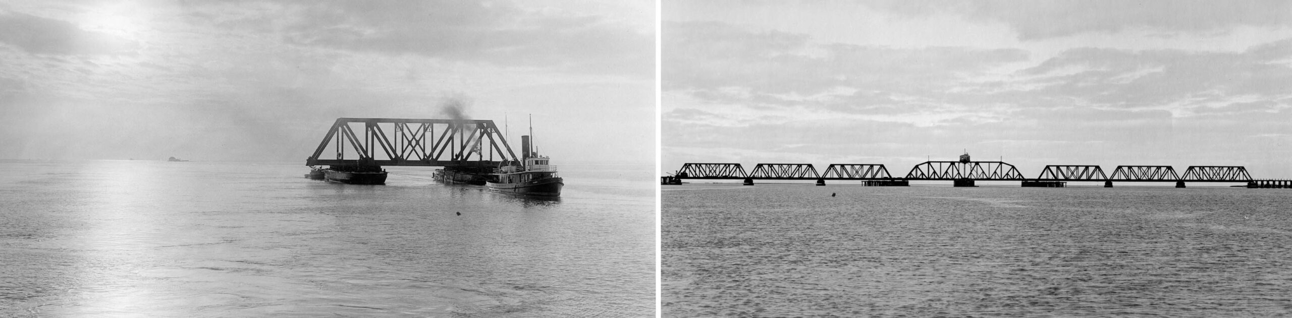
The Dumbarton Cut-off utilized a truss swing bridge, shown here at the onset of its construction on Dec. 9, 1909, left, and on completion on Feb. 21, 1910, right. It connected Newark to Redwood Junction via trestles, and a second small bridge completed in 1908 over Newark Slough after a short segment was built between Niles and Newark in 1907. It reduced the time for a train to get from Oakland to the Peninsula by 26 miles, leaving less reliance on ferries to move freight from Oakland Pier to San Francisco, and a direct route for trains from the east passing through Niles. For a thorough review, past and present, click here.
L343-110-C. M. Kurtz Photos, Courtesy BAERA, Western Railway Museum Archives, (Image 24 of 38)
In addition to the two big cutoff projects, there were other major East Bay-related expenses such as replacement of the Alameda Pier that was destroyed by fire in 1902. Ford notes the estimate replacement costs were $350k, including replacing over 45 railcars. The new pier was said to be the most ornate ferry terminal built by the SP, shown here in a northwest view in 1939 when it was about to closed in favor of the Bay Bridge.
L343-115-Robert S. Ford Collection, Courtesy BAERA, Western Railway Museum Archives, 168440oa&b, (Image 25 of 38)
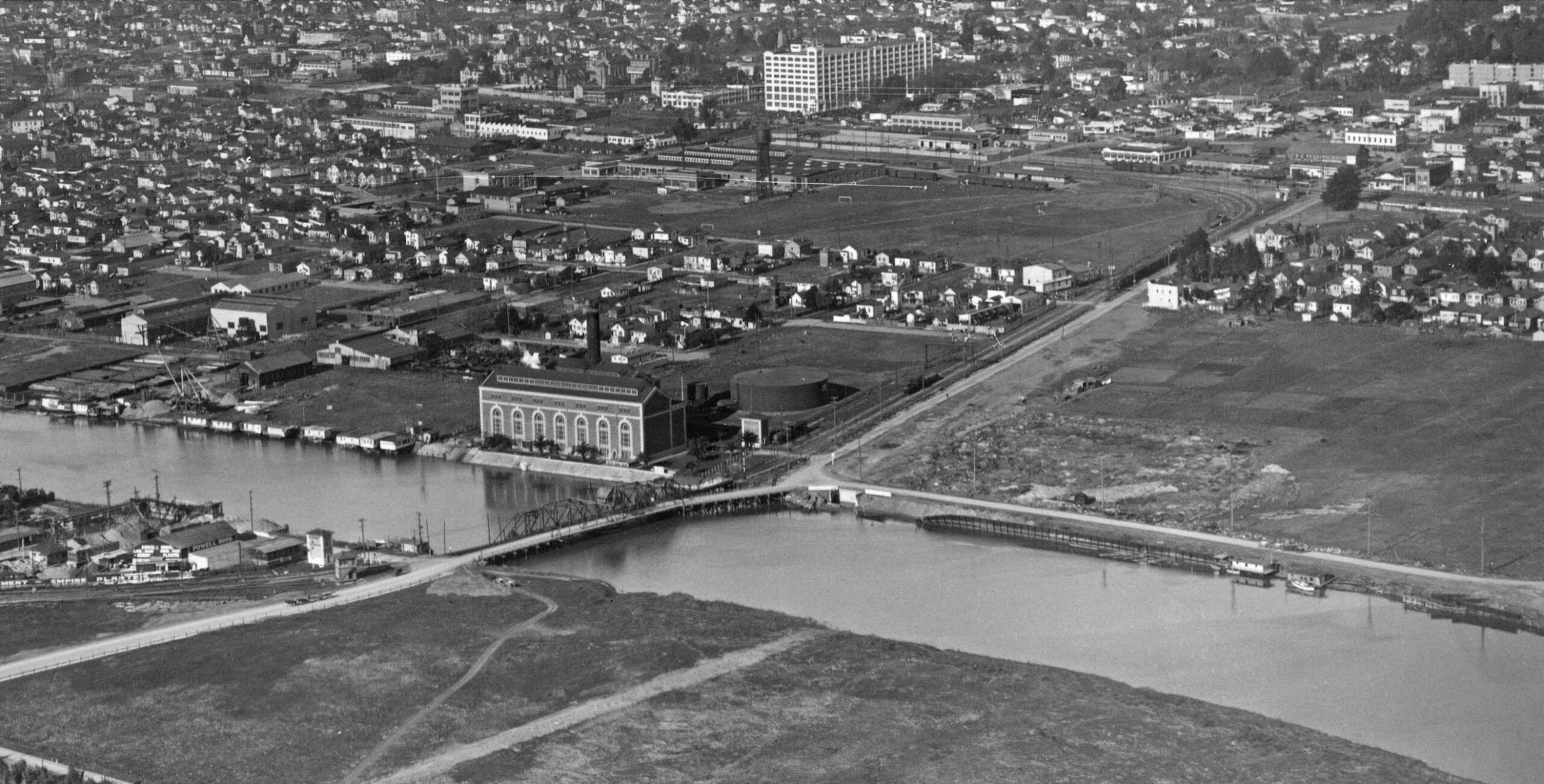
Unlike having the benefit of Smith’s Oakland Traction Co. to have secured power stations, and by the end of the first decade transitioning their facilities to PG&E, the SP put up $900k to build its own oil-powered facility off the estuary near the Fruitvale Bridge, shown here in a north view in the mid-1920s. According to Ford’s research, the selection of this spot to build the plant was based on the availability of low-temperature water and land price. Substation no. 1 was located at the southeast end of the facility. Substations were added in West Oakland and North Berkeley, the latter to be discussed in the next update.
L343-120-George Russell Photo, Courtesy the California State Lands Commission, API 652_16_BOX 95, (Image 26 of 38)
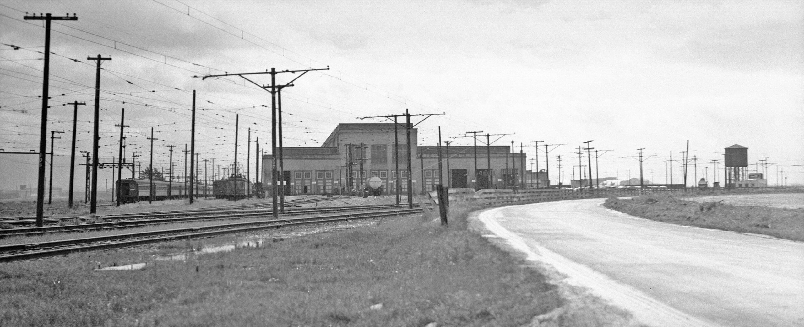
The new railway would need general shops, and by Jan. 1910 the marshland in West Alameda adjacent to an existing yard and roundhouse was being prepared. This panoramic east view shows the 460 feet by 200 feet final building in the spring of 1941 when the facility would soon be be shuttered.
L343-125-Howard T. Wolfe Photo, Courtesy BAERA, Western Railway Museum Archives, 263275ier, (Image 27 of 38)
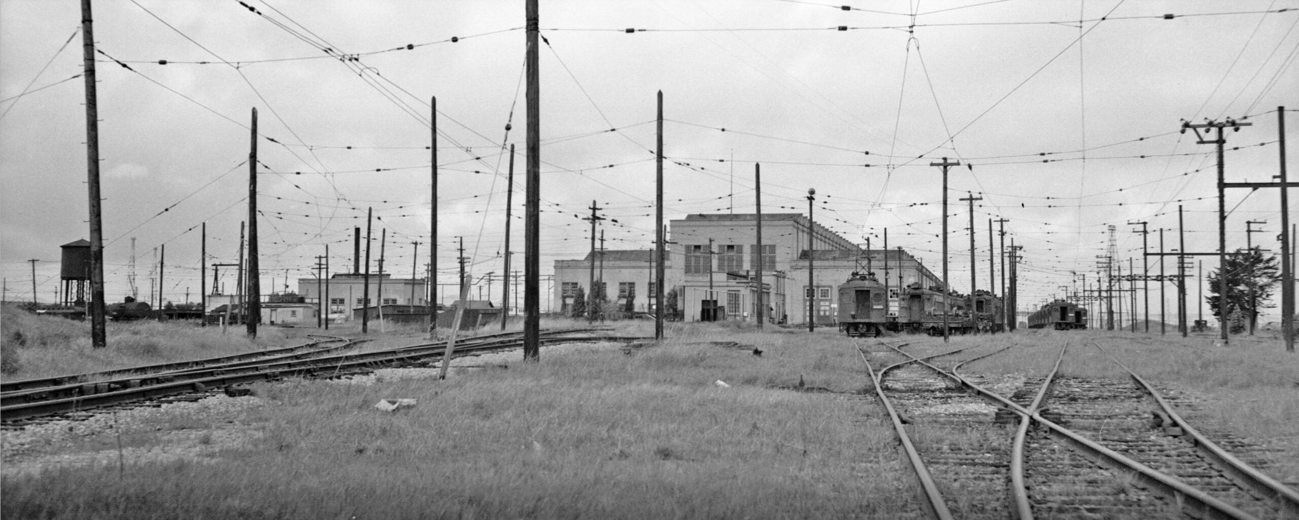
A complementary west view of the facility also from 1941. There was also a substation, a boiler room, a fire pump, and a large air compressor in the facility. It is here that the first set of brand new railcars would be readied for service in 1911.
L343-130-Howard T. Wolfe Photo, Courtesy BAERA, Western Railway Museum Archives, 263274ier, (Image 28 of 38)
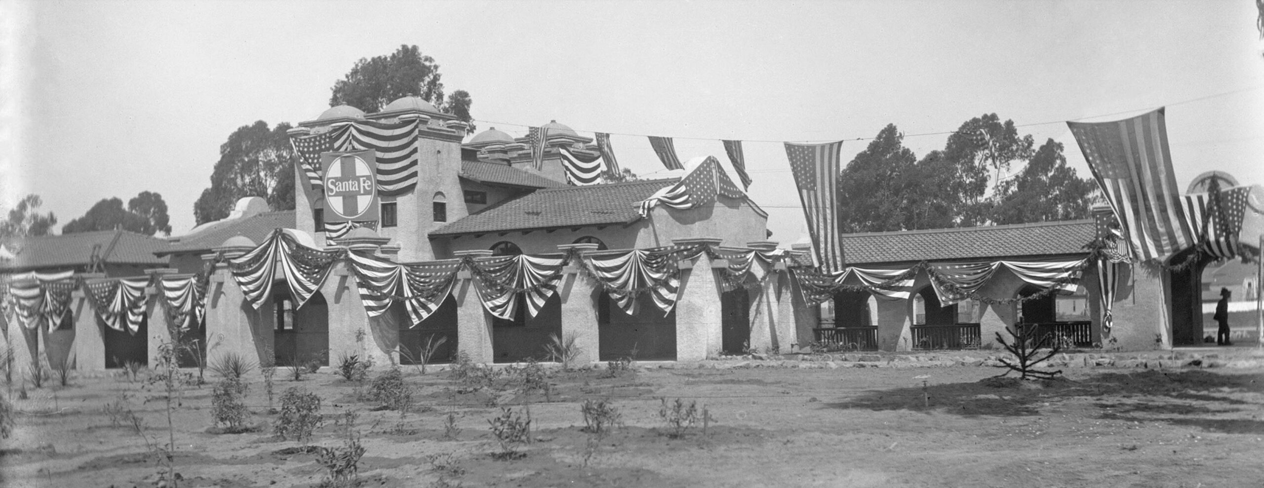
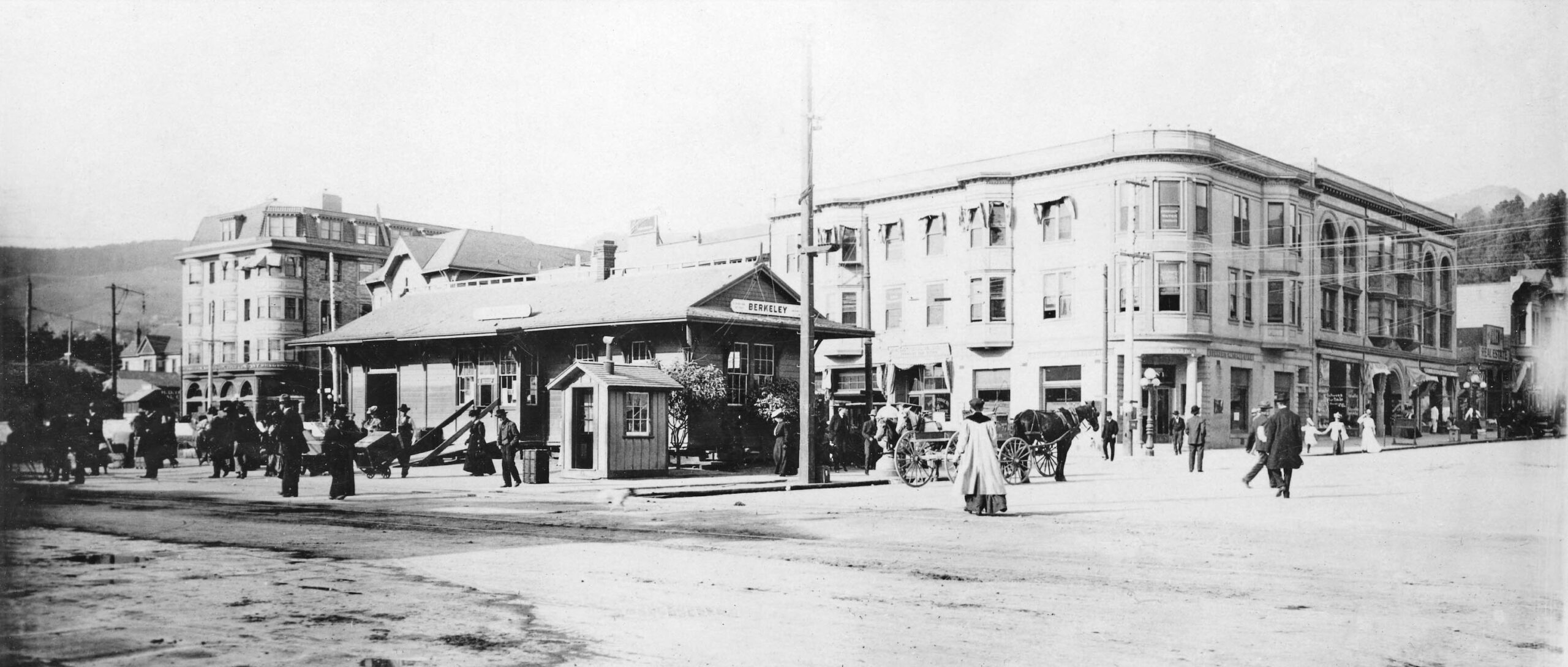
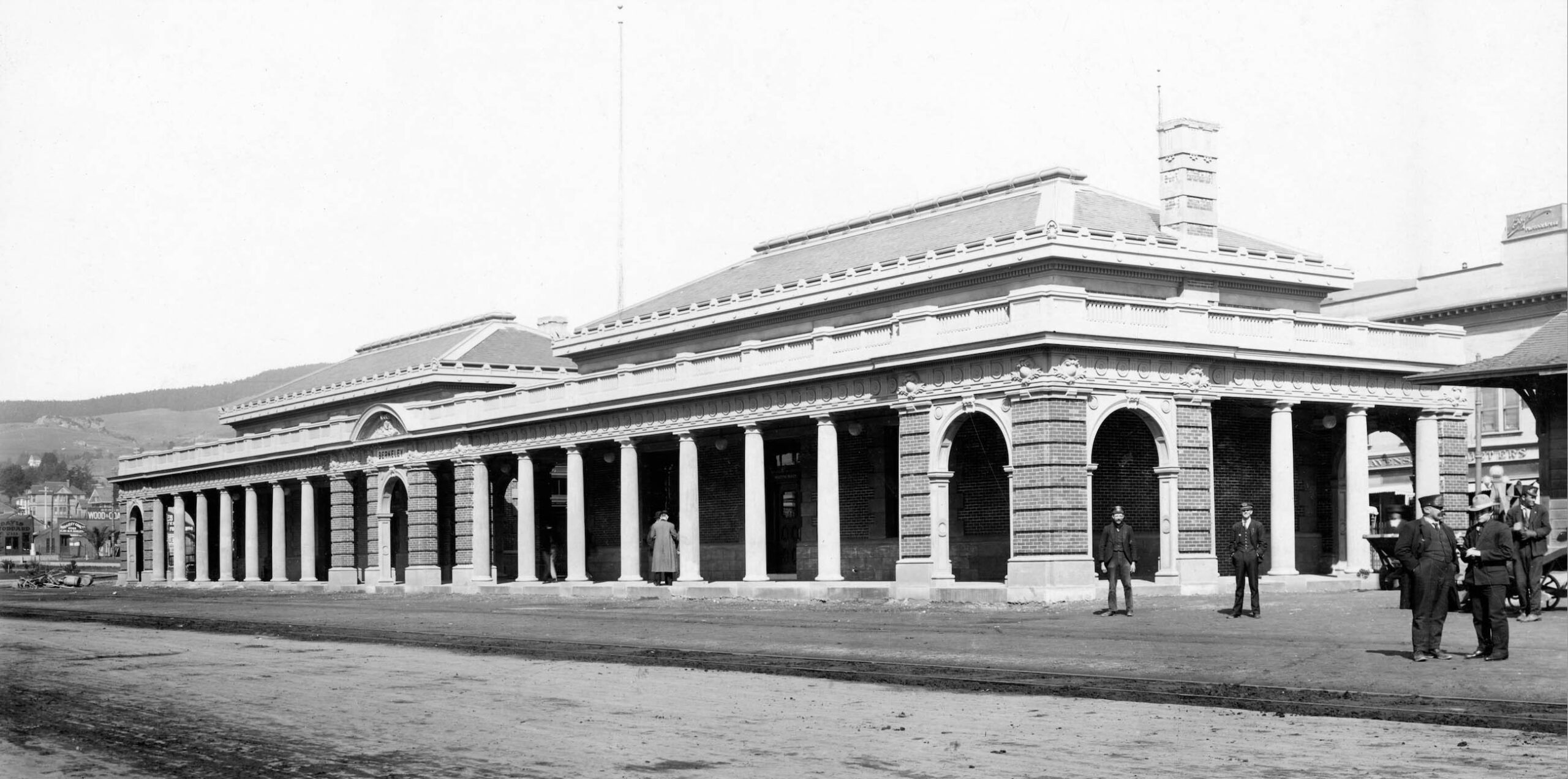
If the expenses mentioned so far were not enough, the coming of the electric system also spurred the construction of four new East Bay station buildings between 1906-1913. New structures that would not serve electric lines were built at 1st St. and Broadway in Oakland, and 3rd St. and University Ave. in Berkeley, each costing in the $25k range. As for electric operations, the small wooden station at Center St. and Shattuck Ave. that had served as the second station for the steam locals shown here in a northeast view in 1903 would be replaced as shown next.
L343-135-SP Official Photo, Courtesy BAERA, Western Railway Museum Archives, (Image 29 of 38)
As Ford notes, construction on the new station was started in late 1906, and opened to the public in Jan. 1908, this northeast view taken around that time. It would serve the steam trains until the end of 1911 when electric service took over.
L343-140-Courtesy BAERA, Western Railway Museum Archives, 170309oa&b, (Image 30 of 38)
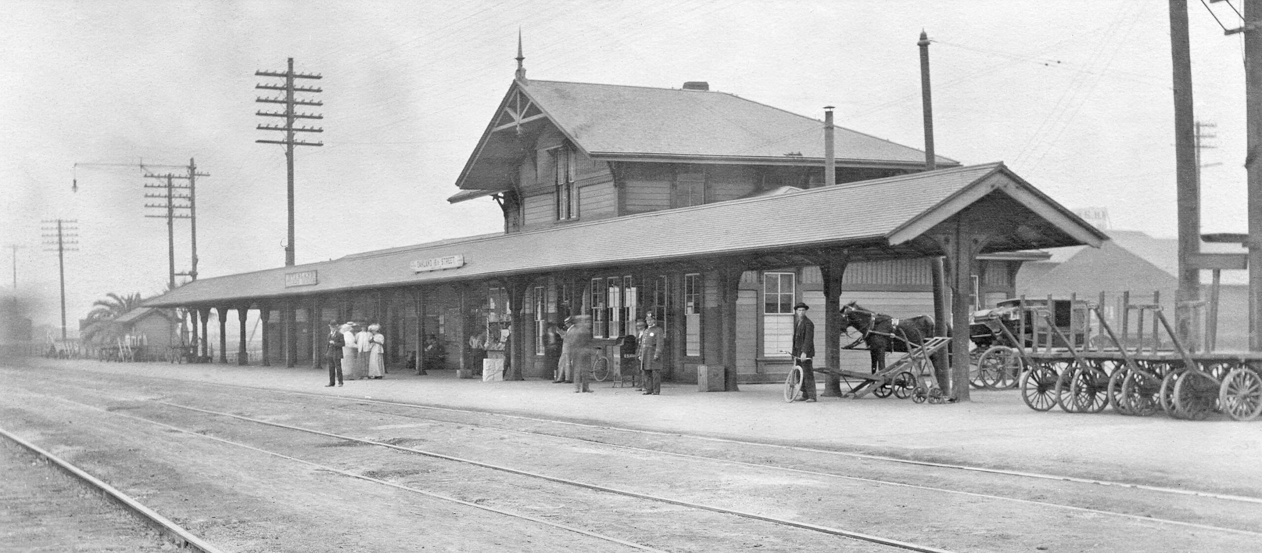
The bigger investment in stations, however, was the replacement of Oakland’s 16th St. station, built in 1876-1877, and shown here in an east view ca. 1910. It was known for its 200 foot long “umbrella” that kept the awaiting passengers protected from the rain.
L343-145-S. P. Official Photo, Courtesy BAERA, Western Railway Museum Archives, 74088sp, (Image 31 of 38)
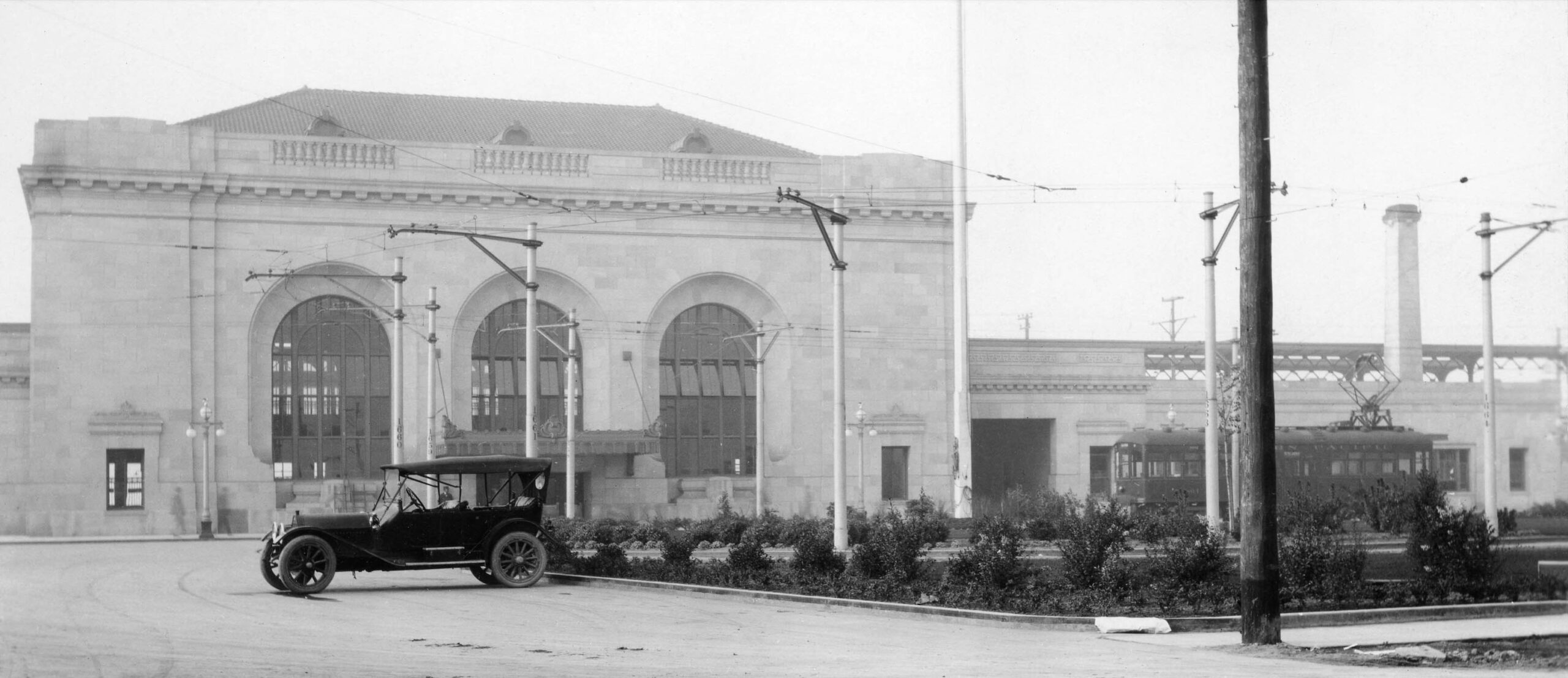
For the new station, Chicago architect Jarvis Hunt was selected. At the time he was constructing several train stations that would eventually wind up on the National Register, such as the Union Stations in Kansas City and Dallas. At somewhere around $375k, the structure was reinforced in concrete with a granite exterior. Its construction was begun in Oct. 1910, and it was mostly completed by Aug. 1912, save for the suburban elevation track connections to be featured next. The small streetcar or “Dinky” seen in this 1913 northwest view would be an added expense by creating a streetcar line from downtown Oakland, although the station would be more than adequately covered by Oakland Traction Co.
L343-150-S. P. Official Photo, Courtesy BAERA, Western Railway Museum Archives, 74110sp, (Image 32 of 38)
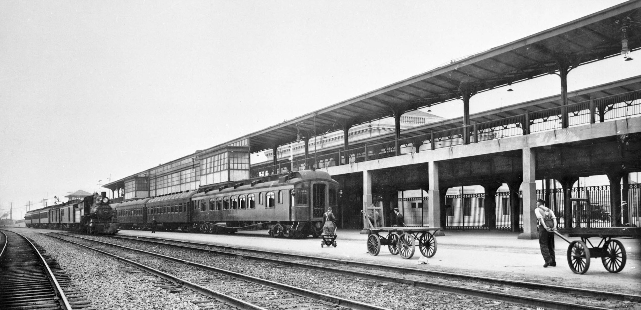
This northeast view ca. 1915 of the train boarding portion of the station shows the ground level for the steam trains, and the elevated level for the new electric lines into Berkeley, that portion ready for service on Feb. 19, 1914. According to Ford, the 3844 foot length of wooden trestle to get the trains to this level and back to the ground level chipped in at nearly $0.5M.
L343-155-S. P. Official Photo, Courtesy BAERA, Western Railway Museum Archives, 58195sp, (Image 33 of 38)
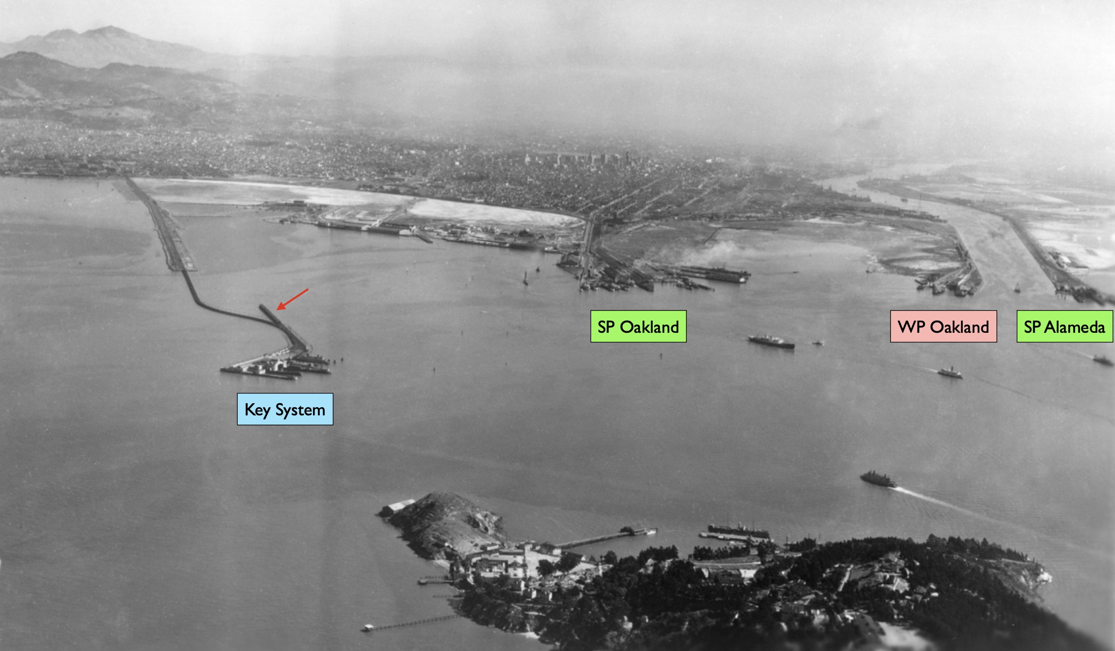
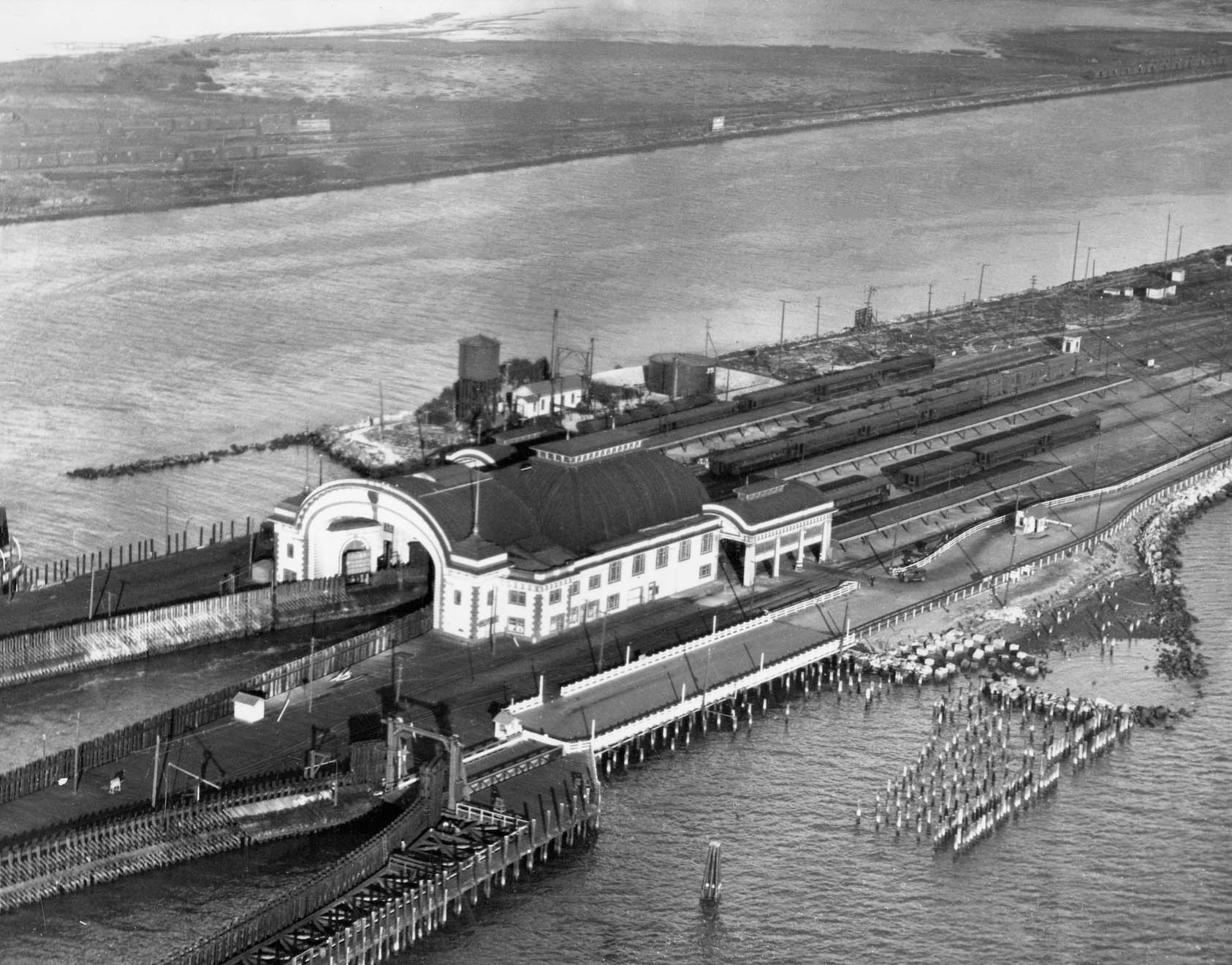
Finally, there were the costs to adapt the Oakland Pier for both steam and electric trains, the pier shown here in a southeast view from 1922. Ford adds that the curve leading from the multiple tracks leaving the Oakland Pier had to be reconfigured as the alignment had the reputation for many grade crossing incidents and had been dubbed “Death Curve”. That reconfiguration added another $750k to the total cost of the project.
L343-160-George Russell Photo, Courtesy the California State Lands Commission, API 650_23_BOX 940, (Image 34 of 38)
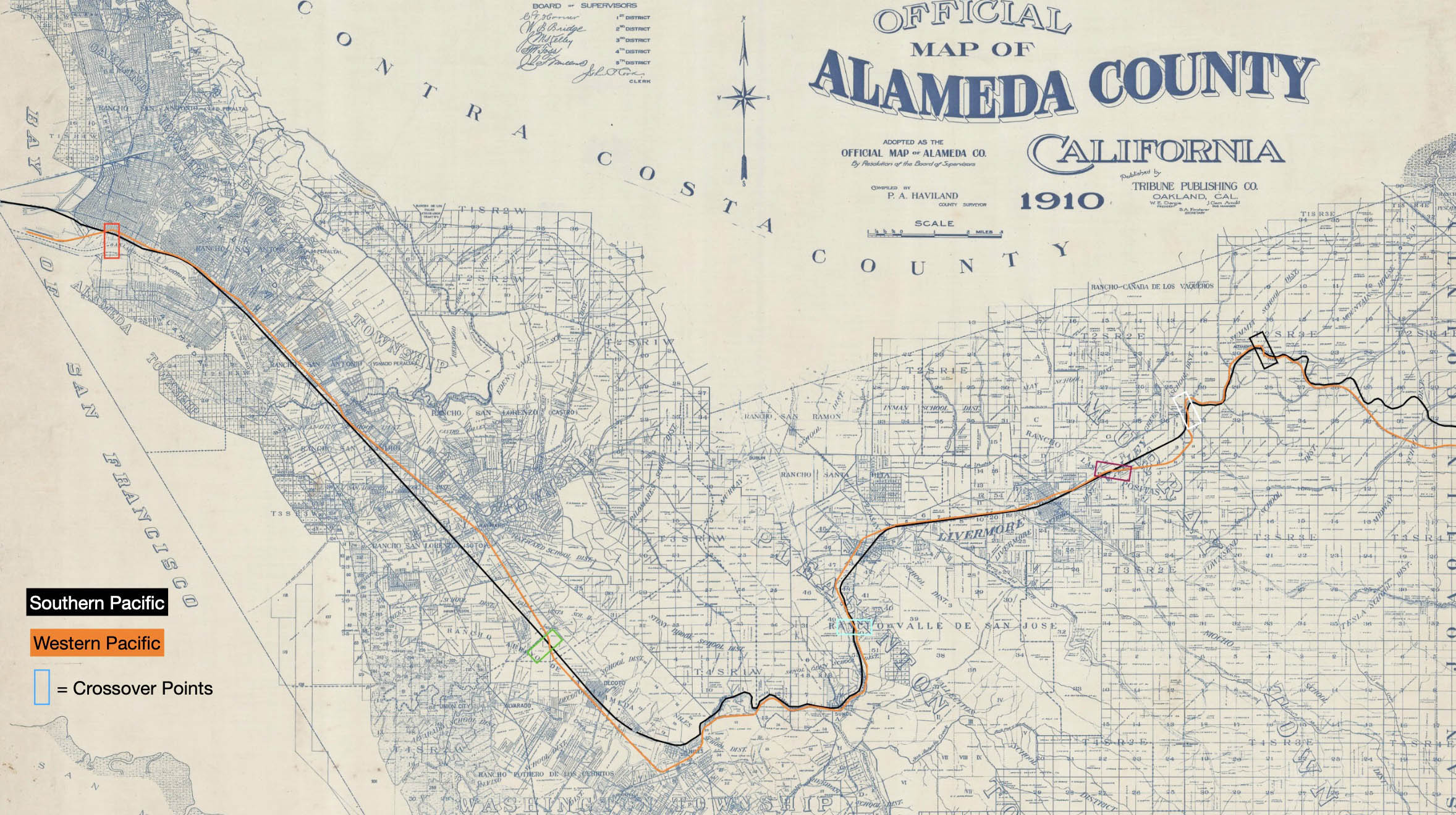
If all these costs were not enough, by 1909 a new competitor made it into town, the Western Pacific, WP, this map from 1910 showing that the new entry stayed close to the SP all the way through Alameda County, with primarily overhead crossings until into Oakland where it crossed the SP mainline at Chestnut St. and 1st St., just east of both railroads’ yards and entry to their piers. By this date, the SP failed in their efforts to block the WP from creating a pier using their claim of the waterfront.
L343-165 Courtesy of the Earth Sciences and Map Library, UC Berkeley, G4363_A3_1910_A5a, (Image 35 of 38)
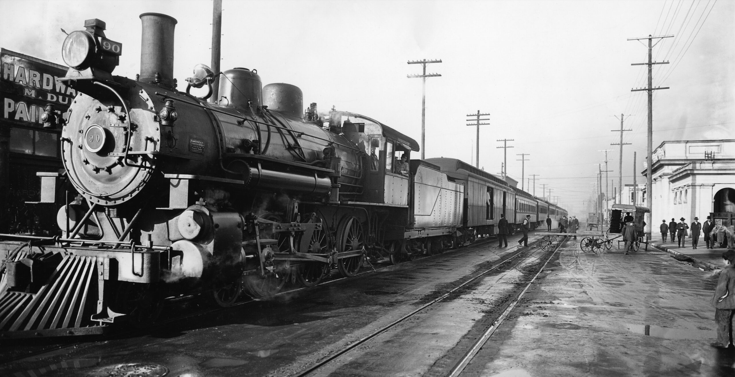
The WP would construct their main passenger Oakland station at 3rd St. between Broadway and Washington St., shown here along the right edge in a northeast view ca. 1912 with WP locomotive no. 90 leading a passenger train.
L343-170-Herrington-Olson and Sappers Collections, Courtesy BAERA, Western Railway Museum Archives, 26675wp, (Image 36 of 38)
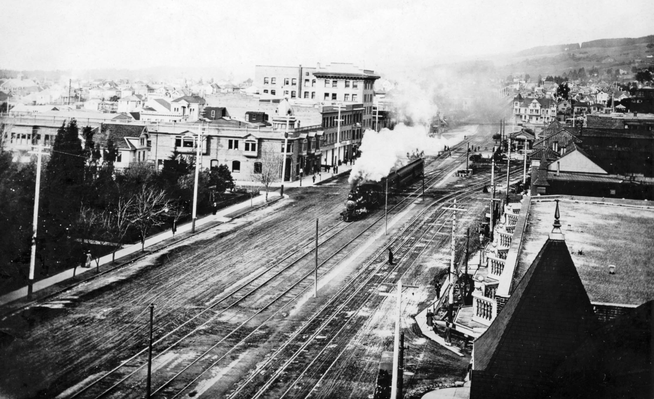
By 1910, A. E. Harriman would have passed away the year before, and they now had competitors to their local and transcontinental steam service in the East Bay. This north view ca. 1904 into downtown Berkeley shows a SP steam train running alongside the Key tracks. Ford continues that the SP was losing ridership to the Key on the Shattuck line. The SP rides within Berkeley for 35 years had been free, as transbay fares were collected at the Ferry Building in San Francisco. Still, it was cheaper to switch to the Key if you were going across the Bay. The loss in ridership would force the SP to charge a nickel for East Bay-only rides, announced on Apr. 11, 1904.
L343-175-Sappers Collection, Courtesy BAERA, Western Railway Museum Archives, 215745sp, (Image 37 of 38)
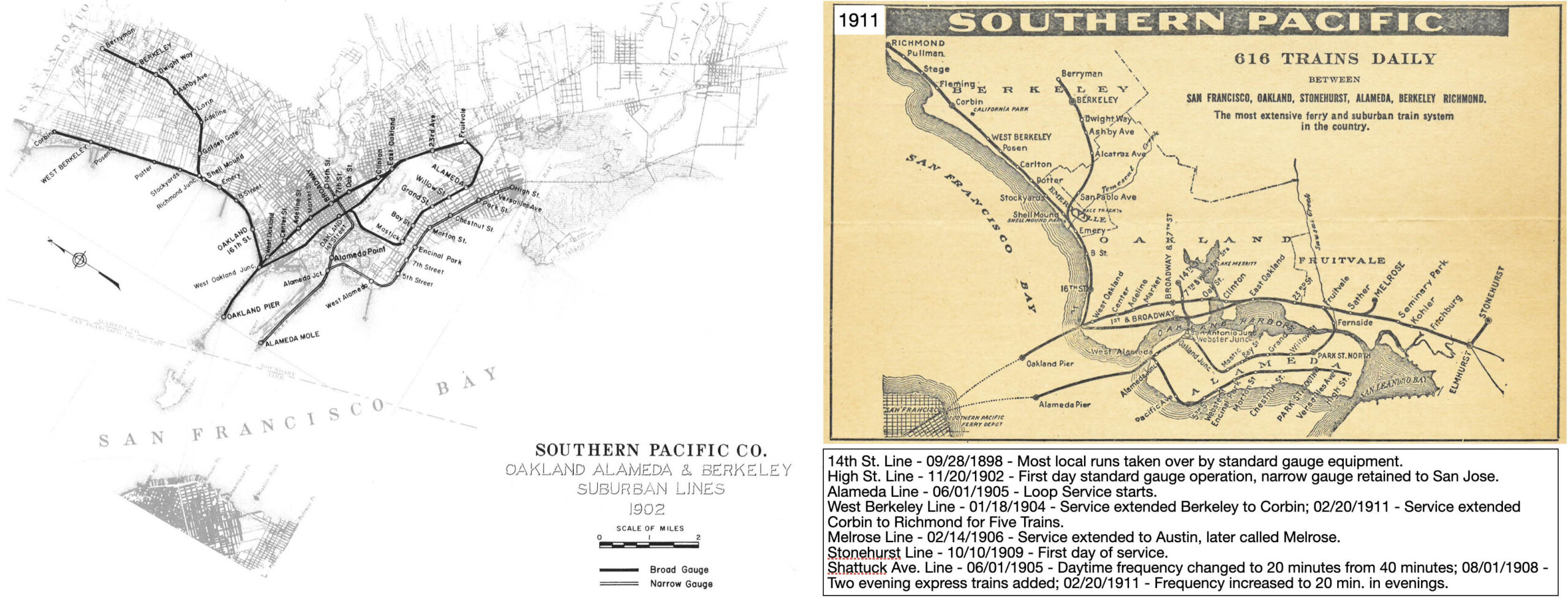
Between the start of Key service and 1911, the SP made several changes to their steam train system in an attempt to improve service. The maps of the SP system between 1902, left, and 1911, are shown here, and a list of some of the major changes the SP made during that interval are shown below the latter map. The next update will review the construction of the completed SP and Key systems servicing Berkeley in 1912, and reveal the forces that accelerated the battle for its ridership. Ref: right, https://en.wikipedia.org/wiki/East_Bay_Electric_Lines
L343-180-Robert Ford Collection, Courtesy BAERA, Western Railway Museum Archives, l, Wikipedia, r, (Image 38 of 38)