Reconstructing the Key Central Car House Private Right of Ways – 3rd. Ave. and E. 18th St.
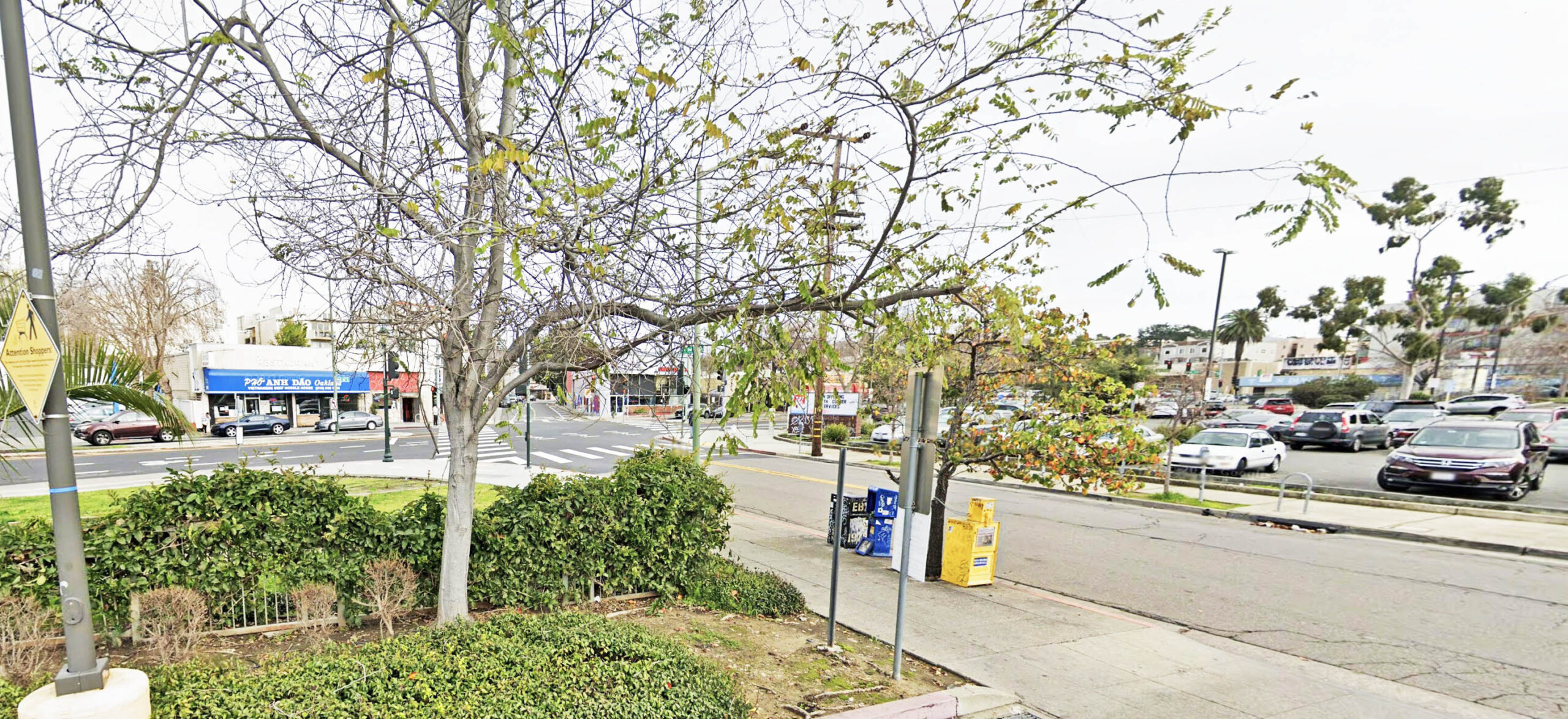
This update will begin where the last one left off, that is, where the two private right-of-ways to and from the Key System, KS, Central Car House originated northeast from the facility. In 2025, the area of interest is hard to photographic in the fall due to trees. Google Maps took the image shown here in Jan. 2023 when partial visibility was available. What looks like an unremarkable intersection at 3rd Ave. and E. 18th St. in this northeast view was once a high volume streetcar crossing in the first half of the 20th century.
L336-05-Courtesy Google Maps, (Image 1 of 43)

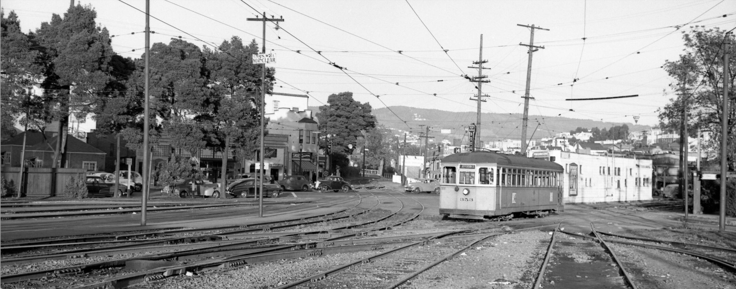
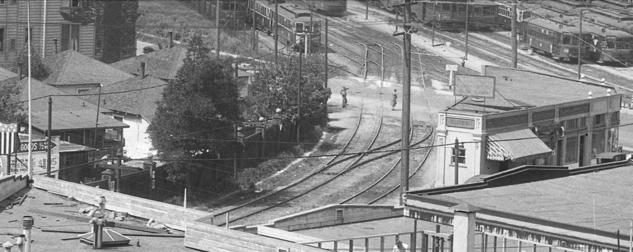
Unlike the southwest entry to the Central Car House, the northeast side was a tangle of tracks representing consolidation and distribution of two routes. KS 353, Line 14 is seen in its inbound approach from E. 18th St. via a short cut in Sept. 1947, northeast view. To the left of the streetcar is the longer cut through what is 3rd Ave. in 2025. Among the storefronts on E. 18th St. west of 3rd Ave. is Baggy’s Buffet as it was listed in the 1940s at no. 288, still in business in 2025, and at the left edge, two cottages from long gone George Ct. bungalows.
L336-10-Fred Matthews Photo, Moreau Collection, Courtesy BAERA, Western Railway Museum Archives, 90276ks, (Image 2 of 43)
An aerial overview of the car house and its private right-of-ways in 1937 vs. 2024 is shown here. An annotated version follows.
L336-15-Harrison Ryker Photo V5-142, Courtesy California Department of Transportation, l, and Google Maps, r, (Image 3 of 43)
Continuing from the description from the previous update on this subject, this update will focus on the private right-of-way joining E. 18th St. and the car house at the 3rd Ave. side, yellow broken line, herein to be referred to as the “E. 18th St. Cut”, and the private right-of-way shown by the green broken line that was a passage way for the Line 18 streetcar to access Park Blvd., herein to be referred to as the “3rd Ave. Cut.”
L336-20-Harrison Ryker Photo V5-142, Courtesy California Department of Transportation, l, and Google Maps, r, (Image 4 of 43)
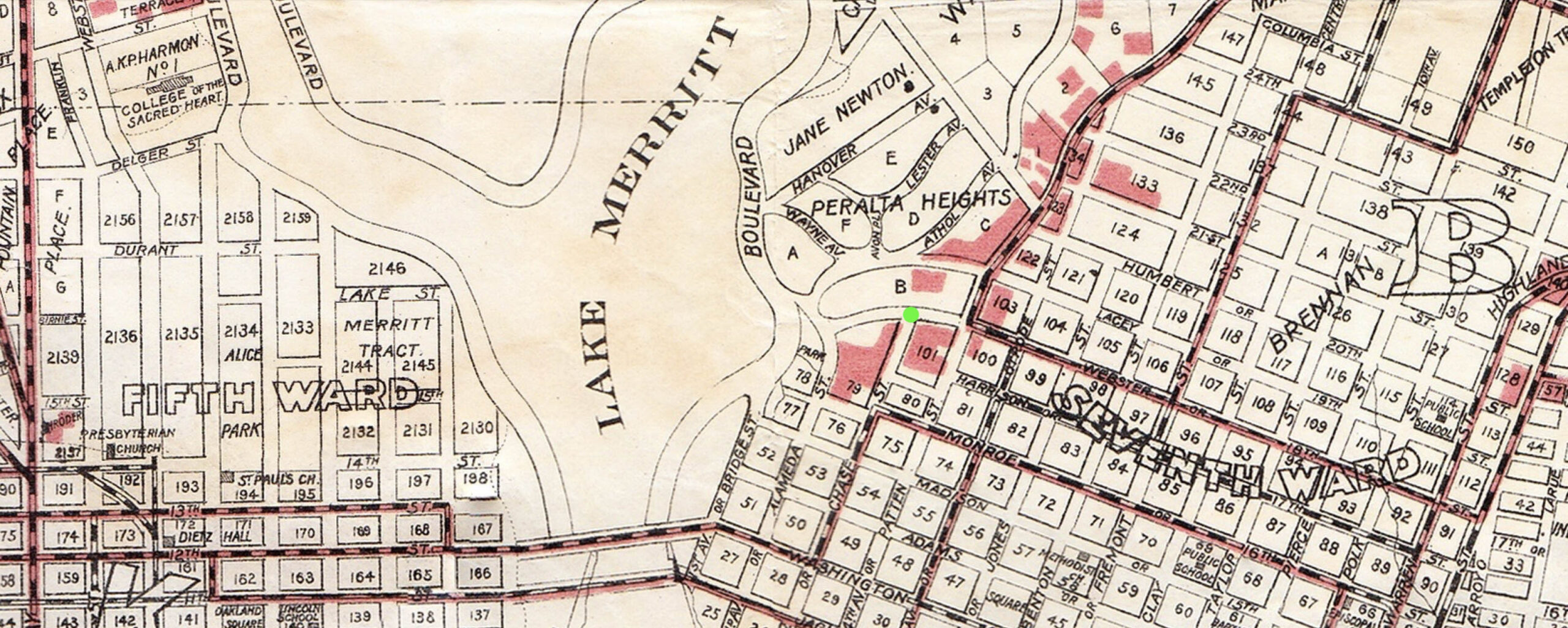
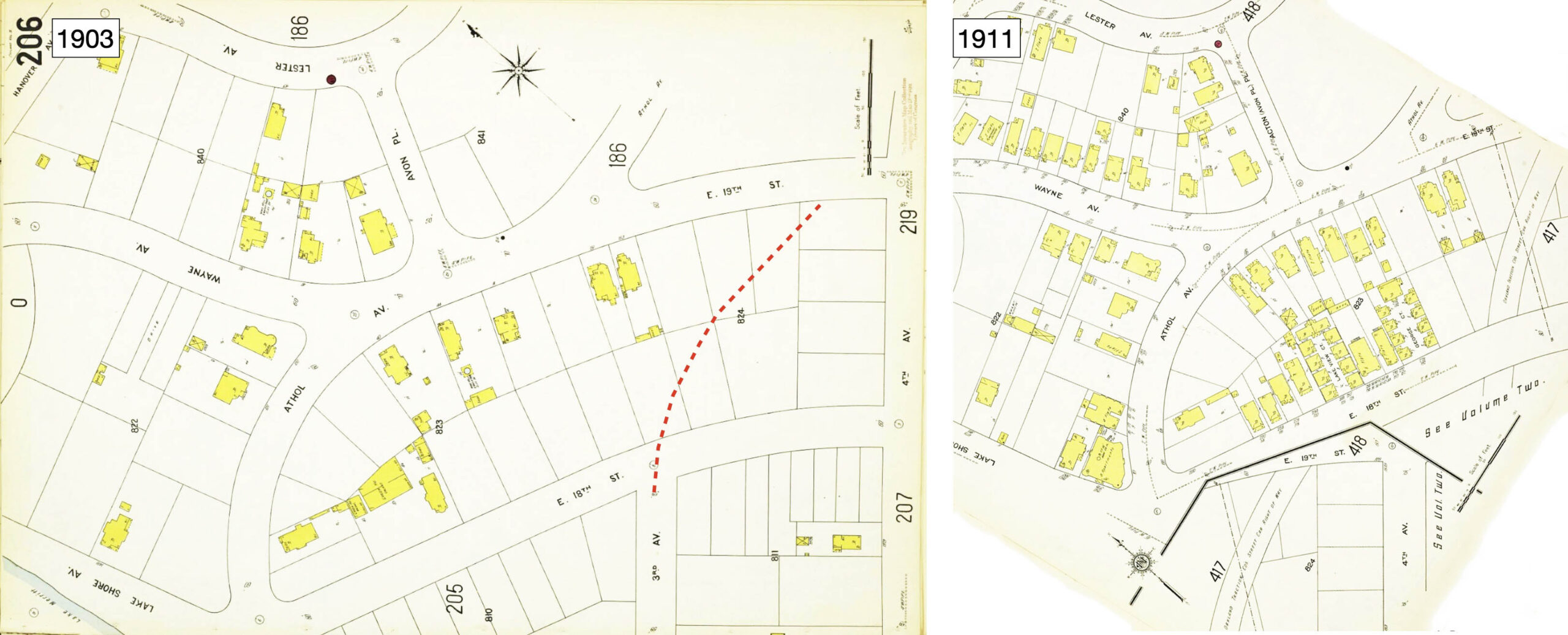
The previous update provided evidence from maps that the area of the Central Car House had been under the edges Lake Merritt in the 19th century. This map from 1903 places a green dot at the future intersection of 3rd Ave. and E. 18th St. showing that the basic grid of the area had been in place as car house construction and creation of the private right-of-ways were imminent.
L336-25-Woodward, Watson and Co. Map of Oakland, Courtesy John Bosko, (Image 5 of 43)
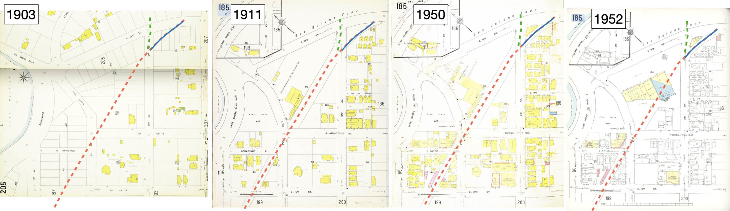
Using these Sanborn maps as guides, the red broken line shows the path through the Central Car House. The green broken line shows the initial path of the 3rd Ave. Cut across E. 18th St., the solid blue line shows the path of the E. 18th St. Cut onto E. 18th St.
L336-30-Library of Congress, Geography and Map Div., Sanborn Maps Coll., Panels 205-206 from 1903 Vol 2, l, 185 from 1911 Vol. 2, cl, 185 from 1911-Nov 1950 Vol. 2 , cr, 185 from 1911-1952 Vol. 2, r, (Image 6 of 43)
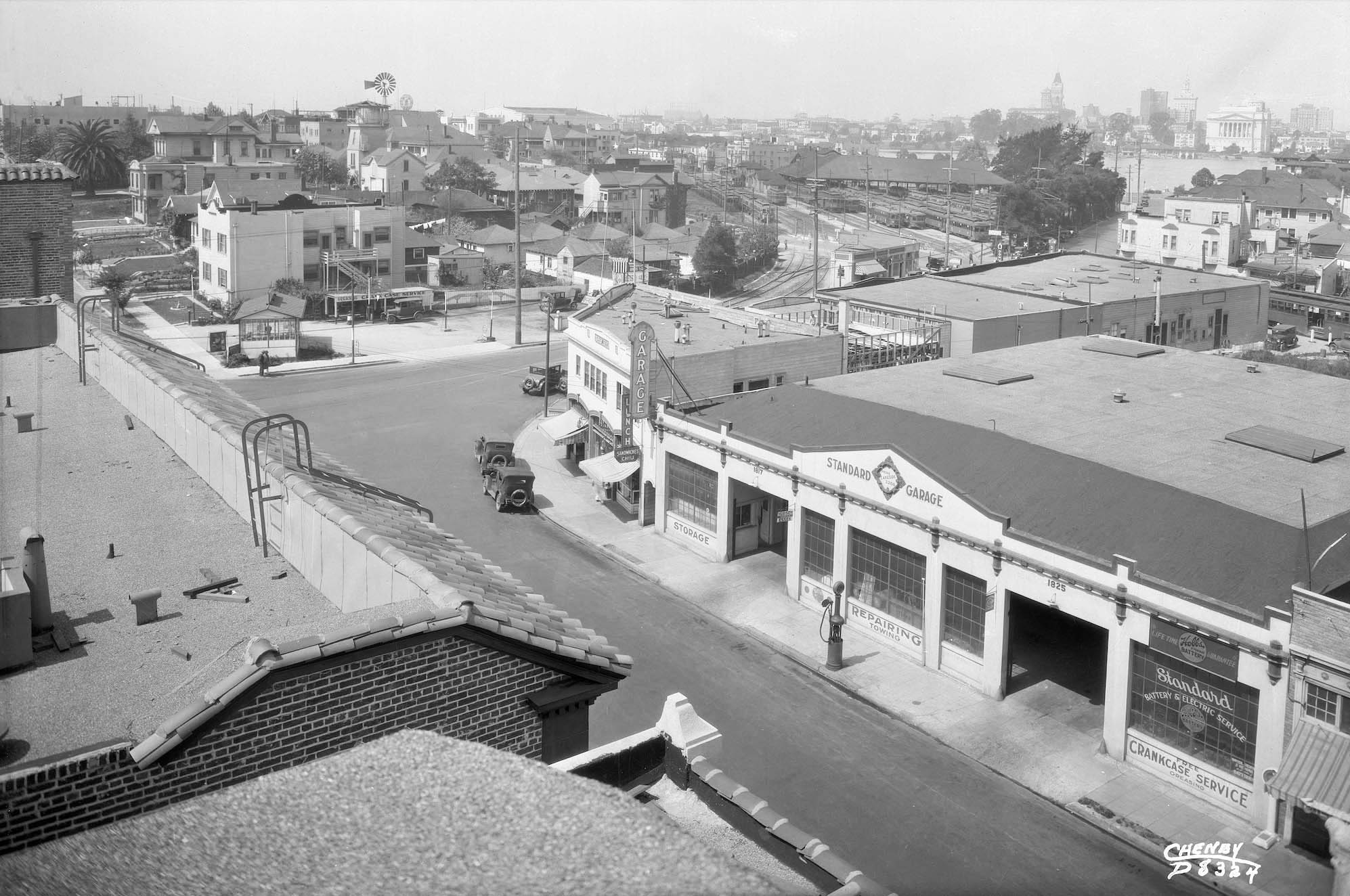
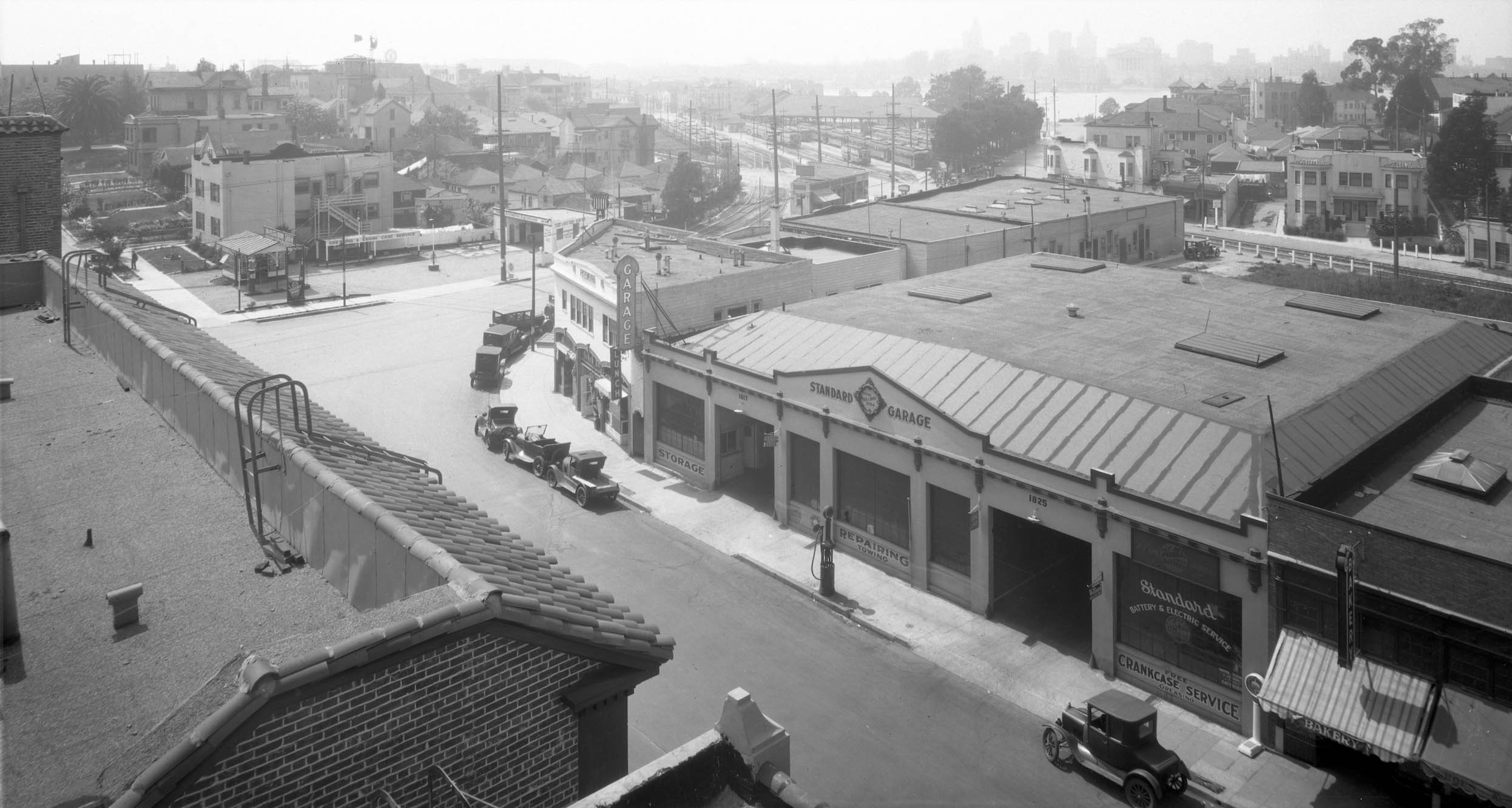
Ahead to ca. 1926-1927, here displayed is a west view with the car house and Oakland City skyline taken from the roof of the Parkway Theater, the theater reviewed in the last update. A detail follows …
L336-35-Cheney Photo D 8324, Sappers Collection, Courtesy BAERA, Western Railway Museum Archives, 45849ks, (Image 7 of 43)
The detail from the previous oblique view shows the E. 18th St. Cut, the triangular shaped building between the cut and E. 18th St., and the cottages on the east side of the cut. The detail shows Blake & Hinrichs, listed for the first time in Polk’s Classified Business Directory at no. 307 E. 18th in 1925, and at nos. 307-311 E. 18th in 1926. A full directory listing in 1927 read as G. L. Blake and H. H. Hinrichs, Ford Parts, Auto Accessories, Tires and Tubes, Sections and Retreads. 307-311 E. 18th. The next panel continues on the analysis of this detail.
L336-36-Cheney Photo D 8324, Sappers Collection, Courtesy BAERA, Western Railway Museum Archives, 45849ks, Detail, (Image 8 of 43)
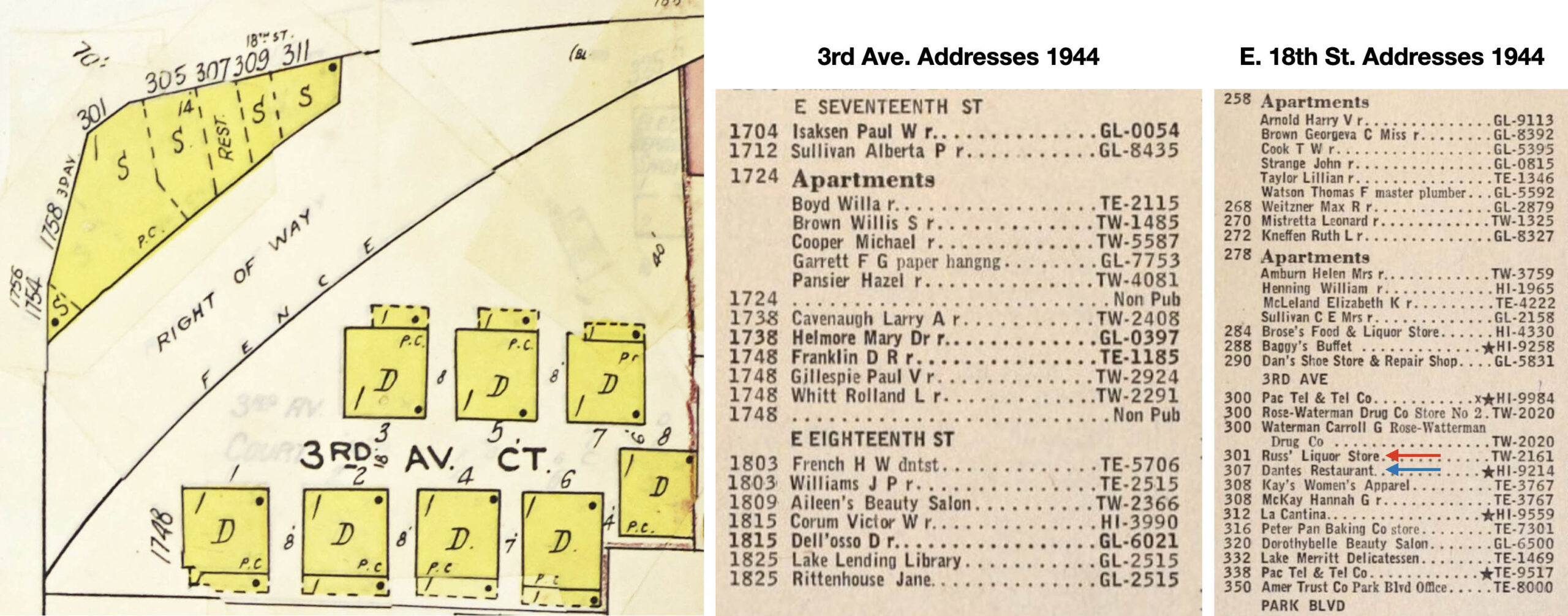
This enlargement of the Sanborn map updated to 1950, left, shows the numbering of the storefronts on the 3rd Ave. and E. 18th St. sides of the triangular building, and the cottages in 3rd Ave. Ct. The listing of addresses in the reverse directory from 1944 have only two of the structures, not ruling out the others were occupied without phone service. The liquor store at no. 300 changed names frequently, Brose Wine and Liquor Store in 1938, and Consolidated Liquor Store in 1940. Interestingly, no. 309 was listed as a residence for Esther E. Roy in 1940.
L336-37-Library of Congress, Geography and Map Div., Sanborn Maps Coll.,Panel 185 from 1911-Nov 1950 Vol. 2, l, Internet Archives, c and r, (Image 9 of 43)
With the information just presented at hand, next to explore the E. 18th Cut, red arrow. The aerials from 1937 and 2024 are a reminder that nothing remains in 2025 of the cut’s existence or the structures on either side of it just reviewed. References to specific streetcar lines in the presentation that follows will go beyond the routes used in the late 1940s, as some images captured excursions, training runs or cars leaving storage. The KS streetcar division during the 1936-mid 1946 period was called East Bay Transit Co., but for this presentation, all cars are called KS, the designation after this time period.
L336-40-Harrison Ryker Photo V5-142, Courtesy California Department of Transportation, l, and Google Maps, r, (Image 10 of 43)
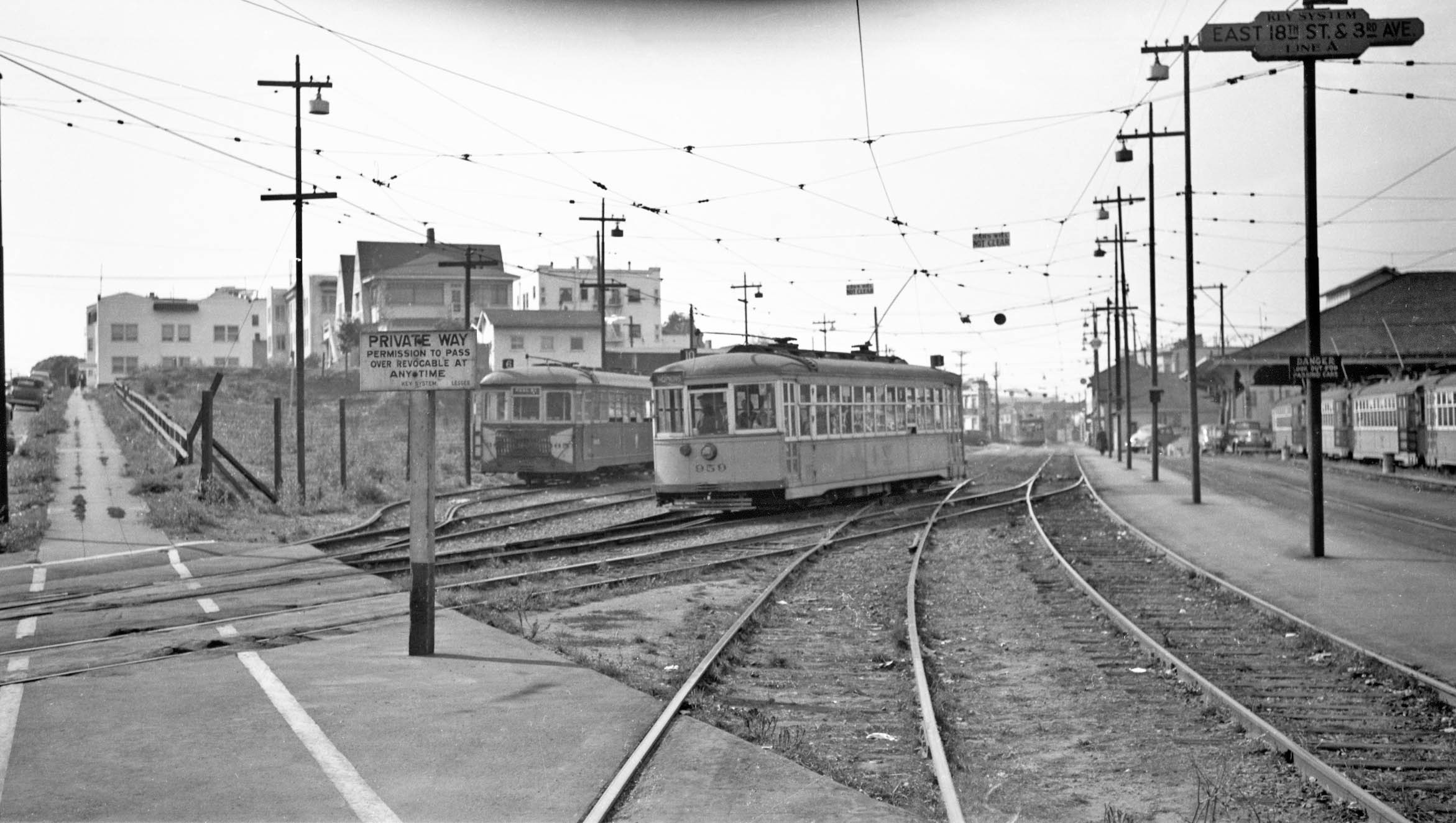
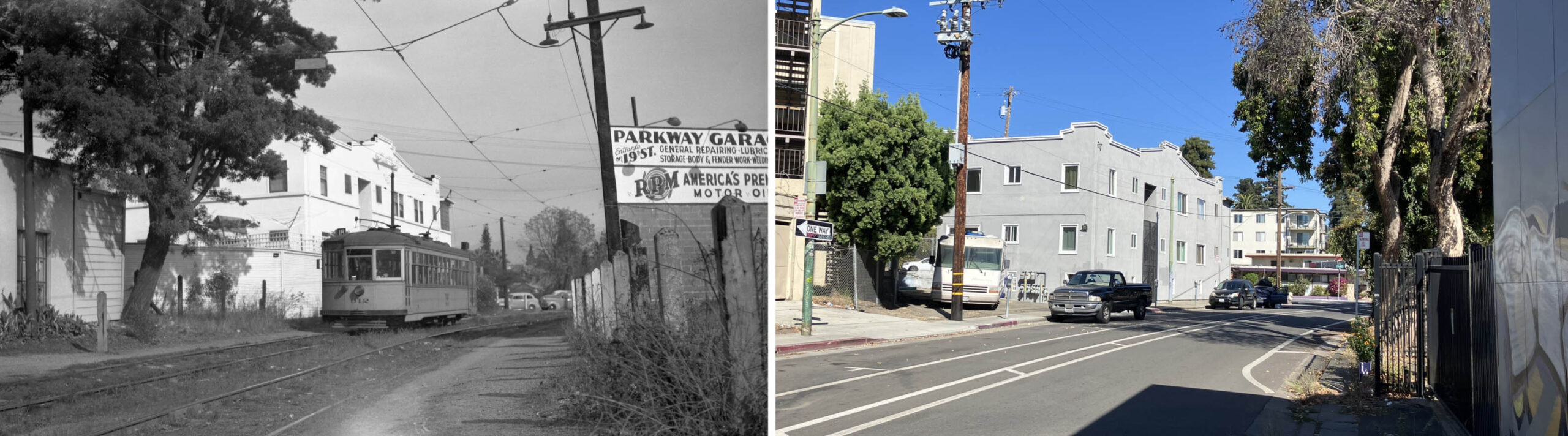
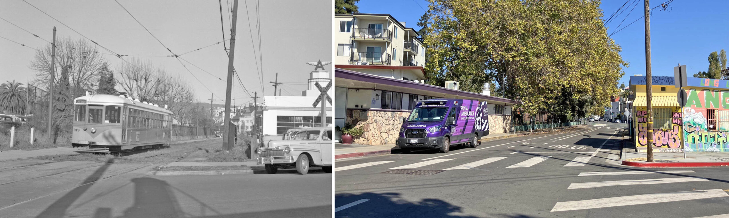
This southwest view from 1939 shows the the tracks to the 3rd. Ave. Cut on the right, and the E. 18th Ave. Cut on the left with KS 959, Line 10. The Line 6 streetcar’s presence cannot be explained since it did not use this car house at that time. This view down 3rd. Ave. has been obscured since the early 1950s by the presence of the Lucky Supermarket. The house just above the private way sign, no. 238 Foothill Blvd., is the only structure from the 18th century in this locale surviving to 2025, although it has been modified. Its construction was completed on Feb. 10, 1899 by A.T. Spence, builder, and the Cunningham Bros., architects.
L336-45-Wilbur C. Whittaker Photo, Harry Aitkin Collection, Courtesy BAERA, Western Railway Museum Archives, 165128ks, (Image 11 of 43)
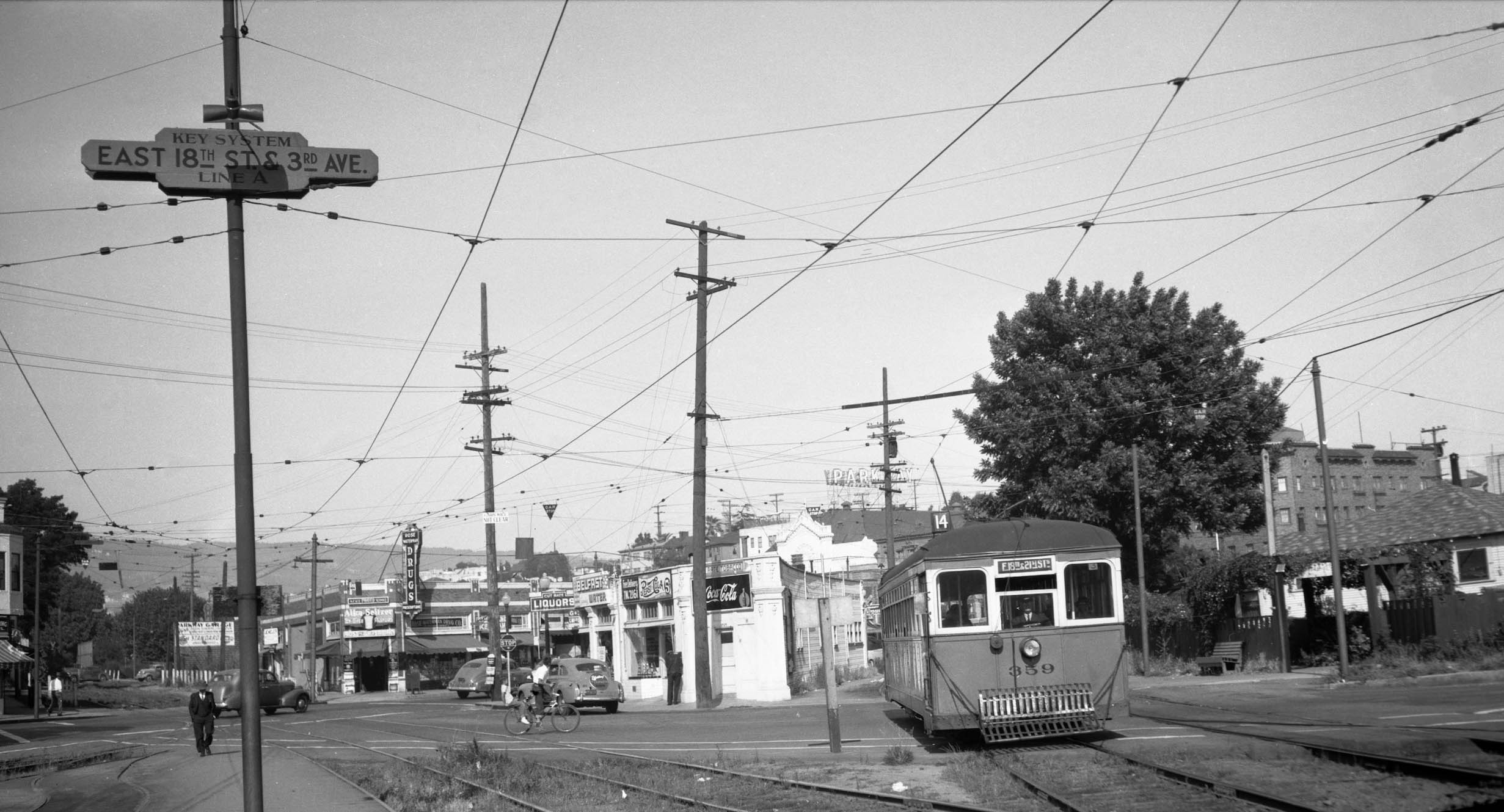
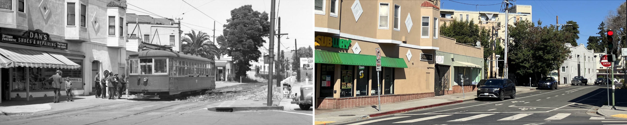
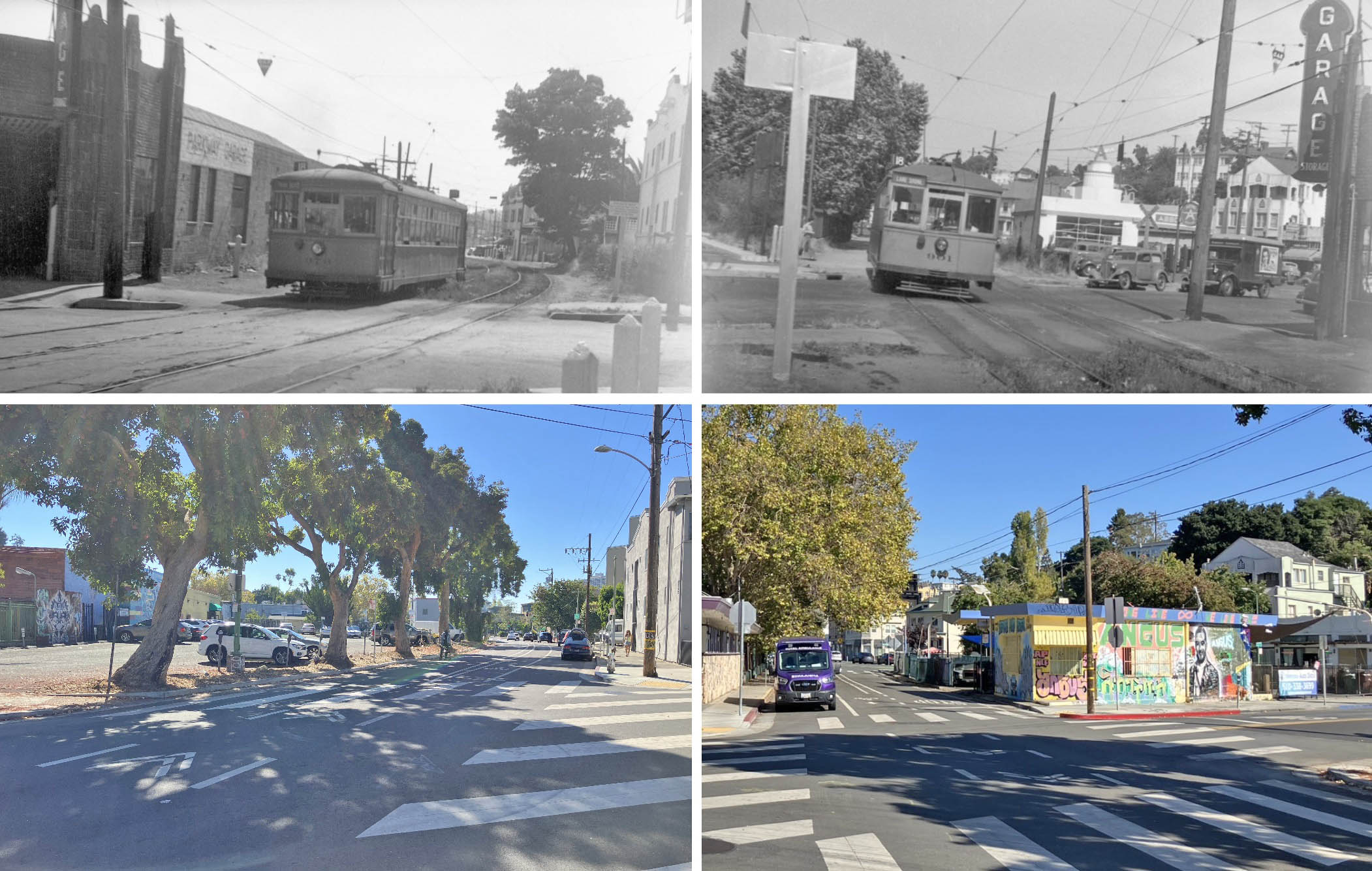
This northeast view at 3rd Ave. and E. 18th St., of KS 359, Line 14 from July 9, 1941 provides new information. Starting from the left edge, a sliver of Dan’s Shoe Store and Repair Shop, no. 290 E. 18th St., is a persisting marker as the Subway Shop in 2025. The station sign indicates that the interurban Line A used the track at the start to the 3rd. Ave. Cut. The drug store across E. 18th St. can be identified as Rose-Waterman Co. at no. 300 as indicated in L336-67. The occupants on the 3rd Ave. side of the triangular building could not be ascertained. The roof top of the Parkway Theater stands tall in the background, and the 3rd Ave. Ct. cottages line the right edge.
L336-50-Wilbur C. Whittaker Photo, Walt Vielbaum Collection, Courtesy BAERA, Western Railway Museum Archives, 218803ks, (Image 12 of 43)
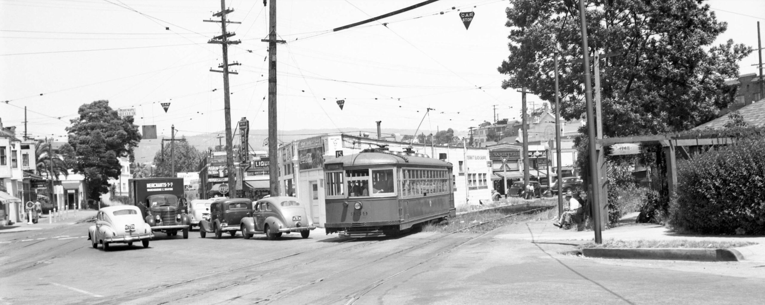
A similar northeast view of KS 939, Line 15 in the cut on June 15, 1946 shows a sign for the Merritt Slack Shoppe, not listed in directories at that time. The entrance to the 3rd Ave. Ct. cottages is indicated by the no. 1748 sign This was the second iteration of Line 15, this portion had been part of Line 10 that was divided up by order of the Office of Defense Transportation on Sept. 26, 1943 according to Sappers. For an excellent review of ODT, click here.
L336-55-Peter Kyhn Photo, Courtesy BAERA, Western Railway Museum Archives, 132345ks, (Image 13 of 43)
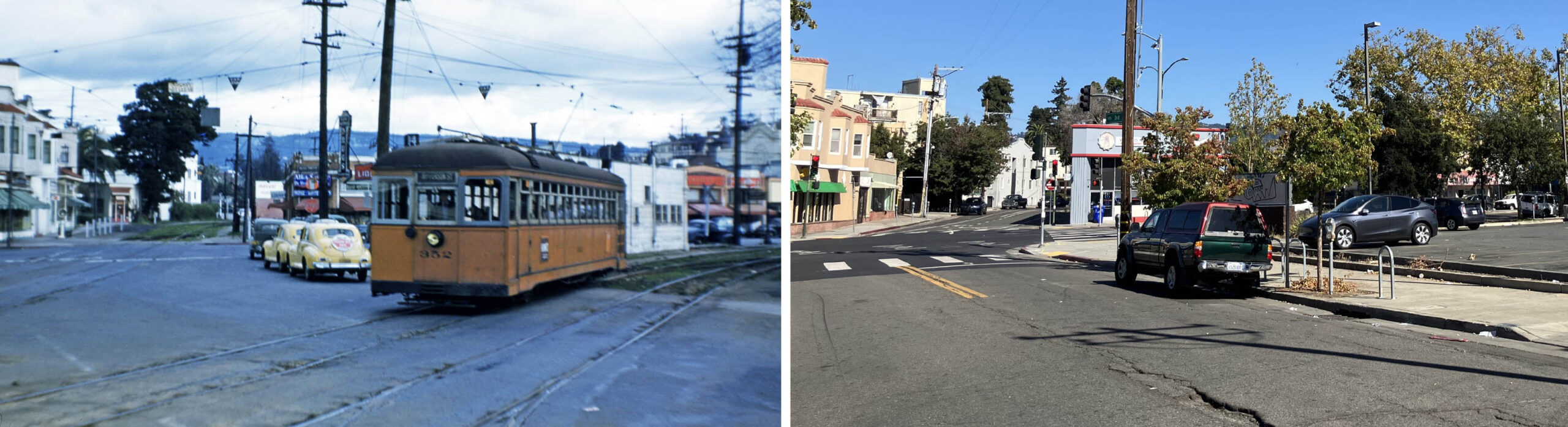
A before-and-after sequence in color provides greater contrast to what is seen in 2025. KS 352, Line 14 Line is seen at the cut on the last day of operation, Mar. 28, 1948. The image captures the 3rd St. Cut on the left edge, and the top portion of the Parkway Theater on the right.
L336-60-John Harder Collection, Courtesy John Harder, l, Stuart Swiedler Photo, r, (Image 14 of 43)
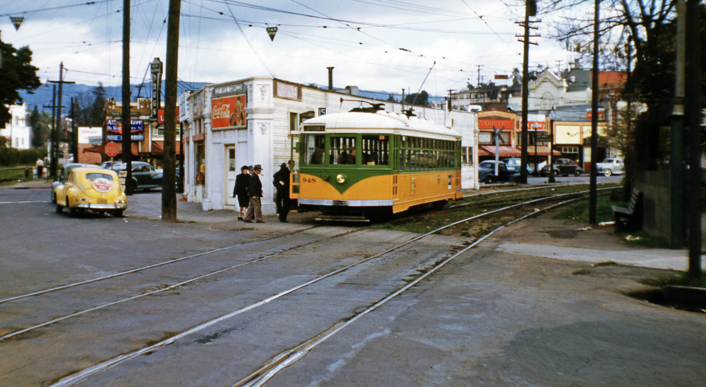
This northeast view of KS 948, Line 15 documents that the cut also served as a stop at 3rd Ave. before streetcars approached the car house.
L336-65-John Harder Collection, Courtesy John Harder, (Image 15 of 43)
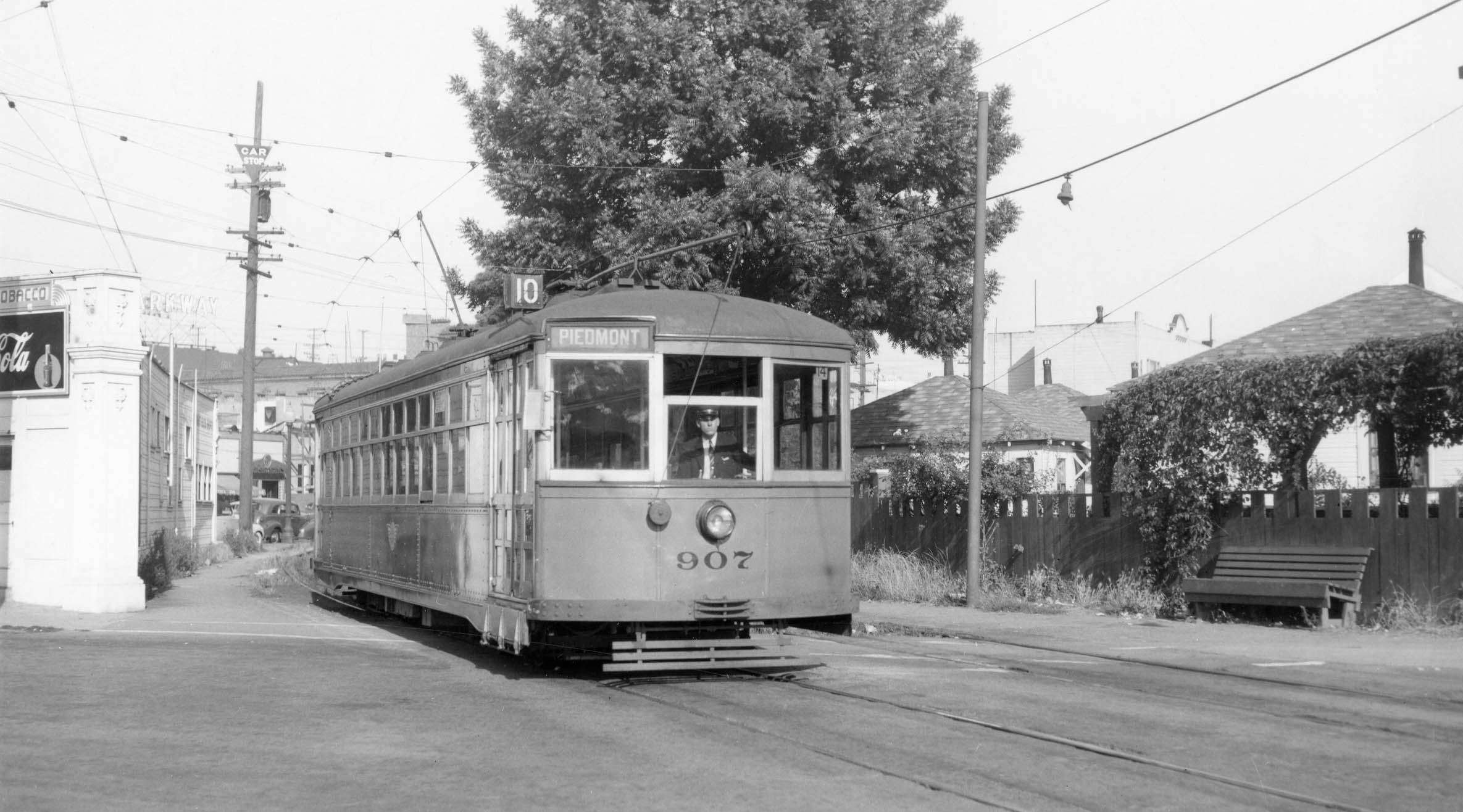
Another northeast view, here with KS 907, Line 10 ready to cross 3rd Ave. features another view of the 3rd Ave. Ct. cottages on July 9, 1941.
L336-70-Wilbur C. Whittaker Photo, Moreau Collection, Courtesy BAERA, Western Railway Museum Archives, 160966ks, (Image 16 of 43)
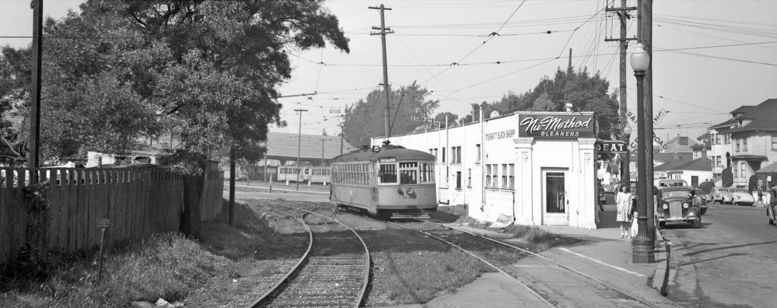
The rear of KS 947, Line 15 heading to the car house indicates that Nu-Method Cleaners occupied no. 311 E. 18th St. ca. 1946. This view also captures rarely seen private residences along the north side of E. 18th St. west of 3rd. Ave., seen along the right edge.
L336-75-Tom Gray Photo, Courtesy BAERA, Western Railway Museum Archives, 146713ks, (Image 17 of 43)
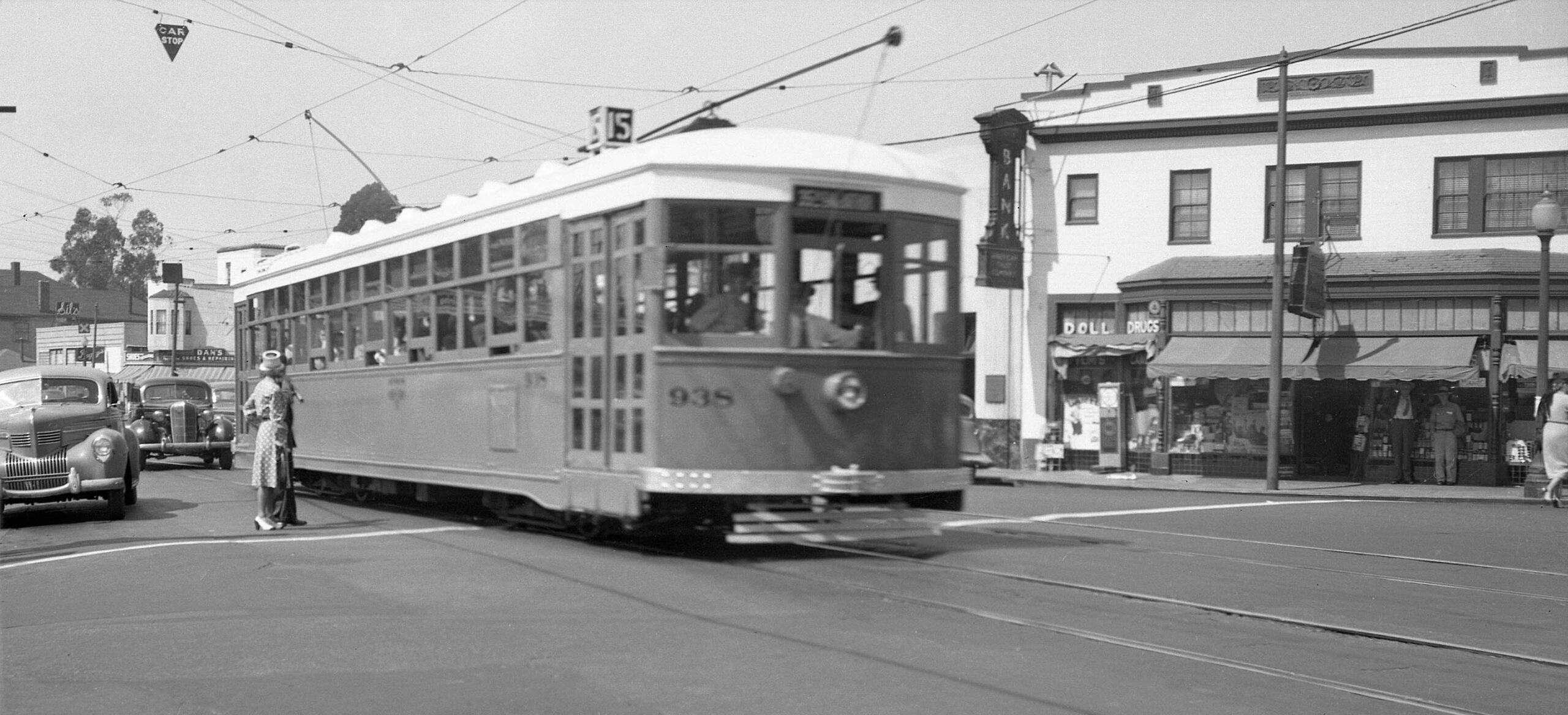
KS 938 line 15 is done with the cut and on E. 18th St. at the 4th Ave.-Park Blvd. divide ca. 1948. The building that curves around this corner, nos. 1801-1811 Park Blvd., with the decorative cornice and parapet, dates to 1923 (Permit no. 76931.) An American Trust Co. office is to the left at no. 350 E. 18th St. In the distance can be appreciated Dan’s Shoes and Baggy’s.
L336-80-Moreau Collection, Courtesy BAERA, Western Railway Museum Archives, 93133ks, (Image 18 of 43)
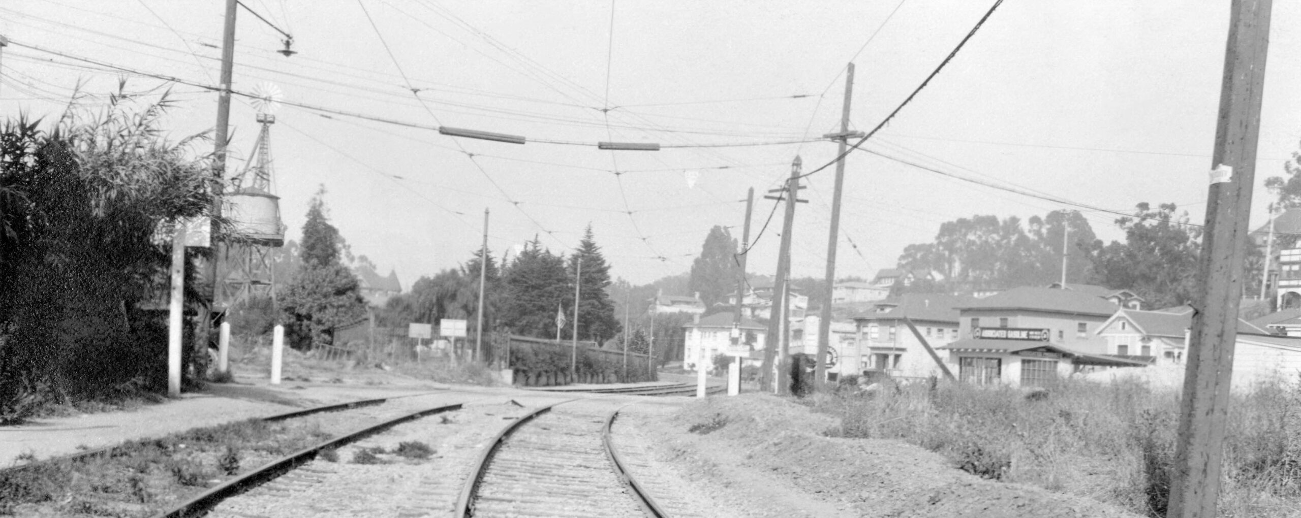
Documentation could not be found to establish the timeline of the usage and elimination of the E. 18th St. Cut once the KS tracks were removed. The aerial from 1958 shows a more squared- off version that appears to be paved, red arrow, center, as well as the 3rd. Ave. Cut, yellow arrow, center, that survives into 2025. The aerial from 1965, right, suggests the E. 18th Cut was eliminated close to the time when this image was taken, as well as elimination of many of the cottages to the east and south prior to any new building construction.
L336-82-Harrison Ryker Photo V5-142, Courtesy California Department of Transportation, l, but-1958_4v-78, c, cas-65-130_15-113, both Courtesy of UCSB Library Geospatial Collection, r, (Image 19 of 43)
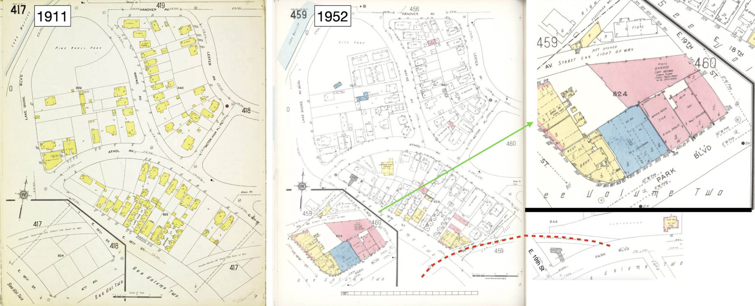
Next to the 3rd Ave. Cut. The Sanborn maps for this section of Oakland are oddly arranged, but this set of images documents that creation of the corridor for the Park Blvd.-bound streetcars did not remove any structures and was still in in open territory in 1911.
L336-85-Library of Congress, Geography and Map Div., Sanborn Maps Coll., Panel 206 from 1903 Vol 2, l, Panel 417 from 1911 - 1912 Vol. 4, r, (Image 20 of 43)
The cut from E. 18th St. to the entry onto Park Blvd. is shown in the Sanborn maps in the center and right from 1952. The insert on the top right shows the pedestrian way and the auto repair shop that no longer exist, while the one on the lower right shows the playground that was renamed Smith Park, to be discussed soon.
L336-90-Library of Congress, Geography and Map Div., Sanborn Maps Coll., Panel 417 from 1911 - 1912 Vol. 4, l, 459 from 1928 - Republished 1952 Vol. 4, c, 459-460, from 1928, Republished 1952 Vol. 4, r, (Image 21 of 43)
Side-by-side aerial views of the entire 3rd Ave. Cut from 1937 versus 2025 are displayed here. These aerials will serve as a second way to verify before-and-after ground views that follow. As one detail of interest, the pedestrian way that would allow access to the streetcar from Athol Ave.-Wayne Place is indicated by the red broken line, left, obliterated in 2025, right.
L336-95-Harrison Ryker Photo V5-142, Courtesy California Department of Transportation, l, and Google Maps, r, (Image 22 of 43)
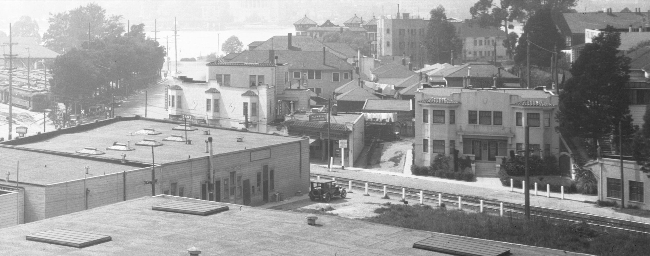
A second presumed, but not labeled, Eston Cheney west view with the car house, Lake Merritt, and the Oakland City skyline taken from the Parkway Theater ca. 1926-1927 provides a documentation of the southwest section of the 3rd Ave. Cut between E. 18th St. and E. 19th St.-Wayne Pl., shown in detail next.
L336-100-Cheney Photo, Sappers Collection, Courtesy BAERA, Western Railway Museum Archives, 223869ks, (Image 23 of 43)
Based on the listing from 1944 shown in L336-37, all the structures along the 3rd Ave. Cut seen in this detail were considered 3rd Ave. while the streetcar was active. Note the sidewalk ends at the small building on the right edge, diminutive Lake Lending Library to be discussed momentarily. Dan’s Shoes and Repairing at the corner of E. 18th St. is a Subway store in 2025, and the stores to the right marked with the plumbing sign are still in use as well. To the right is the multifamily-small apartment dwelling at no. 1815 (Permit no. A4926, ca. 1925.) The two structures just to the right of that are gone.
L336-105-Cheney Photo, Sappers Collection, Courtesy BAERA, Western Railway Museum Archives, 223869ks, Detail, (Image 24 of 43)
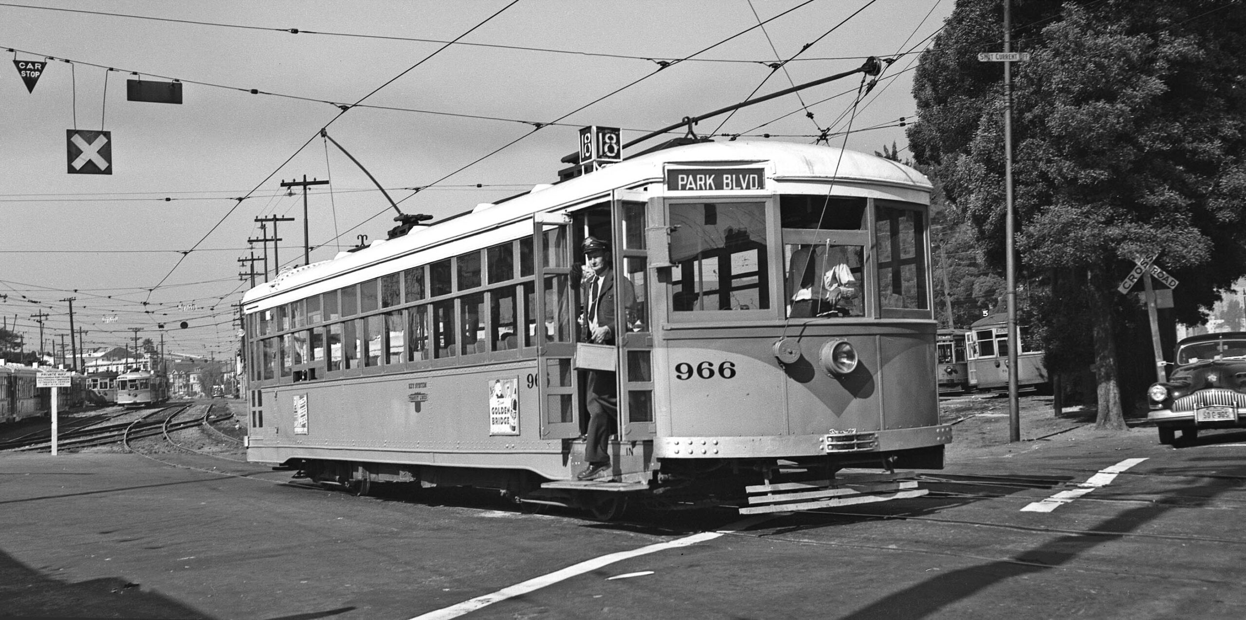
Next, a ride on Line 18 in the cut, as KS 966 waits to be boarded on E. 18th St., ca. 1948, southwest view. All pairings that follow will compare an image from the 1930s-1948 versus 2025.
L336-110-John Harder Collection, Courtesy John Harder, (Image 25 of 43)
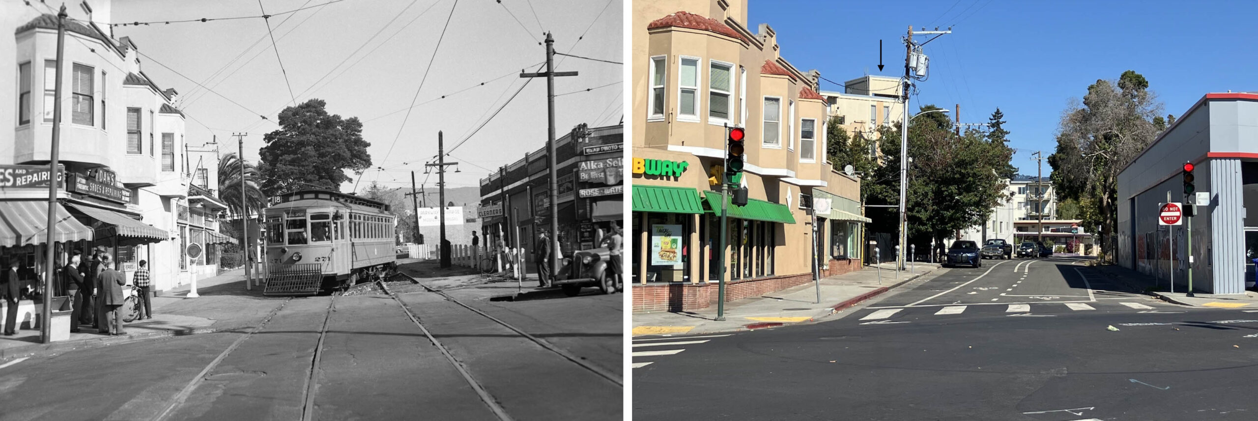
The first pair of images of the 3rd Ave. Cut to be reviewed show the southwest entry at E. 18th St. in a northeast view. On the left, KS 271 is shown on a Line 18 excursion on Nov. 21, 1948, one week prior to abandonment of the Central Car House and what remained of the KS streetcar system. The cut had not been in use for regular Line 18 service since that service was terminated on Mar. 28, 1948. The pairing contrasts the longevity of structures lining the north or left versus the south or right side of the cut.
L336-115-Walt Vielbaum Photo, Courtesy BAERA, Western Railway Museum Archives, 220127ks, l, Stuart Swiedler Photo, r, (Image 26 of 43)
The left panel shows a northeast view of the north side of the cut with KS 922, Line 18 at the 3rd Ave. at E. 18th stop boarding passengers on June 14, 1946. The image from 2025 reinforces that most of the north side of the cut hasn’t changed much since its heyday.
L336-120-Peter Kyhn Photo, Courtesy BAERA, Western Railway Museum Archives, 134086ks, Stuart Swiedler Photo, r, (Image 27 of 43)
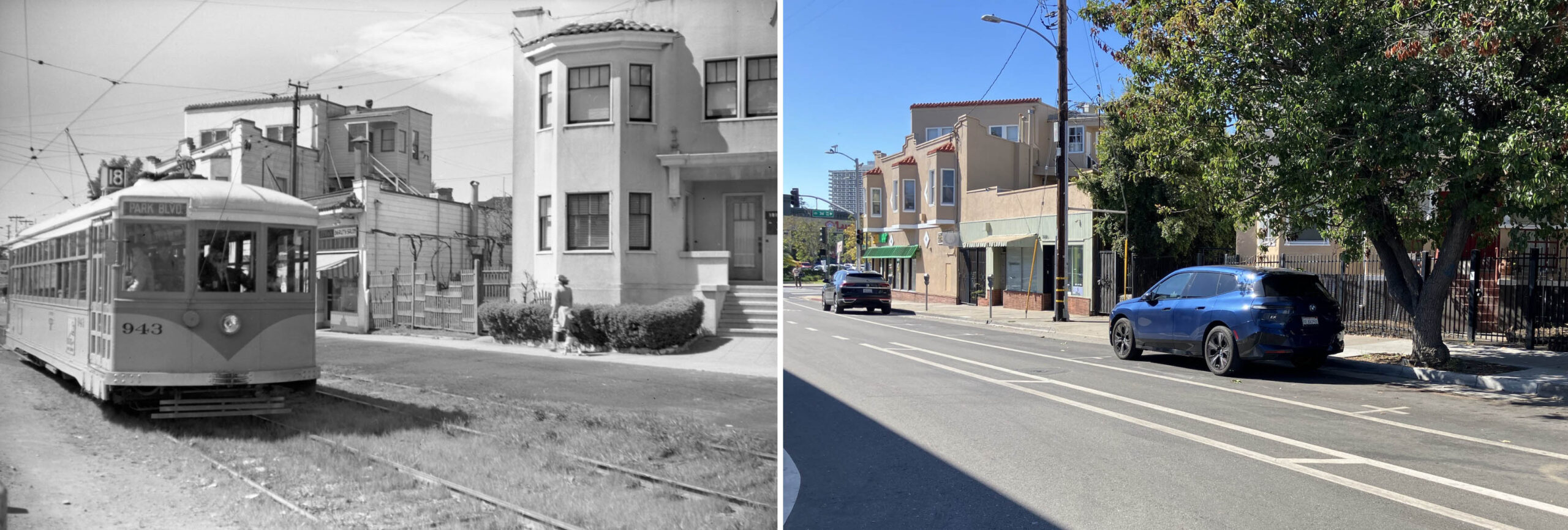
A southwest view of the initial part of the cut is featured with KS 943, Line 18 outbound between E. 18th and E. 19th St.-Wayne Blvd. in 1948. No ground image was found that showed the entire multifamily-small apartment dwelling at no. 1815 3rd Ave., and in 2025 the same view is obscured by a tree. The Beauty Shop sign, left, refers to Aileen’s Beauty Shop at no. 1809.
L336-125-Fred Matthews Photo, Moreau Collection, Courtesy BAERA, Western Railway Museum Archives, 97896ks, l, Stuart Swiedler Photo, r, (Image 28 of 43)
This pairing features KS 987, Line 18 still south of E. 19th St.-Wayne Blvd. in a northeast view during the lines final days in Mar. 1948. The structure to the right flank of no. 1815 with a large set of glass windows has since been replaced by a larger apartment building. In 2025, the persistence of two KS poles can be seen on the north side. Referring to the aerials in L336-95, the south or right side at this point was an open lot that has since been filled with a building extending all the way to E. 18th St., appreciated by the shadow it created in the image on the right.
L336-130-Arthur Lloyd Photo, Courtesy BAERA, Western Railway Museum Archives, 111986ks, l, Stuart Swiedler Photo, r, (Image 29 of 43)
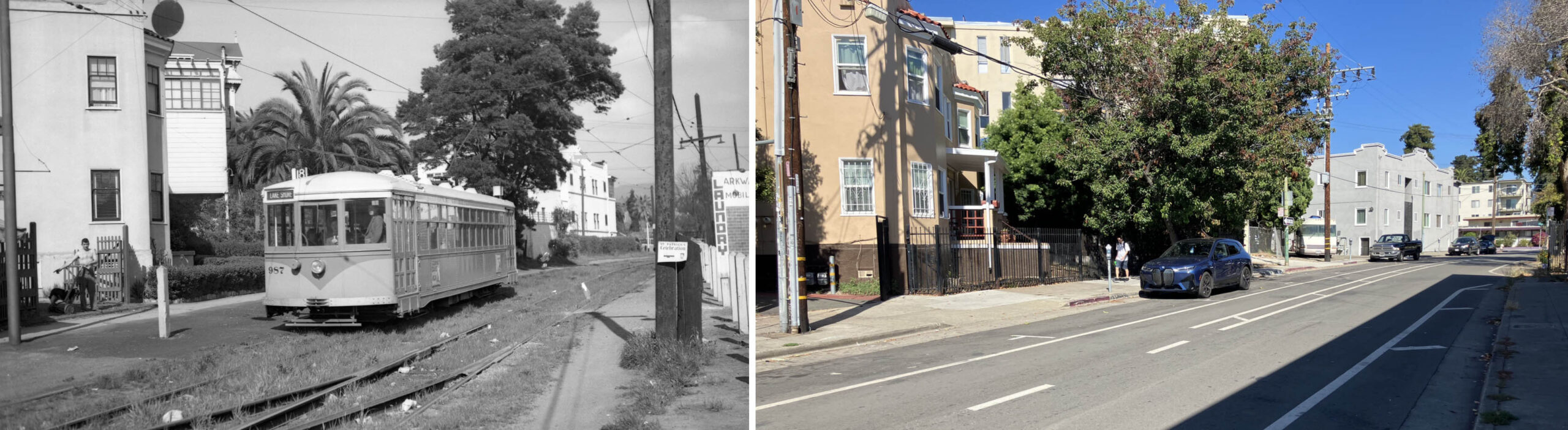
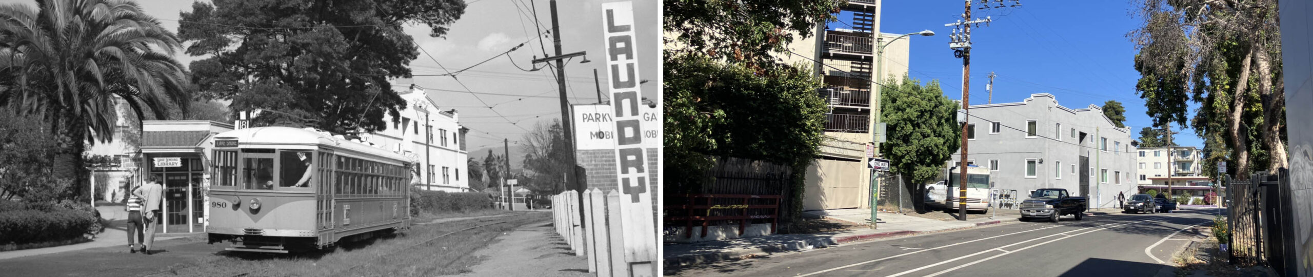
Two gems are revealed in this northeast view of KS 980, Line 18 inching closer to E. 19th St. on Mar. 21, 1948. On the left, observe the pedestrian way from Athol Ave.-Wayne Place, and to its right, the Lake Lending Library at no. 1825 3rd Ave. The origins of the library are not known, and it was not listed as part of the Oakland Public Library. Again, two KS poles survive in 2025, right. On the south side of the cut, left, the laundry sign seen in the last image is seen, as is the west wall of the Parkway Garage building.
L336-135-Fred Matthews Photo, Moreau Collection, Courtesy BAERA, Western Railway Museum Archives, 90278ks, l, Stuart Swiedler Photo, r, (Image 30 of 43)
A bonus of this image of KS 912, Line 18 sitting alongside the persisting white apartment building at nos. 321-331 Wayne Pl. in a northeast view is information about the Parkway Garage. Note that once past the library, there was no paved sidewalk and buildings were not entered onto along the cut, i.e., those structures were entered through Park Blvd. or Wayne Pl. The trees along the right edge in the right image line a parking lot in 2025.
L336-140-Richard Jenevein Photo, Courtesy BAERA, Western Railway Museum Archives, 172639ks, l, Stuart Swiedler Photo, r, (Image 31 of 43)
Images of the 3rd Ave. Cut prior to 1940 are rare, and so this northeast view just short of the E. 19th St-Wayne Pl. grade crossing from July 14, 1921 is special. Note the first iteration of the Associated Gasoline service station on the small triangular plot formed by the merge of the cut and Park Blvd. seen in the distance.
L336-145-Key VPO Official Photo, Sappers Collection, Courtesy BAERA, Western Railway Museum Archives, 78615ks, (Image 32 of 43)
Roy Healy documented both sides of the E. 19th St.-Wayne Pl. grade crossing in 1946. The top left shows KS 979, Line 18 outbound in a southwest view, and the top right KS 901, Line 18 inbound in the cut. The former shows how the Parkway Garage extendied all the way to this corner, a parking lot in 2025, and the latter shows the enlargement of the service station relative to the 1921 view, extended even further to the intersection in 2025 by the addition of another building adorned by graffiti seen in the right panel.
L336-150-Roy Healy Photo, Courtesy BAERA, Western Railway Museum Archives, 121733ks, top l , 121732ks, top r, Stuart Swiedler Photo, bottom, (Image 33 of 43)
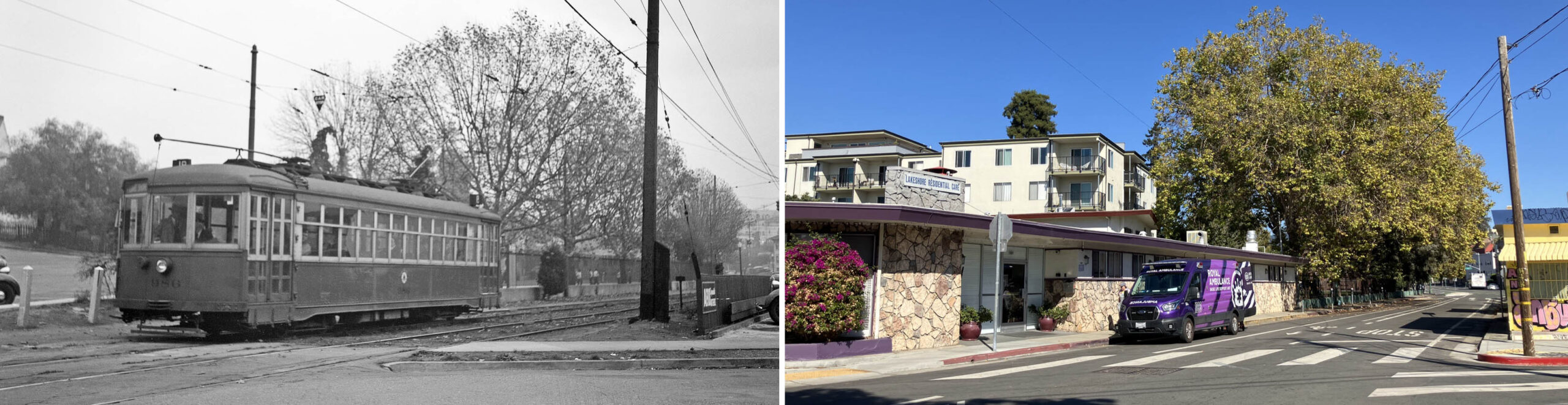
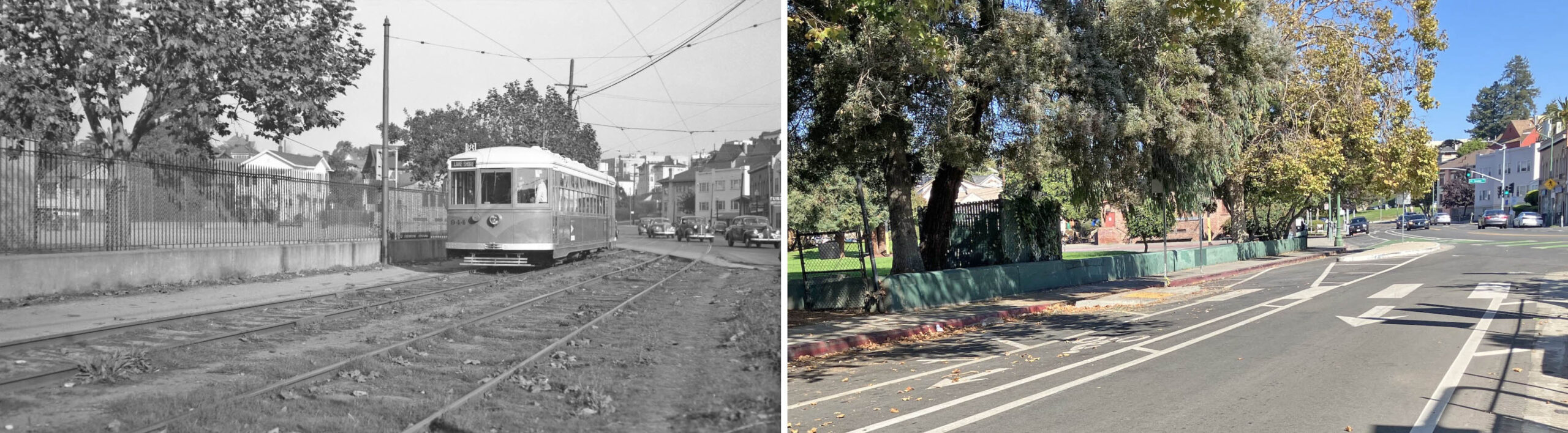
For the last section of the cut between E. 19th St.-Wayne Pl. and Park Blvd., this northeast view of KS 986 shows the park that extended along the north flank. In 2025, this is known as F. M. Smith Park, renamed from the Park Boulevard Recreation Center in 1969 to honor “Borax” Smith’s donation of the land for the park in 1912. A set of mules statues hauling borax was erected, as well as a descriptive plaque. The KS pole placed between the bush and the children playing in the park is still there in 2025, but tree cover obscures it if viewed from a distance.
L336-155-John Harder Collection, Courtesy John Harder, l, Stuart Swiedler Photo, r, (Image 34 of 43)
This northeast view of KS 919, Line 18 from Feb. 26, 1948 also shows that the park had once extended to the intersection, the last part serving as a parking lot. In 2025, this spot is filled with several structures as seen on the right. Prior to 1942, the original recreation center structure was occupied by the Park Boulevard Clubhouse, a popular site for weddings, meetings, lectures and entertainment, dating back based on newspaper accounts to 1914. The original building permit or an image of that building could not be found.
L336-160-Robert L. Stein Photo, Courtesy BAERA, Western Railway Museum Archives, 46109ks, l, Stuart Swiedler Photo, r, (Image 35 of 43)
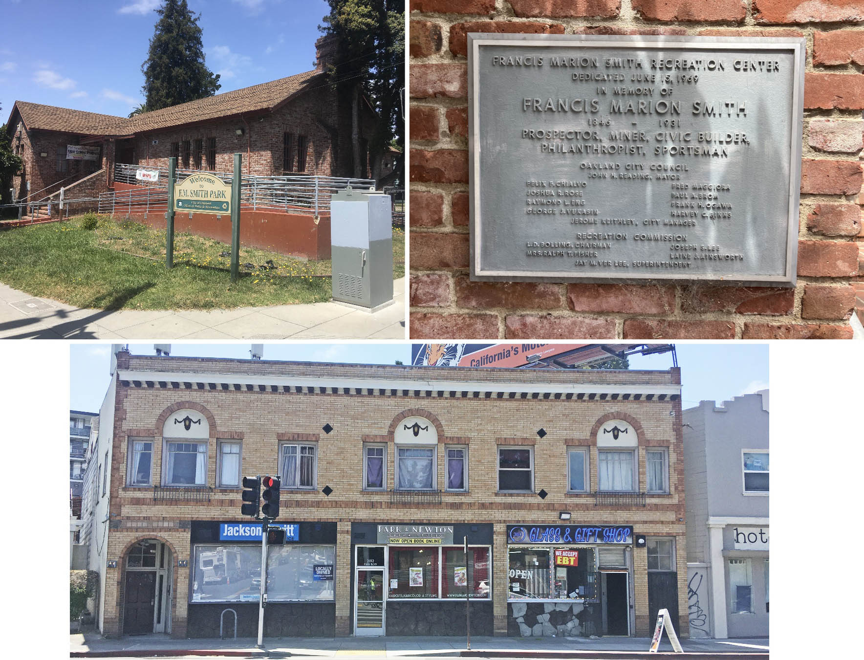
KS 944, Line 18 enters the cut off Park Blvd. in 1947, northeast view. The recreation center, coincidently no. 1969, seen in both images at the corner of Newton Ave. caters to young and old and has a computer lab and kitchen inside. The structure observed partially obscured in the distance is from 1942, when the Oakland Recreation Department dedicated a completely remodeled structure financed with funds from the Works Progress Administration, WPA. See the next image for a better view.
L336-165-Tom Gray Photo, Courtesy BAERA, Western Railway Museum Archives, 146717ks, l, Stuart Swiedler Photo, r, (Image 36 of 43)
A west view of the recreation center from 2024 is shown on the top left, the plaque marking its renaming on the top right. Aside from Borax Smith, railway connections also exist for the architect who designed the building across from the end of the cut at nos. 2010-2016 Park Blvd. with its fine brick work, mouldings, and masonry constructed in early 1925 (Permit no. 95804, 09/10/1924.) Architect Clay Burrell, who designed many commercial and apartment buildings in Oakland, including the California Hotel and the Lyons building, also converted the exterior of the former car and power house for the Consolidated Piedmont Cable Car Company to the Cox Cadillac Showroom, today Whole Foods Market at Harrison St. and Bay Pl.
L336-170-Stuart Swiedler Photos, (Image 37 of 43)
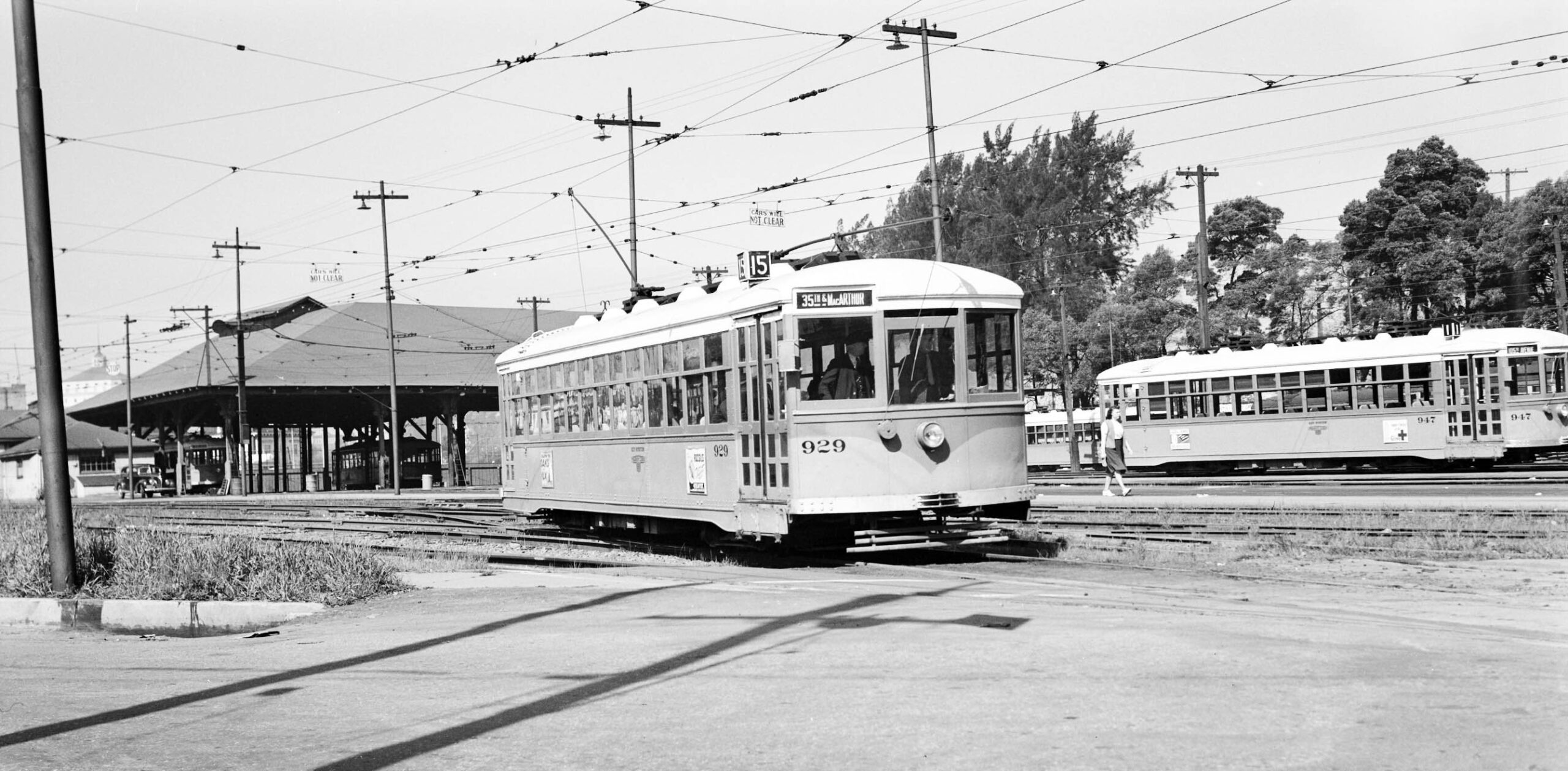
To finish, a few Central Car House images taken more from the northeast side of the facility. KS 929, Line 15, sets off for the E. 18th St. Cut in 1947.
L336-175-John Harder Collection, Courtesy John Harder, (Image 38 of 43)
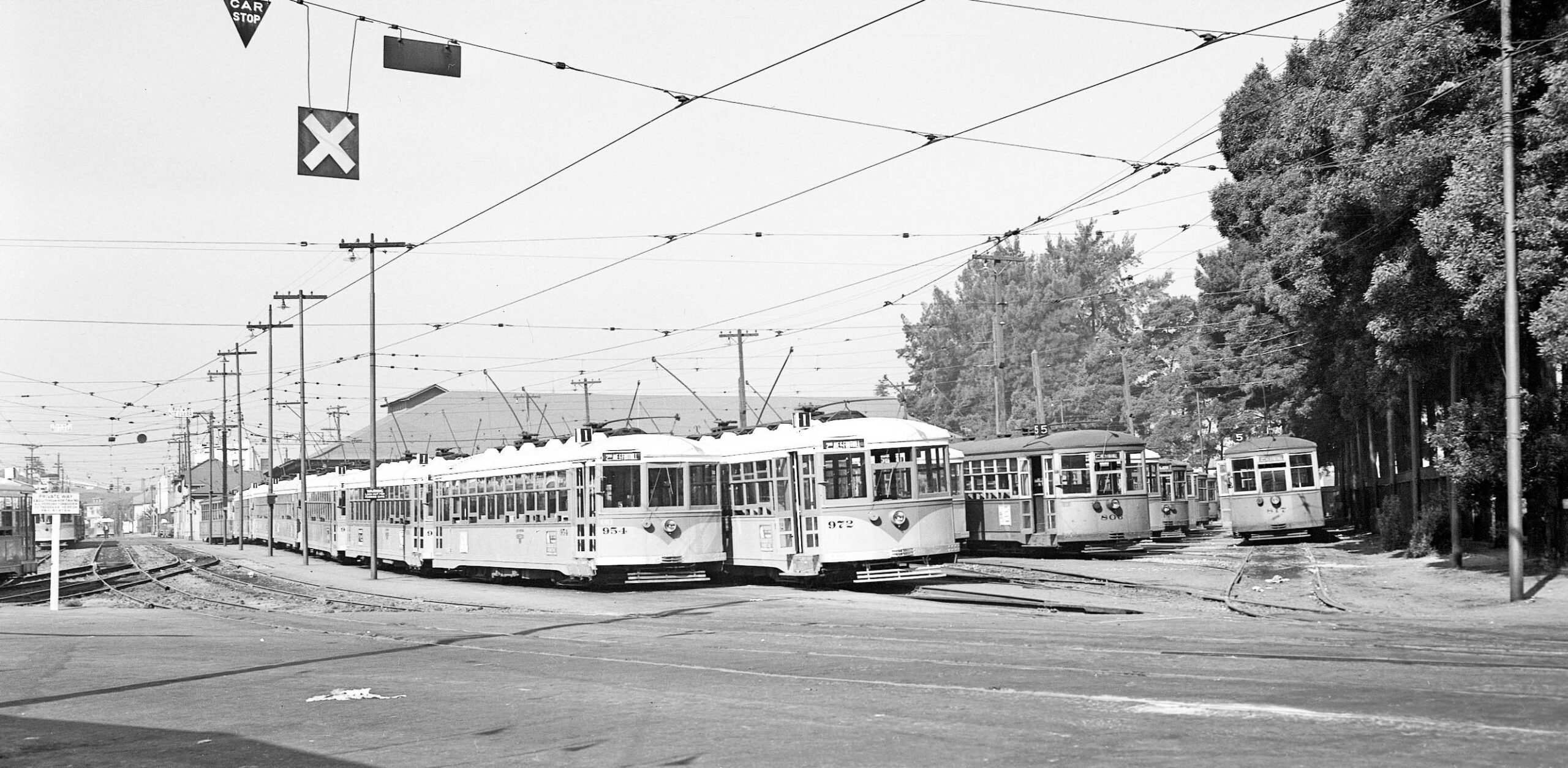
Next, a southwest view of the yard full of streetcars in 1948.
L336-180-John Harder Collection, Courtesy John Harder, (Image 39 of 43)
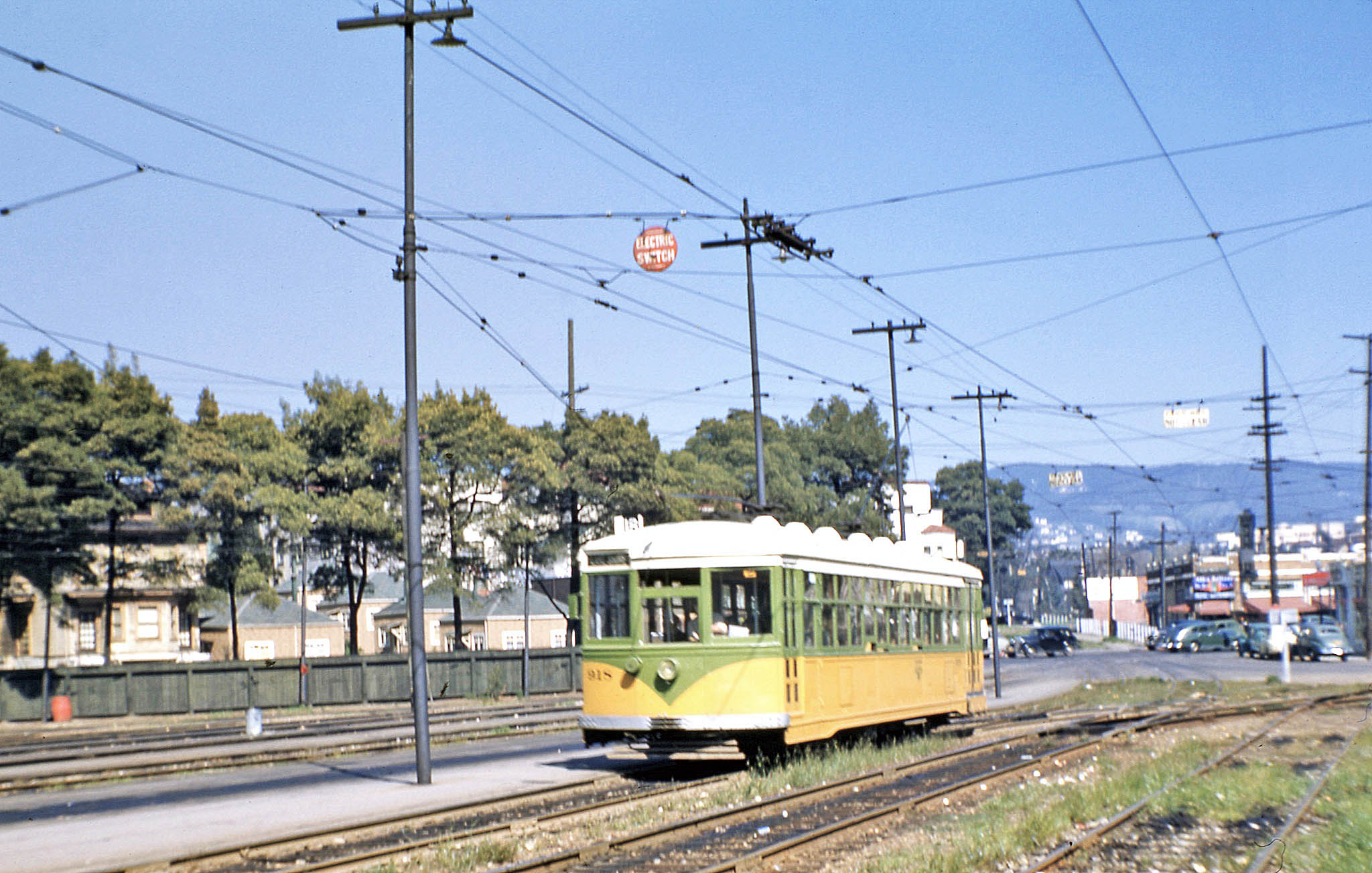
KS 918, Line 18 heads into the Central Car House grounds on its last day of operation, Mar. 28, 1948, a northeast view in living color.
L336-185-John Harder Collection, Courtesy John Harder, (Image 40 of 43)
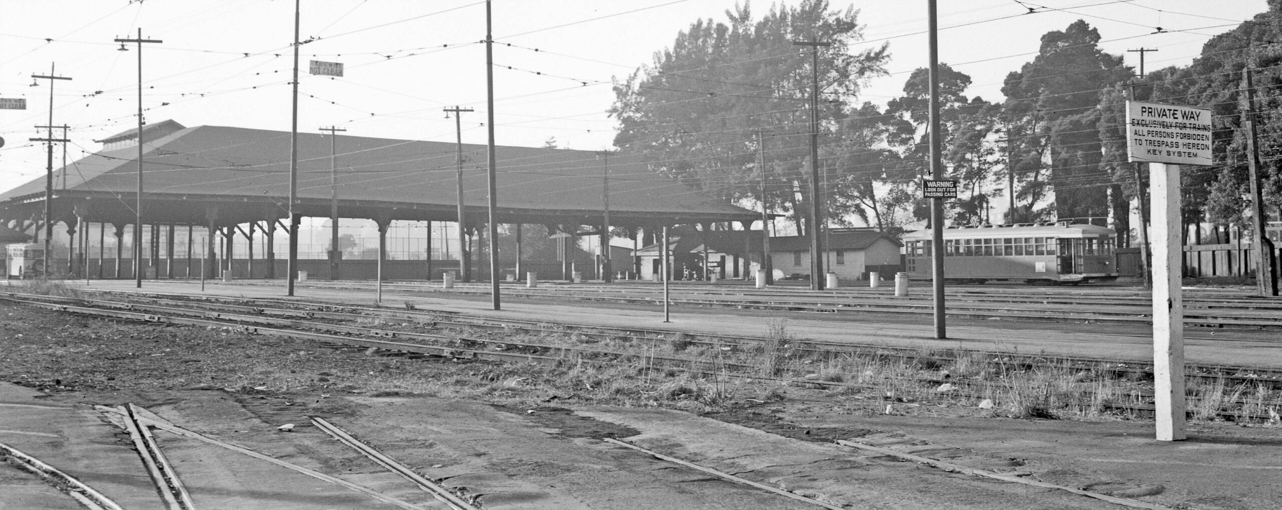
A west view of the Central Car House document that the tracks to the E. 18th Cut were abandoned and truncated in Sept. 1948.
L336-190-John Harder Collection, Courtesy John Harder, (Image 41 of 43)
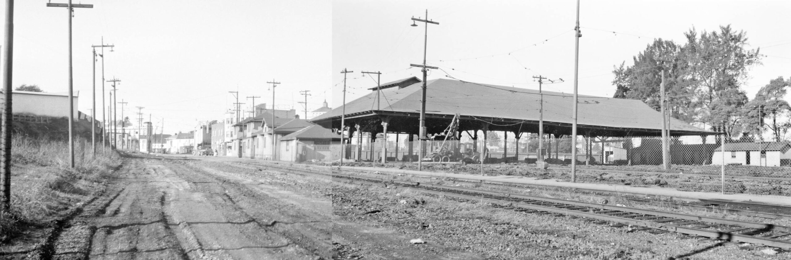
The date is Jan. 2, 1949, and KS employee Peter Kyhn took two images of the Central Car House to create a panorama documenting the abandonment of all streetcar service and this facility as well in Nov. 1948.
L336-195-Peter Kyhn Photos, Courtesy BAERA, Western Railway Museum Archives, Fusion of 134412ks, l, 134411ks, r, (Image 42 of 43)
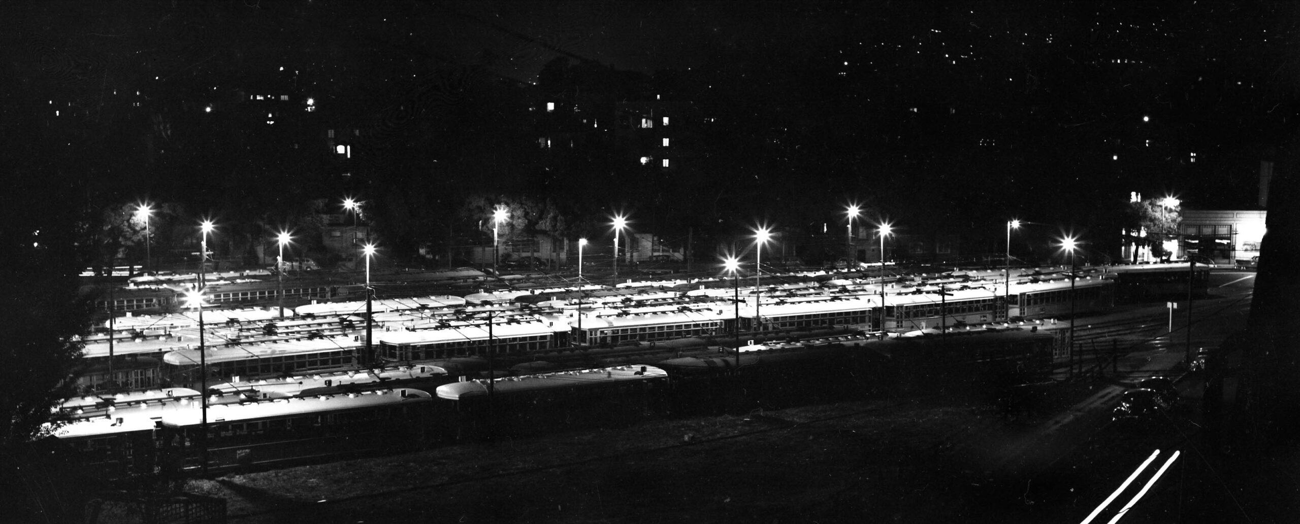
Time to put this presentation to bed with this north view of the car storage area close to the time of abandonment. Appreciation to John Harder for the many images provided from his collection, and to Betty Marvin of the Oakland Cultural Heritage Survey for the information about no. 238 Foothill Blvd. and several of the structures shown in this presentation.
L336-200-Vic DuBrutz Photo, Courtesy BAERA, Western Railway Museum Archives, 63688ks, (Image 43 of 43)