Spur of the Moment – Who’s on B Street?
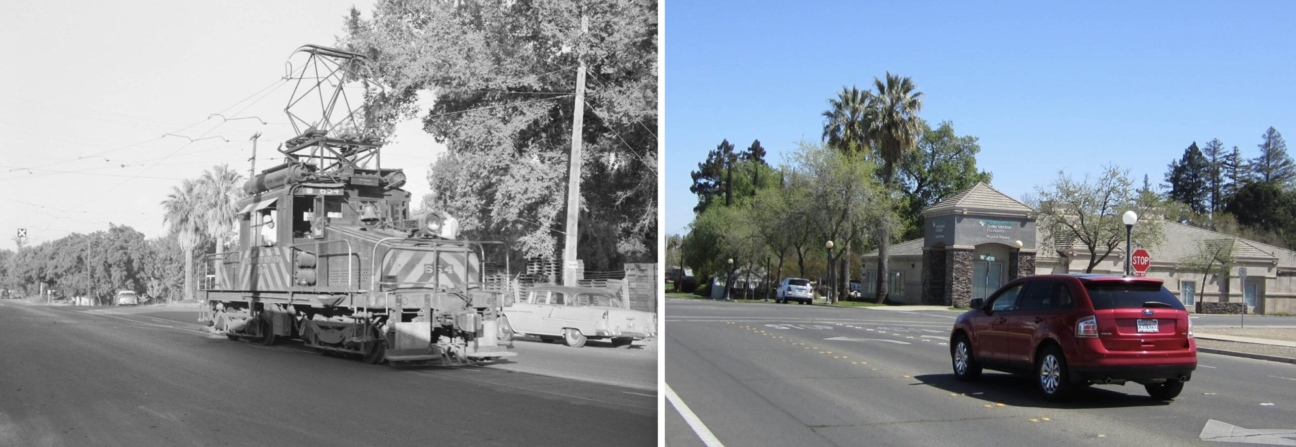
On the left, Norman Rolfe’s Aug. 2, 1959 east view features SN 654 at the spur supplying National Ice and Cold Storage Co., “National Ice”, and DiGiorgio Fruit Co., “DiGiorgio”, on B St. It was the only image found of a Sacramento Northern, SN, freight motor or diesel on B St. during the electric era in Yuba City. The “X” seen in the background appeared just east of a second spur to the same facilities. On the right, the same scene in Mar. 2021. This update will provide what is known and what has been difficult to establish of the freight customers on this stretch.
L307-05-Norman Rolfe Photo, Courtesy BAERA, WEstern Railway MUseum Archives, 53776sn, l, and Stuart Swiedler Photo, r, (Image 1 of 34)

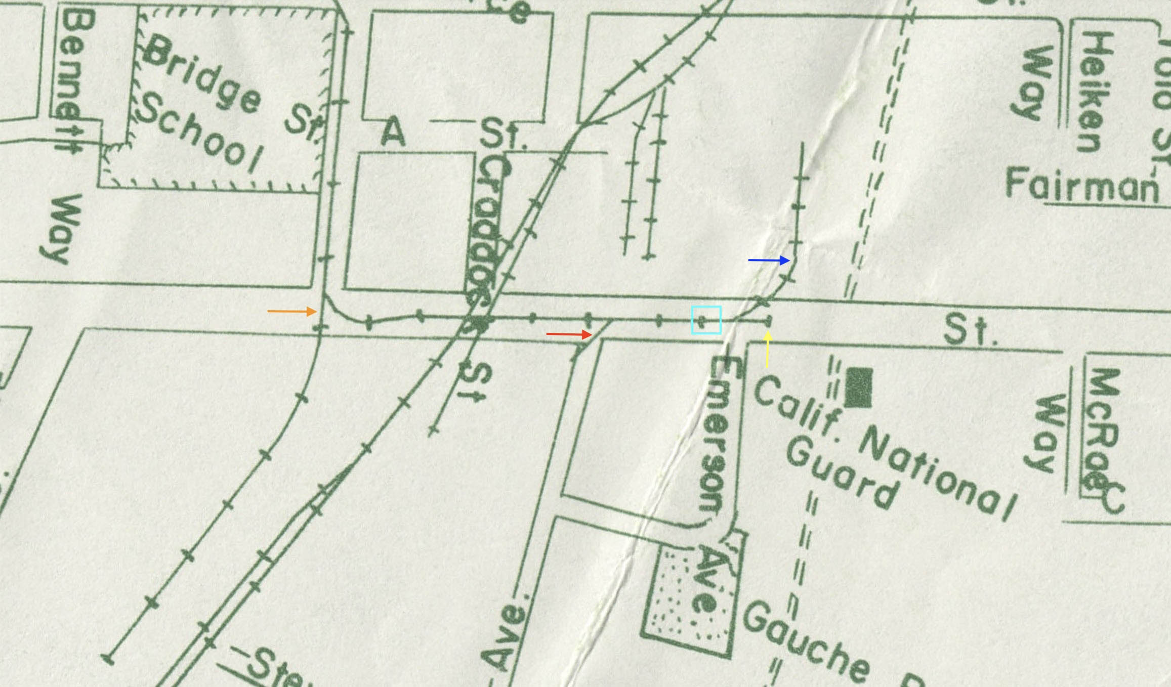
This map from 1960 provides, in part, context to the previous image. SN 654 in the previous image is positioned where the turquoise square is located, the spurs, blue arrow, and the end of the line, yellow arrow. The orange arrow points to the main California Packing Co., CalPak, spur reviewed in the last update, while the red arrow points to a short branch off Wilbur Ave. The spur to Rosenberg Bros. is not shown. The documentation of the SN spurs will be dealt with next. Ref: G4364 Y8 1960 S8 Case D
L307-10-Courtesy Earth Sciences and Map Library, University of California, Berkeley, (Image 2 of 34)
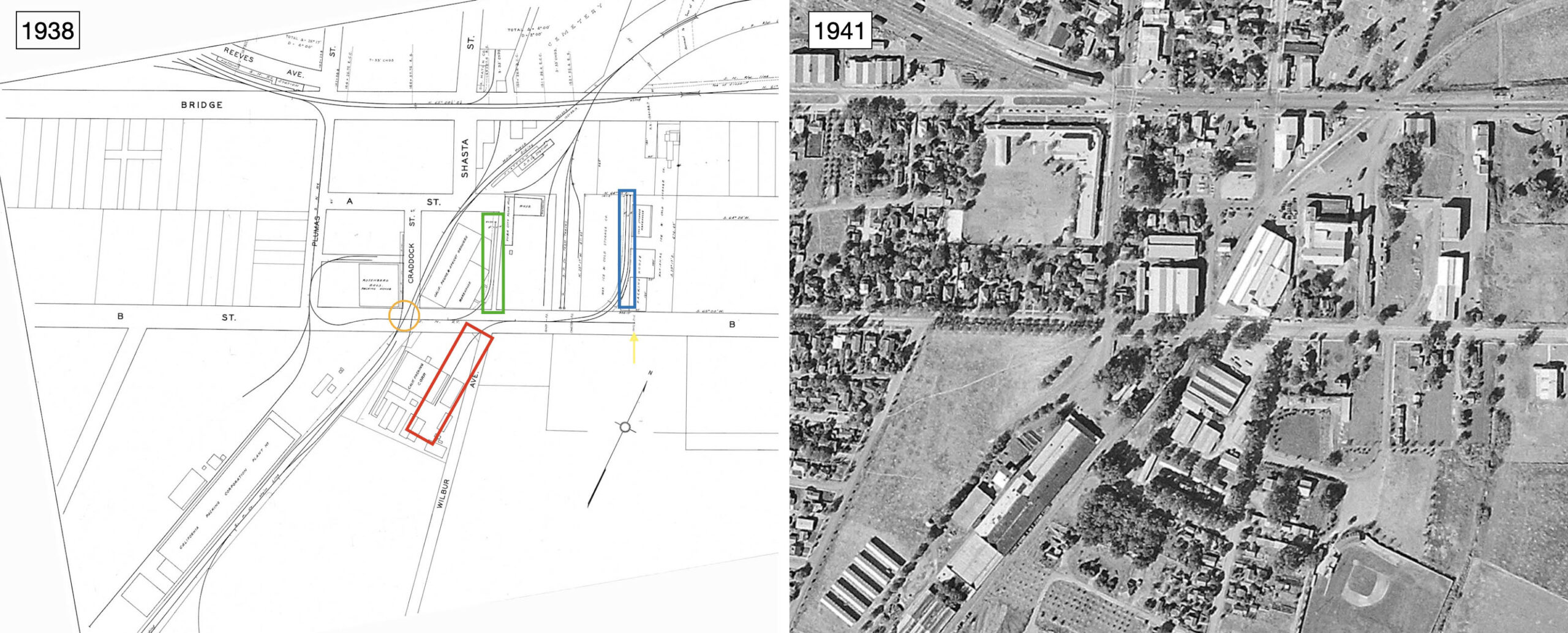
Relative to the map from 1960, this dual diagram-aerial just prior to WWII shows a longer spur across Wilbur Ave. that is supplying a second portion of CalPak, red box. The green box encloses a spur along California Prune and Apricot Growers, known to all as “Sunsweet”, that extends to A St. Note the two spurs to National Ice and DiGiorgio. The Southern Pacific, SP, crossing is circled in brown. Attributions: Left, Courtesy BAERA, Western Railway Museum Archives, 28; Right, Courtesy of UC Santa Barbara Library Geospatial Collection c-7490_455
L307-15- Multiple Attributions, (Image 3 of 34)
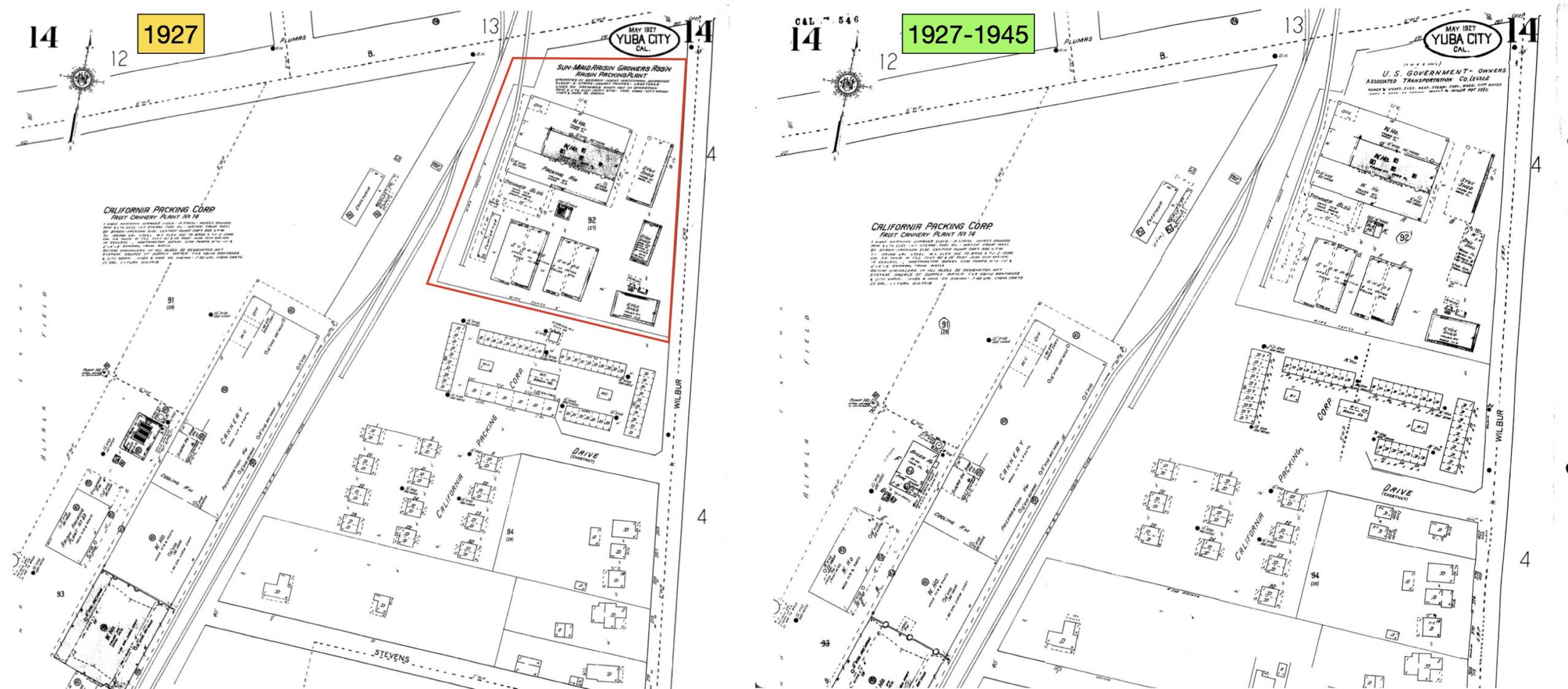
The 1927 Sanborn map and an updated version from 1945 displaying the south side of B St. show the transfer of Sun-Maid Raisin Growers Assoc., left, boxed in red, to Associated Transportation Co., right, the latter leasing the space from the U. S. Government. SN spurs are not included in these maps, so they do not address whether the SN had sent a second spur to the eastern-most facility of CalPak, boxed in red in L307-15.
L307-20-Sanborn Maps, Courtesy Sutter County Museum, (Image 4 of 34)
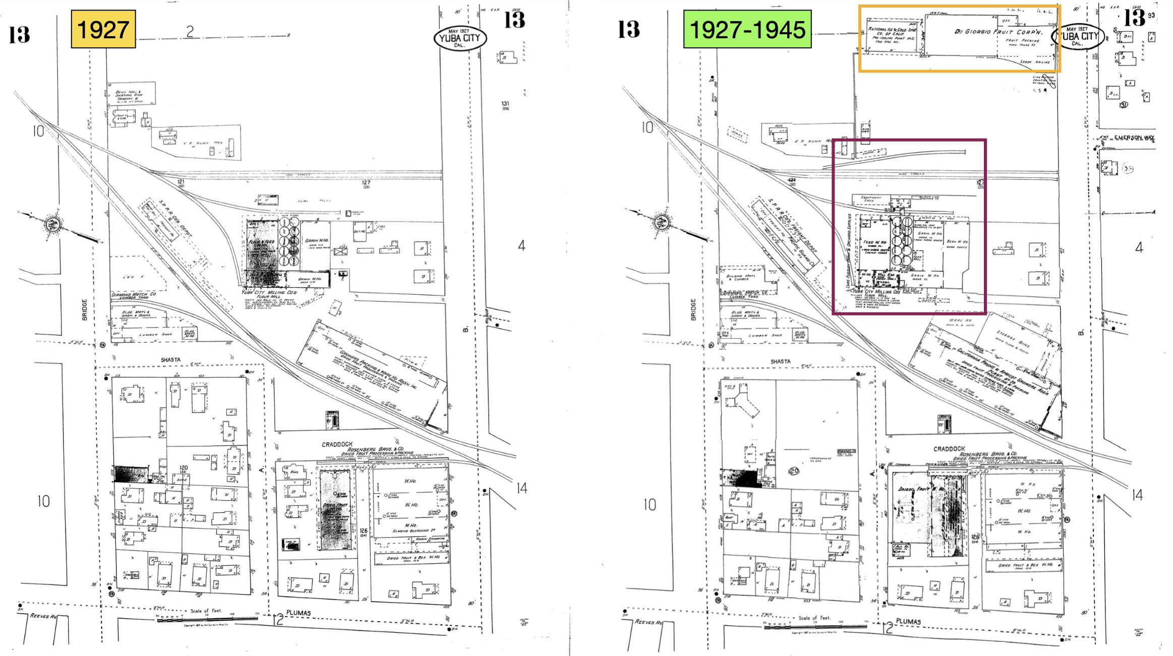
The corresponding Sanborn maps displaying the north side of B St. are shown here, these maps rotated showing B St. running top-to-bottom relative to the previous maps. The updated map, right, establishes that the buildings housing National Ice and DiGiorgio on B St. were added after 1927, enclosed within the orange rectangle. Some added complexity by 1945 is also shown of the SP spurs, enclosed in purple, for which there is no photographic documentation.
L307-25-Sanborn Maps, Courtesy Sutter County Museum, (Image 5 of 34)
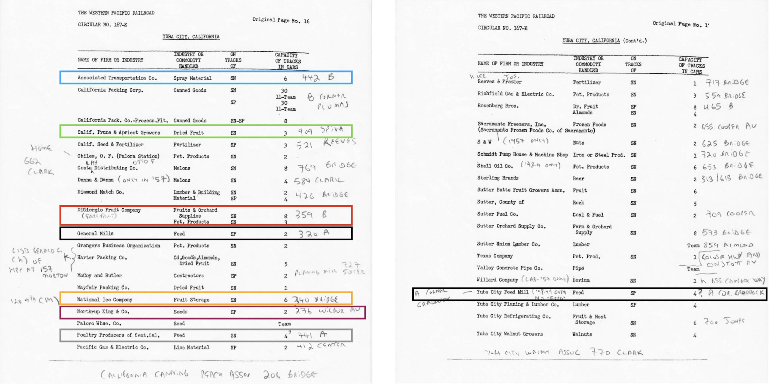
The businesses of interest for this update have been enclosed by colored boxes in this address-annotated Western Pacific Circular No. 167-E ca. 1957. Recall that although Rosenberg Bros. was listed as 465 B St. during this time period, the SN spur entered from A St. and was covered in the last update. No ground images of the SP spurs to the respective locations were found, so no further details can be provided on those locations other than from aerial views provided.
L307-30-Courtesy Bruce Eldridge, Annotated by Stuart Swiedler, (Image 6 of 34)
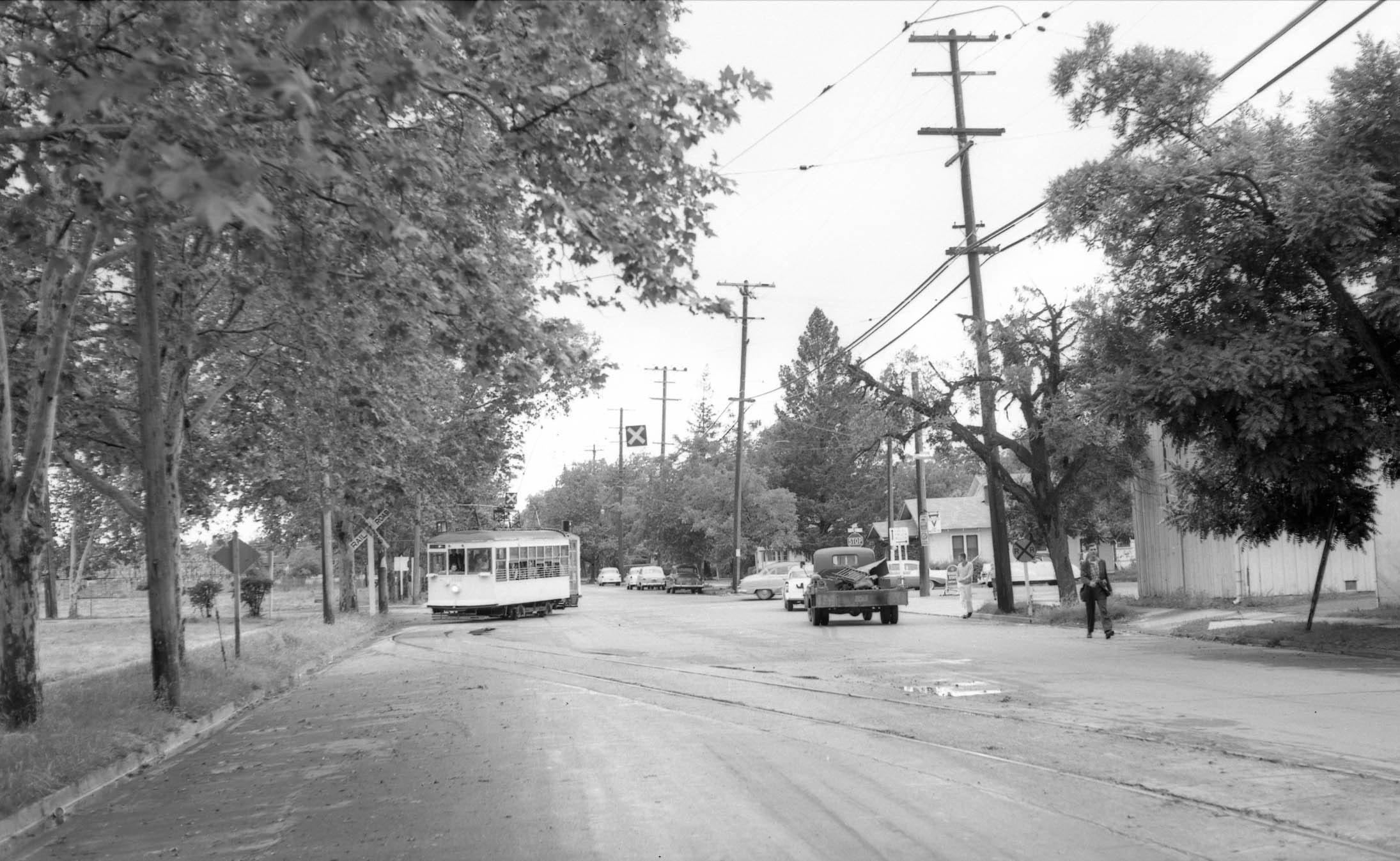
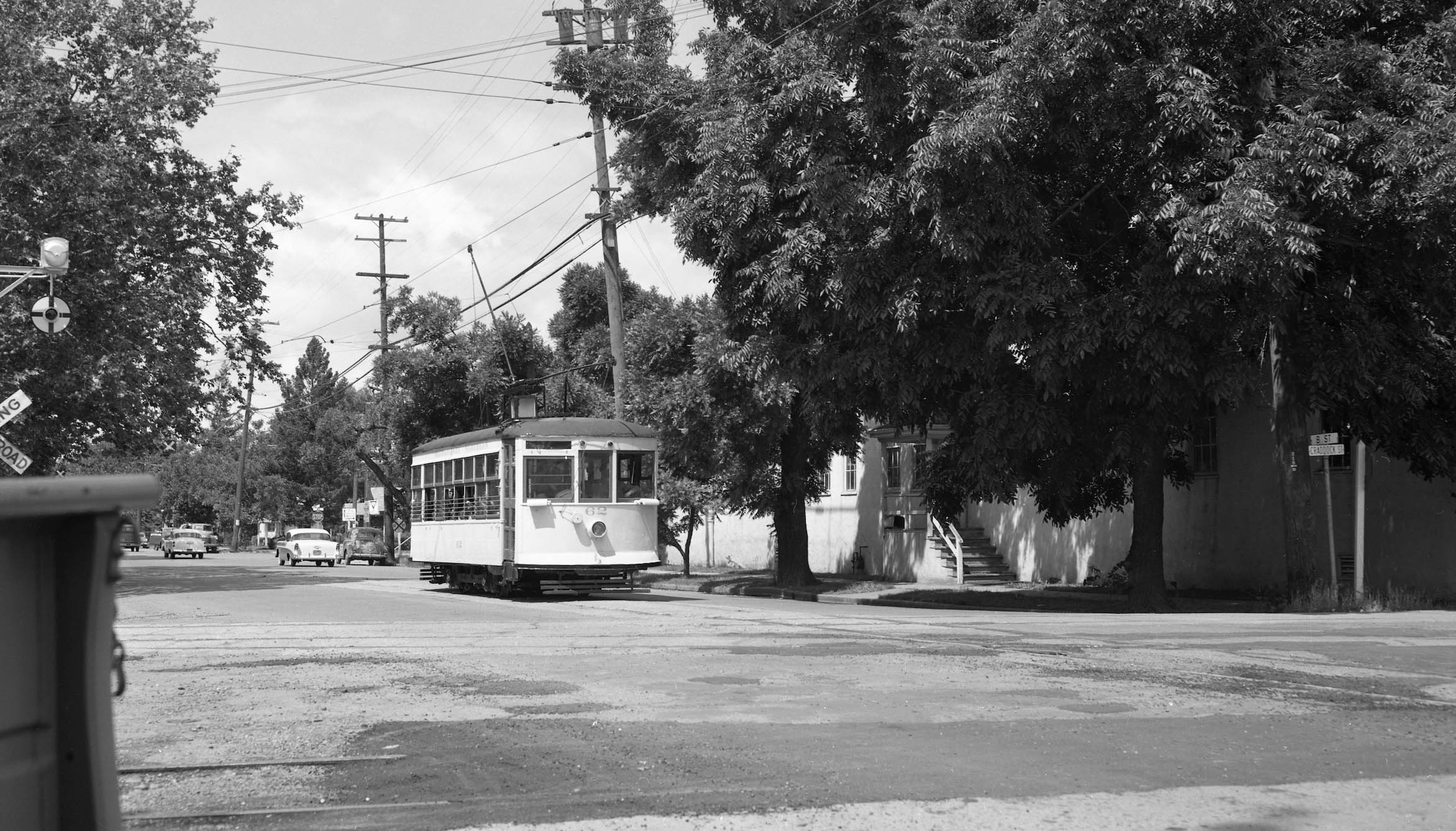
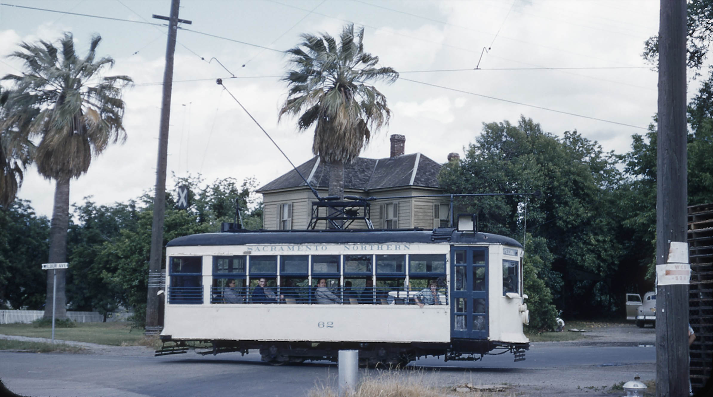
The last update ended with Birney 62 making the wide left turn from Plumas St. onto B St., as shown in this southwest view from the BAERA-sponsored excursion on the cloudy late afternoon of May 18, 1957.
L307-35-Walt Vielbaum Photo, Courtesy BAERA, Western Railway Museum Archives, 133540sn, (Image 7 of 34)
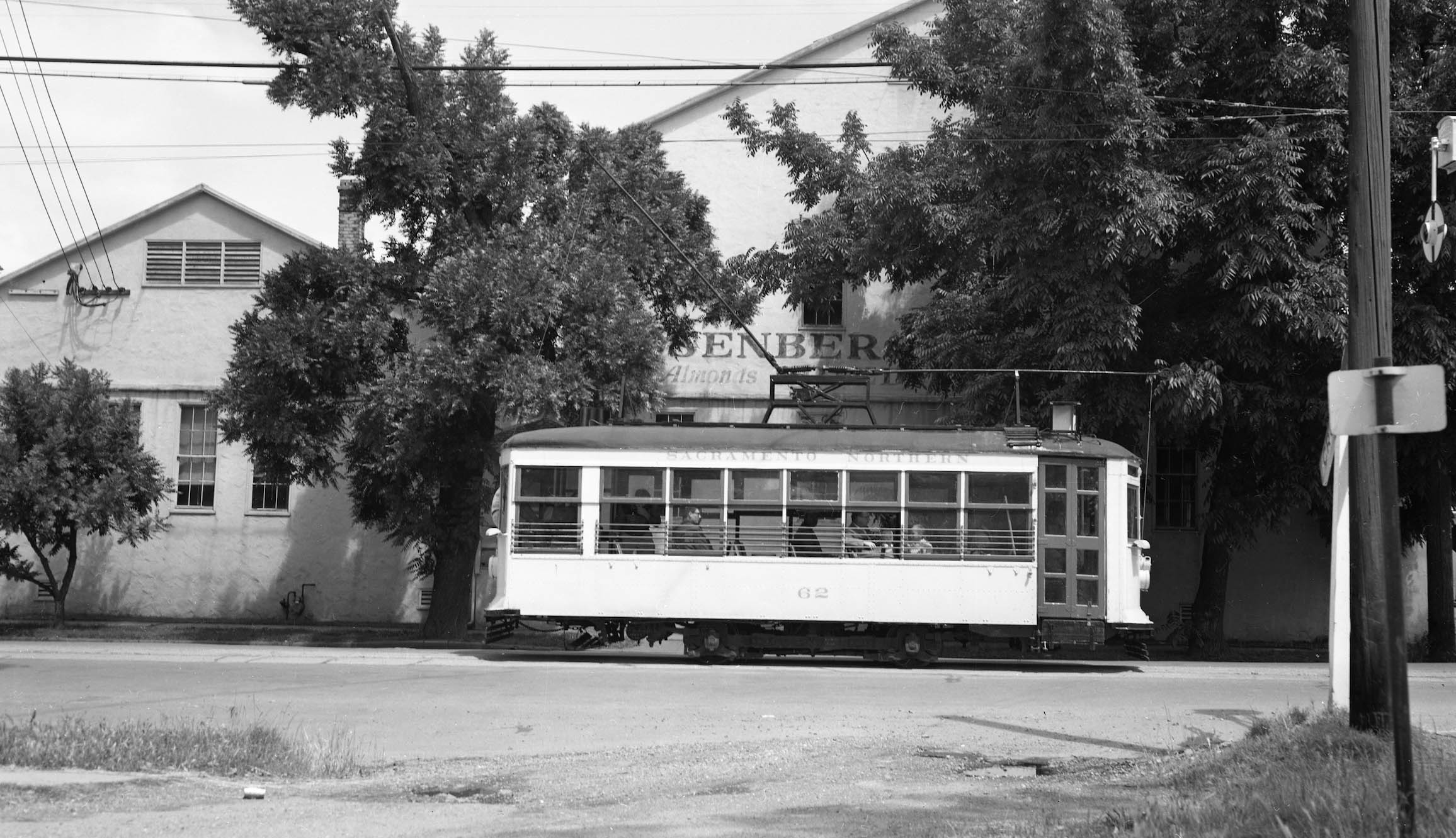
The sun was out of the following day for the excursion on May 19, 1957, and activities started early with Birney 62. The ride east on B St. between Plumas St. and Craddock St. provided an opportunity to document the Rosenberg Dried Fruits and Almonds sign on the Rosenberg Bros. warehouse. Note the wigwag signal being approached on the right edge.
L307-40-Addison Laflin Photo, Courtesy BAERA, Western Railway Museum Archives, 172985sn, (Image 8 of 34)
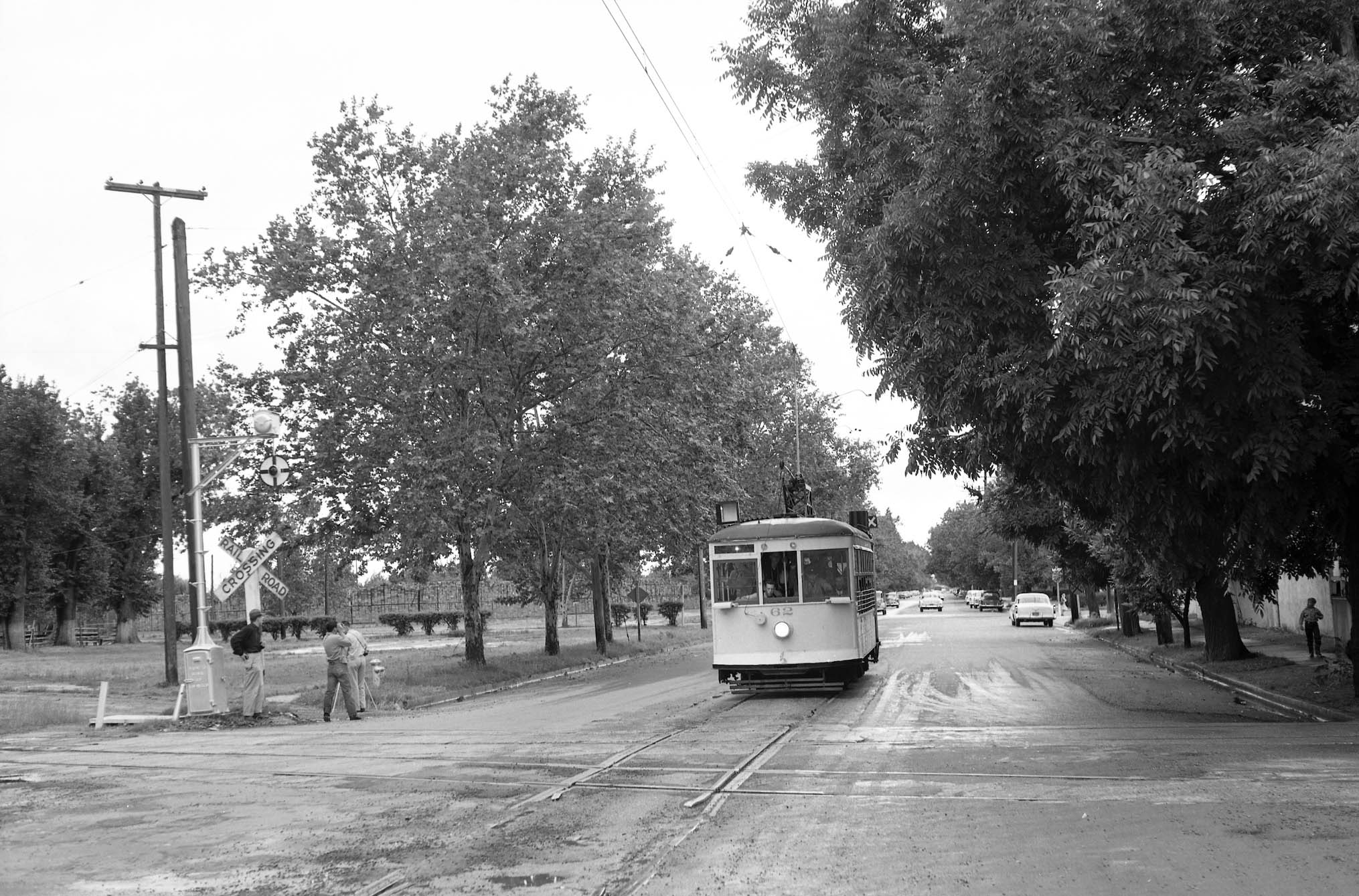
A southwest view from the day earlier captured Birney 62 making the mandatory stop before crossing the SP mainline and siding at Craddock St., May 18, 1957. The complementary view of the north side of the street is shown next.
L307-45-Walt Vielbaum Photo, Courtesy BAERA, Western Railway Museum Archives, 133537sn, (Image 9 of 34)
Taken one day later, a west view of Birney 62 at the SP crossing at B St. and Craddock St., showing the corner entrance to Rosenberg Bros. One note to railfans based on reviewing hundreds of this photographers images, Addison Laflin was particularly effective at including street signs in his images.
L307-50-Addison Laflin Photo, Courtesy BAERA, Western Railway Museum Archives, 172986sn, (Image 10 of 34)
Very similar to the last image, this west view at the SP crossing of Birney 62 on the May 19, 1957 taken by Vic DuBrutz was too a good a shot to not include in this presentation.
L307-52-Vic DuBrutz Photo Courtesy BAERA, Western Railway Museum Archives, 215230sn, (Image 11 of 34)
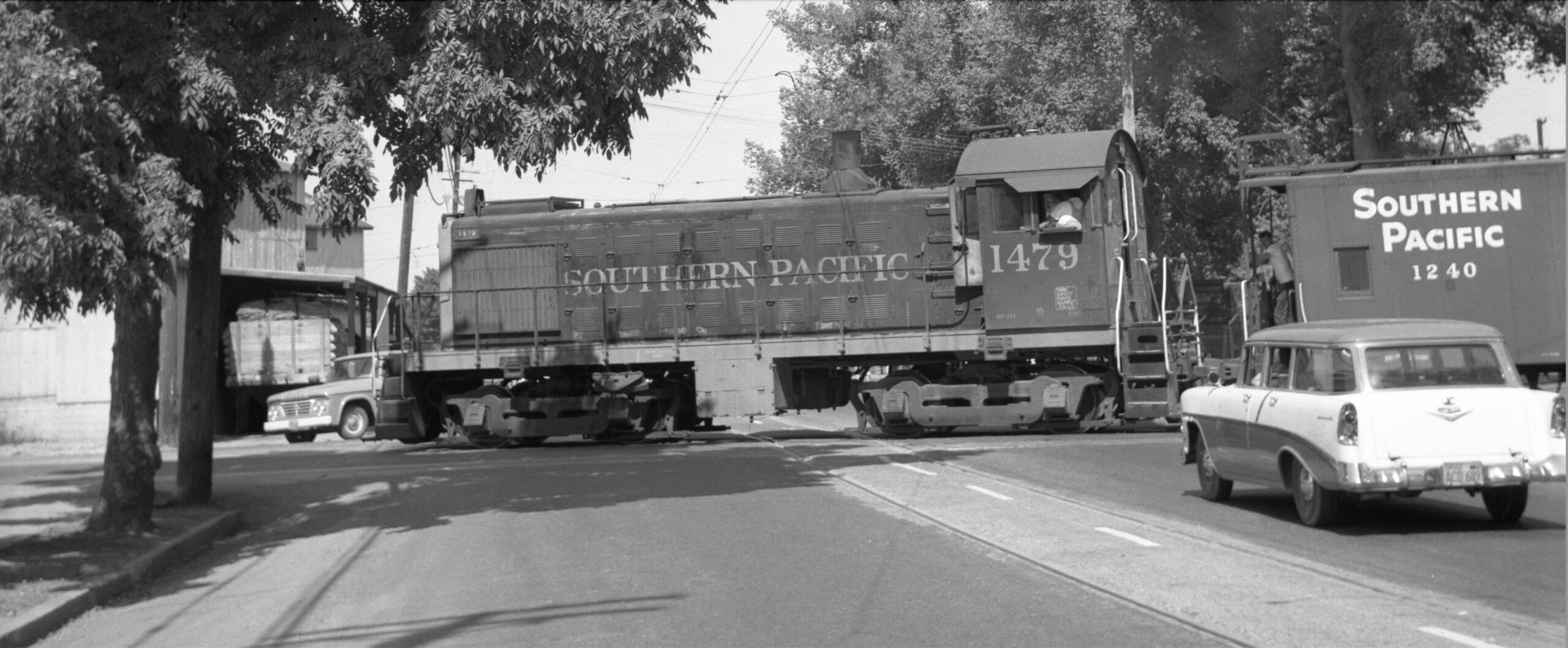
Tony Perles was in position to photograph SP ALCO S4 diesel switcher 1479 as it crossed Bridge St. with boxcars as shown in an earlier update. Here the same ALCO was shot broadside crossing the SN track on B St. with caboose 1240, heading north after having dropped off its cargo at CalPak. Northeast view, June 17, 1962. The building just in front of the diesel should be the SN customer, Sunsweet, but read on.
L307-55-Anthony Perles Photo, Courtesy BAERA, Western Railway Museum Archives, 80473sp, (Image 12 of 34)
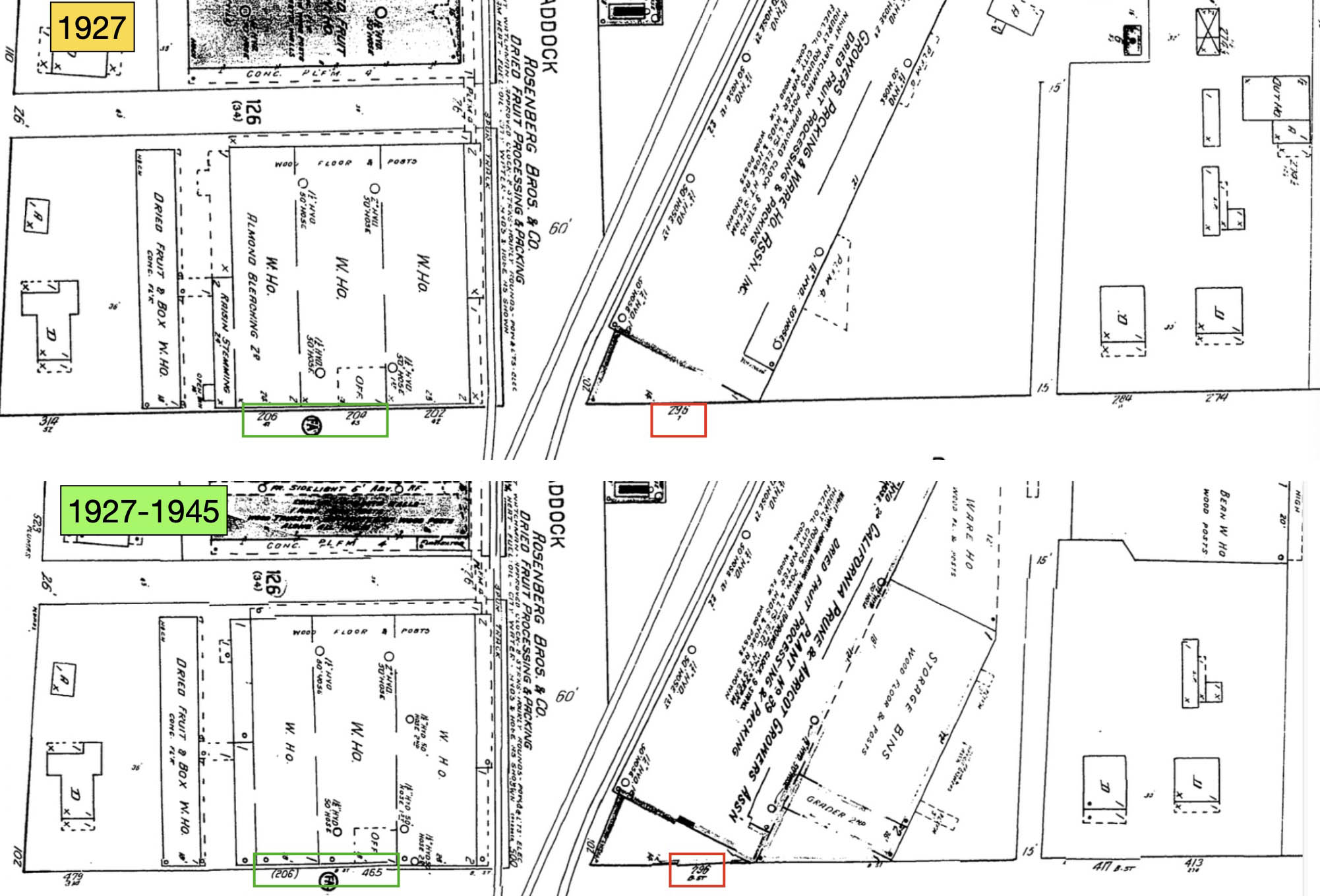
Based on the two Sanborn Maps shown here, the numbering along B St. between Plumas St. and Emerson Ave. was in the 200s in 1927, but is in the 400s in the updated map to 1945. That is, all except the building for Sunsweet, remaining at no. 296.
L307-60-Sanborn Maps, Courtesy Sutter County Museum, (Image 13 of 34)
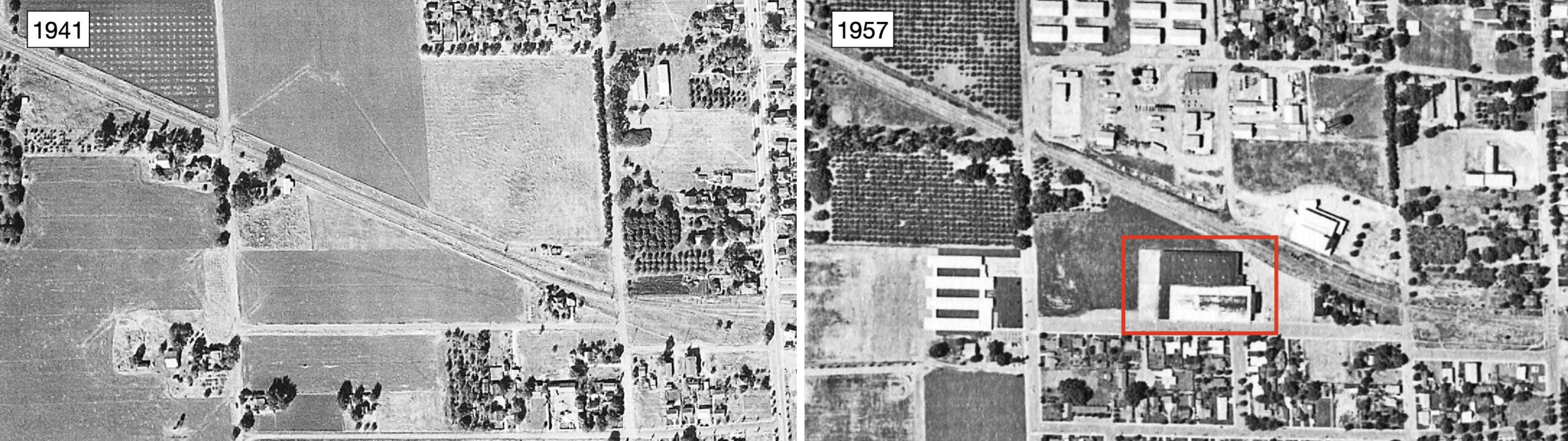
Although the Western Pacific Circular No. 167-E ca. 1957 lists Sunsweet, directories from that period provide the business at no. 909 Spiva Ave. The aerials from 1941 and 1957 show the addition of a large building at that address by 1957. The 1962 image in L307-55 of no. 296 B St. shows some type of product in the loading dock. The unanswered question is whether Sunsweet was still using the facility on B St., or if some other business took it over. According to the Vasonabranch.com website, Sunsweet was in Yuba City until 1964.
L307-65-Courtesy of UC Santa Barbara Library Geospatial Collection, c-7490_455, l, cas-1957, r, (Image 14 of 34)
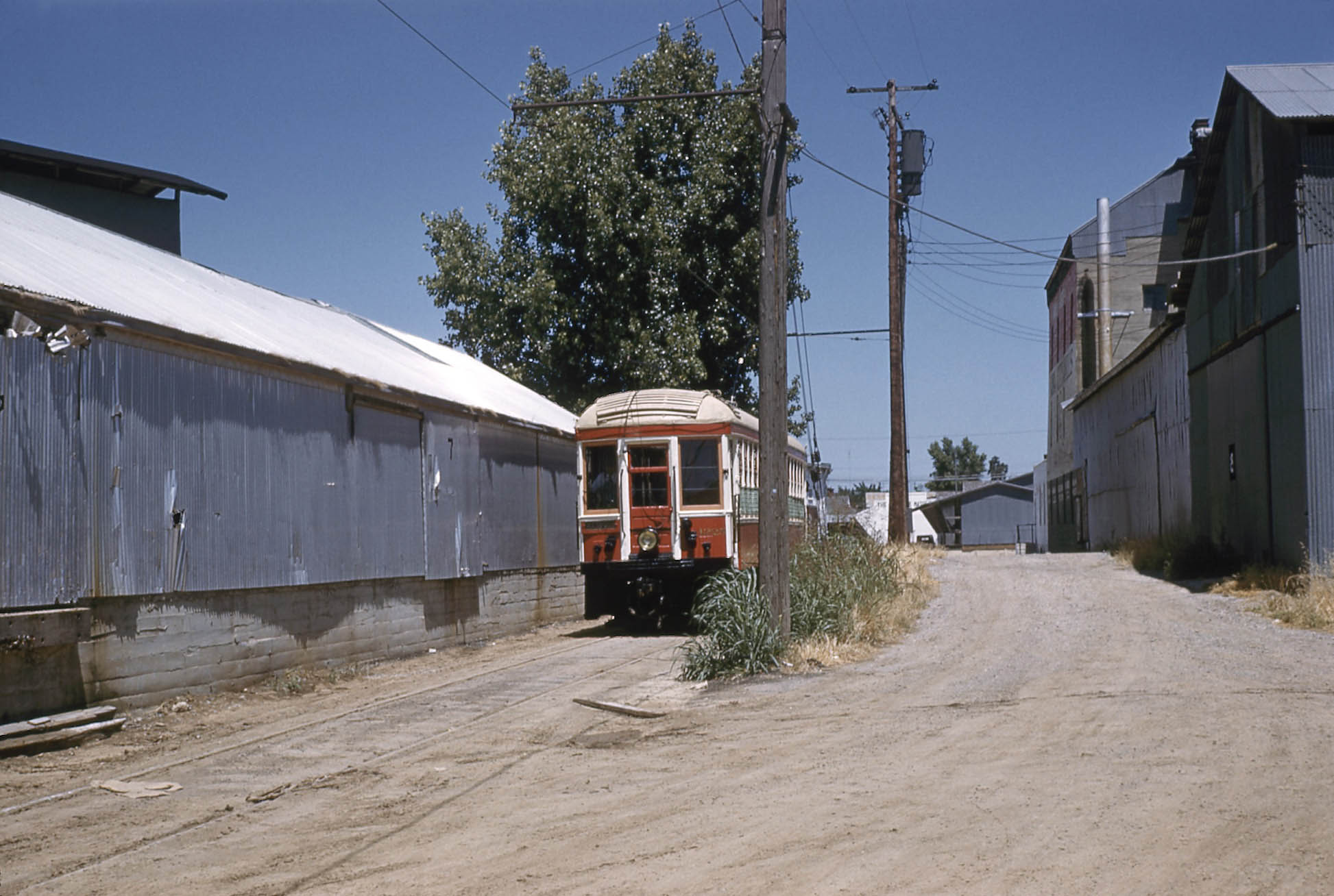
This northwest view taken by Ernest Haase during the excursion with British Columbia Electric Railway, BCER, 1225 on June 14, 1958 shows the streetcar in the SN spur identified in the 1938 diagram in L307-15 as that for Sunsweet. The presence of the multicolored, brick Yuba City Mills building along the center right, and the Diamond Match Co. sign in the distance verify the location of this image.
L307-70-Ernest Haase Photo, Moreau Collection, Courtesy BAERA, Western Railway Museum Archives, (Image 15 of 34)
This east-facing aerial from Dec. 24, 1955 showing the aftermath of the flood is inserted here with the Sunsweet spur, green line, with freight cars, added to the two SP spurs identified in the last update. The Yuba City Mills building is marked by the turquoise arrow to match against the building seen in the previous image.
L307-75-Copyright California Department of Transportation, 4724-14, (Image 16 of 34)
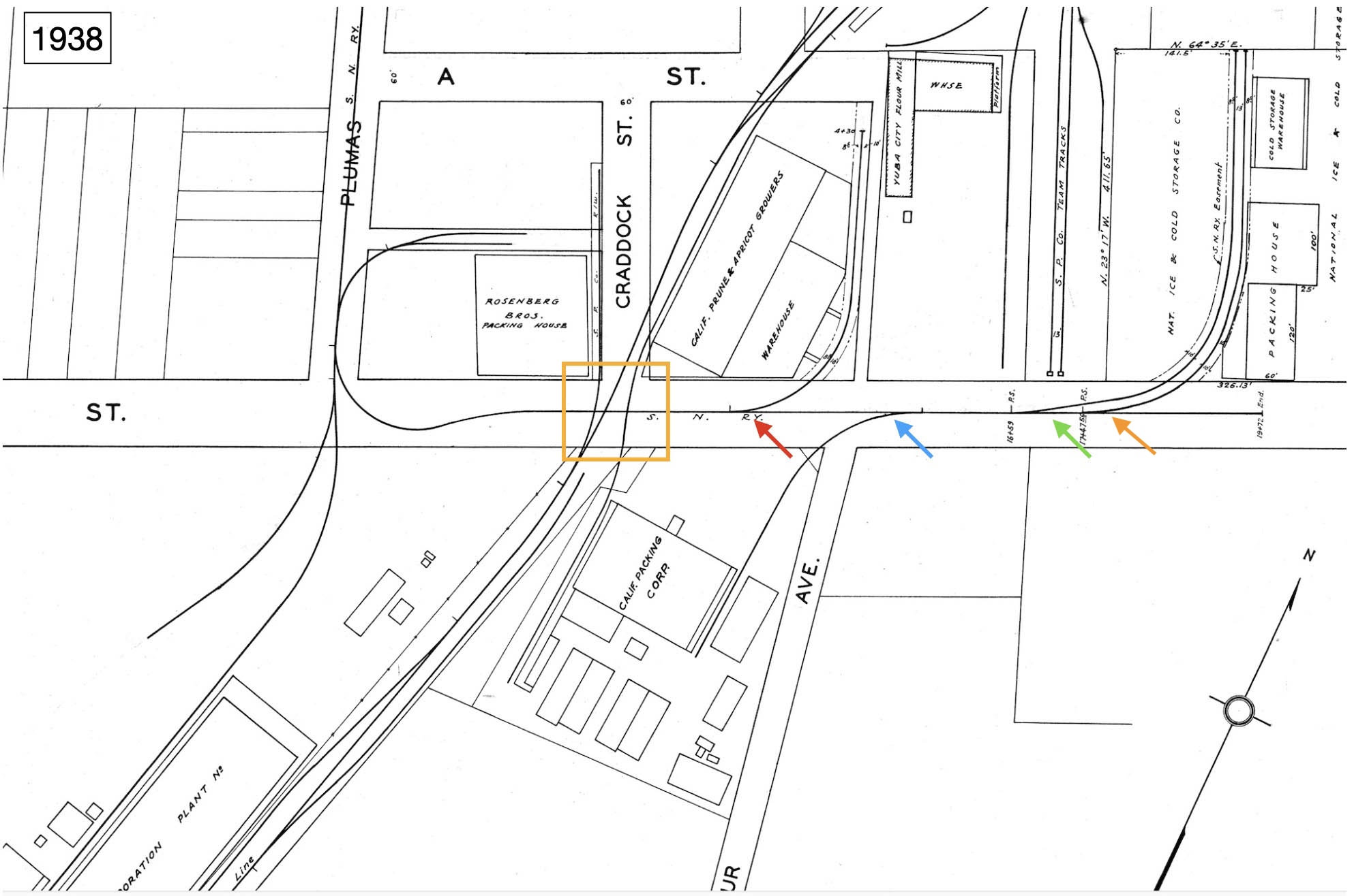
Up to this point, the ground shots of B St. have covered the street itself only to the SP crossing. Reviewing the diagram from 1938 shown here, there is the potential in 1957 for four more spurs, that should have their switches or take-off points from the main track down the middle of the street. Heading east from the last image, the question is whether the placement of the switch to the Sunsweet spur can be documented as well as ones for the remaining three spurs.
L307-80-Courtesy BAERA, Western Railway Museum Archives, 28, (Image 17 of 34)
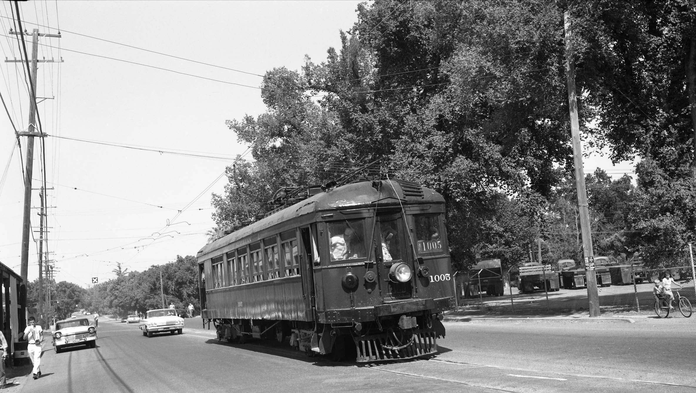
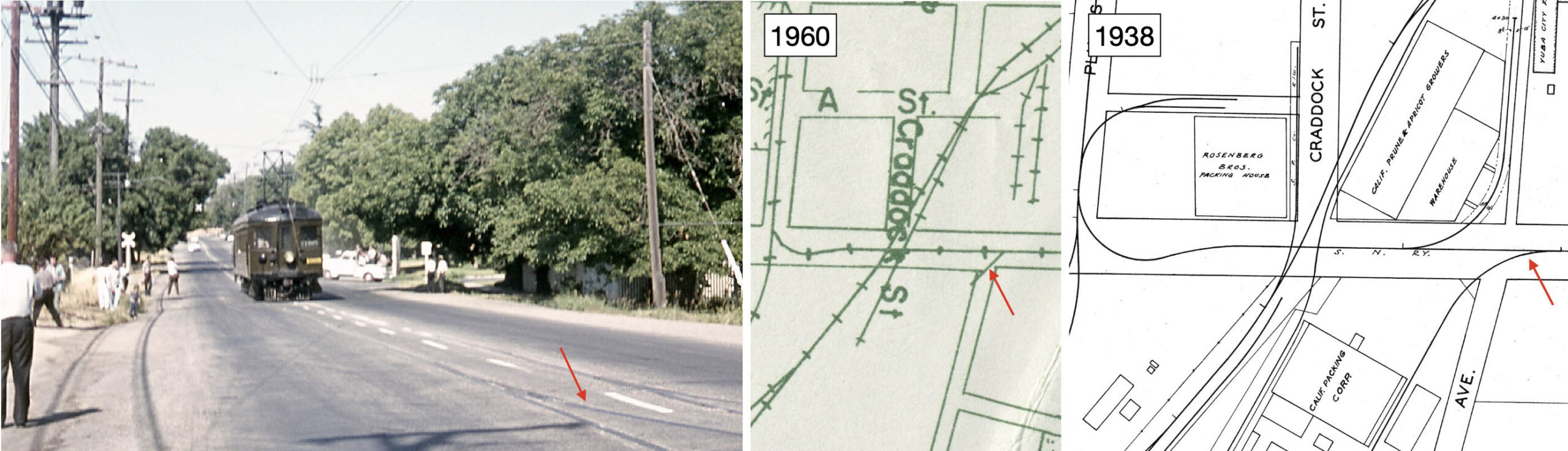
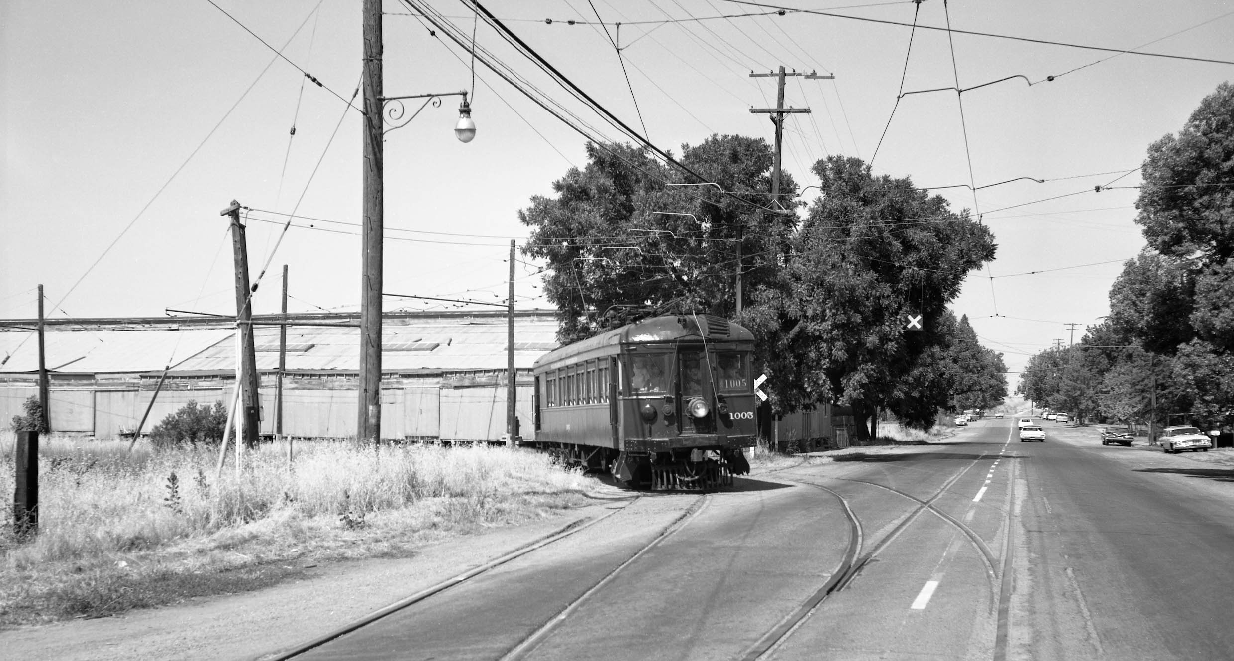
SN 1005 glides down B St. by the Sunsweet building on the left and Associated Transportation Co. on the right in this northeast image from the BAERA-sponsored June 17, 1962 excursion. The switch for the spur to Sunsweet can be seen right below the “X” marking the crossing for oncoming vehicles.
L307-85-Addison Laflin Photo, Courtesy BAERA, Western Railway Museum Archives, 173952sn, (Image 18 of 34)
The next spur to the east is pictured in the left panel in the foreground in this northeast view of SN 1005 on its last North End excursion, Apr. 14, 1964. The 1938 diagram shows this leading to a long spur into CalPak, right, the 1960 map shows a very short track just reaching across B St., center. Ref: Left, Moreau Collection, Courtesy BAERA, Western Railway Museum Archives; Center, Courtesy Earth Sciences and Map Library, University of California, Berkeley, G4364 Y8 1960 S8 Case D; Right, Courtesy BAERA, Western Railway Museum Archives, 28
L307-90-Multiple Attributions, (Image 19 of 34)
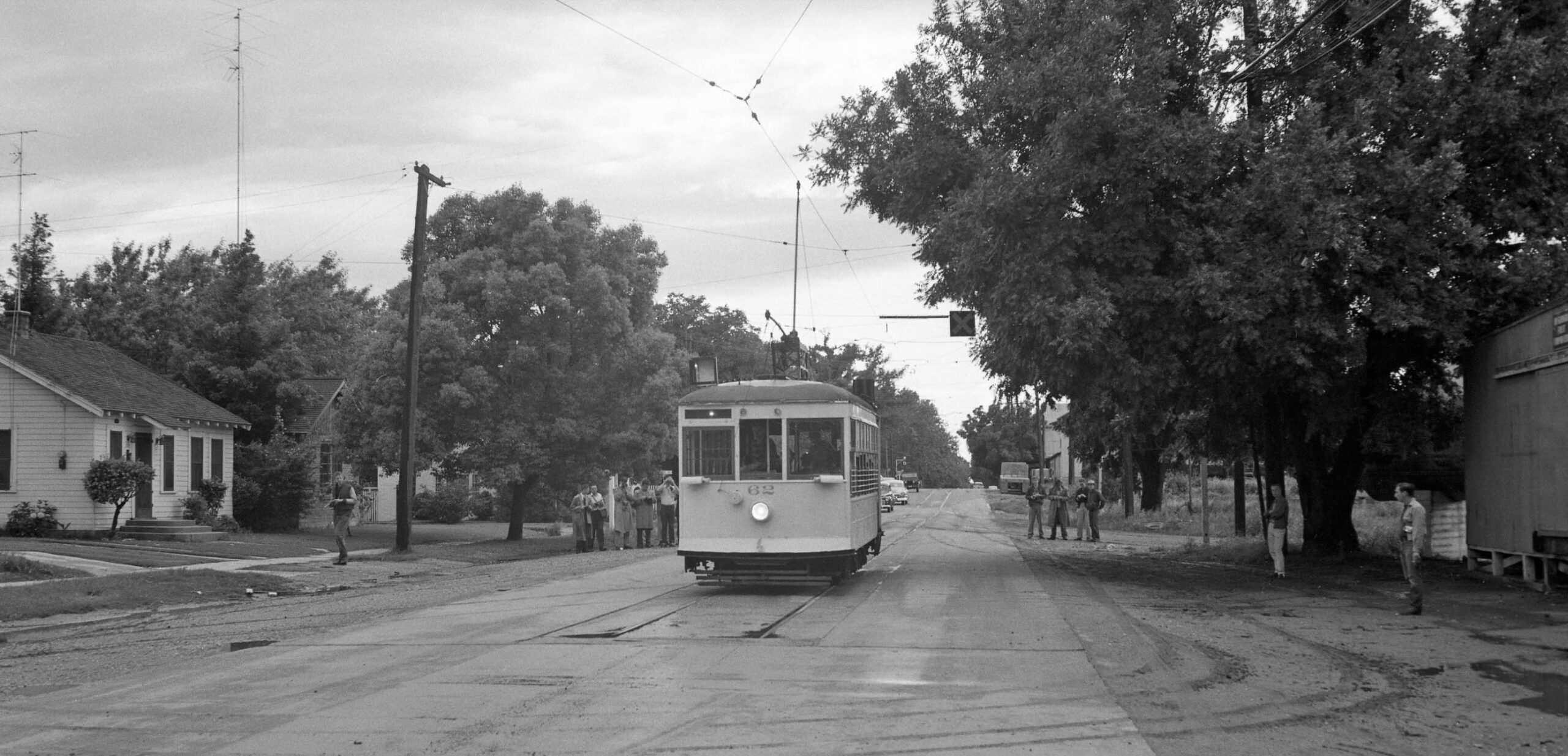
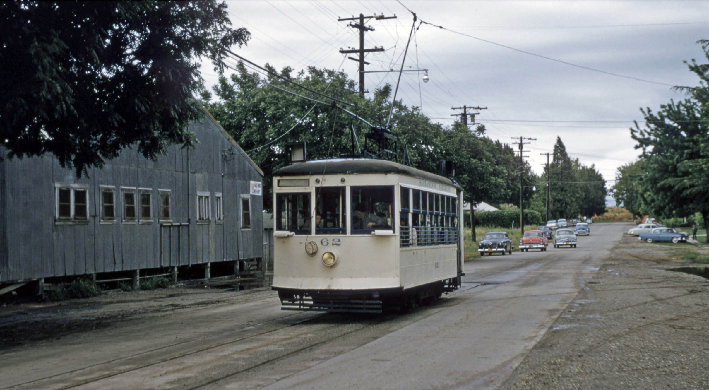
The switch for the spur identified in the last image angled south toward the southwest corner of Wilbur Ave. as seen in this southeast view of Birney 62 on the spur during the excursion on May 18, 1957.
L307-95-Moreau Collection, Courtesy BAERA, Western Railway Museum Archives, (Image 20 of 34)
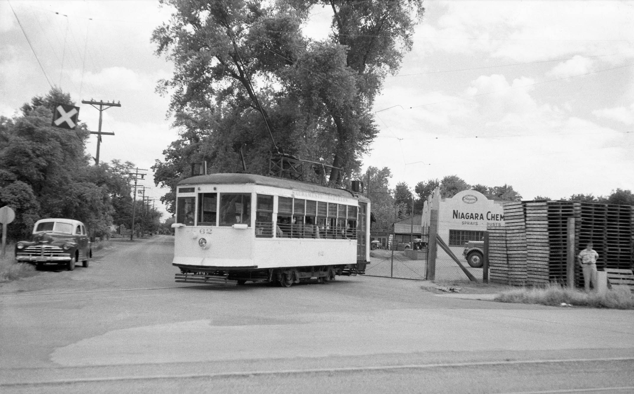
This southeast view of Birney 62 on the same day, May 18, 1957, shows the streetcar sitting outside a gate behind which are wooden pallets and Niagara Chemical written on the building in the back of that lot. This spur should be supplying either Associated Transportation Co. or Calpak, but that information was not found. Niagara Chemical is not listed on the Western Pacific Circular No. 167-E ca. 1957. More research needed here.
L307-100-McDonald Collection, Courtesy BAERA, Western Railway Museum Archives, 217826sn, (Image 21 of 34)
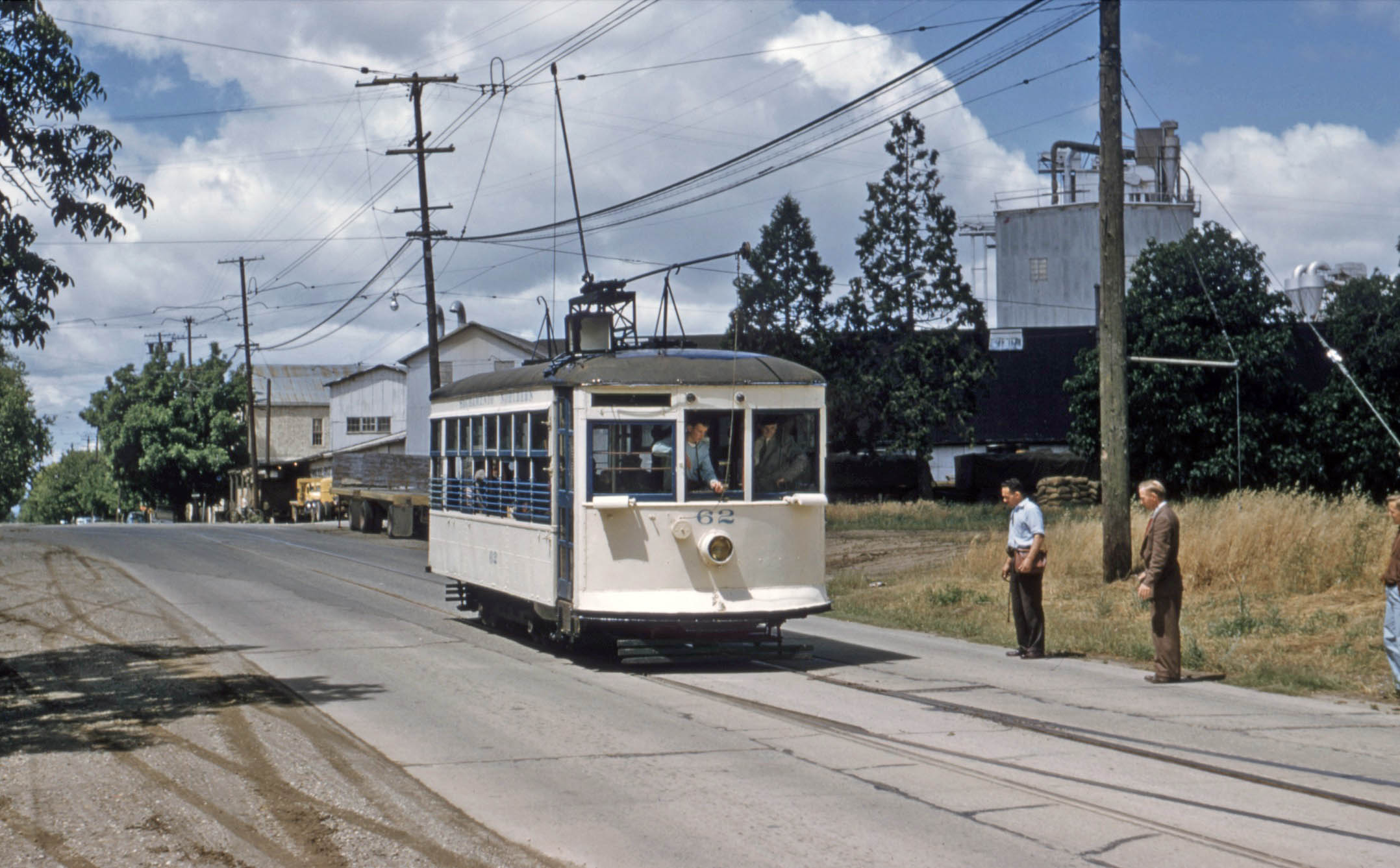
Birney 62 has proceeded east of the spur to Wilbur Ave. and pauses while the switch is set to access DiGiorgio and adjacent National Ice on May 19, 1957. The switch to Wilbur Ave. and the overhead wire that supplied it can be appreciated in the background.
L307-105-Richard Kampa Photo, Courtesy BAERA, Western Railway Museum Archives,163099sn, (Image 22 of 34)
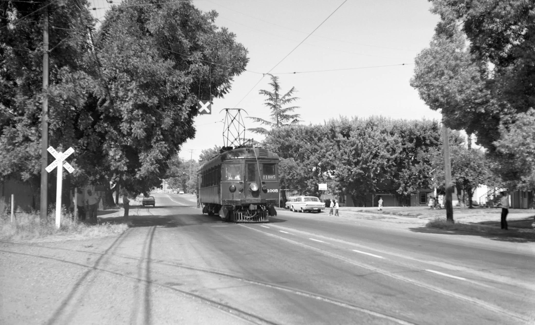
Further east on B St., SN 1005 sits close to the end of the line by the second switch to a second spur to access DiGiorgio, no. 359 B St., and adjacent National Ice, 340 Bridge St., on the June 17, 1962 BAERA-sponsored excursion. Next to follow the spurs leading into these facilities.
L307-110-McDonald Collection Courtesy BAERA, Western Railway Museum Archives, 217849sn, (Image 23 of 34)
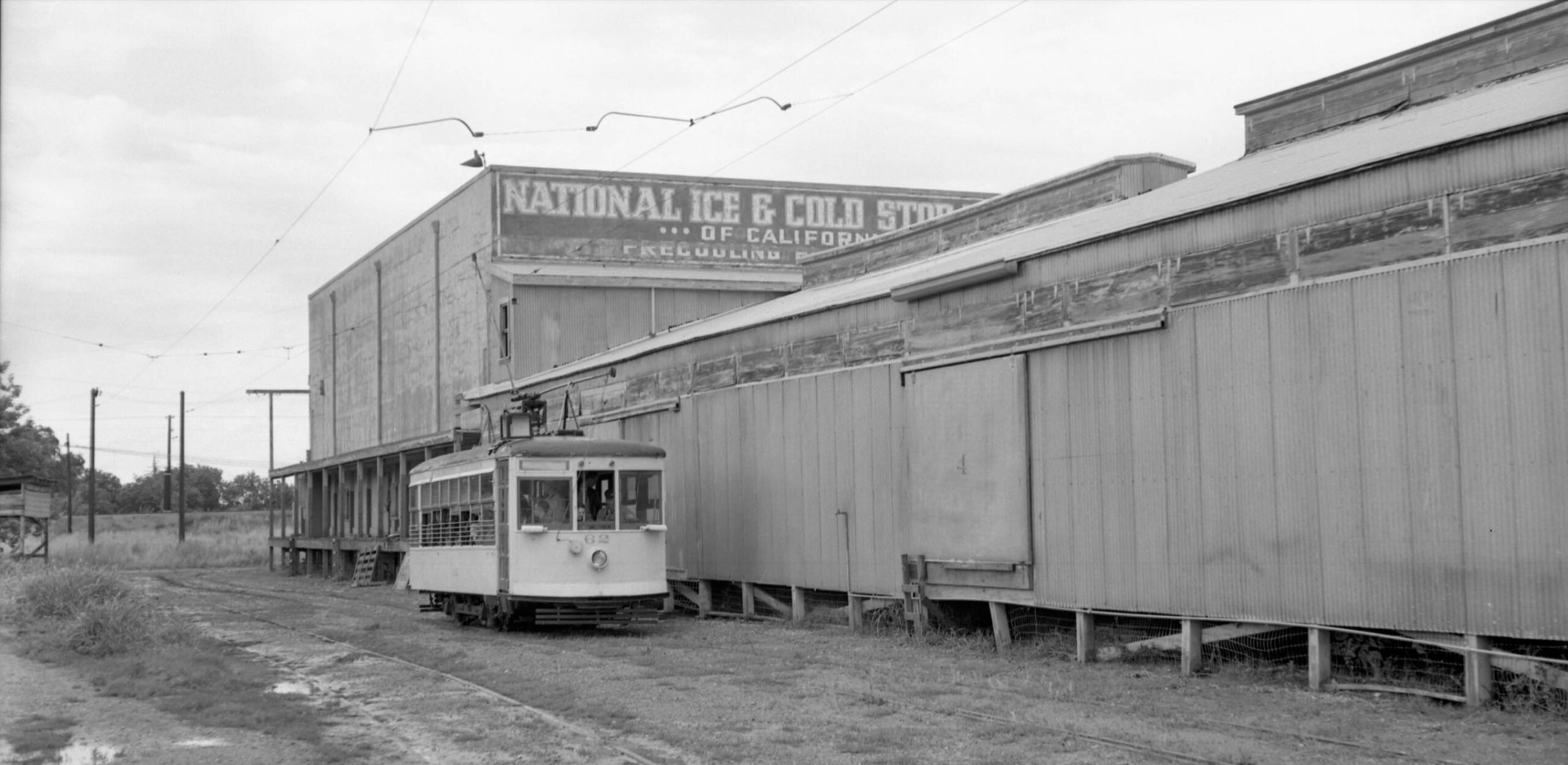
The two spur tracks continued first along the single story DiGiorgio warehouse, and ended by the taller National Ice structure. North view with Birney 62, May 18, 1957.
L307-115-Walt Vielbaum Photo, Courtesy BAERA, Western Railway Museum Archives, 133527sn, (Image 24 of 34)
The two north images of Birney 62 from May 18, 1957, right, and May 19, 1957, left, respectively, reveal the colorful National Ice Co. public entrance at 340 Bridge St., right, and the empty lot to the west, and the SN mainline on the berm along Bridge St. passing the Yuba City Cemetery in the background, left.
L307-120-Richard Kampa Photo, r, McDonald Coll. l, Courtesy BAERA, Western Railway Museum Archives, 163110sn, l, 217824sn, r, (Image 25 of 34)
Some additional color, BCER 1225, Birney 62 and the iconic National Ice sign, north view, June 15, 1958.
L307-125- Ernest Haase Photo, Photo Moreau Coll. Courtesy BAERA, Western Railway Museum Archives, (Image 26 of 34)
The structures housing DiGiorgio and National Ice did not survive the 1960s based on these aerial views, boxed in yellow. Both companies continued in California, but the dates of their departure from Yuba City are still undetermined.
L307-130-Courtesy of UC Santa Barbara Library Geospatial Collection, cas-1957, l, cas-2579_1-12, r, (Image 27 of 34)
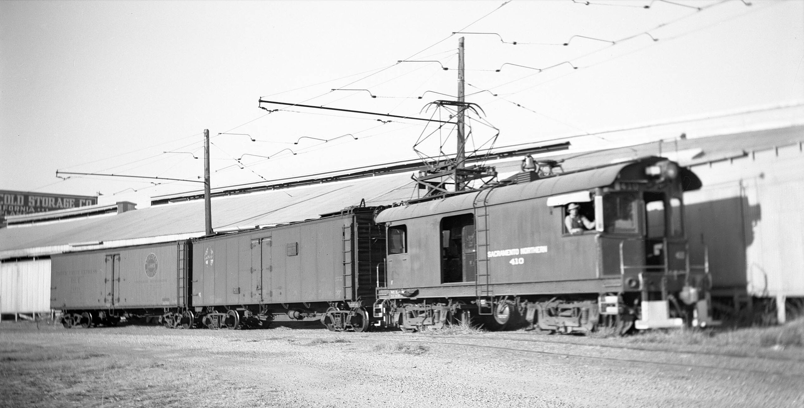
To give at least one piece of evidence that the industrial spurs on B St. were not created just to satisfy the photographic pursuits of railfans on streetcar excursions, a bona fide freight with SN 410 in the lead at DiGiorgio-National Ice in 1947, north view.
L307-132-Vernon Sappers Collection, Courtesy BAERA, Western Railway Museum Archives, 176763sn, (Image 28 of 34)
SN 1005 departs the spur for the mainline on June 17, 1962. The northeast view also includes the end of the line, the next and final stop.
L307-135-McDonald Collection, Courtesy BAERA, Western Railway Museum Archives, 217852sn, (Image 29 of 34)
End of the line, captured here in a southwest view from May 18, 1957. Note the writing on right edge, middle, “DiGiorgio Fruit …”
L307-140-McDonald Collection, Courtesy BAERA, Western Railway Museum Archives, 217812sn, (Image 30 of 34)
However, looking northeast from the terminal location at Birney 62, May 18, 1957, a sign for “Earl Fruit Company” can be seen. Earl Fruit Co. was the dominant fruit packing business in California when a more diversified DiGiorgio purchased it in 1911. Lots of material on the internet on DiGiorgio’s history.
L307-145-Richard Kampa Photo, Courtesy BAERA, Western Railway Museum Archives, 163100sn, (Image 31 of 34)
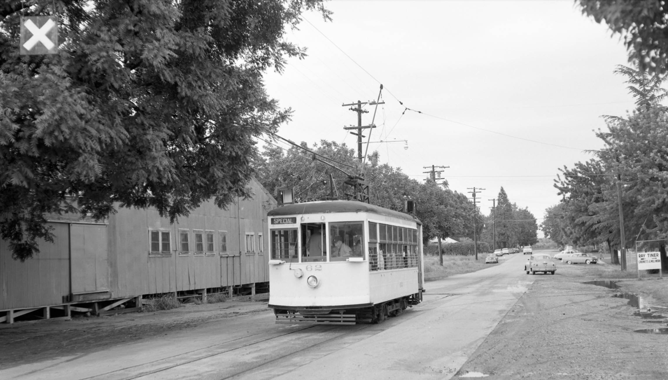
A similar northeast from the terminal location with Birney 62 also on May 18, 1957 documents that although the end of the line meant the end of big industry, smaller concerns such as Ray Tiner Cabinets continued along this primarily residential stretch of B St. heading east to the Feather River.
L307-150-Walt Vielbaum Photo Courtesy BAERA, Western Railway Museum Archives, 133538sn, (Image 32 of 34)
To end this section, two aerial views from Feb. 8, 1972, starting with this northwest view showing the absence of the building housing Sunsweet, and the addition of an industrial building on the empty space adjacent to the former site of DiGiorgio-National Ice.
L307-155-Copyright California Department of Transportation, 17568-2, (Image 33 of 34)
A slightly turned view of the same location looking to the northwest on Feb. 8, 1972. Next time, the ice loader and other features of the central freight yard.
L307-160-Copyright California Department of Transportation, 17568-3, (Image 34 of 34)