St. Mary’s Station to the Bridge

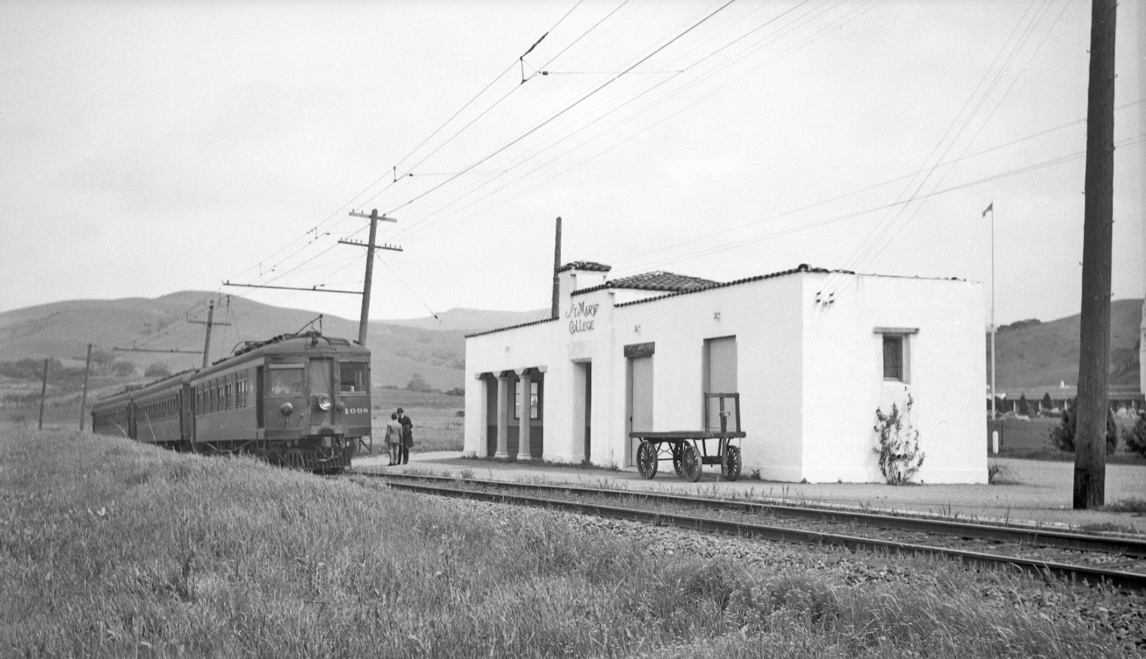
The shelter at St. Mary’s College was erected by the college to match the Mission-style buildings of the campus. The date of its construction remains elusive, although the college did not begin operations in Moraga until 1928. Northeast view with SN 1008, 1940.
L49-05-Charles Savage Photo, Courtesy Tom Gray, (Image 1 of 21)

An east view of SN 652 and the last freight, Feb. 28, 1957, shows the distance from the shelter to the revised main entrance that is still used today.
L49-10-EK Muller Photo, Courtesy BAERA, Western Railway Museum Archives, 45012sn, (Image 2 of 21)

Almost ten years earlier in 1948, SN 661 makes its way with a freight over the same grade crossing in this east view.
L49-15-Roger Heller Photo, from the collection of the Moraga Historical Society, Moraga, CA, NN-2, (Image 3 of 21)

This north view of the station area during an excursion with MW 302, May 2, 1954, reveals only the grade crossing sign from this perspective. Eddie Hansen uses the time to take a break from his excursion duties.
L49-20-Dudley Thickens Photo, Courtesy BAERA, Western Railway Museum Archives, 63591sn, (Image 4 of 21)

During the passenger era, the main entrance to the college was further north and utilized a bridge to cross the busy SN right-of-way. The track bed had already begun its decent in a cut that still exits today. North view of SN 1005, June 6, 1940.
L49-25-Ted Wurm Photo, Courtesy BAERA, Western Railway Museum Archives, 240164sn, (Image 5 of 21)

L49-26-Ted Wurm Photo, Courtesy BAERA, Western Railway Museum Archives, 240164sn, (Image 21 of 21)

This north view aerial from February 9, 1937 shows the relationship of the entrance and bridge to the SN shelter. Ref. Pacific Resources Inc, #19, CC-C-11-1.
L49-30-HJW Geospatial Inc, Oakland, CA, and the collection of the Moraga Historical Society, (Image 7 of 21)

The bridge over the right-of-way provided another vantage point for SN photographers. South view, circa 1940.
L49-35-Paul Smith Photo, Courtesy BAERA, Western Railway Museum Archives, 52967sn, (Image 8 of 21)

With passenger rail service ending in July of 1941, daily train traffic was markedly reduced. St. Mary’s College was chosen as a site for pre-flight training for navel cadets in 1942, increasing the student population seven-fold. At some point during this period, the college decided to move the entrance of the college to the position it now occupies. South view with SN 661 and the return of passenger cars to Chico, Jun. 30, 1941.
L49-40-Courtesy BAERA, Western Railway Museum Archives, 50151sn , (Image 9 of 21)

Correspondence preserved at the Western Railway Museum Archives between the railroad and the college in 1945 indicated that the bridge had been out of service for sometime, was in need of repair, and that it was probably best to remove it. The upper third at the left edge of this northeast view from 1947 shows the absence of the bridge and evidence for excavation.
L49-45-HJW Geospatial Inc, Oakland, CA, and the collections of the Saint Marys College of California, (Image 10 of 21)

The formation of BAERA and the initiation of rail excursions after WWII provided rail fans with many photo opportunities at the now boarded-up shelter. North view with MW 302, Sept. 12, 1948.
L49-50-Tom Gray Photo, Courtesy Tom Gray, (Image 11 of 21)

Another example of the same north view with MW 302, Sept. 12, 1948.
L49-55-Arthur Lloyd Photo, Courtesy Arthur Lloyd, (Image 12 of 21)

And yet one more example, but this time in living technicolor. North view with MW 302, Sept. 12, 1948
L49-60-Louis L Stein Photo, Courtesy BAERA, Western Railway Museum Archives, 63131sn, (Image 13 of 21)

Excursion photos remained popular into the 1950s, here a north view with MW 302 from May 2, 1954. With the passing of time, the small shelter was maintained as it stood just to the south of the new main entrance road.
L49-65-LL Bonney Photo, Courtesy John Harder, (Image 14 of 21)

It has been stated that the shelter served as a bus station into the early 1990s, but no pictorial proof has surfaced. Here, a north view circa 1950 shows a SN 661 freight forcing a bus to wait at the grade crossing. But, is the bus bound for the shelter? Who knows ....
L49-70-Tom Gray Photo, Courtesy Tom Gray, (Image 15 of 21)

A comparison of a west view from 1960, left, with the station clearly visible, yellow arrow, to a south view from 1962, right, where only a footprint of the building survives, yellow arrow, suggests the station shelter was removed in the interval. Additional comparisons between 1958 and 1968 on historicaerials.com produced a similar result for that interval. Ref: RL Copeland photo, right, Herrington-Olsen photo, A-2895, right.
L49-75-from Saint Marys College of California Archives, and the Moraga Historical Society, (Image 16 of 21)

The 1915 Oakland, Antioch and Eastern flag stop to the area was called Country Club, related to a failed Moraga Co. effort, and the SFSRR 1923 schedule called it Cashion. Images of either have not been found. The image seen here was a spur built in 1927, presumably a temporary one to help build the college.
L49-80-From the collection of the Moraga Historical Society, Moraga, CA, (Image 17 of 21)

L49-80 lines up well with L49-10, insert, to provide the location of this track. Special thanks to Susan Skilton for providing the spur image.
L49-85-From the collection of the Moraga Historical Society, and BAERA, (Image 18 of 21)

SN 660 leaves the cut as it approaches the station, northeast view, circa 1950.
L49-90-Robert P. Townley Photo, Courtesy Robert P. Townley, (Image 19 of 21)

SN 661 heads north of the cut, south view, circa 1950.
L49-95-Robert P. Townley Photo, Courtesy Robert P. Townley, (Image 20 of 21)