The Early Oakland, Alameda and Berkeley Days, 1912-1934
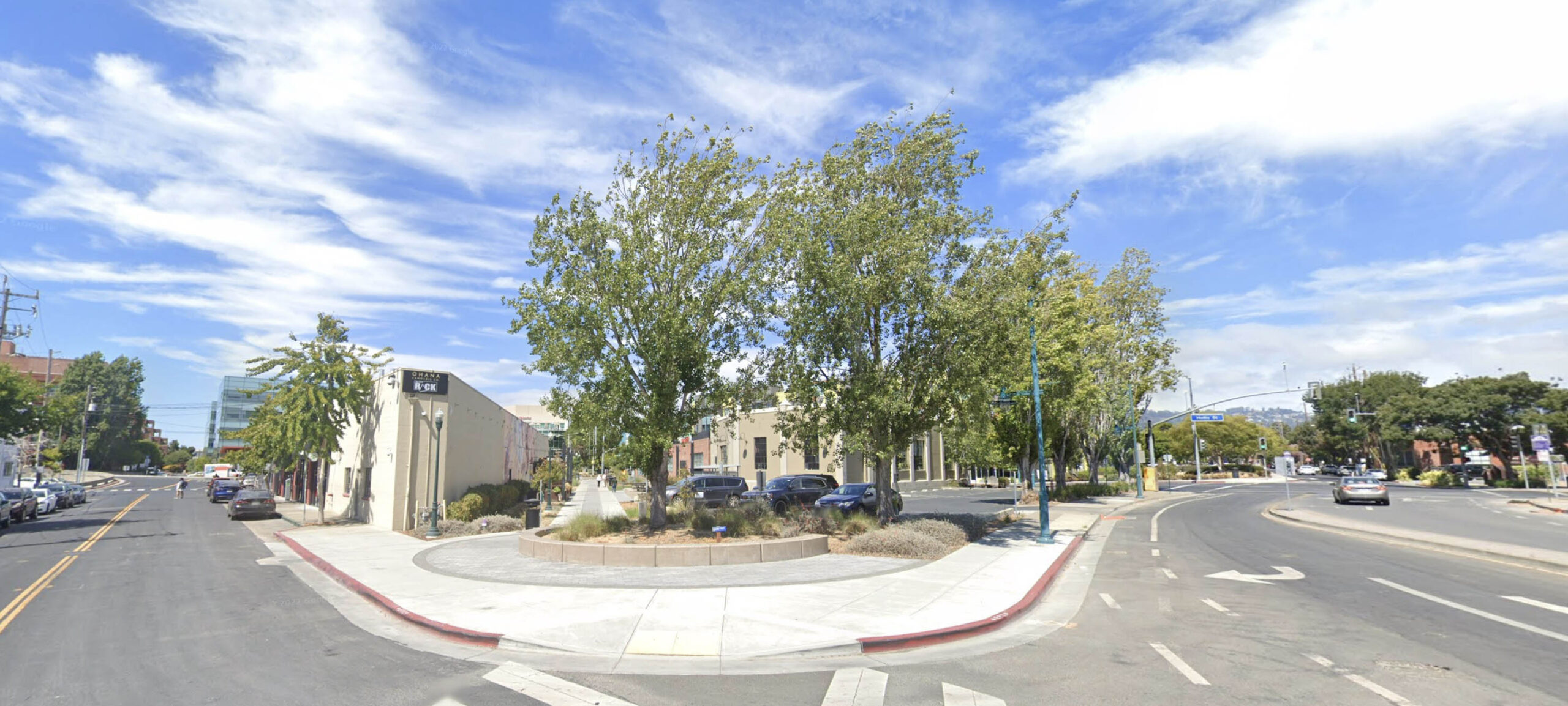
The Emeryville Greenway connects the commercial section at Hallick St. and Sherwin Ave. to South Berkeley via the Berkeley 9th St. Greenway. In this northeast view, the intersection of Peladeau St., left, and Stanford Ave., right, marks the beginning of a corridor heading northeast once occupied by the Southern Pacific, SP, Ninth St. “Red Trains.” This final section of abandoned right-of-way was incorporated into the trail in 2017. For this update, the section from Peladeau St. to Heinz Ave. will use the term “Greenway” to denote the continuous trail.
L326-05-Courtesy Google Maps, (Image 1 of 34)

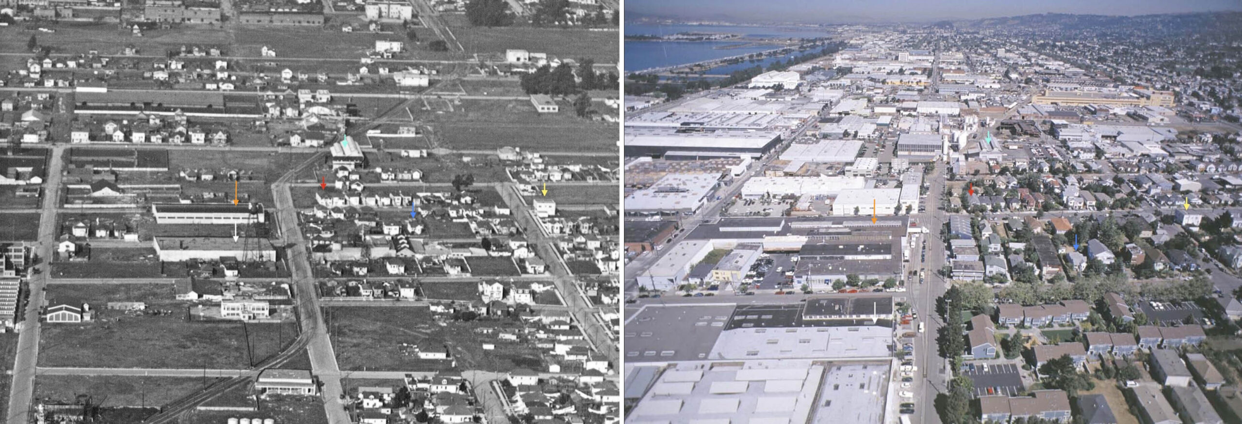
From Peladeau St., the trail reflects most of the private right-of-way and city streets used by the trains from 1912 until approximately 2002. A north view from ca. 1925 on the left shows the line when it served both passengers and freight, continuing down Ninth St. in Berkeley to Solano Ave. in Albany, versus a similar view from 2002 on the right as a freight-only line ending at Heinz Ave. and Ninth St. in Berkeley. The arrows mark a few corresponding structures to line up the two images that are not superimposable.
L326-10-George Russell Photo, California State Lands Commission, SLC_642_NoDate_12, l, City of Emeryville, prepared by the ROMA Design Group, r, (Image 2 of 34)
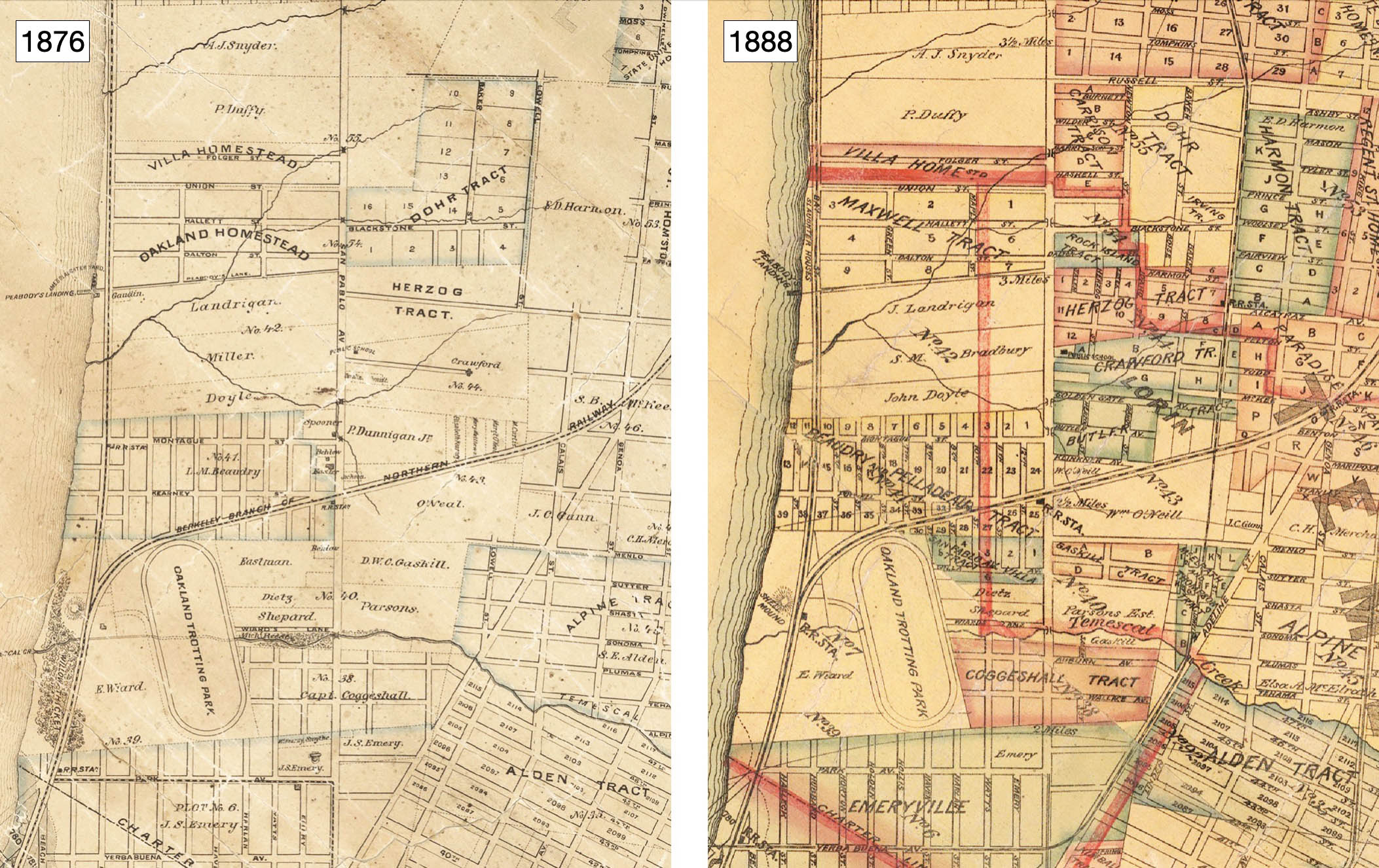
The map on the left from 1876 shows the area to be reviewed as unincorporated Alameda County. The Berkeley Branch of the Northern Railway, a subsidiary of the Central Pacific Railroad, began operation that year. The map of 1888, right, shows little growth west of San Pablo Ave., the borders between Berkeley, Oakland, and Emeryville added prematurely. Ref: Left, Map of Oakland, Alameda and Vicinity, M. G. King, Author-Publisher; Right, Map City of Oakland and Surroundings, J.C. Henkenius, Author, Woodward, Gamble, Publisher.
L326-15-Courtesy David Rumsey Map Collection, David Rumsey Map Center, Stanford Libraries, (Image 3 of 34)
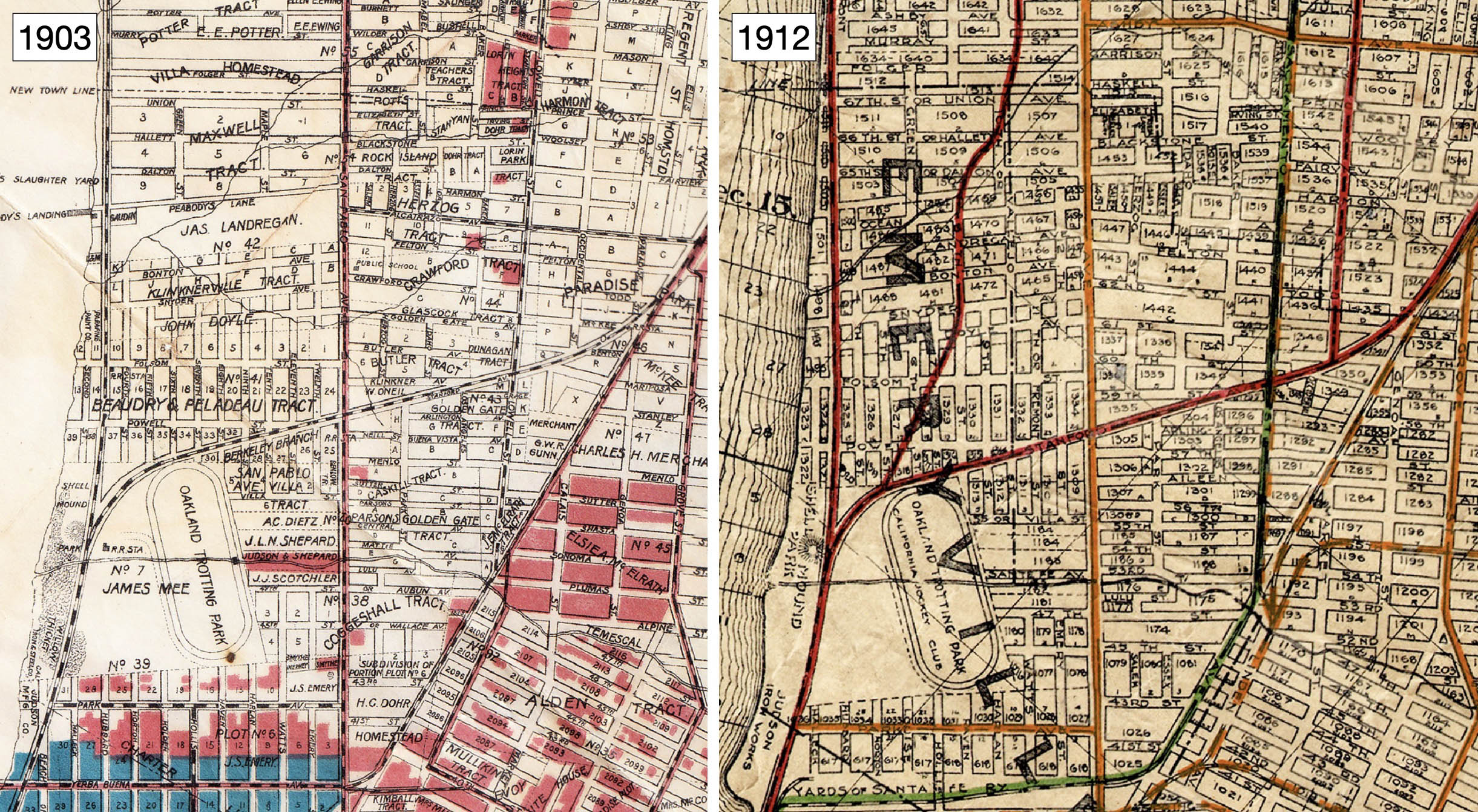
Leading up to 1903, left, the southwest border of Berkeley to the future north border of Emeryville was set in 1891, incorporation of Emeryville in 1896, and the annexation of the Golden Gate neighborhood to the City of Oakland in 1897 completed the land through which the future Greenway would traverse. On the right, the SP Ninth St. electric passenger-steam freight operation was initiated In Feb. 1912. The portion of right-of-way on Emeryville streets was called Ninth St. and not Doyle St., and Doyle Ave. was perpendicular to it.
L326-20-Realty Syndicate Map, l, Realty Bonds and Finance Co. Map, r, John Bosko Collection, Courtesy John Bosko, (Image 4 of 34)
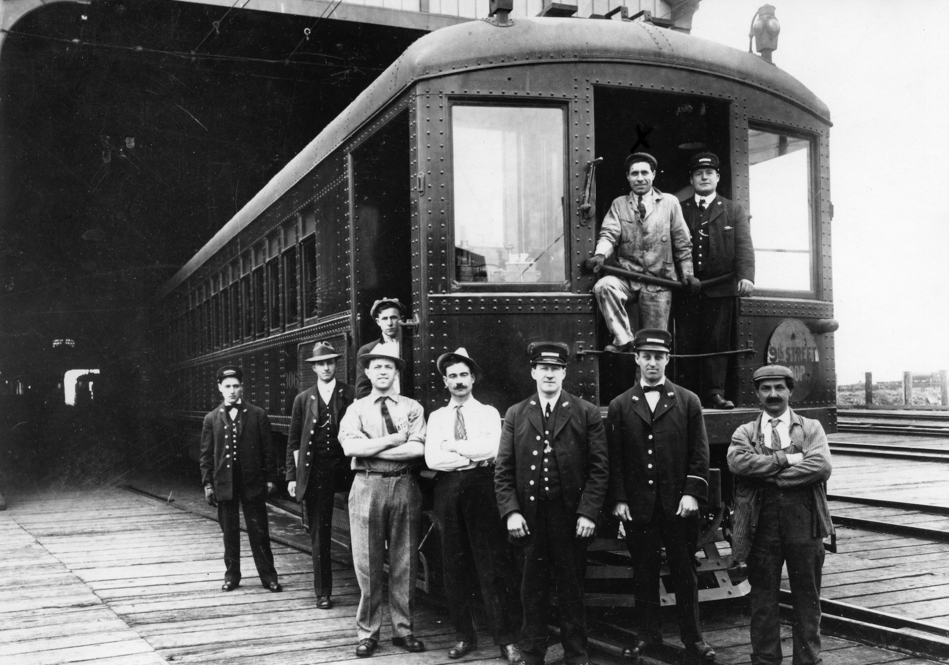
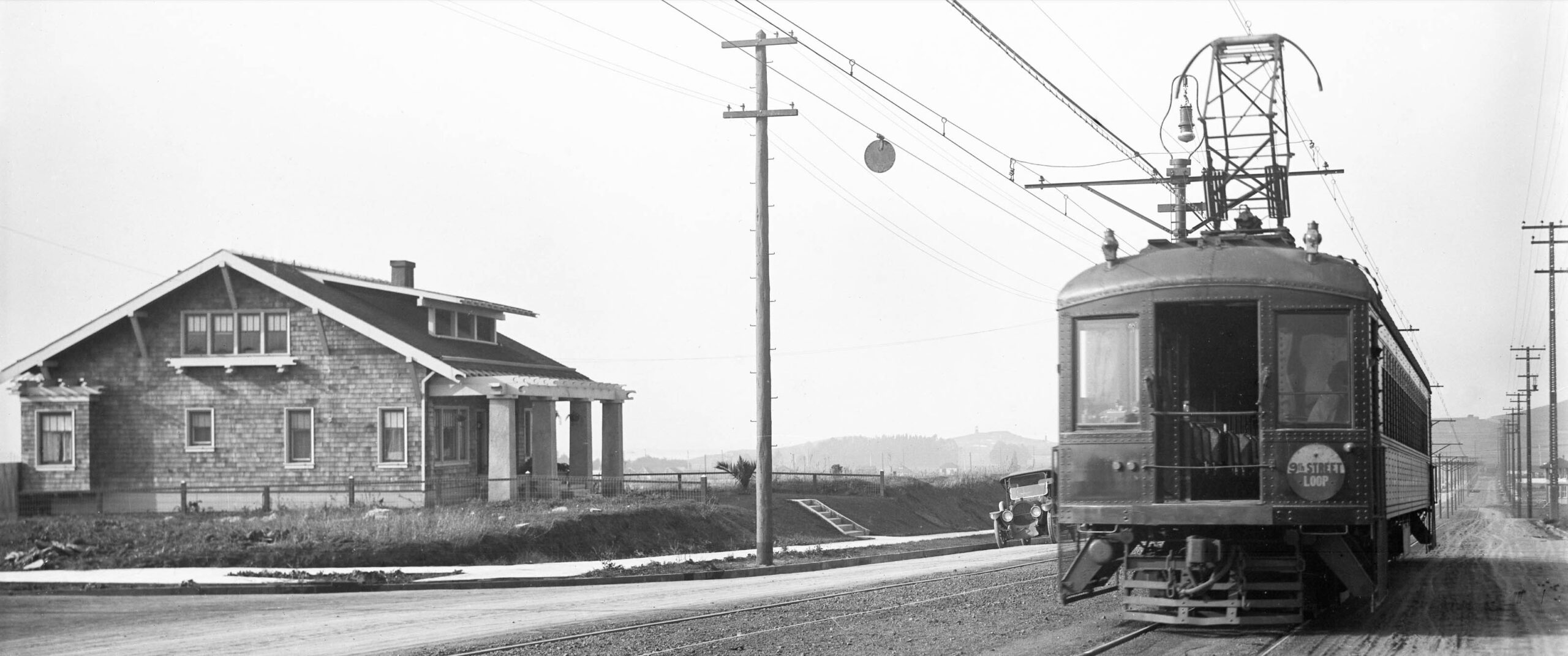
The Ninth St. line received passengers coming via ferry from San Francisco to the Oakland Pier, pictured here ca. 1912. The passengers cars were long, red in color, and had large rectangular windows that were later deemed to be a safety hazard on impact, and would be replaced by smaller, round portals. Unlike the Key System interurbans, the cars were more akin to those used on the long distance steam lines, as was the staffing to operate them. Two of many reasons why the SP’s electric venture in the East Bay lost money the minute it was started.
L326-22-SP Photo, Vernon Sappers Collection, Courtesy BAERA, Western Railway Museum Archives, 244270oa&b, (Image 5 of 34)
The next early image is of an early Ninth St. line train heading west on Solano Ave. The term “loop” on the train shield will become apparent soon. Unfortunately, ground views of passenger or freight trains in the section transformed to the Greenway were not found dated prior to 1938.
L326-25-Vernon Sappers Collection, Courtesy BAERA, Western Railway Museum Archives, 22388oa&b, (Image 6 of 34)
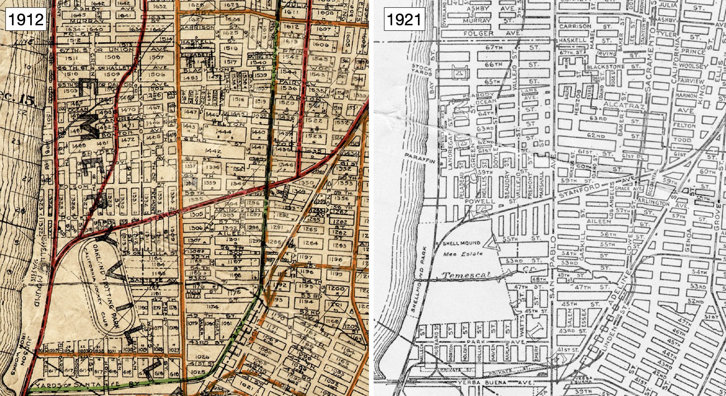
Compared with 1912, left, the street names by 1921 surrounding the train line and including Doyle St. as part of its right-of-way matches the grid in 2025. By 1924-1925, the SP’s Western Division or Oakland, Alameda and Berkeley, OA&B, electric lines had reached its peak in terms of routes, although more than a decade of losing money had in some cases saw slightly less passenger trains running per day. For more, see Robert S. Ford’s “Red Trains in the East Bay”, Interurbans Press, Glendale, CA, 1977.
L326-30-Realty Bonds and Finance Co. Map, John Bosko Collection, Courtesy John Bosko, l Central National Bank Map, Courtesy BAERA, Western Railway Museum Archives, 83537, r, (Image 7 of 34)
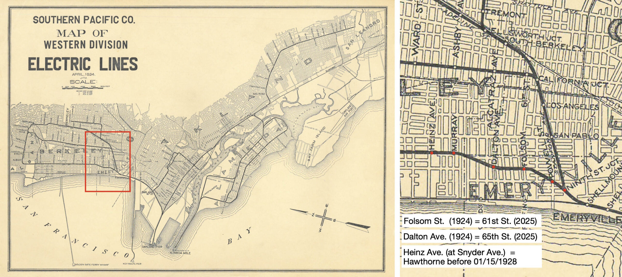
The 1924 map of SP electric lines, left, shows the use of loops to connect various parts of the system, the Ninth St. line forming a loop with the California St. line at Thousand Oaks. The detail, right, has the Ninth St. line passenger station stops, red dots, using the date appropriate, but since retired street names Dalton Ave. and Folsom St. for 61st. and 65th Sts., respectively. However, Heinz Co.. did not enter Berkeley until 1926. Ford notes the stop was called Hawthorne at then Snyder Ave. until early 1928. The map was composed after 1928.
L326-35-Courtesy BAERA, Western Railway Museum Archives, (Image 8 of 34)
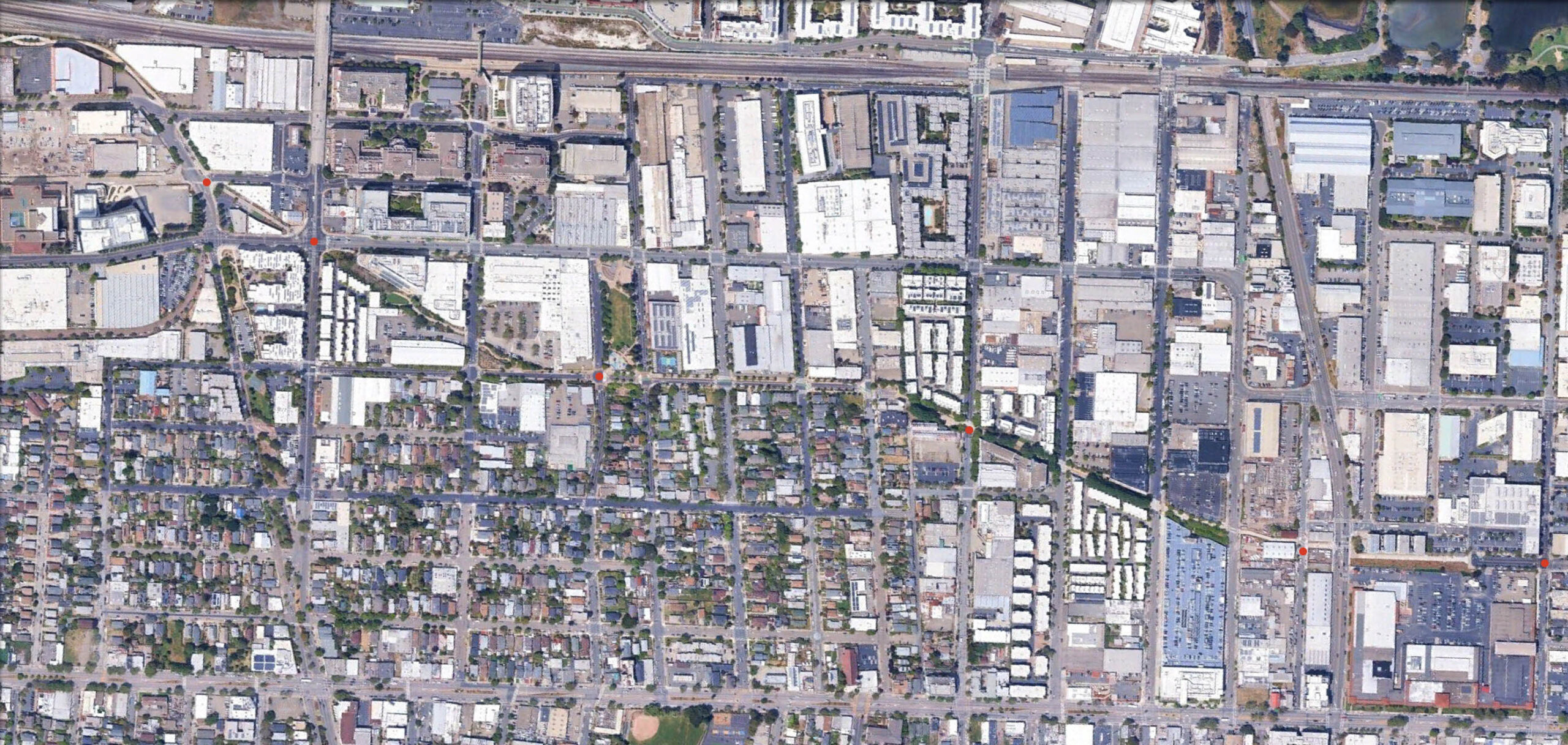
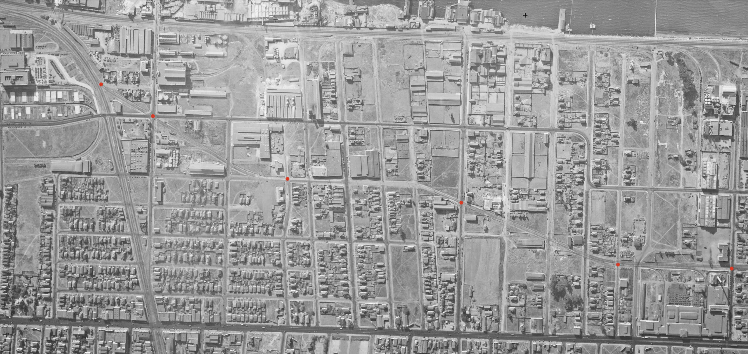
To become familiarized with where exactly the trains ran relative to 2025, this vertical aerial view of the Greenway from 2025 is presented oriented with north to the right edge. The Ninth St. station stops shown in the previous map have been placed on this map. Ground views of the active right-of-way prior to 1923 have not been found, but the SP documented the right-of-way sans trains in 1923 and 1934, the latter probably to account for the elimination of SP lines related to eventual sharing track on the Bay Bridge, although the Ninth St. line was untouched.
L326-40-Courtesy Google Earth, (Image 9 of 34)
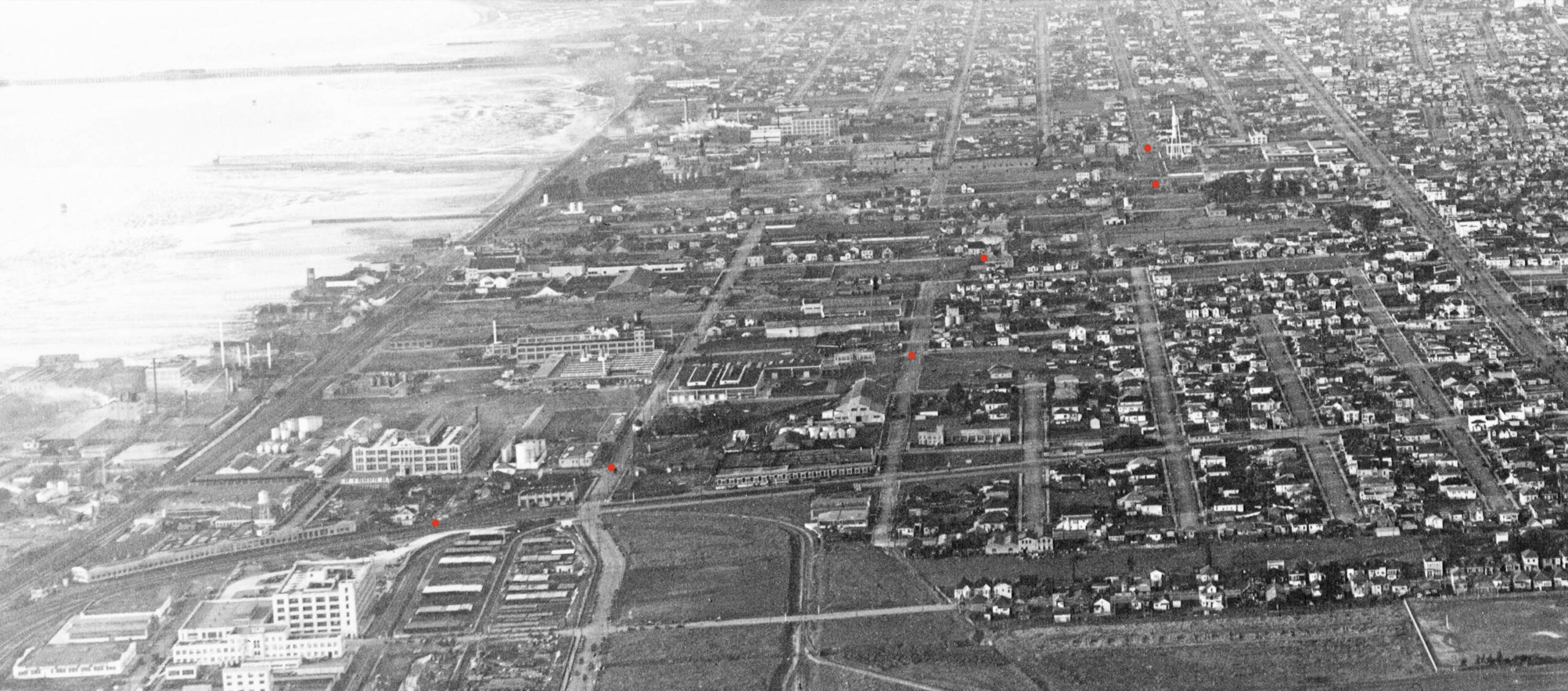
This vertical aerial view from 1931 presented may be superimposed on the previous aerial from 2025. It will serve to bridge the ground views taken between 1923 and 1934, and aerial views taken by George Russell ca. 1925-1927. It provides enough detail to view buildings, train tracks, including spurs and sidings used by freight service.
L326-45-c-1820_47, c-1820_48 Fusion, Courtesy of UCSB Library Geospatial Collection, (Image 10 of 34)
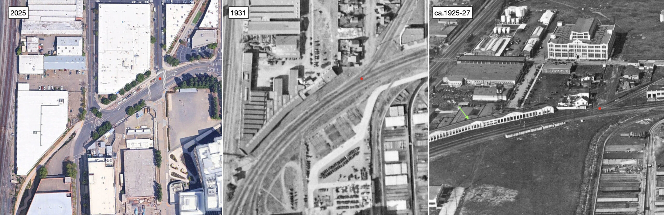
One of the George Russell oblique views of the area taken primarily between 1928 and the early 1930s is shown here. Based on the buildings seen in this north view, particularly the completed Heinz complex in Berkeley, dates it closer to 1930. The Ninth St. station stops shown in the previous map have been placed on this image as well.
L326-50-George Russell Photo, California State Lands Commission, SLC_644_NoDate_3, (Image 11 of 34)
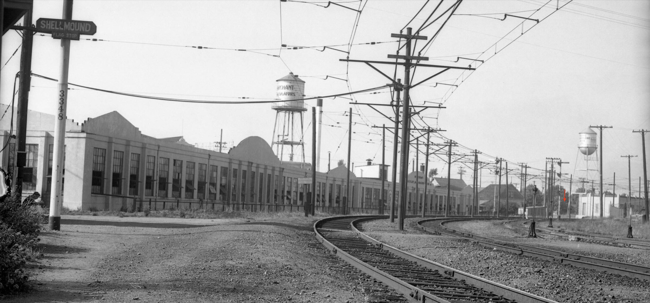
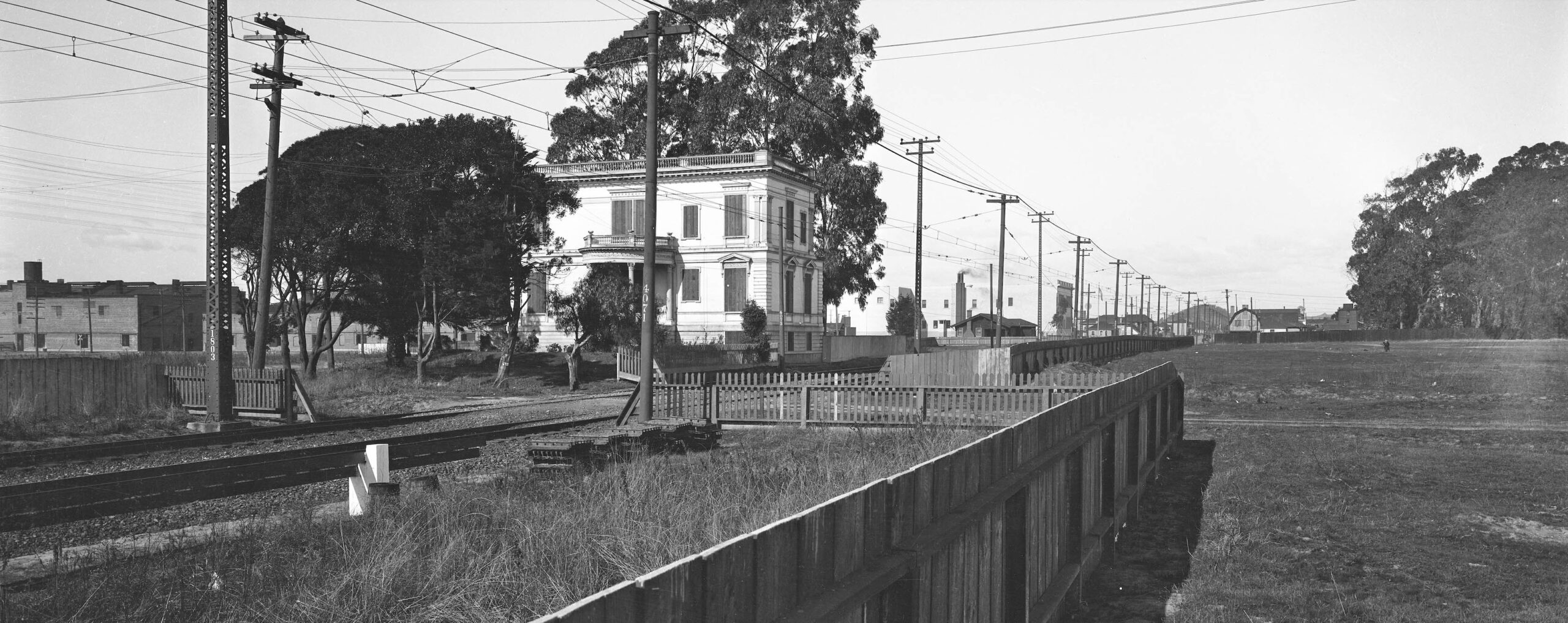
Onward to the railway-Greenway review, starting furthest south at Peladeau St. and Stanford Ave. This first set of aerials are now all oriented with north to the top of each image, with a red dot indicating the general location for the first passenger train stop, Ninth St. Junction, where Ninth St. trains separated from the three other electric trains lines heading into Berkeley between 1912 and 1933. After 1933, only the Shattuck line trains remained of those three. The green arrow points to the Marchant Calculating Machine Co. factory, right.
L326-55-Courtesy Google Earth, l, c-1820_47, Courtesy of UCSB Library Geospatial Collection, c, George Russell Photo, Courtesy California State Lands Commission, SLC-642_NoDate_12, r, (Image 12 of 34)
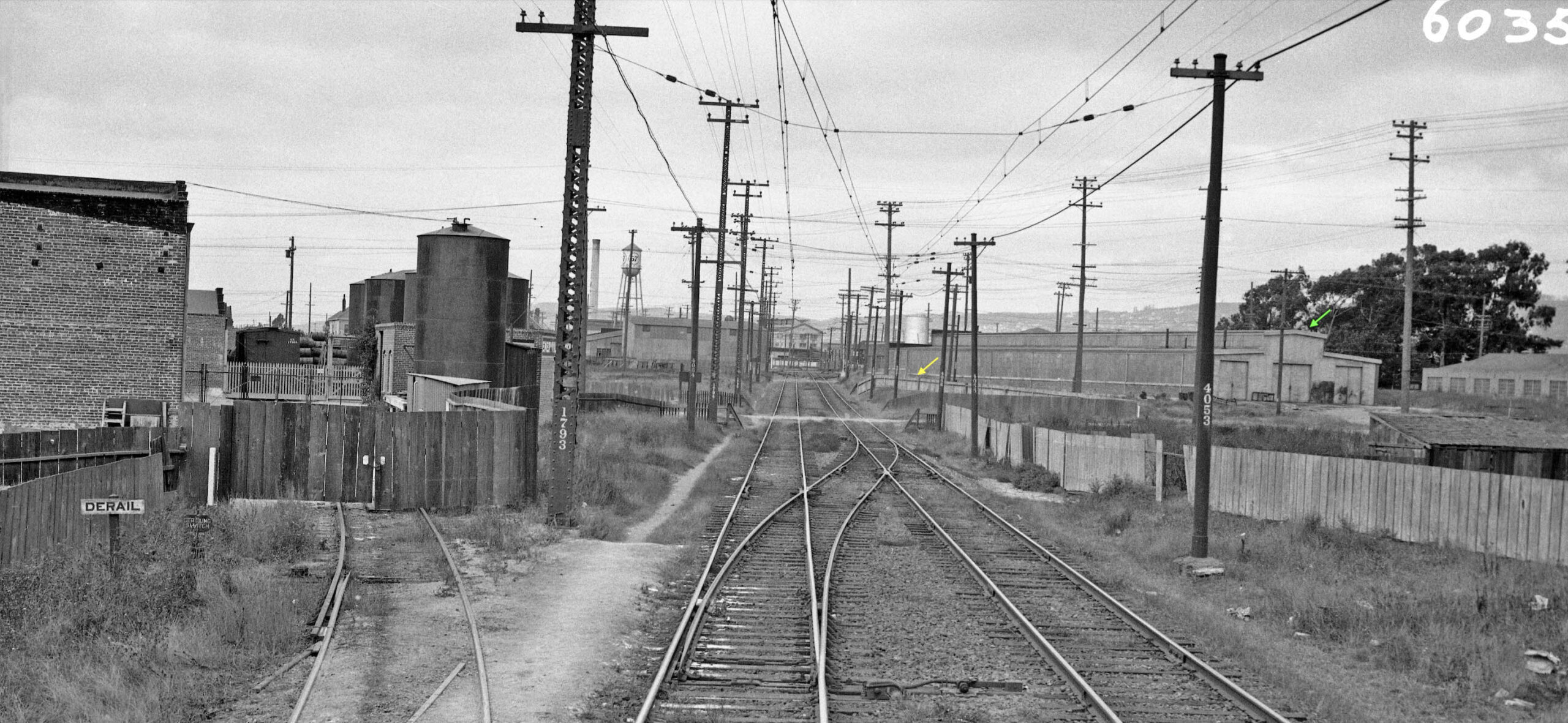
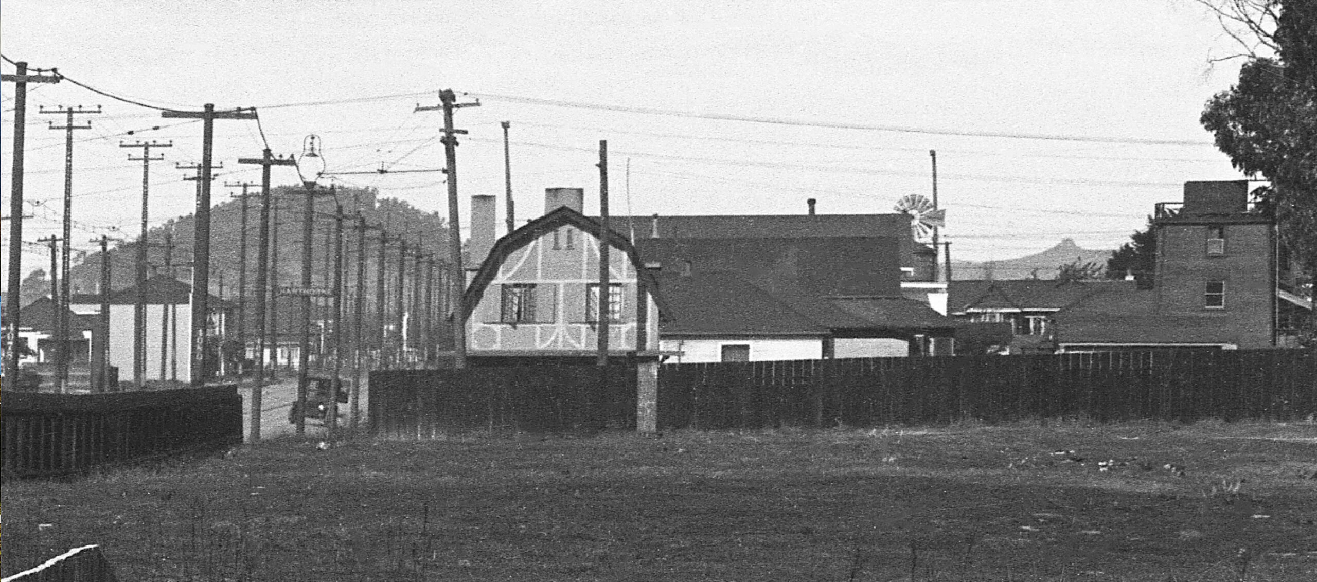
Next a ground view from the 1934 series taken by the SP showing the the Marchant Calculating Machine Co. factory and water tower, and the water tower for the Pacific Manifolding Book Co. The Shellmound stop, left edge, was actually before Ninth St. Junction, but this is the only ground shot found between 1923-1934 that shows where the Junction was located, marked by the red arrow. The building to the right of the red arrow still lines the beginning of the Greenway. The SP numbered every catenary and lattice pole to provide exact location of track.
L326-60-SP Photo, Vernon Sappers Collection, Courtesy BAERA, Western Railway Museum Archives, 170922oa&b, (Image 13 of 34)
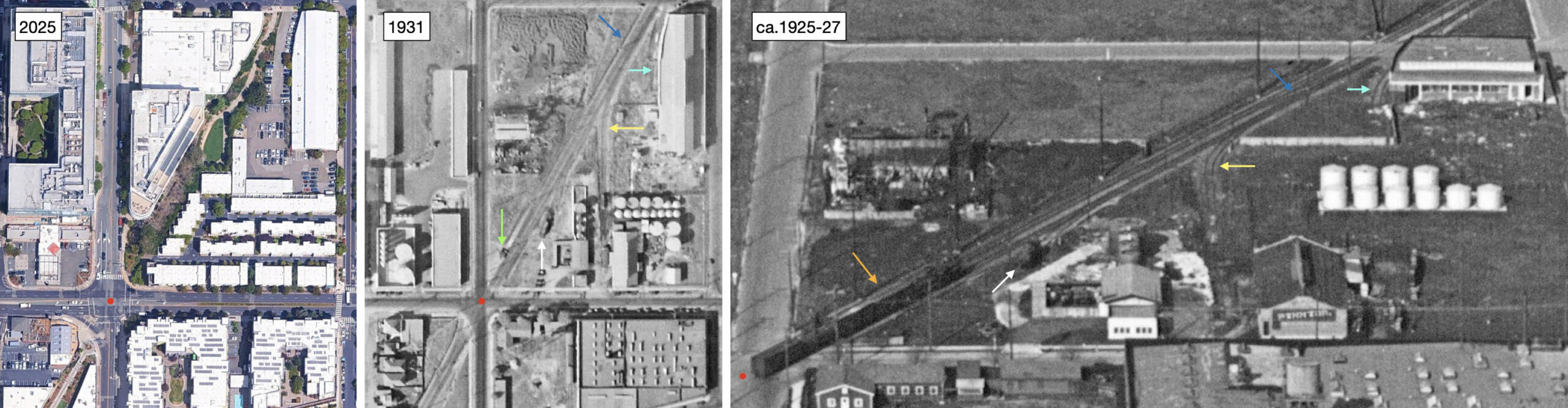
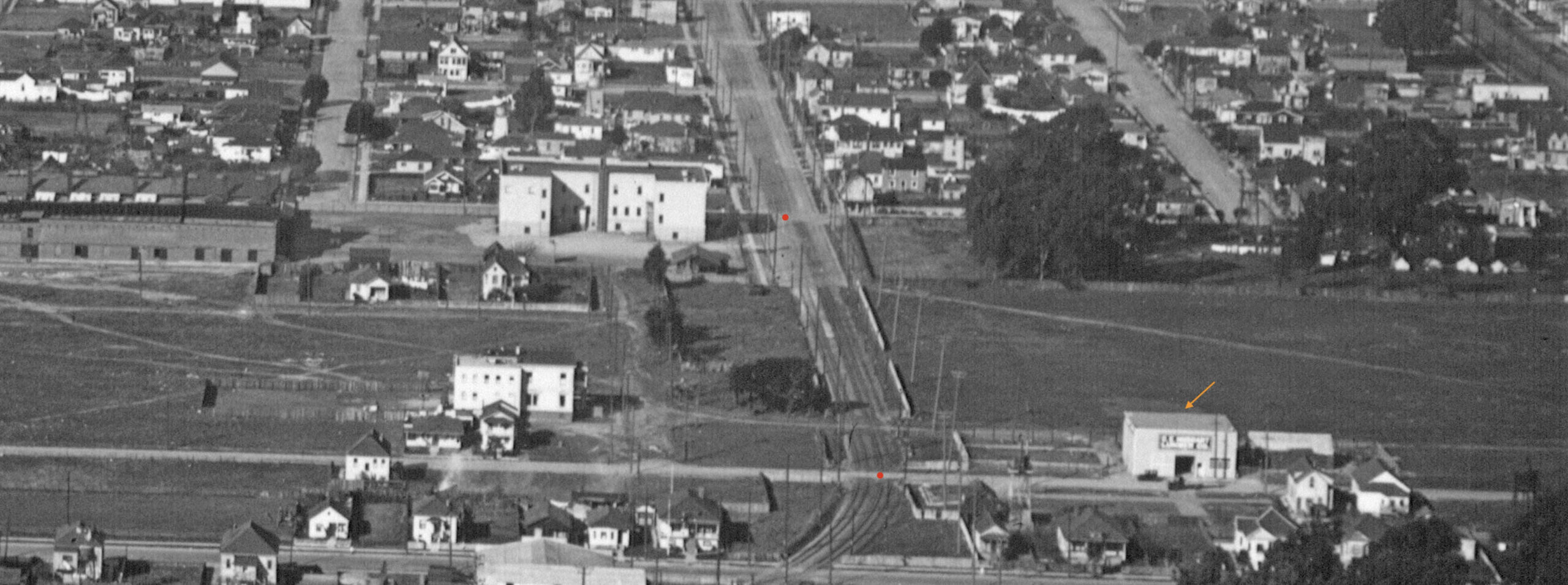
The next stop north, Powell St., red dot, and the green arrow, center, marking the station shelter are seen. A SP freight, orange arrow right, obscures the shelter. The yellow arrow marks a short spur to Pennzoil, the role of the siding with a locomotive, white arrow, has not been determined. The turquoise arrow, right panel, marks a spur to a building that was replaced by 1931, central panel, listed in a 1930 Sanborn as Industrial Steel Products, Ltd., but quickly thereafter Liberty Iron Works., Inc. The blue arrow marks the position of a crossover track.
L326-65-Courtesy Google Earth, l, c-1820_47, Courtesy of UCSB Library Geospatial Collection, c, George Russell Photo, Courtesy California State Lands Commission, SLC-642_NoDate_12, (Image 14 of 34)
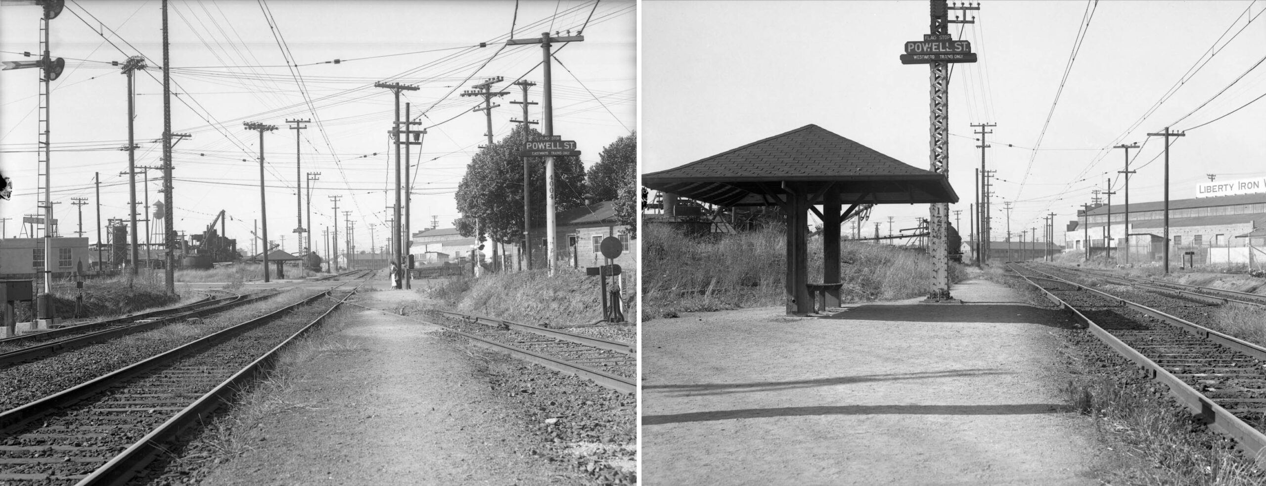
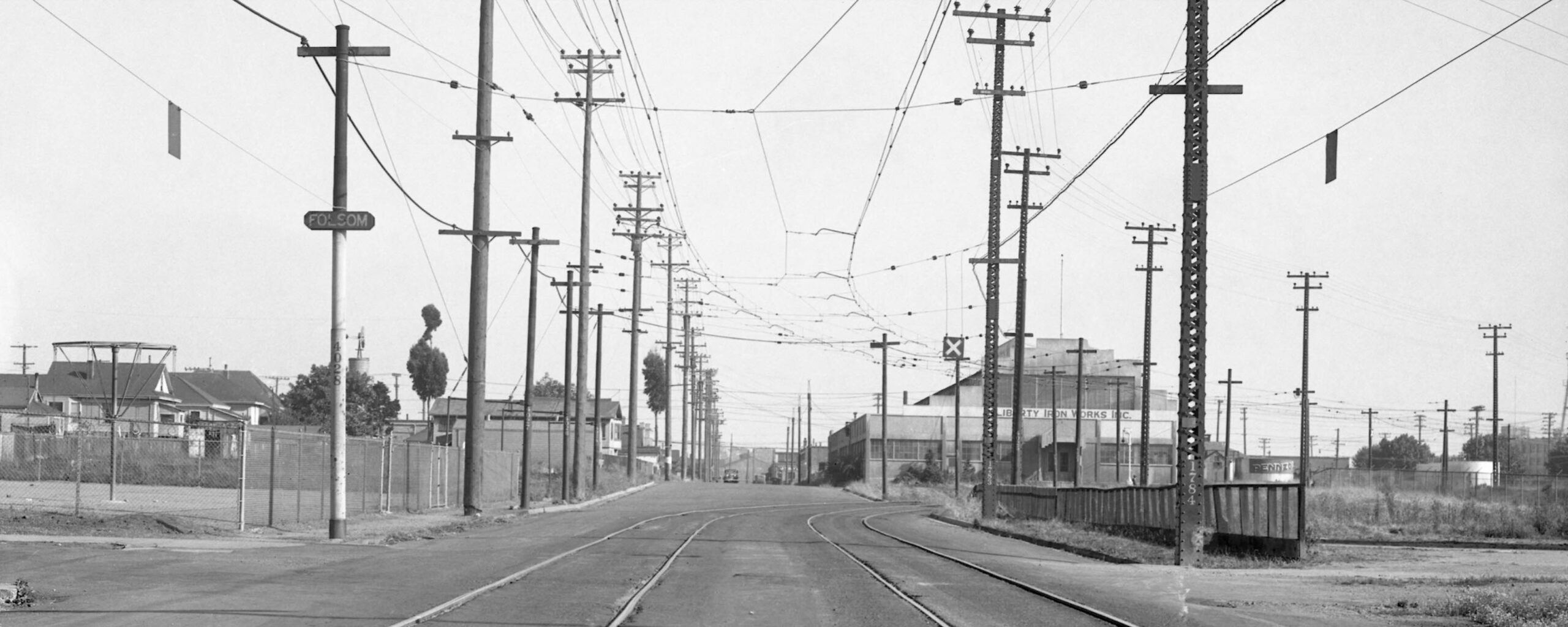
Two north views of the Powell St. stop and shelter from 1934 are presented. On the left, the left edge, west, reveals a building labelled Union Oil Co. that occupied the whole west side of Hollis St. between Powell and 59th Sts. with a spur leading from the SP. The spur coming in from the right was from Lubrium Laboratories Inc., at 5701 Green St., now Hollis St. On the right, the simple shelter, and the presence of Liberty Iron Works, Inc. at 59th and Doyle St just ahead. The destination of the spur past the shelter heading west has not been determined.
L326-70-SP Photo, Vernon Sappers Collection, Courtesy BAERA, Western Railway Museum Archives, 170923oa&b, l, 170924oa&b, r, (Image 15 of 34)
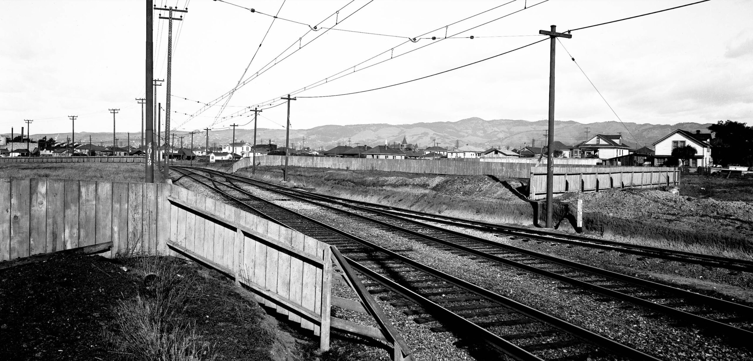
Next, the first SP official image from 1923, a northeast view of the track from Powell St. on the diagonal toward Doyle St. and 59th. The spur from Pennzoil can be seen on the right, and the crossover track in the center corresponding to what was seen in the previous aerials. As expected, the spot for the future site of Liberty Iron Works, Inc,. and the small structure that preceded it, are at this time an empty lot.
L326-75-SP Photo P-244, Vernon Sappers Collection, Courtesy BAERA, Western Railway Museum Archives, 76015oa&b, (Image 16 of 34)
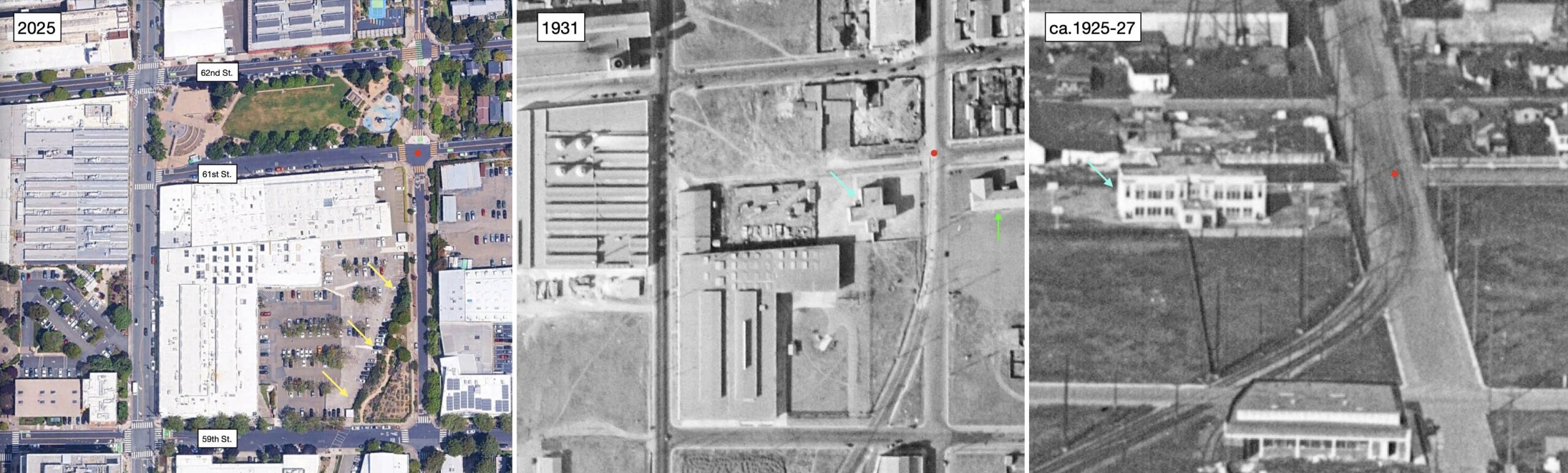
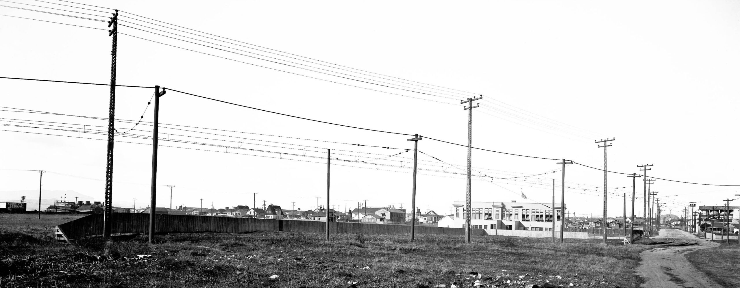
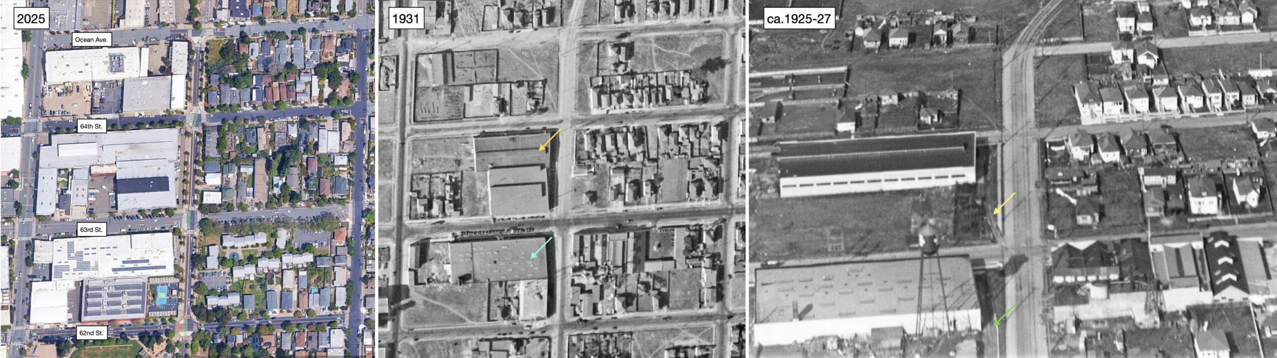
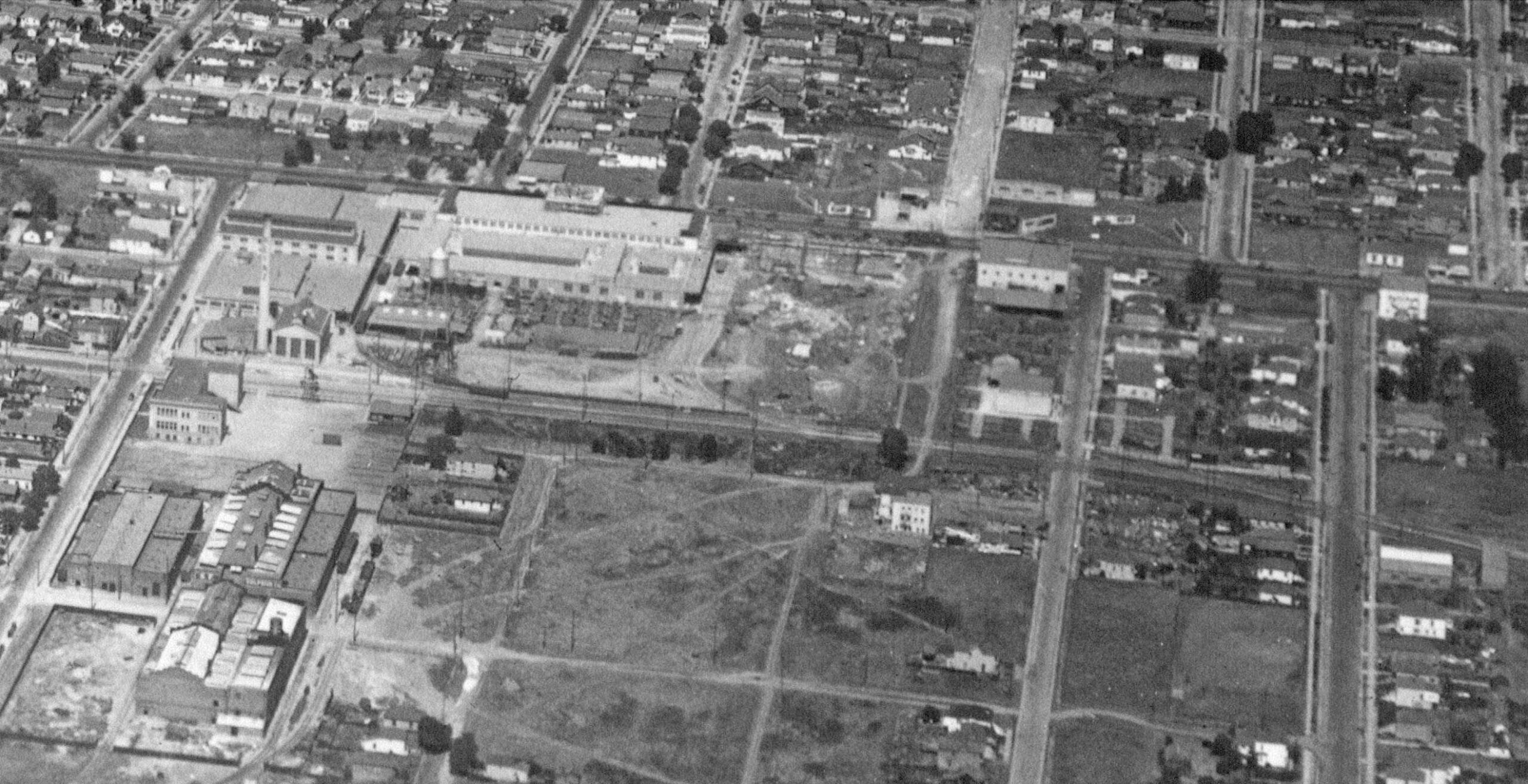
The curved edge of the parking lot in 2025, left, is explained by the private right-of-way the Ninth St. line cut between 59th St. and 61st St. to reach what was then called the Folsom St. stop, red dot. The tracks would then follow the asphalt as far north as Ocean Ave., but here shown only to 62nd St. The North Emeryville School, turquoise arrow, center and right, from 1910, would be replaced in 1929 by John A. Sutter Elementary that is present across Doyle St., and seen in its infancy in the center panel, green arrow, but yet to be built in the right panel.
L326-80-Courtesy Google Earth, l, c-1820_47, Courtesy of UCSB Library Geospatial Collection, c, George Russell Photo, Courtesy California State Lands Commission, SLC-642_NoDate_12, r, (Image 17 of 34)
Not much in the private cut between 59th and 61st Sts. ca. 1923 as seen in this north view save for the North Emeryville School.
L326-85-SP Photo P-243, Vernon Sappers Collection, Courtesy BAERA, Western Railway Museum Archives, 76016oa&b, (Image 18 of 34)
A south view from the Folsom stop from 1934 features the school yard on the left or east, and the Liberty Iron Works, Inc. building and a Pennzoil storage tank to the right or west at 59th St. Doyle St. is much narrower in 2025, and the addition of trees and vegetation block most of this view.
L326-90-SP Photo, Vernon Sappers Collection, Courtesy BAERA, Western Railway Museum Archives, 170925oa&b., (Image 19 of 34)
No ground images from the SP images for the section between 62nd St. to Ocean Ave. were found. It is an interesting section in that the two buildings first occupied by Western Waxed Paper Co., turquoise arrow, and Detroit Steel Products Co., orange arrow, are still in use, compare center image to left image, and both of these buildings had rail sidings as shown on the right marked with the green and yellow arrows, respectively.
L326-95-Courtesy Google Earth, l, c-1820_48, Courtesy of UCSB Library Geospatial Collection, c, George Russell Photo, Courtesy California State Lands Commission, SLC-642_NoDate_12, (Image 20 of 34)
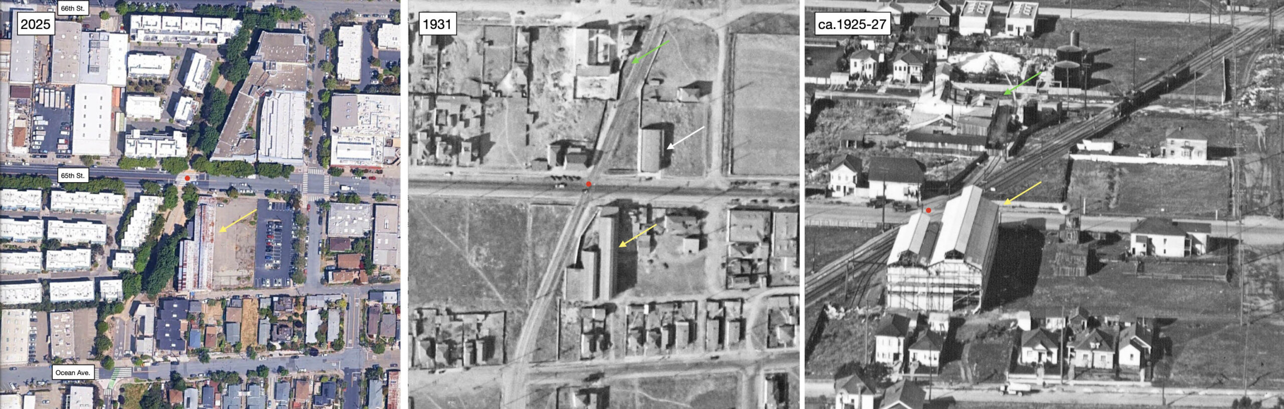
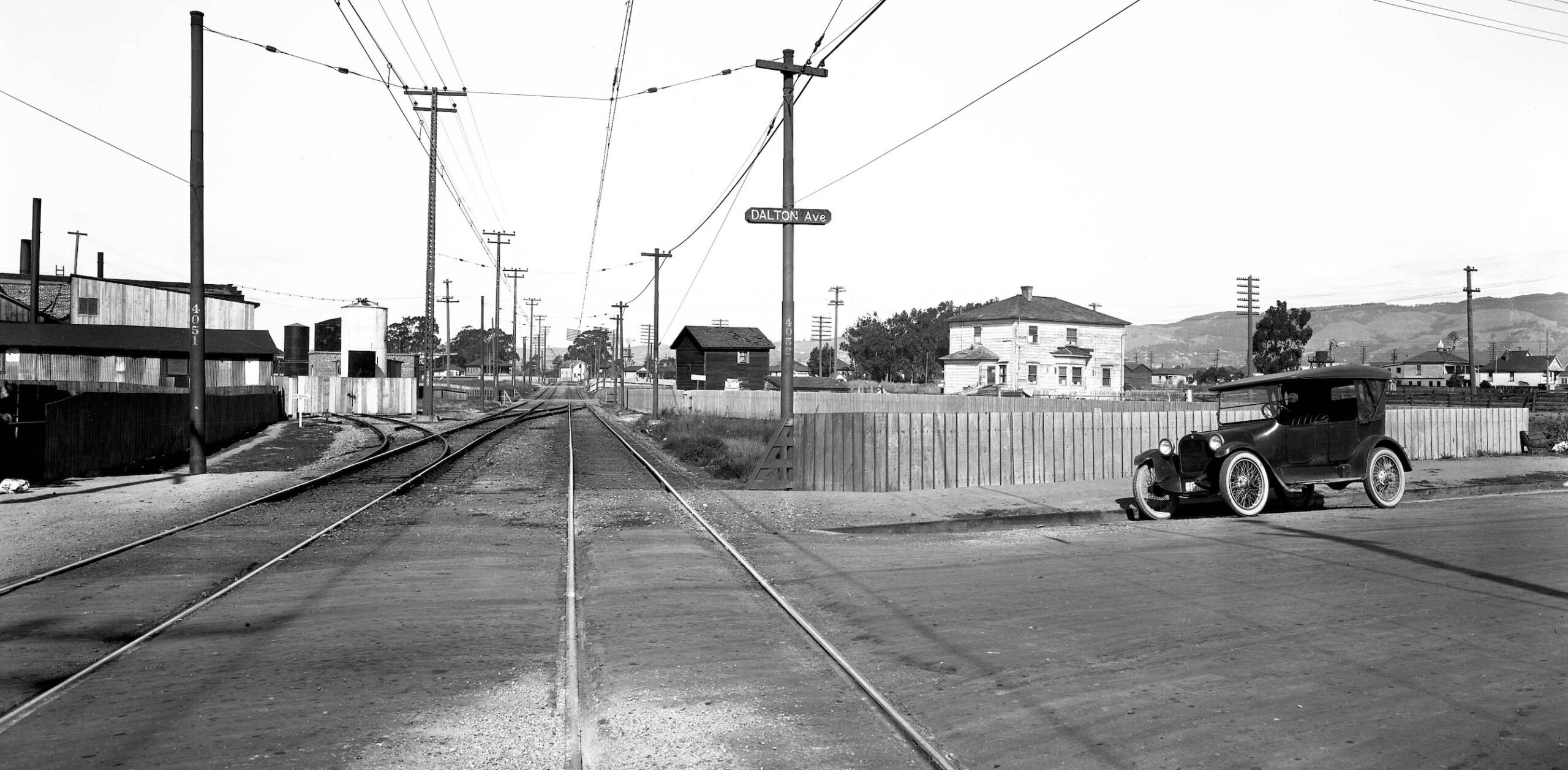
On to the next stop, Dalton Ave., now known as 65th St., red dot. A steam freight train, right top corner, is crossing 66th St. and materials for silicate of soda manufactured across the street by Emeryville Chemical Co., green arrow. This building has a spur track, as does the building marked by the yellow arrows being constructed for Janson Iron Works. A complex history for this building, but finally rumored to be converted to a 17 unit work-live space in 2025. The white arrow in the center points to Vitamin Concentrate Manufacturing Co.
L326-100-Courtesy Google Earth, l, c-1820_47, Courtesy of UCSB Library Geospatial Collection, c, George Russell Photo, Courtesy California State Lands Commission, SLC-642_NoDate_11, (Image 21 of 34)
A north view from south of the Dalton Ave. intersection from 1923. Emeryville Chemicals with its spur track stand out to the west of the track, as does an additional crossover track.
L326-105-SP Photo P-240, Vernon Sappers Collection, Courtesy BAERA, Western Railway Museum Archives, 76018oa&b, (Image 22 of 34)
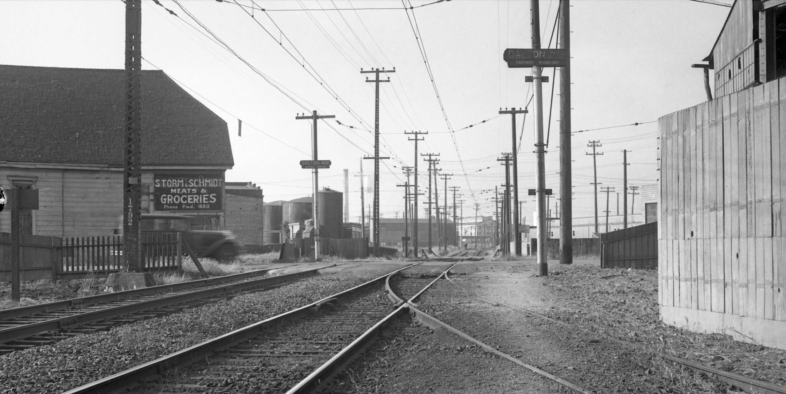
Next, a north view from 1934 from south of the Dalton Ave. intersection, the spur track coming in from the right or east from Janson is captured. Emeryville Chemicals is next to or north of the grocery.
L326-110-SP Photo, Vernon Sappers Collection, Courtesy BAERA, Western Railway Museum Archives, 170926oa&b, (Image 23 of 34)
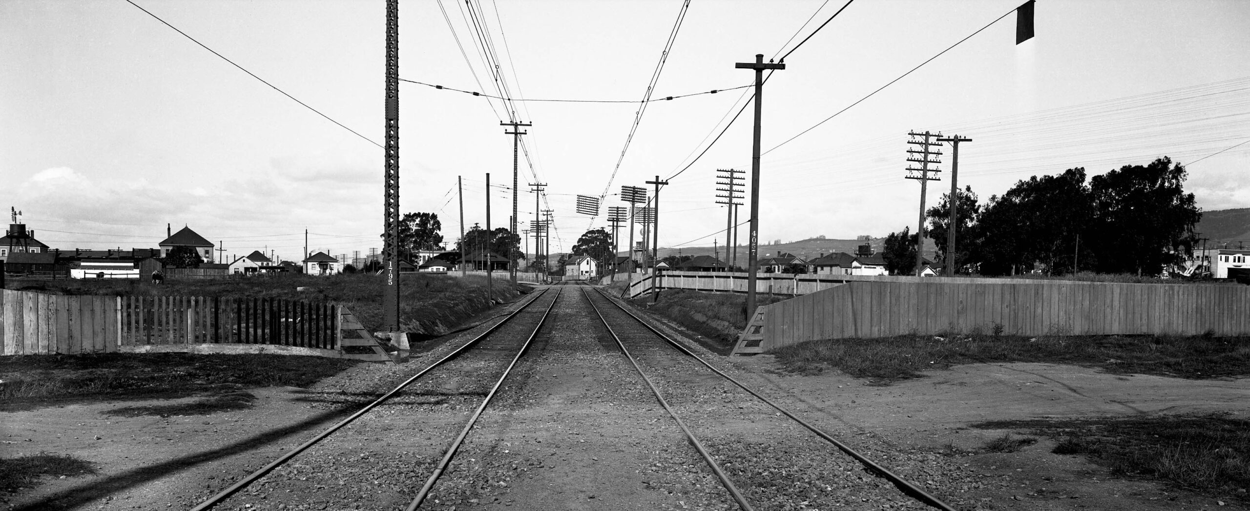
One block north at 66th St., this north view from 1923 toward 67th St. shows wide open territory.
L326-115-SP Photo P-239, Vernon Sappers Collection, Courtesy BAERA, Western Railway Museum Archives, 76019oa&b, (Image 24 of 34)
This is the only ground image in this update whose photographer history is an unknown. Taken from the rear of a westbound train just north of the Dalton Ave. intersection from Sept. 1933, the higher vantage point offers more track detail extending to 67th St. and the fence past 66th St., yellow arrow, matches up nicely with the previous image. The building to the east, green arrow, is F.A.B. Manufacturing Co.
L326-117-Courtesy BAERA, Western Railway Museum Archives, 233124oa&b, (Image 25 of 34)
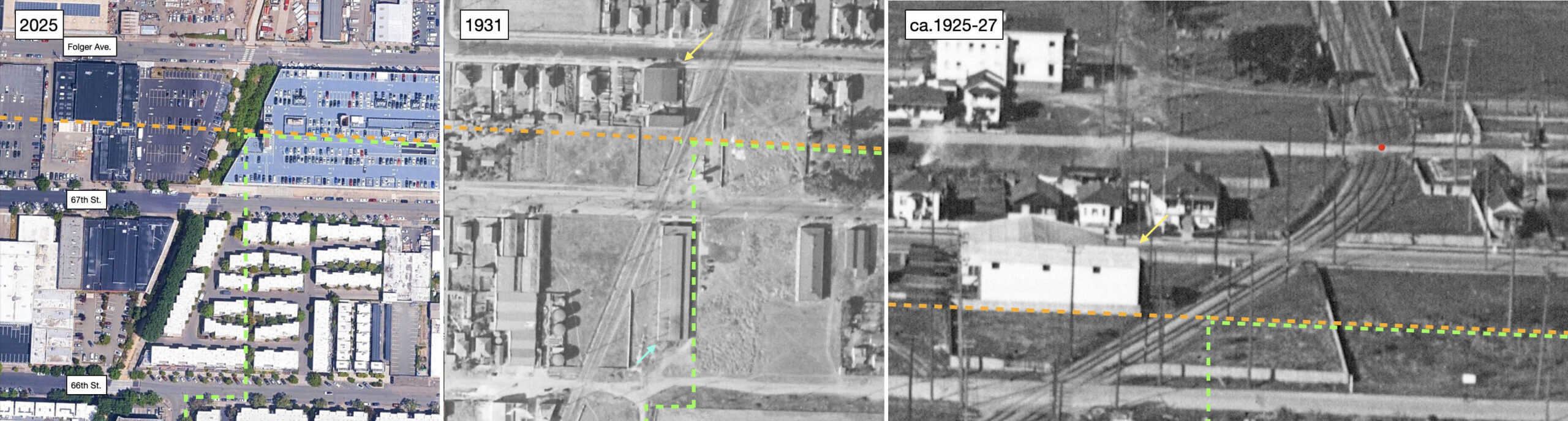
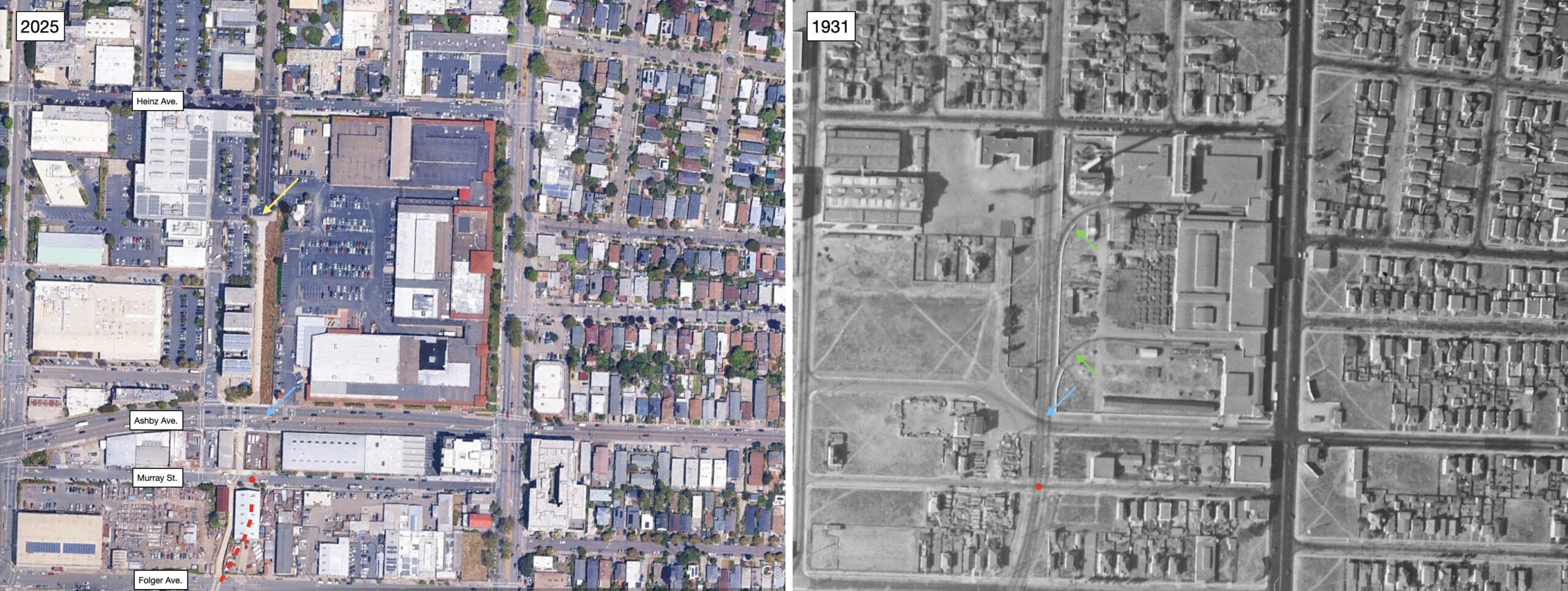
The aerials from 2025 and 1931 feature 66th St., 67th St. and Folger Ave. The orange broken line is the lower border of Berkeley, the green broken line the Oakland border. The turquoise arrow, center, points to auto chassis company F.A.B. Manufacturing Co. that was pictured in the last ground view. The yellow arrow points to Folger Ave. Mill and Lumber Co., at no. 940 Folger Ave. The permit for that building was filed in 1923 by then Grayson Owen Co. The oblique aerial from ca. 1925-1927 extends the view past Murray St., the next stop, red dot.
L326-120-Courtesy Google Earth, l, c-1820_48, Courtesy of UCSB Library Geospatial Collection, c, George Russell Photo, Courtesy California State Lands Commission, SLC-642_NoDate_11, (Image 26 of 34)
Continuing with north views along the Ninth St. right-of-way from 1923, a view from 67th St. past the Emeryville-Berkeley-Oakland borders or “three corners” to Folger Ave. in Berkeley. Every structure in this view is gone in 2025. Based on location, the Emeryville portion of the Greenway should become the Berkeley 9th St. Greenway at the border, but it is not so clear that it is the case nor does it matter. However, it is at this point that the current Greenway becomes shifted west of the actual train right-of-way. That will be more obvious shortly.
L326-125-SP Photo P-238, Vernon Sappers Collection, Courtesy BAERA, Western Railway Museum Archives, 76020oa&b, (Image 27 of 34)
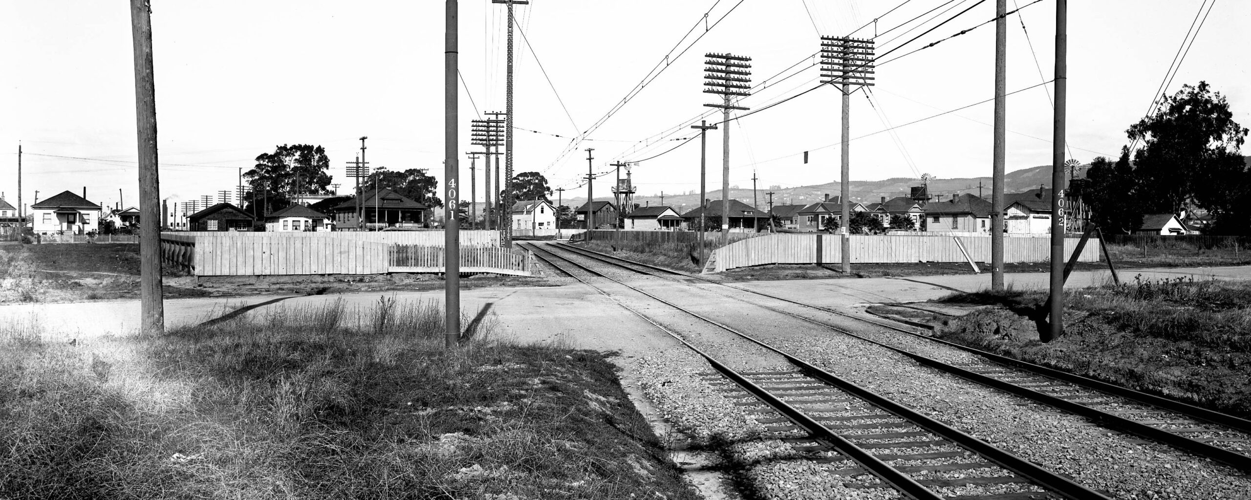
Ahead to 1934, and a south view from the Murray St. stop. The siding to the left was to C.E. Huddart Lumber Co. or a team track, Huddart no longer listed in the 1934 directory. Note the sign in the building with a sign for part of the slogan for Morton Salt. In the distance just to the right of the white storage tower the letters “A.B. Manufacturing” marks the F.A.B. plant. The Folger Ave. Mill and Lumber Co. is partially seen along the right edge, to the west of lattice pole no.1799.
L326-130-SP Photo, Vernon Sappers Collection, Courtesy BAERA, Western Railway Museum Archives, 170927oa&b, (Image 28 of 34)
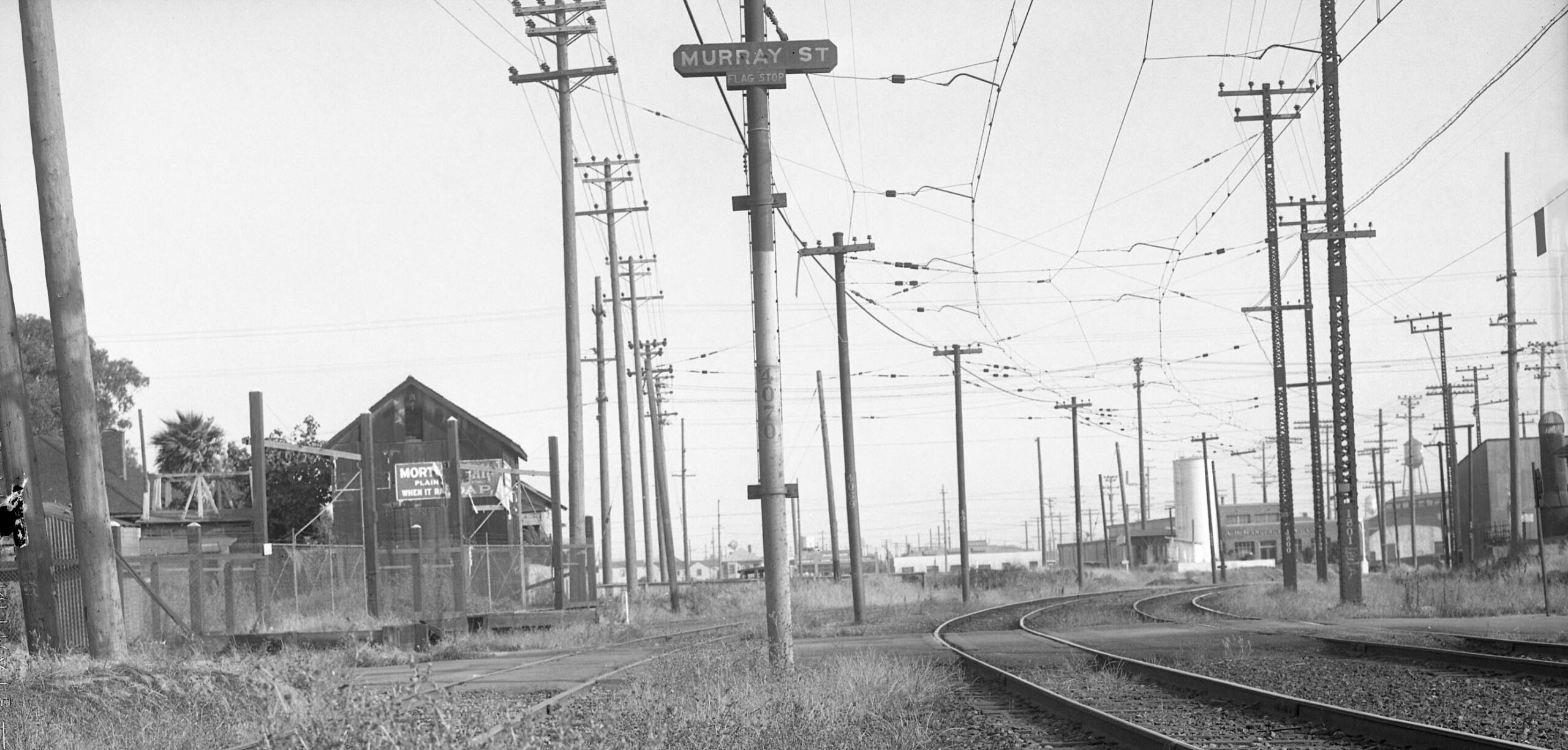
Continuing north on the Berkeley 9th St. Greenway, with the Murray St. stop, red dot. north of Folger Ave., the actual train right-of-way was a gentle left curve to the north, right, broken red line added on the left. The trail was produced around the blocking Berkeley Fire Warehouse. The yellow arrow, left, shows where the private “greenway” becomes Ninth St. On the right, two spurs enter the Heinz factory, green arrows, and the blue arrows in both images show how Ashby Ave. curved differently in 1931 west of Ninth St. Earlier views follow.
L326-135-Courtesy Google Earth, l, c-1820_48, Courtesy of UCSB Library Geospatial Collection, c, George Russell Photo, Courtesy California State Lands Commission, SLC-642_NoDate_11, (Image 29 of 34)
This northwest view along the right-of-way at Murray St. in 1923 shows a shuttered house west of the tracks at no. 2939 Ninth St. To the left of the house in the distance, buildings of the San Francisco Sulphur Company. To the right of the house in the distance, Hawthorne School from 1909 at no. 940 Snyder St., a Berkeley Public School, possibly a storage space at this time. East of the tracks alongside Albany Hill in the distance is no. 1001 Snyder Ave., renamed 1001 Heinz Ave. in 1928 once the company by that name was established here.
L326-140-SP Photo P-237, Vernon Sappers Collection, Courtesy BAERA, Western Railway Museum Archives, 76021oa&b, (Image 30 of 34)
This detail from the previous 1923 northwest provides a closer view of no. 1001 Heinz Ave., occupied in 2025 by Ecole Bilingue de Berkeley. First, note the SP Hawthorne station sign. Architectural historian Daniella Thompson determined it was designed by John Hudson Thomas in 1915 for Walter L. Thomas, superintendent of the San Francisco Sulphur Company, who didn’t live there. The store was a retail grocery in its early days, with the grocers living on the premises. Thomas rented the building, but eventually sold it, a private residence after 1926.
L326-145-SP Photo P-237, Vernon Sappers Collection, Courtesy BAERA, Western Railway Museum Archives, 76021oa&b, Detail, (Image 31 of 34)
This north view ca. 1925-1926 shows the Murray St. and Hawthorne stops, red dots, bottom and top, respectively. The shuttered house west of the tracks at no. 2939 Ninth St. is gone. The major addition to the area lining the tracks was C.E. Huddart Lumber Co. in 1925, orange arrow, mentioned previously in L326-130.
L326-150-George Russell Photo, Courtesy California State Lands Commission, SLC-642_NoDate_11, (Image 32 of 34)
George Russell took this east view over the emerging, but incomplete, Heinz plant. Susan Cerny notes the main building was built in three phases, between 1927 and 1928, click here for more. Charles S. Hughes Co. Building Materials was not yet constructed directly across Ninth St. Toward the bottom left are three buildings comprising San Francisco Sulphur Co. with its railroad spurs from the SP mainline along the Bay. The one to the far left, no. 2865 Seventh St. from 1906, is present in 2025. More on South Berkeley from the air in a future update.
L326-155-George Russell Photo, Courtesy California State Lands Commission, SLC_644_NoDate_22, (Image 33 of 34)
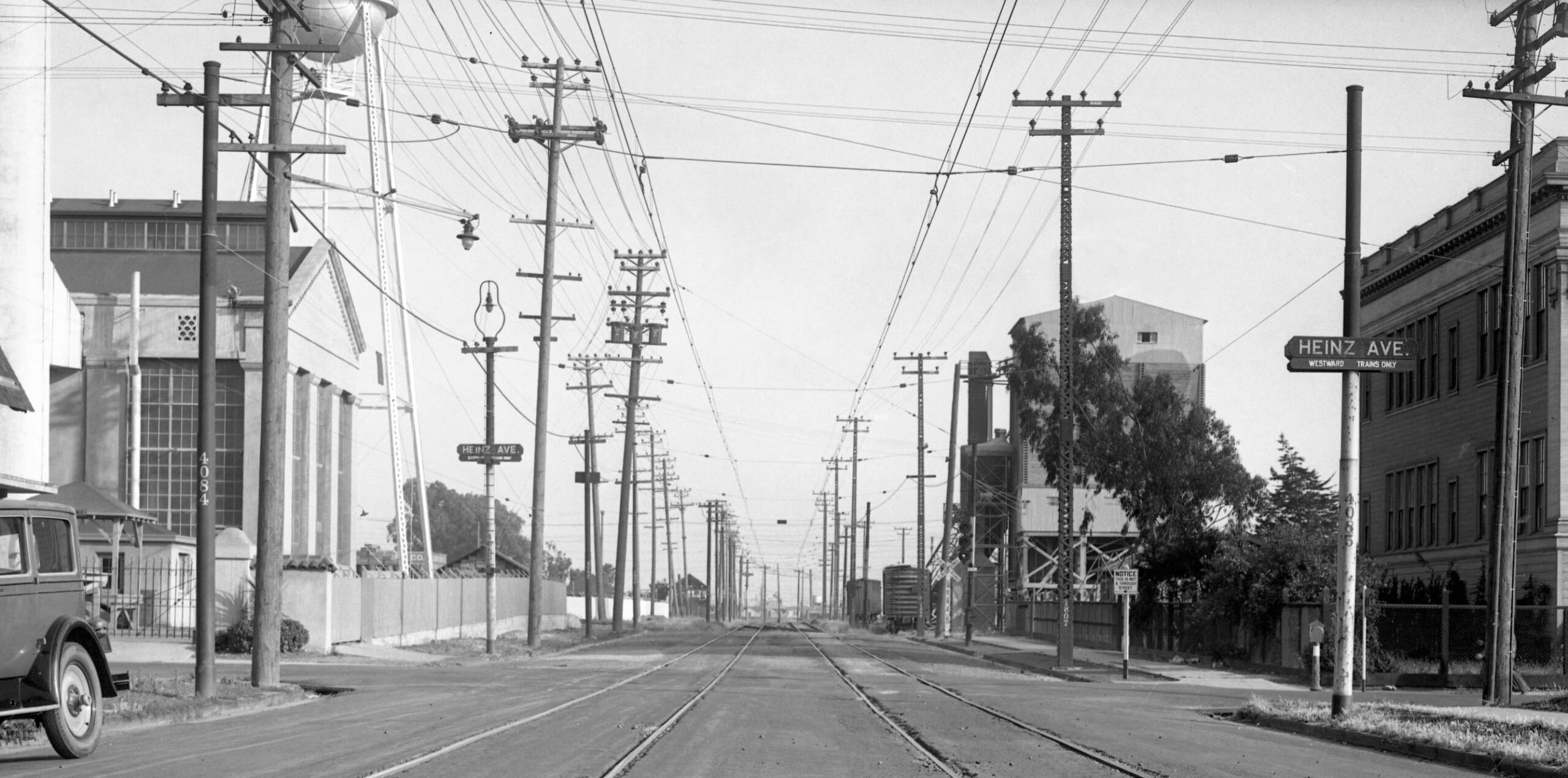
A south view from Heinz Ave. in 1934, the Heinz plant on the left, as well as in the former Hawthorne School building on the right. The school building was razed ca. 1960, and Berkeley Bowl West occupies the space in 2025. Charles S. Hughes Co. Building Material’s operation is to the south, marked by the two freight cars along the massive gravel conveyor. Appreciation to Daniella Thompson for all of the Berkeley building research. For more George Russell aerials of the area, click here. The Emeryville Historical Society has walking tours of the Greenway accessible from two links, click here, or, click here.
L326-160-SP Photo, Vernon Sappers Collection, Courtesy BAERA, Western Railway Museum Archives, 170928oa&b, (Image 34 of 34)