The Frickstad Viaduct and the Evolution of the 12th St. Dam
The roadway in downtown Oakland that spanned over the dam holding water in Lake Merritt had been traditionally known as the 12th St. dam. The Frickstad Viaduct, “Viaduct”, was a major modification to the original road design implemented to handle the vast increase in vehicular and streetcar traffic over the dam in the decades preceding its opening on June 16, 1953. This update will review the 100 year background of the 12th St. dam and the surrounding neighborhood before the Viaduct was built.
L329-05-Courtesy Oakland Cultural Heritage Survey, Oakland City Planning Dept., (Image 1 of 26)

The talking points for the next several updates will follow the evolution of the road configuration seen in the 1938 aerial versus that in the 1965 aerial. The Viaduct hastened the removal of the remaining Key link to East Oakland, and provided only underground passage ways to access Lake Merritt from the Oakland Civic Auditorium, the Kaiser Center of the Arts in 2025. The subjugation of pedestrian traffic to improve vehicular movement eventually fueled the action to remove the Viaduct’s footprint, begun in May 2010 to create the simpler configuration seen on the right.
L329-10-Harrison Ryker Photo V5-142, Courtesy California Department of Transportation, l, cas-65-130_15-113, Courtesy of UCSB Library Geospatial Collection, c, and Google Maps, r, (Image 2 of 26)
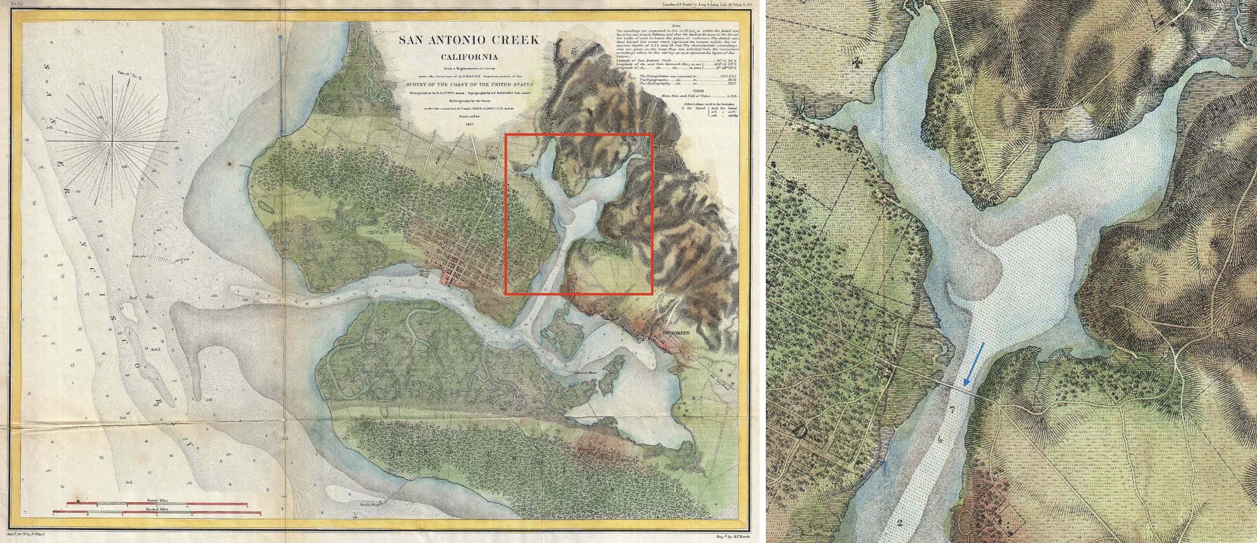
This map from 1857, left, shows that only a single crossing of the tidal canal connected Oakland to Clinton, enlarged on right. Horace Carpentier, unscrupulous cofounder and first mayor of Oakland from 1854-1855, agreed in 1853 to complete the 1350 ft. drawbridge when the city lacked the funds to do so. In return, to recoup his losses and that of the builder, T.C. Gilman, he was allowed to collect a toll, 12 cents per person or 25 cents on horseback, exorbitant relative to the 5 cent ferry from San Francisco to Oakland. Under pressure, he sold the bridge that was to cost $7000 to the county in 1857, walking away with toll profits and $50k from taxpayers, and leaving Gilman in the lurch.
L329-15-United States Coast Survey, Public domain, via Wikimedia Commons., (Image 3 of 26)
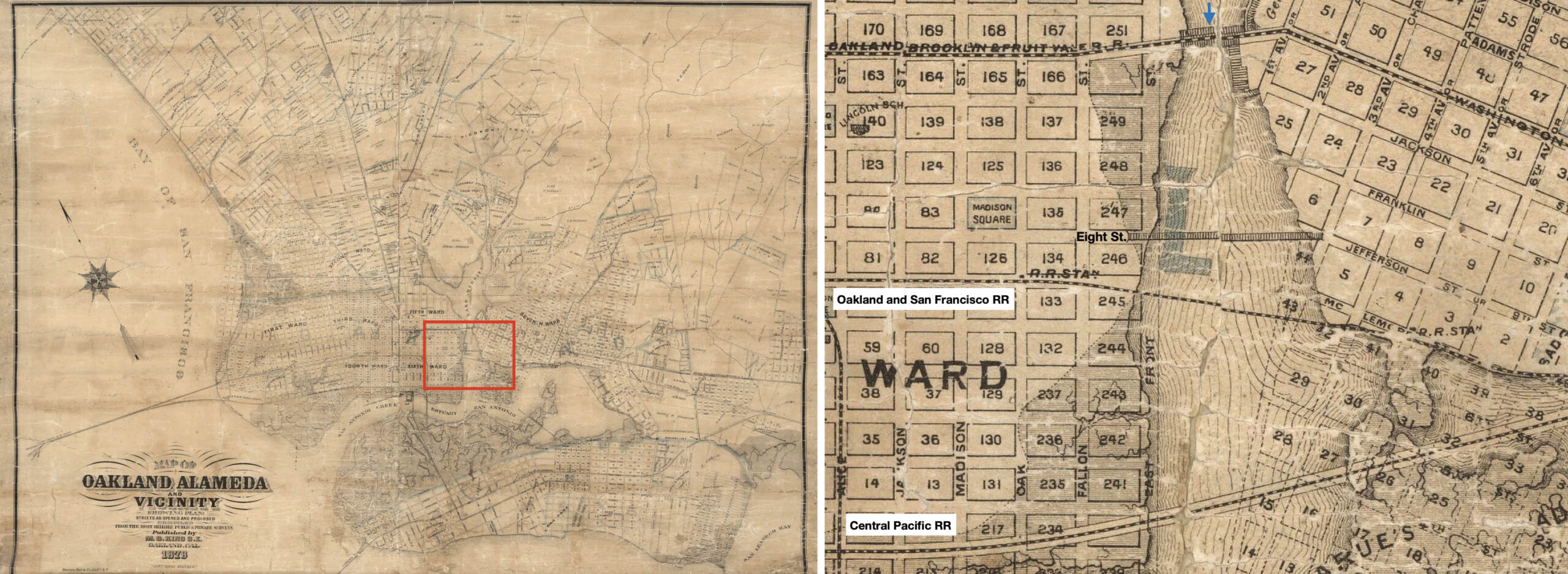
By 1876, an additional crossing at 8th St. had been added, as well as two for steam rail lines. Samuel Merritt was mayor from 1868-1869, a doctor by training, but a real estate investor with holdings that included 40 acres around the lake. He directed construction of the dam at 12th St., blue arrow, to create the lake never officially named after him. He spearhead the drive to make the lake a wildlife refuge in 1870, the first of its kind to be governmentally designated in the US. All of this was for his personal gain, as the refuge banned hunting, and encouraged homes to be built along the shore on land that he would sell. Onto streetcars next …
L329-20-Courtesy David Rumsey Map Collection, David Rumsey Map Center, Stanford Libraries, (Image 4 of 26)
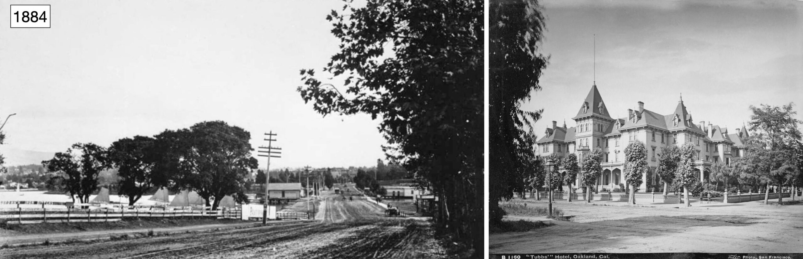
By 1872, the first horse-drawn streetcar was assembled across the 12th St. dam, the Oakland, Brooklyn and Fruit Vale Railroad, left, southeast view. Locally it was known as the “Tubbs Line” after its owner, Hiram Tubbs, who owned the Tubbs Hotel, right, at newly renamed E. 12th St. and 4th Ave., reflecting the annexation of Brooklyn into Oakland that year. The hotel burned down in 1893. Tubbs had already sold the line in 1885, and the single-track, narrow-gauge, non-electrified line was abandoned in 1895 according to Sappers’ “Key System Streetcars”, Signature Press, 2007.
L329-25-From the Joseph R. Knowland collection at the Oakland History Room, Oakland Public Library, copl_044 Neg. 209, l, I. Taber Photo, Courtesy California State Library, r, (Image 5 of 26)
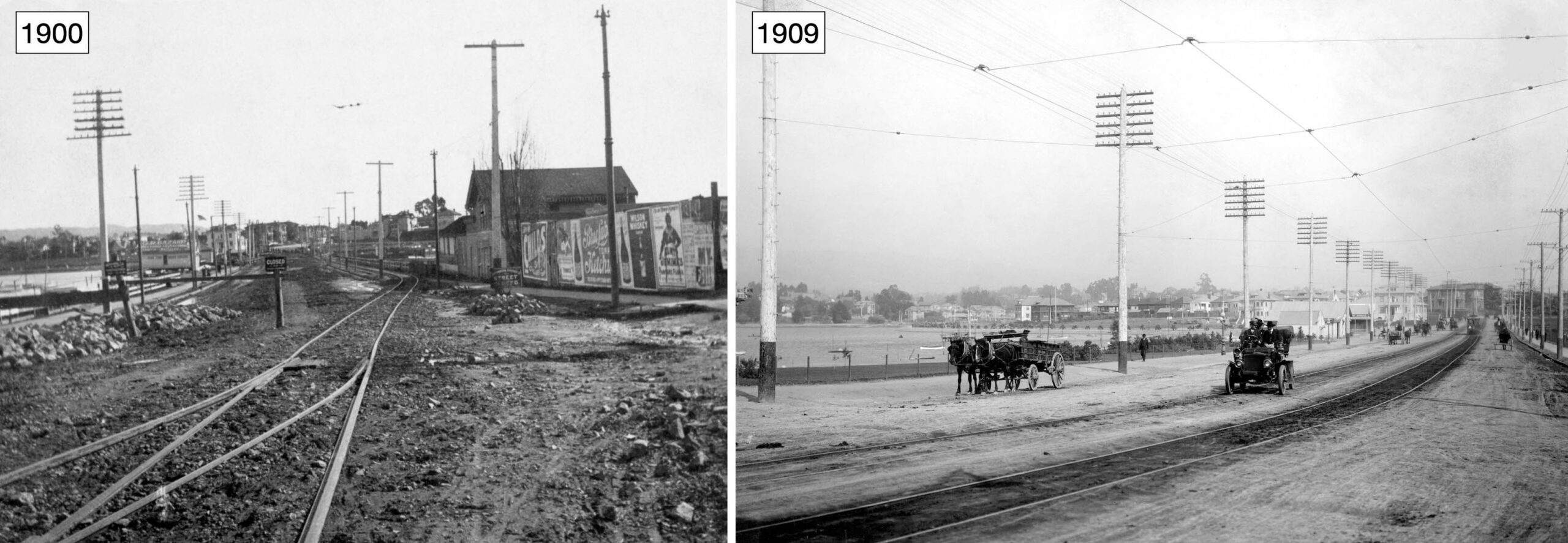
By 1900, the 12th St. dam was in bad shape, the abandoned track still in place in this southeast view, left. All ripe pickings for Borax Smith, who soon took over the route and placed two standard gauge tracks with overhead wire for electric streetcars and interurbans, right, southeast view 1909. In exchange for the deed to Lake Merritt gratis from the Central Pacific’s Collis Huntington ca. 1893, the city was to improve the roadway. The paving and final widening effort did not occur to the 12th St. dam until 1915.
L329-30-Courtesy BAERA, Western Railway Museum Archives, W. E. Gardiner Photo, Erle Hanson Collection, 93944ks, l, Erle Hanson Collection, 130076ks, r, (Image 6 of 26)
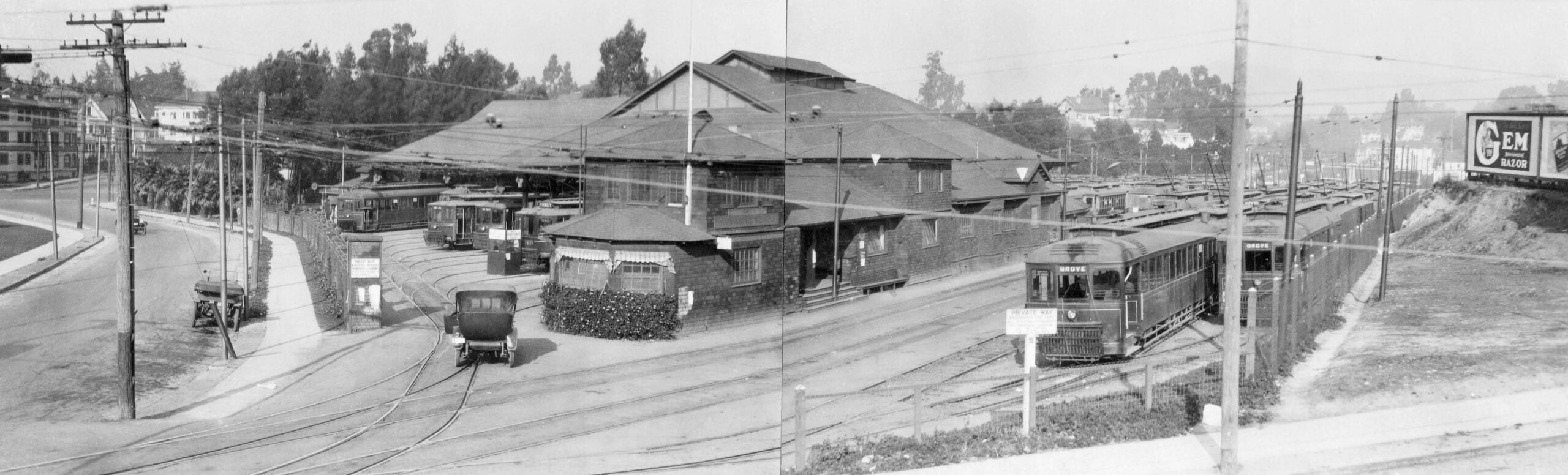
Now having access across the 12th St. dam and backed by Realty Syndicate clout, Smith’s Oakland Traction Co. consolidated five car houses of predecessor companies and constructed the Central Car House in the Craftsman style in 1905 between E. 18th and E. 16th Sts. (the latter now Foothill Blvd.,) and 2nd and 3rd Aves. Initially, eleven lines used the facility. Northeast view from Oct. 1919.
L329-35-Erle Hanson Collection, Courtesy BAERA, Western Railway Museum Archives, 130650ks, (Image 7 of 26)
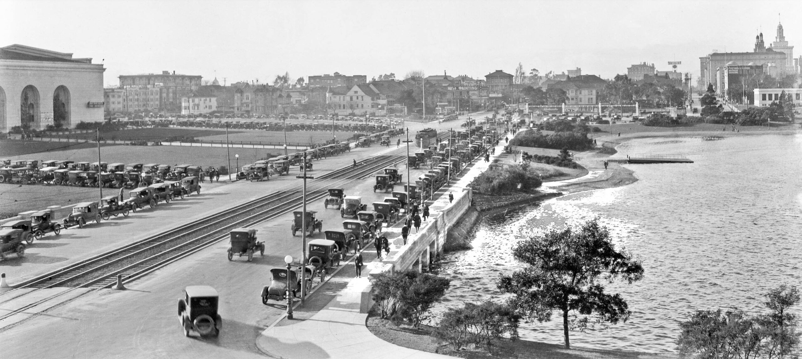
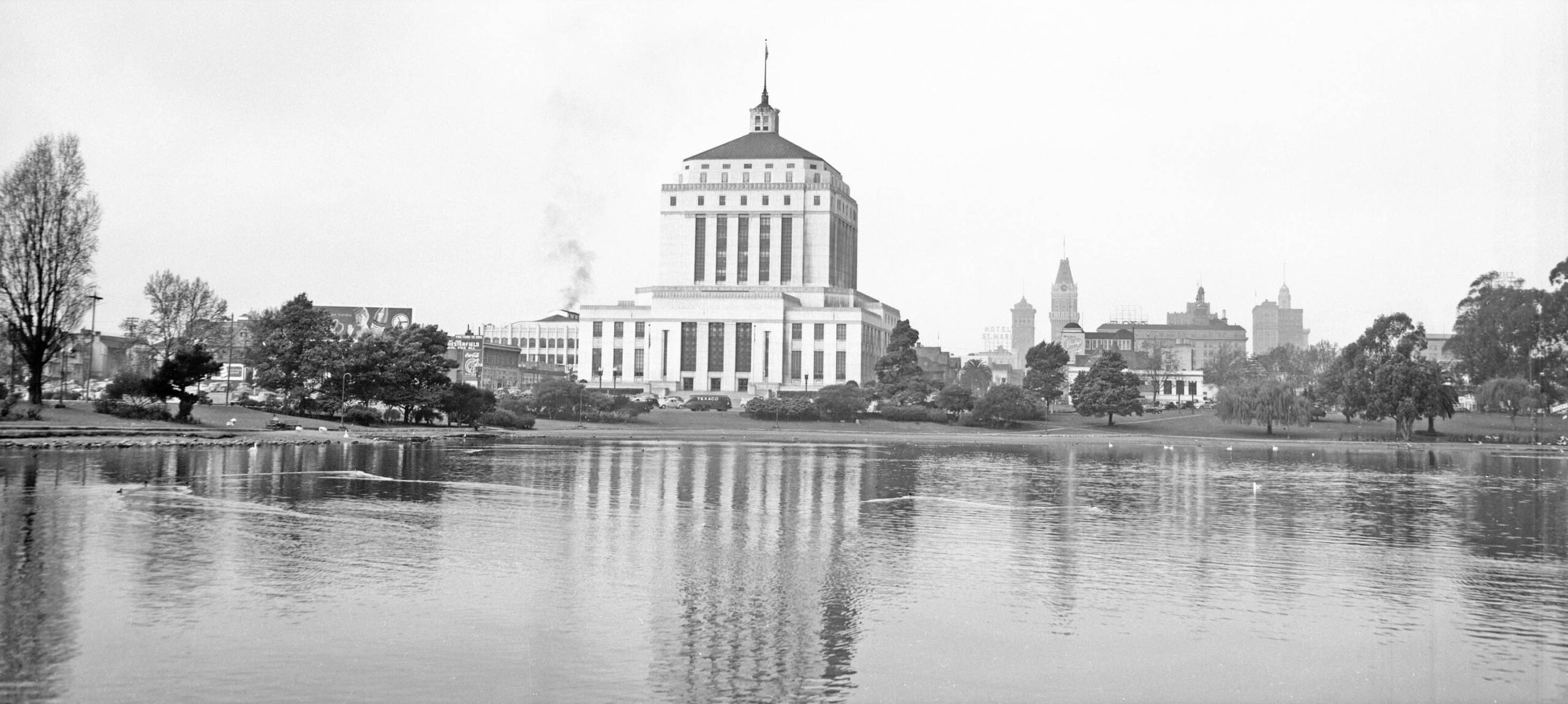
Before, left, and during, right, the Great Depression, the 12th St. dam was a busy place as seen in these southeast views. In the right panel, the building in the lower left and the higher elevation at which the image was taken indicate the construction of the Alameda County Superior Courthouse was in progress. Note also the presence of the Oakland Unified School District headquarters in the upper right of the same image, another useful marker for dating purposes.
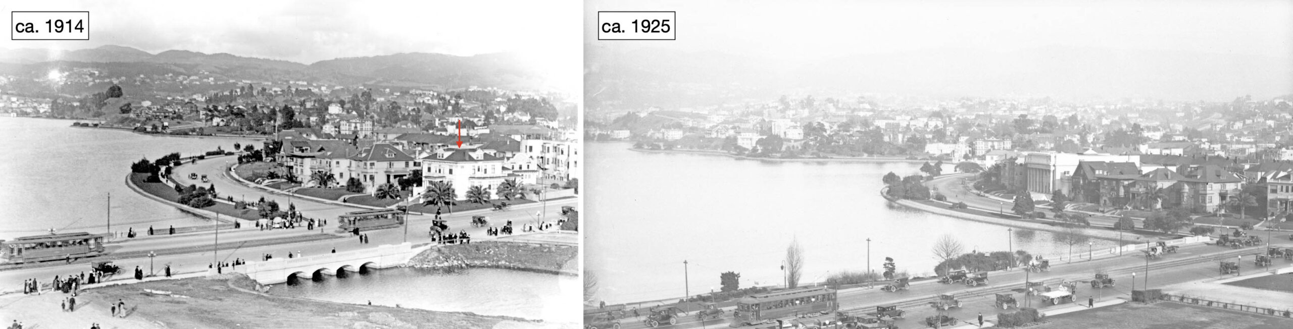
L329-40-Vernon Sappers Collection, Courtesy BAERA, Western Railway Museum Archives, 24711ks l, 24709ks, r, (Image 8 of 26)
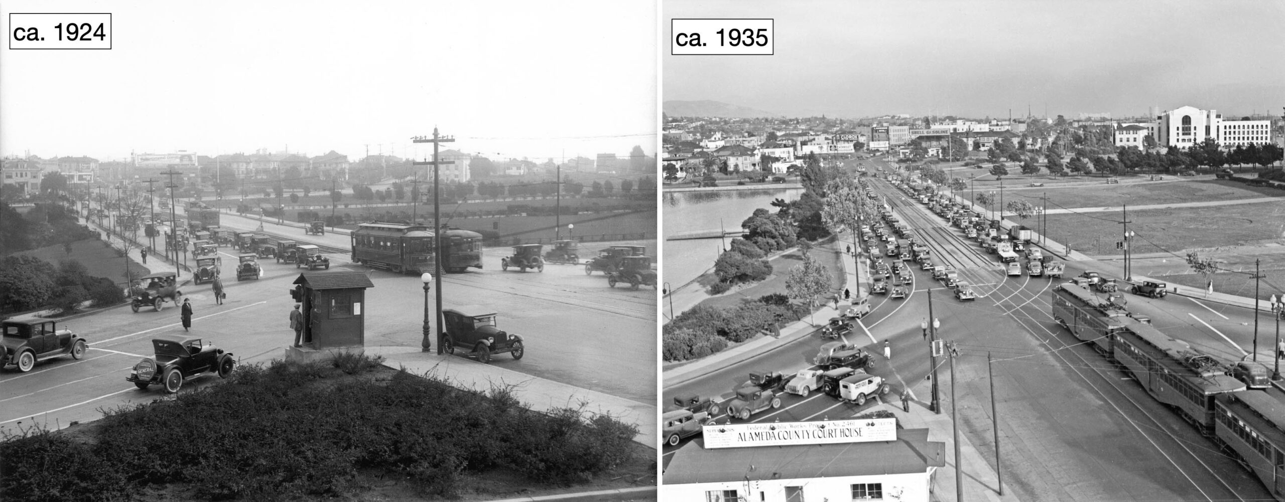
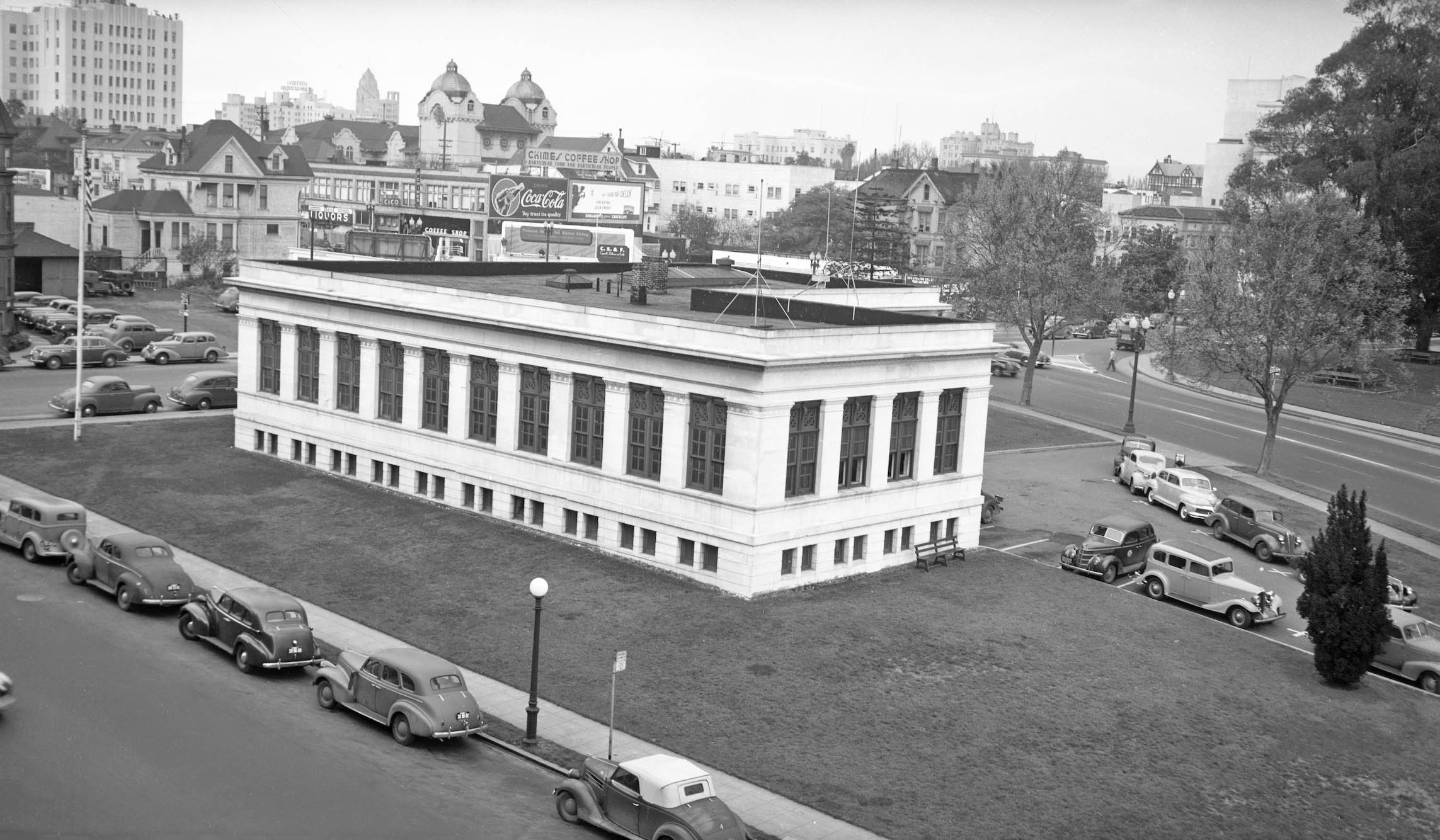
A complementary northwest view ca. 1924 shows the Oakland Civic Auditorium along the left margin. The absence of the courthouse makes the image seem out of place, but the buildings along the right margin, including City Hall, are all too familiar, even in 2025.
L329-45-Jeffrey Moreau Collection, Courtesy BAERA, Western Railway Museum Archives, 82609ks, (Image 9 of 26)
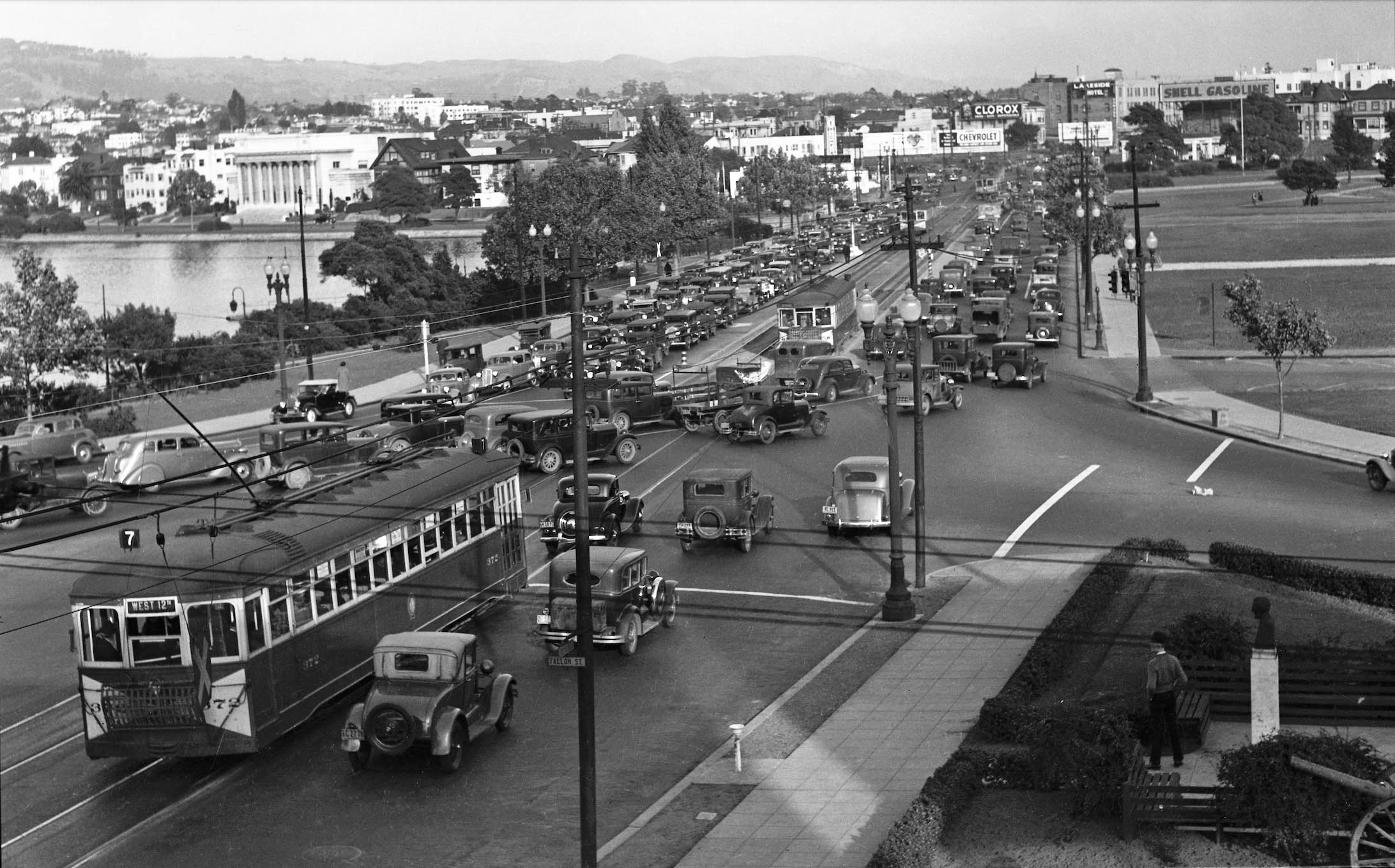
So the problem was clear, this southeast view from 1930 illustrating the logjam produced by the auto and streetcar-interurban rail traffic. A plan was needed, but it not would be until after WWII that a proposal was in the works. As an aside, the classical architecture of the Fourth Church of Christ, Scientist, built in 1923 stands out along the east side of the lake in the upper left.
L329-50-Vernon Sappers Collection, Courtesy BAERA, Western Railway Museum Archives, 24706ks, (Image 10 of 26)
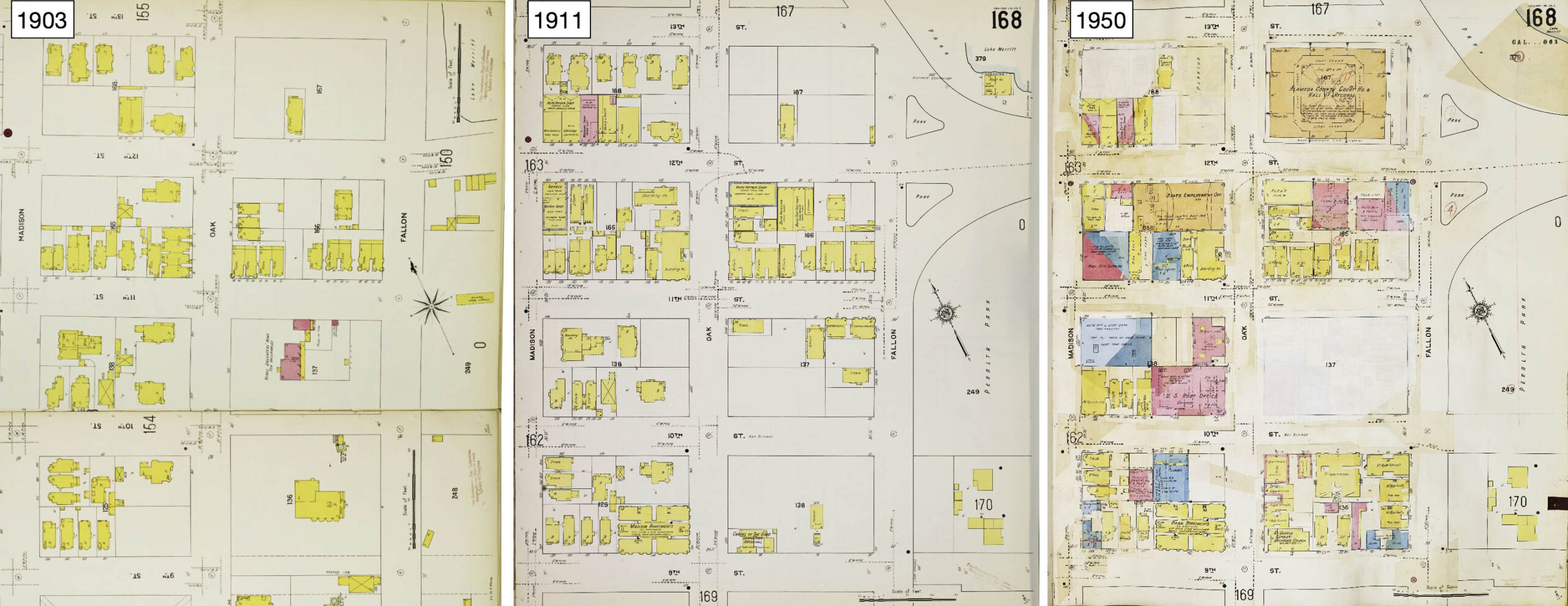
Before considering what was to be done with the 12th St. dam, some knowledge of the evolution of the neighborhoods on either side of the structure are in order. Starting with Sanborn maps, the area east of the lake from 9th-13th Sts. had been fairly well developed with residences even before the great migration from the 1906 earthquake, comparing 1903 to 1911, respectively. The 1950 map, right, shows a large change to a highly commercial area with government-related buildings.
L329-55-Courtesy Library of Congress, Geography and Map Division, Sanborn Maps Collection, 1903, Vol. 2, l, 1911, Vol. 2, c, 1911-1950, Vol. 2, r, (Image 11 of 26)
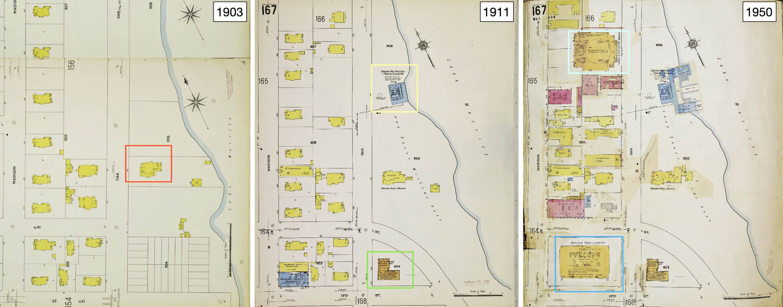
For 13th St. and north, the Sanborn from 1903, left, reveals a residential area with the Camron-Stanford House, red box, from 1876, the last of the Mayor Merritt-era 19th-century Victorian mansions around the lake. In 1907, the mansion became the city’s first museum, the Oakland Public Museum, central panel, joined by the Electrical Dept., City of Oakland or Fire Alarm Building in 1911, to the south, green box, and the Municipal Boathouse-Oakland High Pressure Station in 1909, yellow box. By 1950, right, add the brand new Main Library, blue box, the Temple of Scottish Rites Masonry in 1927, turquoise box, the addition of the wings to the boat house in 1913, and the increase in the size of museum.
L329-60-Courtesy Library of Congress, Geography and Map Division, Sanborn Maps Collection, 1903, Vol. 2, l, 1911, Vol. 2, c, 1911-1950, Vol. 2, r, (Image 12 of 26)
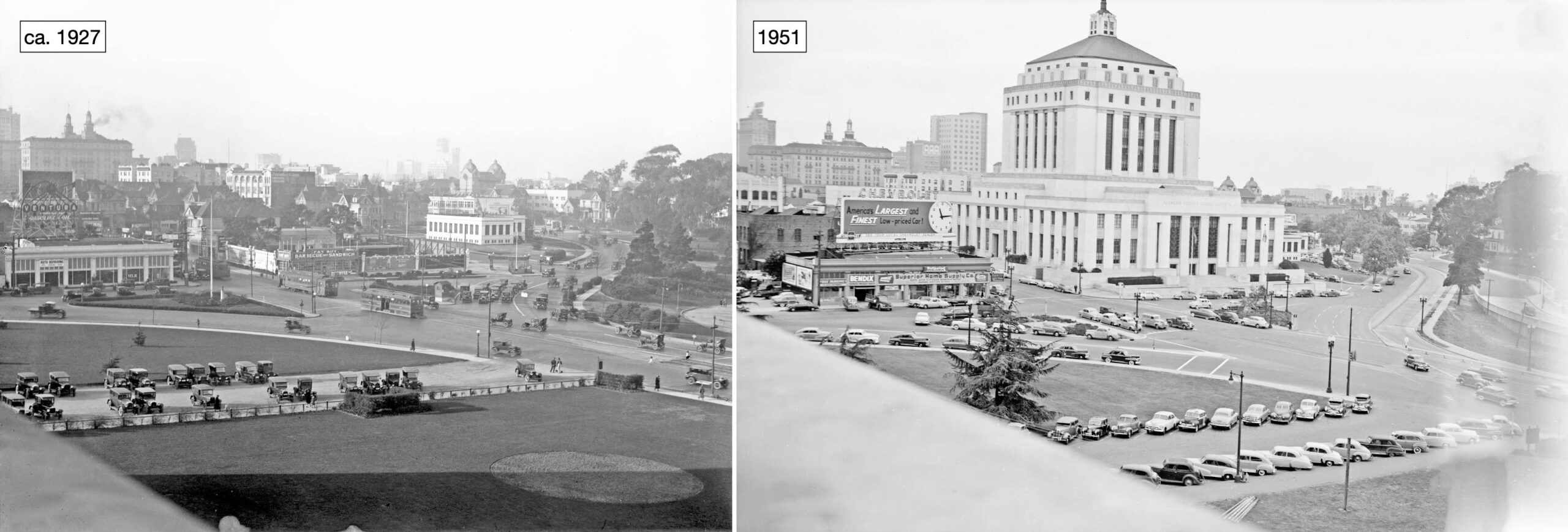
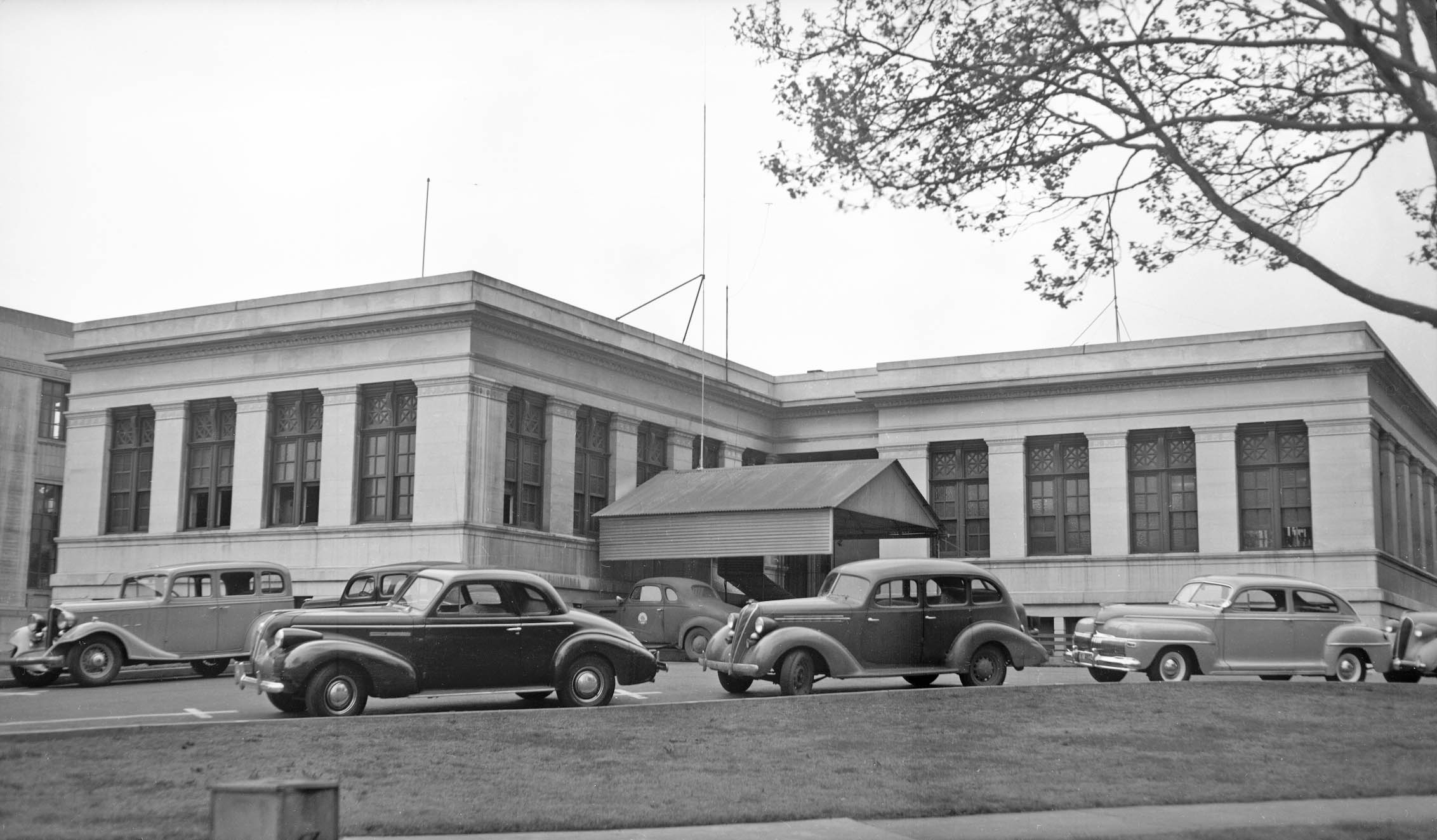
The addition of the courthouse in the mid-1930s eliminated any possibility of a Viaduct running straight through 12th St. This is appreciated in these northwest views from the roof of the Oakland Civic Auditorium from 1927, left, versus, Apr. 17, 1951, right.
L329-65-Courtesy BAERA, Western Railway Museum Archives, 11533ks, l, Dept. of Public Works, City of Oakland, 35982ov, r, (Image 13 of 26)
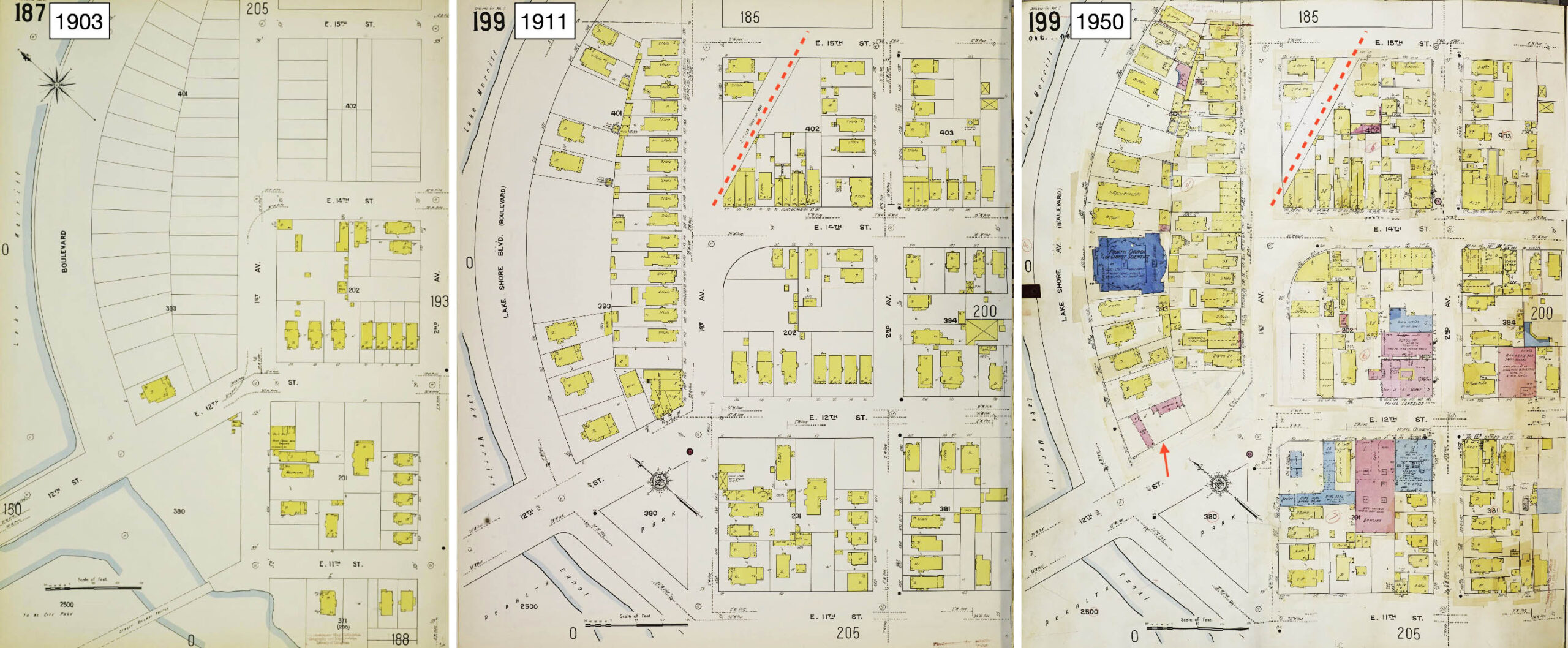
In contrast to the west side of the crossing, the east side saw tremendous residential growth after the earthquake, 1911 vs. 1903, with storefronts along the north side of E. 14th St. and the addition of the Key private right-of-way to the new car house, red broken line. By 1950, right, 12th St. saw addition of hotels such as the Olympic and Lakeside, and additional commercial businesses. The red arrow marks a gas station that replaced a house sometime before 1946, to be shown next.
L329-70-Courtesy Library of Congress, Geography and Map Division, Sanborn Maps Collection, 1903, Vol. 2, l, 1911, Vol. 2, c, 1911-1950, Vol. 2, r, (Image 14 of 26)
In addition, the exposure of the actual dam structure changed significantly between 1914 and 1927, as seen in these two northeast views. The house marked by the red arrow was the only one along the crescent-shaped residential section formed between Lakeshore Blvd. (now Ave.) and 1st Ave. in 1903, and would be replaced by a gas station as indicated in the previous Sanborn map from 1950.
L329-75-Courtesy BAERA, Western Railway Museum Archives, Tom Gray Collection, 149061ks, l, and 11539ks, r, (Image 15 of 26)
The City’s plan to create the Viaduct to replace the conventional roadway was reported in the April 1946 Oakland Tribune. Prior to that announcement, a photographic survey was conducted on Mar. 21, 1946 of the important structures in the area. This southwest view along the east waterfront of Lake Merritt toward the Oakland Civic Auditorium provides a view of the actual dam that passively kept water in Lake Merritt.
L329-80-Dept. of Public Works, City of Oakland, Courtesy BAERA, Western Railway Museum Archives, 233758ov, (Image 16 of 26)
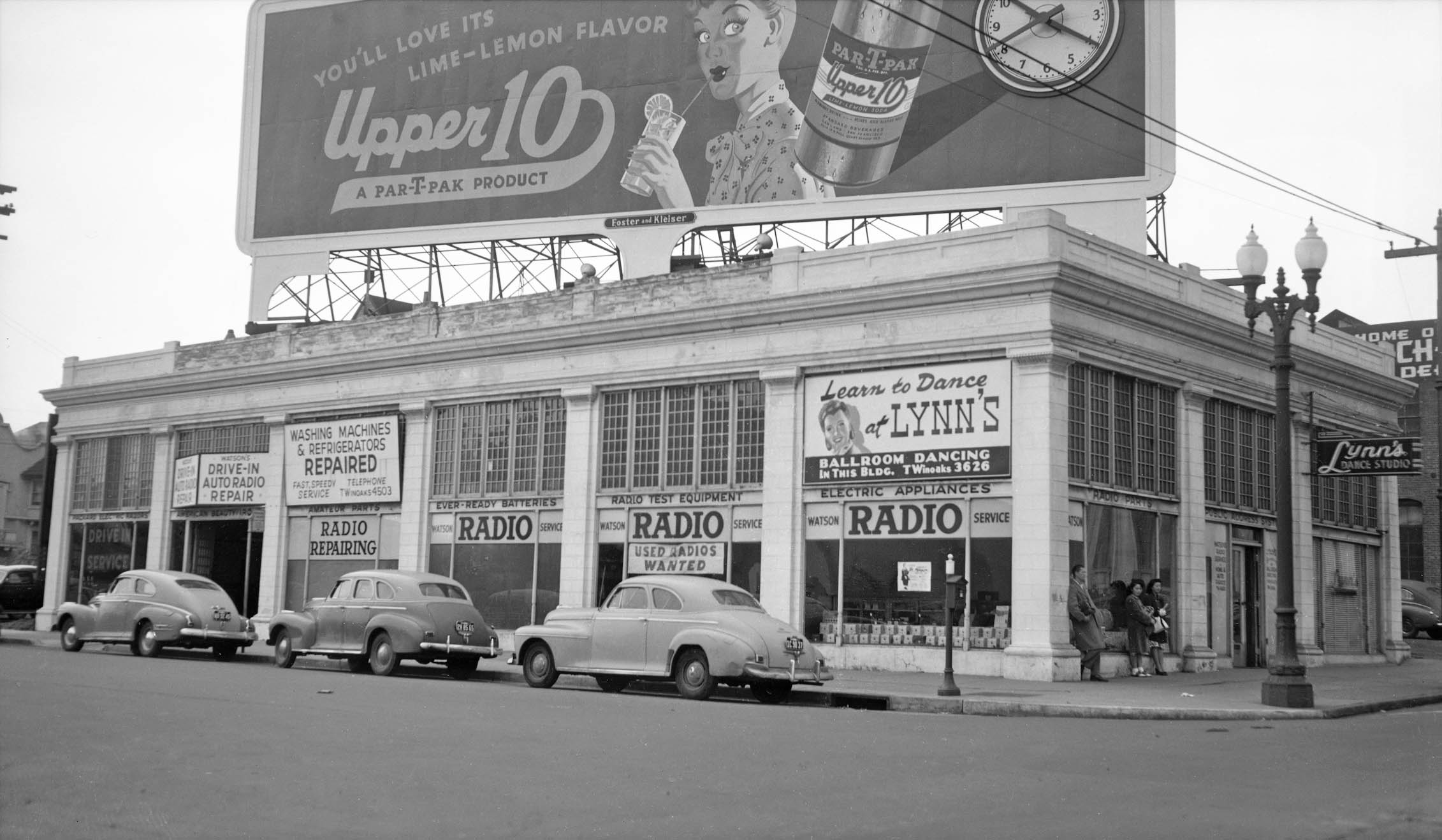
Next, an east view toward downtown, with the Alameda County Superior Courthouse dominating the skyline. It was built between 1934-1936 with funding from the Public Works Administration (PWA) and a voter-approved local bond., It has been attributed to five well known area architects; Henry A. Minton, William Corlett, James Plachek, William Schirmer, and Carl Werner. The building’s style has been labeled as Art Moderne or “PWA Moderne” or “Depression Moderne”, a later phase of Art Deco. Next to view land on either side of the courthouse where the new Viaduct will impart the biggest changes. First to the left or south, showing the billboard displaying a woman’s wide-eyed expression.
L329-85-Dept. of Public Works, City of Oakland, Courtesy BAERA, Western Railway Museum Archives, 233761ov, (Image 17 of 26)
Fallon St. between 11th and 12th St. sported such enterprises as Watson Radio fronting Fallon St., and Lynn Dance Studio entered at no. 51 12th St., southwest view. The building should look unfamiliar, as it would be razed in the 1960s to allow space for the new Oakland Museum of California. Next to the north side of the courthouse.
L329-90-Dept. of Public Works, City of Oakland, Courtesy BAERA, Western Railway Museum Archives, 233765ov, (Image 18 of 26)
The Oakland Electrical Building, or Fire Alarm Building, so named as it served until 1983 to house the alarm system for the Oakland Fire and Police Departments after the prior system was damaged in the 1906 earthquake. The architect was Walter J. Mathews, who designed Borax Smith’s residence, Oak Hall, the Key Route Pier, and replaced John J. Donovan as architect for the Oakland Civic Auditorium. Behind it is seen the Islamic Cultural Center of Northern California, no. 1433 Madison St., originally built as the Scottish Rites Cathedral in 1908-1909. Both buildings still exist in 2025.
L329-95-Dept. of Public Works, City of Oakland, Courtesy BAERA, Western Railway Museum Archives, 233771ov, (Image 19 of 26)
A west view of the Fire Alarm Building is seen here. As expected, the building is constructed from fire-proof components. As of 2019, the structure was used by city employees in various departments, and the Lake Chalet restaurant leased some of the parking. The Museum of Jazz and Art has been attempting to somehow incorporate the building into a larger music venue since 2019, but the proposed structures have not gained approval by the city.
L329-100-Dept. of Public Works, City of Oakland, Courtesy BAERA, Western Railway Museum Archives, 233772ov, (Image 20 of 26)
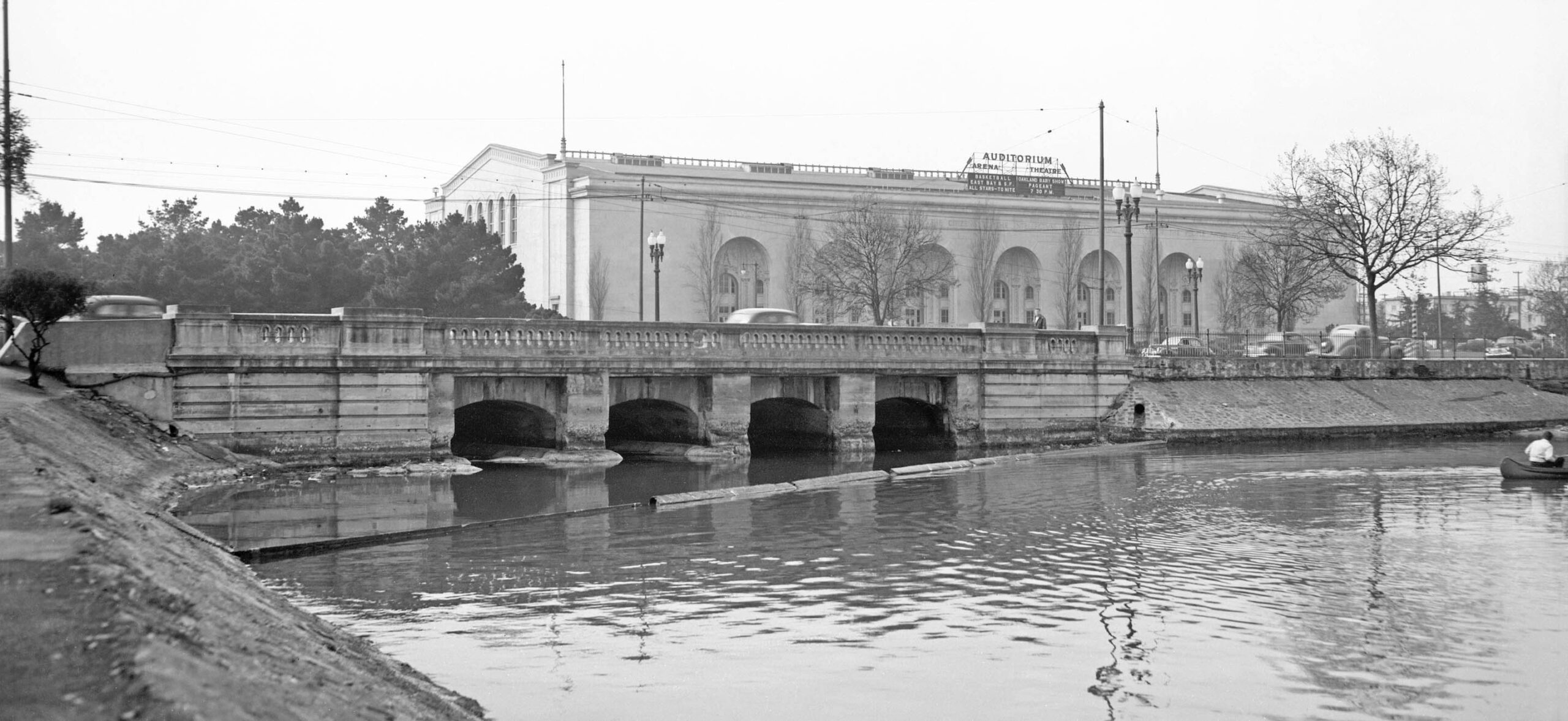
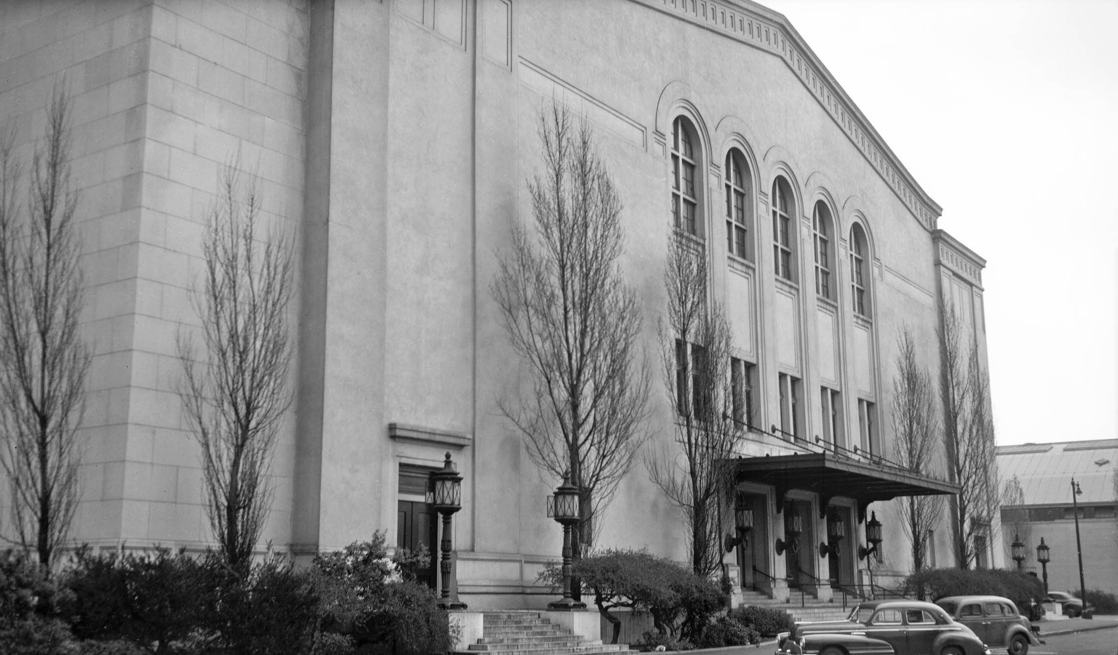
Continuing with images from Mar. 21, 1946, this east view is of the west entrance of the Oakland Civic Auditorium. The Beaux-Arts-style landmark built with a steel frame and reinforced concrete was dedicated in 1915. The architect was John J. Donovan, known best for his Oakland school designs. Financing for the construction was fueled by a $500k bond issue passed in 1912, but civic organizations expanded its functions without additional funds resulting in a financial shortfall. Donovan was replaced by Walter J. Mathews, who did not alter the design, and after a failed first attempt, a second $500k bond issue was passed in 1914, the final construction cost ending up at $978,052.
L329-105-Dept. of Public Works, City of Oakland, Courtesy BAERA, Western Railway Museum Archives, 233773ov, (Image 21 of 26)
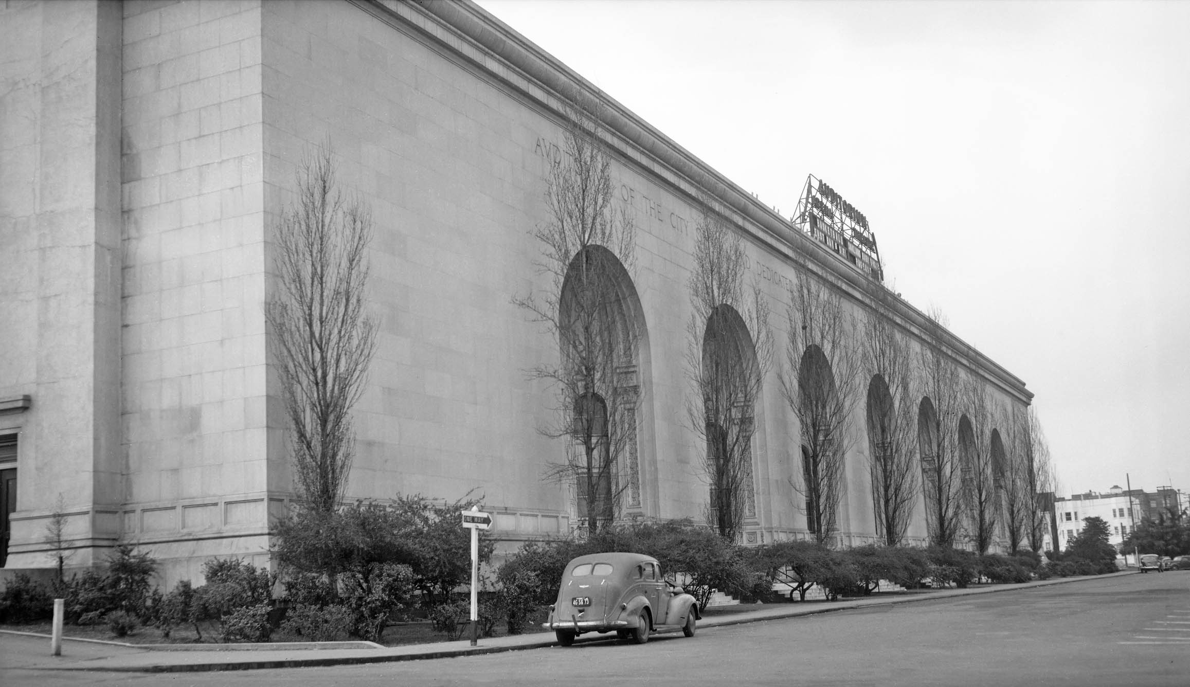
Next to west view of the north entrance of the auditorium. It was renamed in honor of Henry J. Kaiser after a 1984 renovation, and was listed on the National Register of Historic Places in 2021. Renovations began with construction started in late 2020 under a 99-year lease agreement between the City and Oakland Civic, LLC and its parent company, Orton Development. The interior was completed in 2023, housing a 25,000 sq. ft. arena, a 1500-seat theater with the Calvin Simmons Theatre as the major tenant, and three ballrooms.
L329-110-Dept. of Public Works, City of Oakland, Courtesy BAERA, Western Railway Museum Archives, 233775ov, (Image 22 of 26)
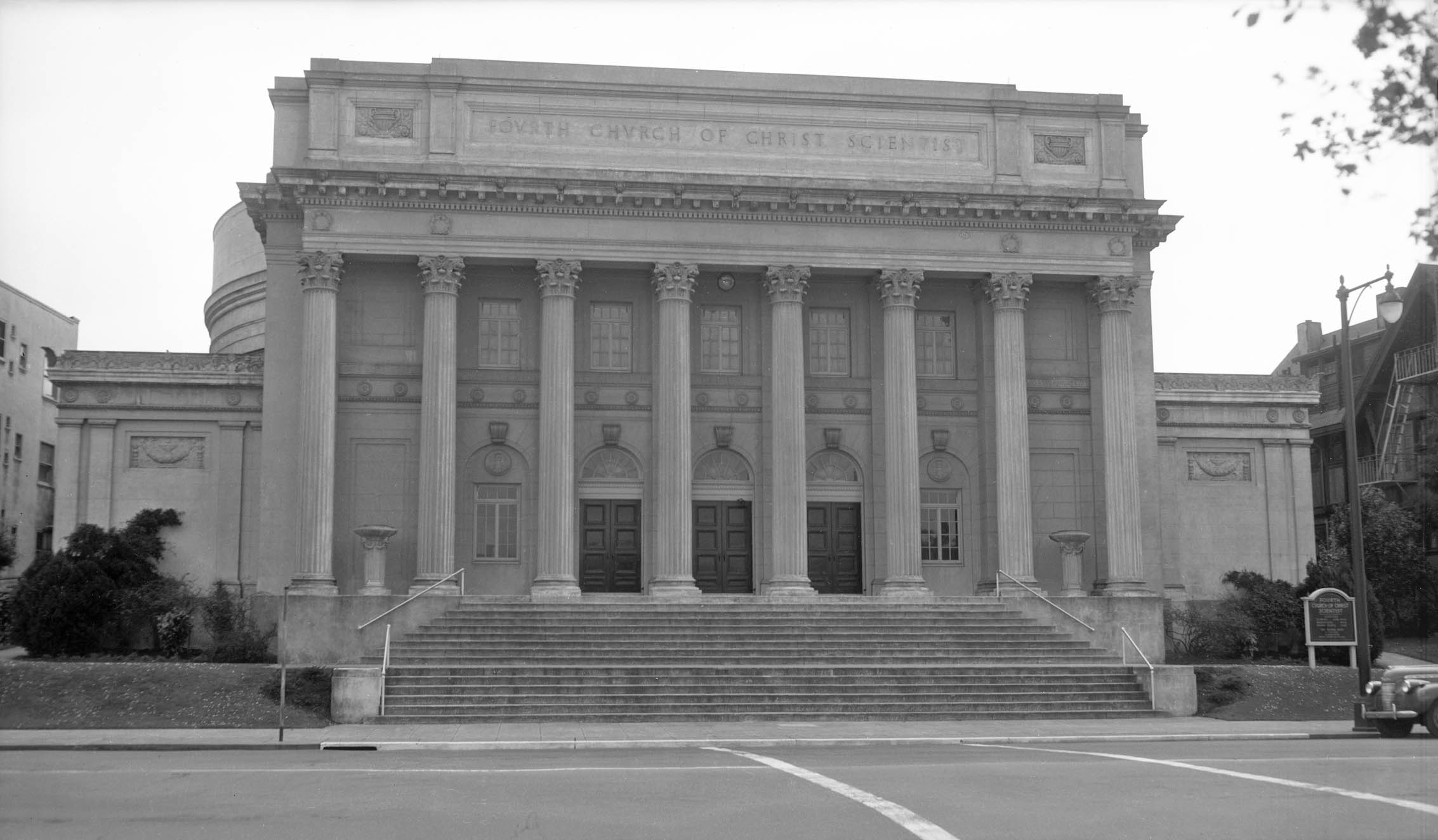
To the east of the 12th St. dam was the Fourth Church of Christ, Scientist, completed in 1923, the architect being Carl Werner. Its location was not to impact the Viaduct. By 1987, the congregation decided the building no longer suited their needs, and that rehabilitation would be too costly. In the spring of 1987, the Landmarks Advisory Board deemed the building “architecturally significant”, but would not grant landmark status, even if it compromised a possible National Register District designation surrounding Lake Merritt. It could not find a suitable buyer or tenant, and was demolished over a one week period starting Mar. 22, 1989. The Lake Merritt United Methodist Church completed its current building on this spot in 1991.
L329-115-Dept. of Public Works, City of Oakland, Courtesy BAERA, Western Railway Museum Archives, 233762ov, (Image 23 of 26)
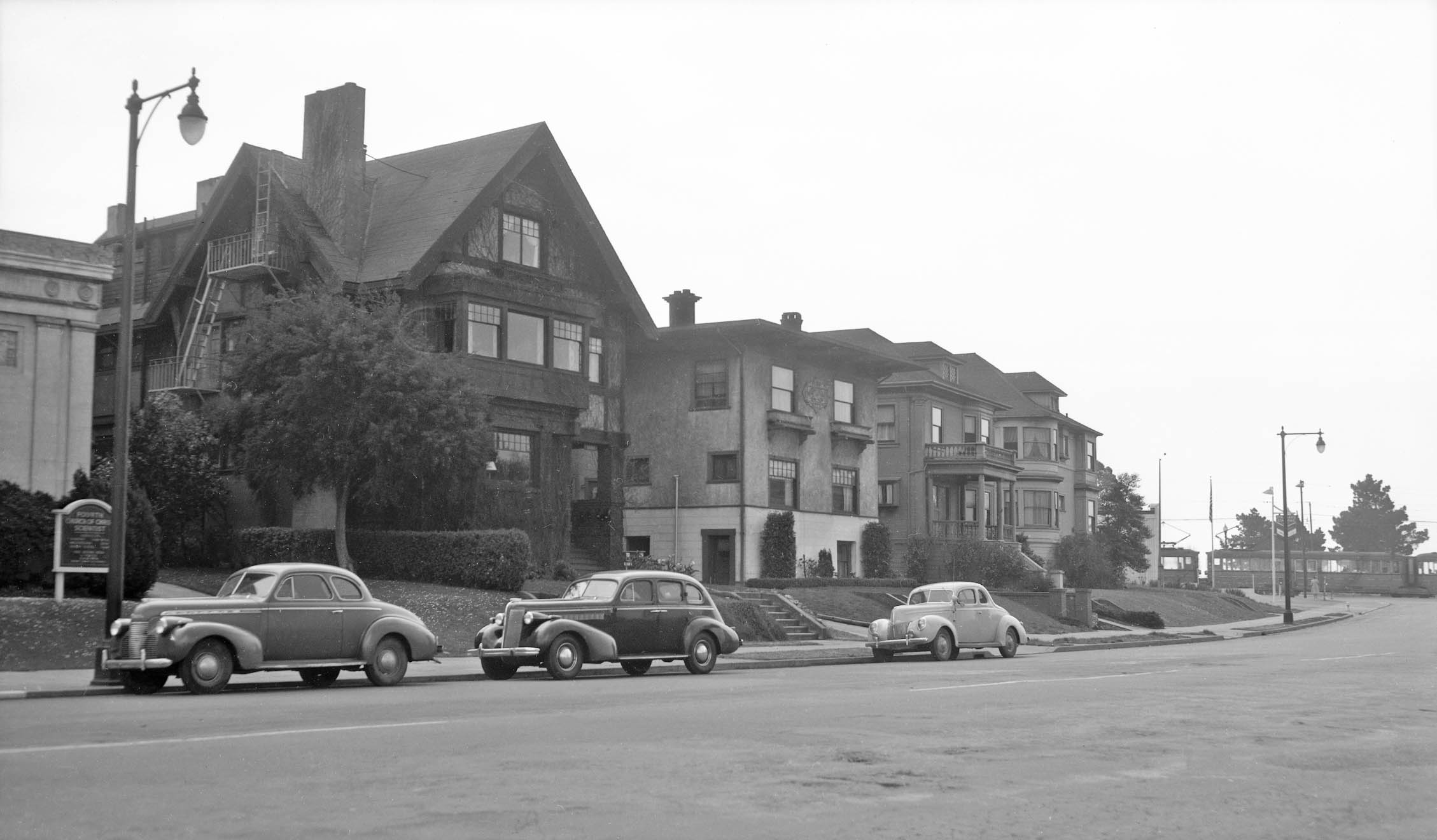
To the southwest of the church were four residences, nos. 1222-1318 Lakeshore Ave., seen here in a southwest view from Mar. 21, 1946. These houses were built between 1905-1912, and would be razed in the early 1960s to allow the luxury apartment building, 1200 Lakeshore, to be constructed between 1964 and 1967. Note the Key interurban train about to enter the 12th St. Dam from 1st Ave.
L329-120-Dept. of Public Works, City of Oakland, Courtesy BAERA, Western Railway Museum Archives, 233766ov, (Image 24 of 26)
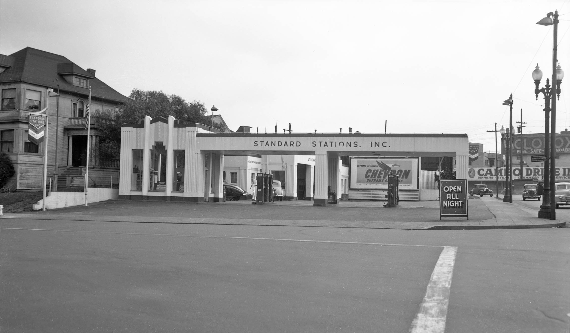
The Standard Gas Station, the one mentioned previously that replaced the corner house at Lakeshore Ave. and 1st Ave., would suffer an even worse fate, and would be razed for the Viaduct construction. South view, Mar., 21 1946.
L329-125-Dept. of Public Works, City of Oakland, Courtesy BAERA, Western Railway Museum Archives, 233778ov, (Image 25 of 26)
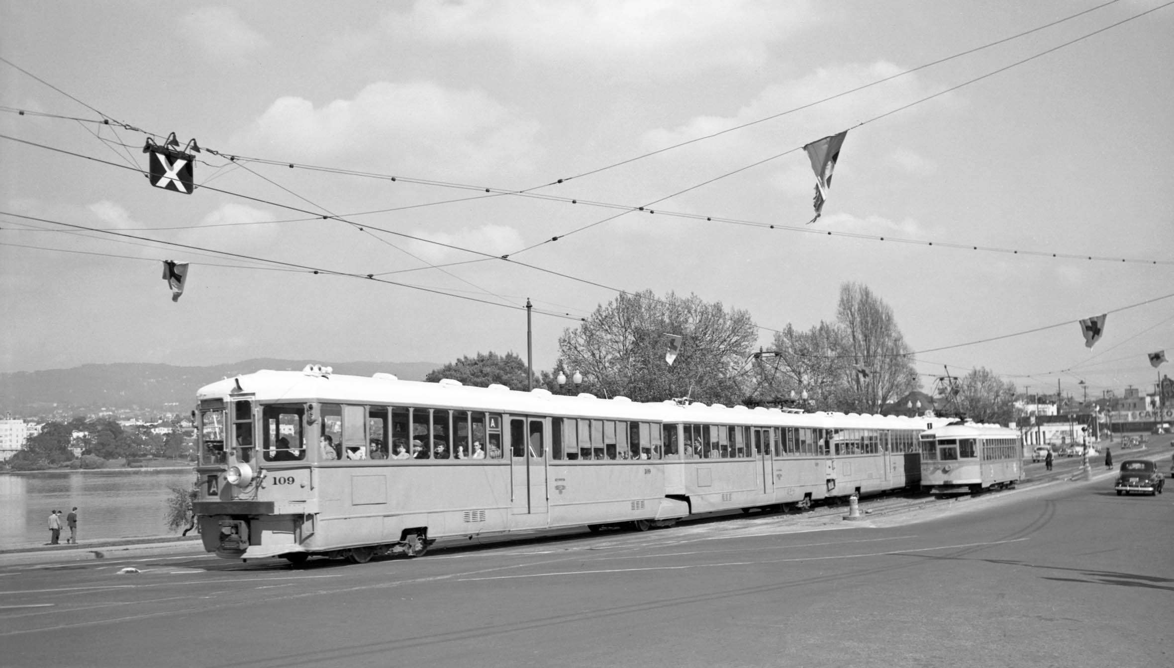
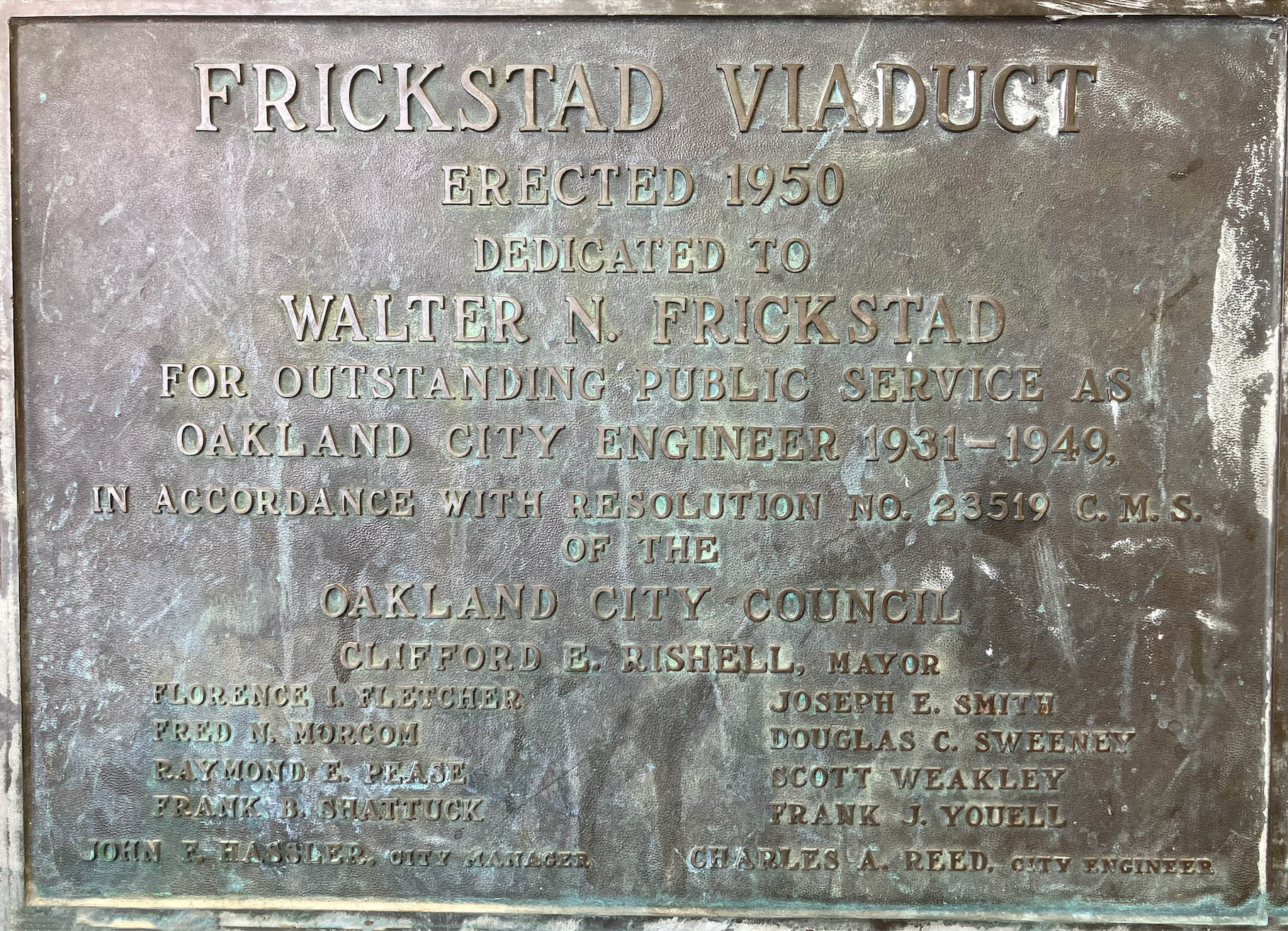
Taking houses and other properties by eminent domain to build the Viaduct would be the least of the planners obstacles. This east view shows KS 109 as A line interurban consisting of two Key units heading westbound on the 12th St. dam at Fallon St. passing KS 925 as a Line 1 streetcar heading to 14th St. in Mar. 1948. By the end of that Nov., all Key streetcar lines would have been abandoned, the car house shuttered to be razed. The A line interurban would continue to use the 12th St. dam, but the issues it caused for a new road configuration will be one of the subjects of the next update. Appreciation to Betty Marvin for the preservation and donation of the images and plaque.
L329-130-Arthur Lloyd Photo, Courtesy BAERA, Western Railway Museum Archives, 111993ks, (Image 26 of 26)