The Live Oak-Peachton Branch and the Gentle Curve
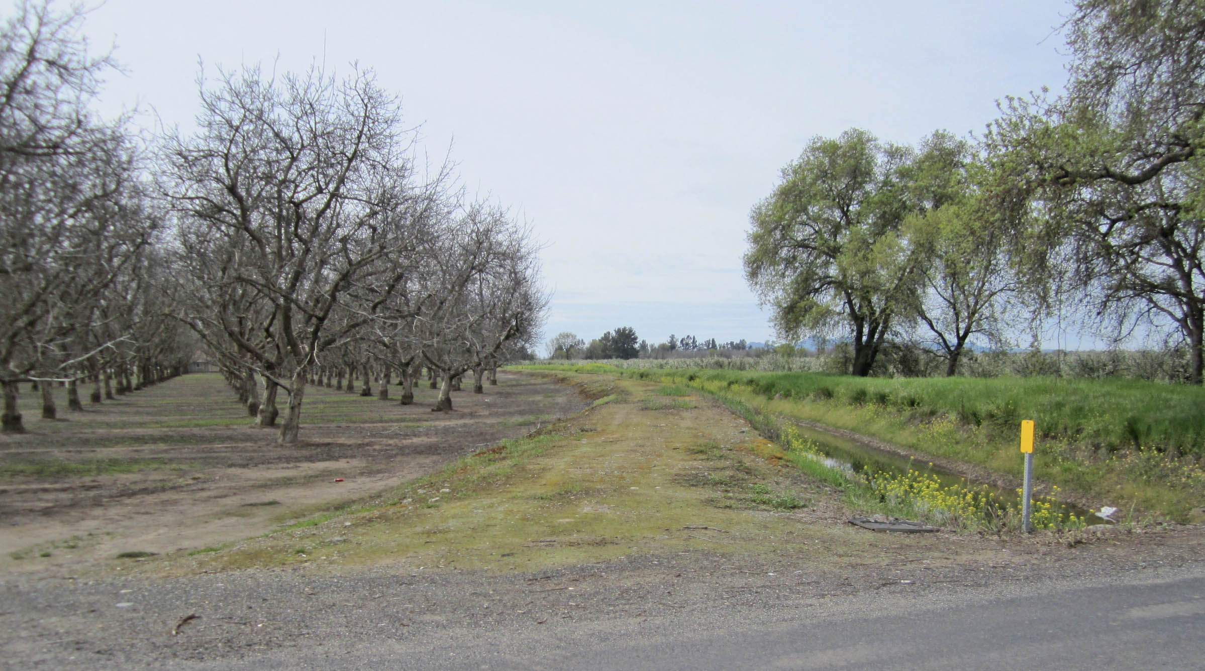
The gentle curve of the Sacramento Northern Railway, SN, right-of-way at Peachton, formerly Ord Rancho, is seen in a southwest view from Ord Rancho Rd. in 2018. Although taken as an “after” image to a similar view taken more than one hundred years before, those walnut trees to the left or east of the abandoned right-of-way were not there at the earlier date and are absent in 2025 as well.
L324-05-Stuart Swiedler Photo, (Image 1 of 34)

Recall that the creation of the Oroville Dam Afterbay resulted in the SN diverting its mainline between Durham and Live Oak to Southern Pacific, SP, rails on Feb. 1, 1967, creating two branch lines serving Durham to Oroville Jct., turquoise line, and Live Oak to Peachton, orange line, respectively. This update will examine the Live Oak-Peachton Branch, officially abandoned on Nov. 12, 1971.
L324-10-Courtesy BAERA, Western Railway Museum Archives, 39641 l, Google Maps, r, (Image 2 of 34)
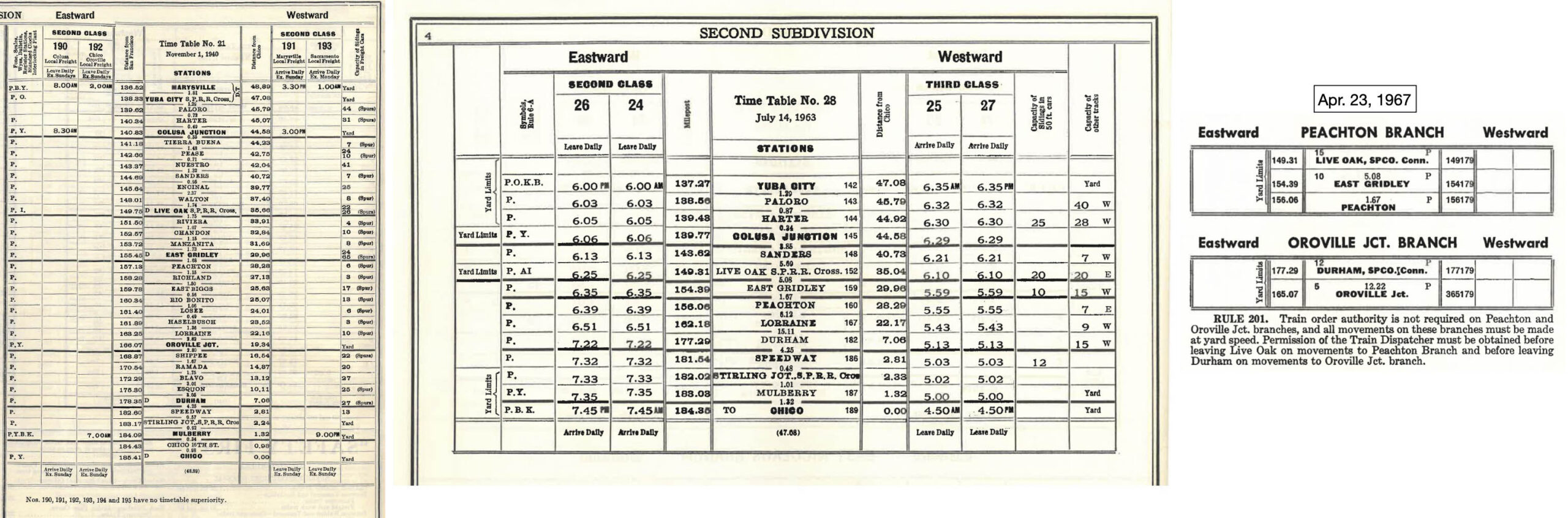
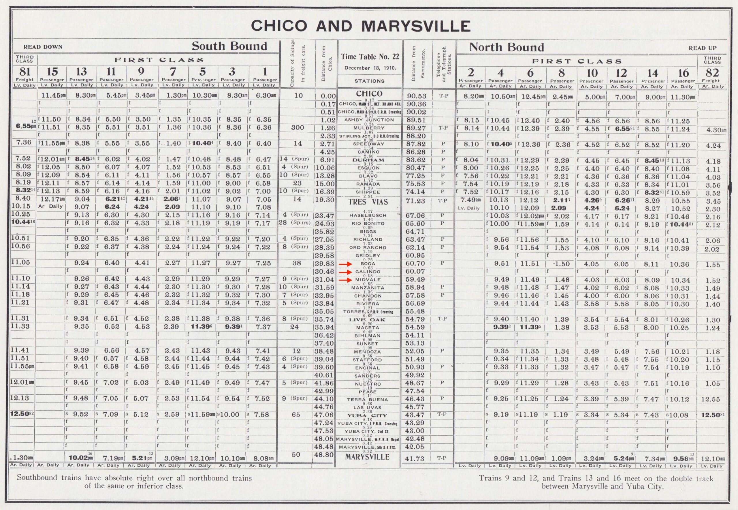
The employee timetable from 1940, left, provides the stations between Live Oak and Peachton that will be the center of attention on this update. Three minor stops between Manzanita and East Gridley omitted here will be taken up in time. The timetables from 1963, center, and 1967, right, reveal how this section basically became a two-stop freight spur as it neared its end.
L324-15-Courtesy BAERA, Western Railway Museum Archives, 13477, l, 13489 c, 13490, r FINAL, (Image 3 of 34)
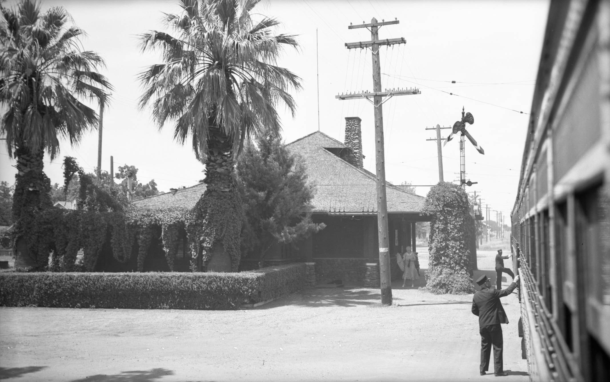
Our train for this journey is ready to depart from the station at Live Oak, north view from 1940.
L324-17-Howard T. Wolfe Photo, Courtesy BAERA, Western Railway Museum Archives, 232734sn, (Image 4 of 34)
This north view from Mar. 7, 1958 shows the wall-to-wall agricultural terrain to be tackled beyond the SP crossing, green arrow. After a gentle turn to the north, the tracks ran straight as an arrow until the gentle curve at Peachton, red arrow.
L324-20-Copyright California Department of Transportation, 5884-2, (Image 5 of 34)
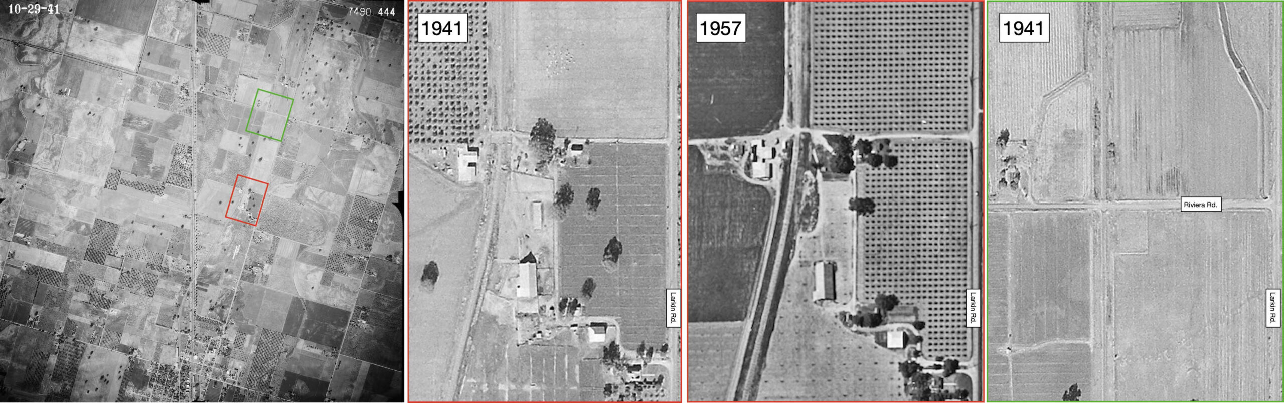
Riviera is the first and only stop on this trip in Sutter County before entering Butte County. The timetable from 1940 shown previously indicates a small freight spur capable of handling four cars. The aerial from 1941, left, indicates two possible candidates, the area boxed in red detailed in the center from 1941 and 1957, or that boxed in green, right, over the present Riviera Rd. Maybe there is a spur in the central panels, or maybe not. More research needed here to find an image showing the spur.
L324-25-c-7490_422, and cas-1957, Courtesy of UCSB Library Geospatial Collection, (Image 6 of 34)
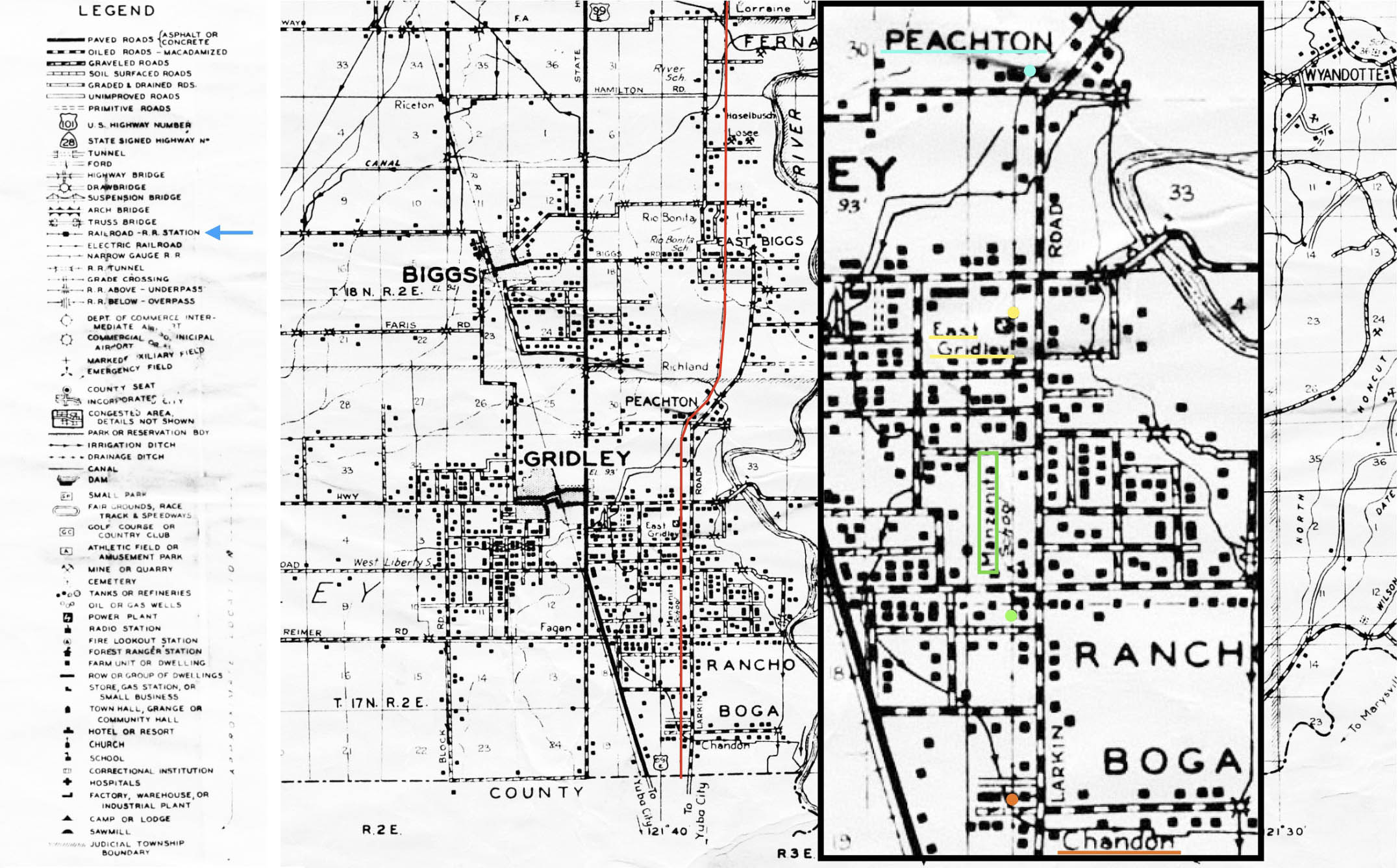
The map of Butte County from 1946, left, is detailed on the right indicating the major stops and the approximate locations of station shelters indicated by the color-coordinated dots. Again, the minor stops between Manzanita and East Gridley are also omitted here, however, the 1947 timetable not shown here gives no indication of their existence by this time. Ref: Map of Butte County, California. Compiled and published by Thomas Bros., copyright by Harry Freese. 1946. Chico Digital. G4363 B8 1946 T6, ca_2044
L324-30-Courtesy Meriam Library, California State University, Chico, ca_2044, (Image 7 of 34)
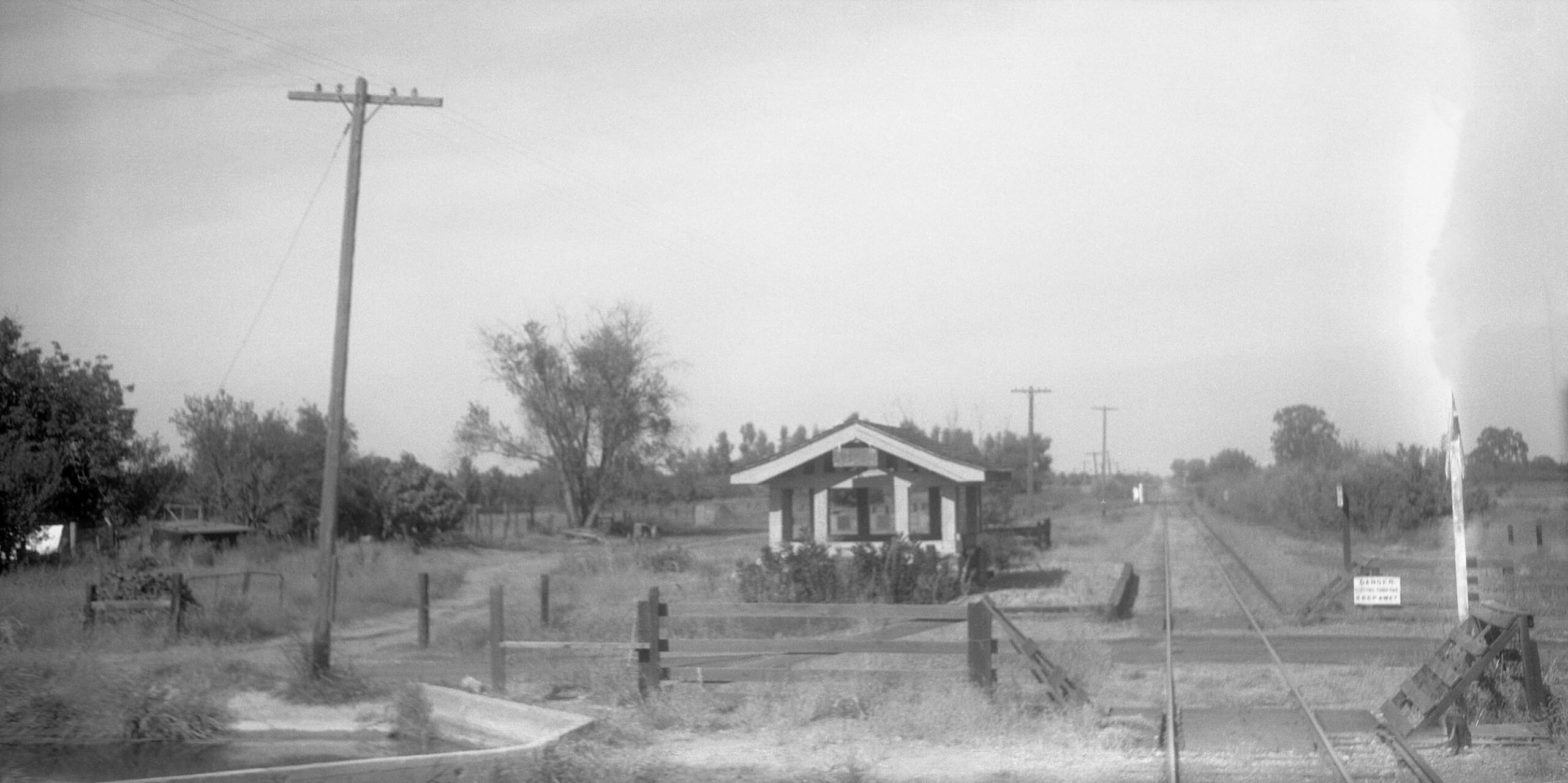
The next stop is Chandon, shown in this north view from 1940. Note the shelter with its worn-out sign, and the send off for the spur seen in the background. Most importantly, note the concrete lining of Morrison Slough seen in the lower left corner.
L324-35-Howard T. Wolfe Photo, Courtesy BAERA, Western Railway Museum Archives, 235198sn, (Image 8 of 34)
A complementary view to the south from early in the Northern Electric Railway, NE, era is shown here to detail the short spur.
L324-40-Courtesy BAERA, Western Railway Museum Archives, 236000sn, (Image 9 of 34)
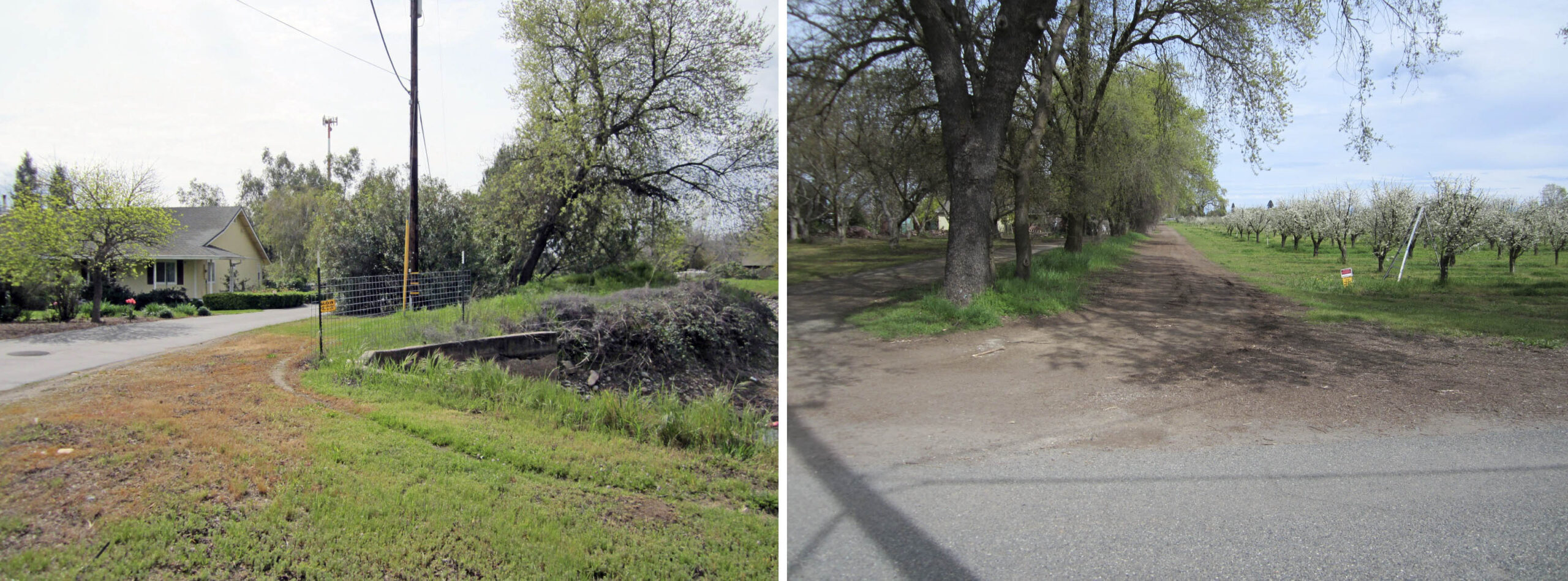
The southeast view from 2018 on the left features the concrete lining of the slough. The right-of-way has since been converted to Ruthann Way. As seen on the north view on the right, the road shifts to the west or left, and the former track roadbed continues as a entry to the orchard.
L324-45-Stuart Swiedler Photos, (Image 10 of 34)
All of the features of the area in 1941 and 2025 are covered in this multi-panel array, the presence of the shelter at Chandon indicated by the yellow arrow.
L324-50-c-7490_443, l, aax-1952_6k-205, c, Courtesy of UCSB Library Geospatial Collection, Courtesy Google Maps, r, (Image 11 of 34)
Heading further north to Turner Ave. in 2018, the east view shows abandoned track embedded in the asphalt, left. The north view in the center shows the right-of-way replaced by an orchard, the south view, right, now a grassy field.
L324-55-Stuart Swiedler Photos, (Image 12 of 34)
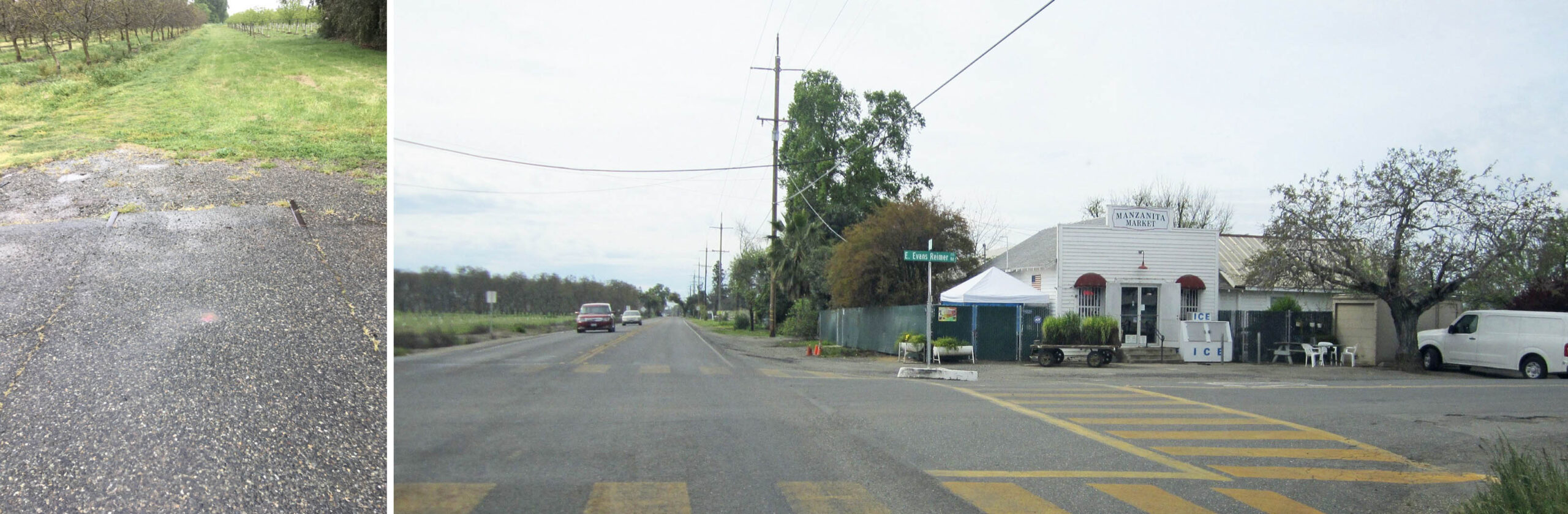
Also in 2018, one block up at Higgins Ave., left, a north view showing more remaining rail. Next stop, E. Evans Reimer Rd., a south view from Larkin Rd. showing the Manzanita Market, right. A right turn up the road will bring the tour to the Manzanita Station area.
L324-60-Stuart Swiedler Photos, (Image 13 of 34)
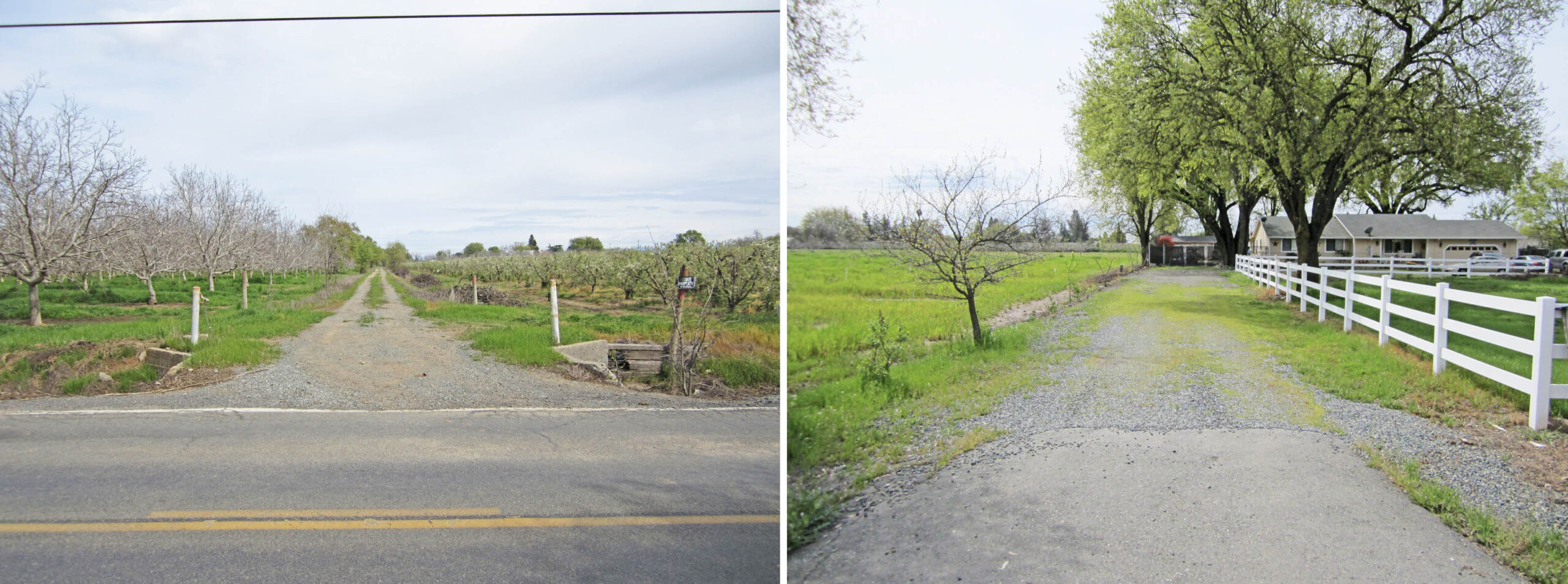
Positioned at the location of SN track, a north view from 2018 shows a path wide enough for one track, left, but the south view shows a broader driveway. No track remains have been unearthed at this location as of 2025.
L324-65-Stuart Swiedler Photos, (Image 14 of 34)
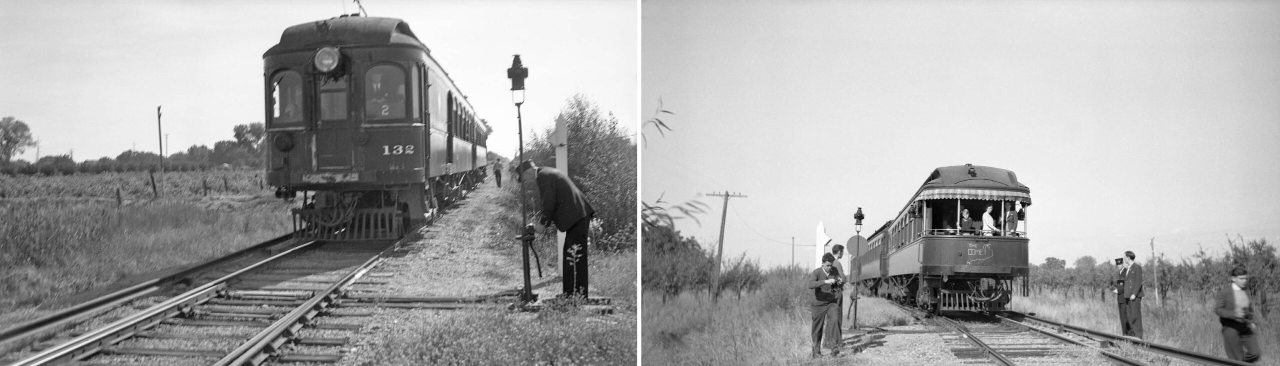
Back to a train ride in Sept. 1940 with SN 132 leading train no. 3, the train has pulled up to a switch stand between the Higgins Ave. and E. Evan Reimer Rd. crossings, left. The conductor is in the process of moving the switch to direct the train off the mainline, south view. On the right, a north view showing “The Comet” with the SN Bidwell on the rear moving on to the siding at Manzanita in Oct. 1940. This was the only place on the future branch line where images of trains were taken, for reasons that will be explained next.
L324-70-Sappers Collection, Courtesy BAERA, Western Railway Museum Archives, 137219sn, (Image 15 of 34)
A view of another train from Sept. 1940 led by SN 127 with SN 223 on the siding inching toward the end of the third rail and clear of the mainline. Before the end of 1928 merger, employee timetables all noted that trains heading southbound had priority over those heading north, the latter waiting on a siding or “waiting in the hole”. After 1928, specific instructions were given depending on the train in question. There are many images of trains in the hole at Manzanita in 1940, but it was not designated as a waiting point in the 1940 timetable.
L324-75-Sappers Collection, Courtesy BAERA, Western Railway Museum Archives, 137218sn, (Image 16 of 34)
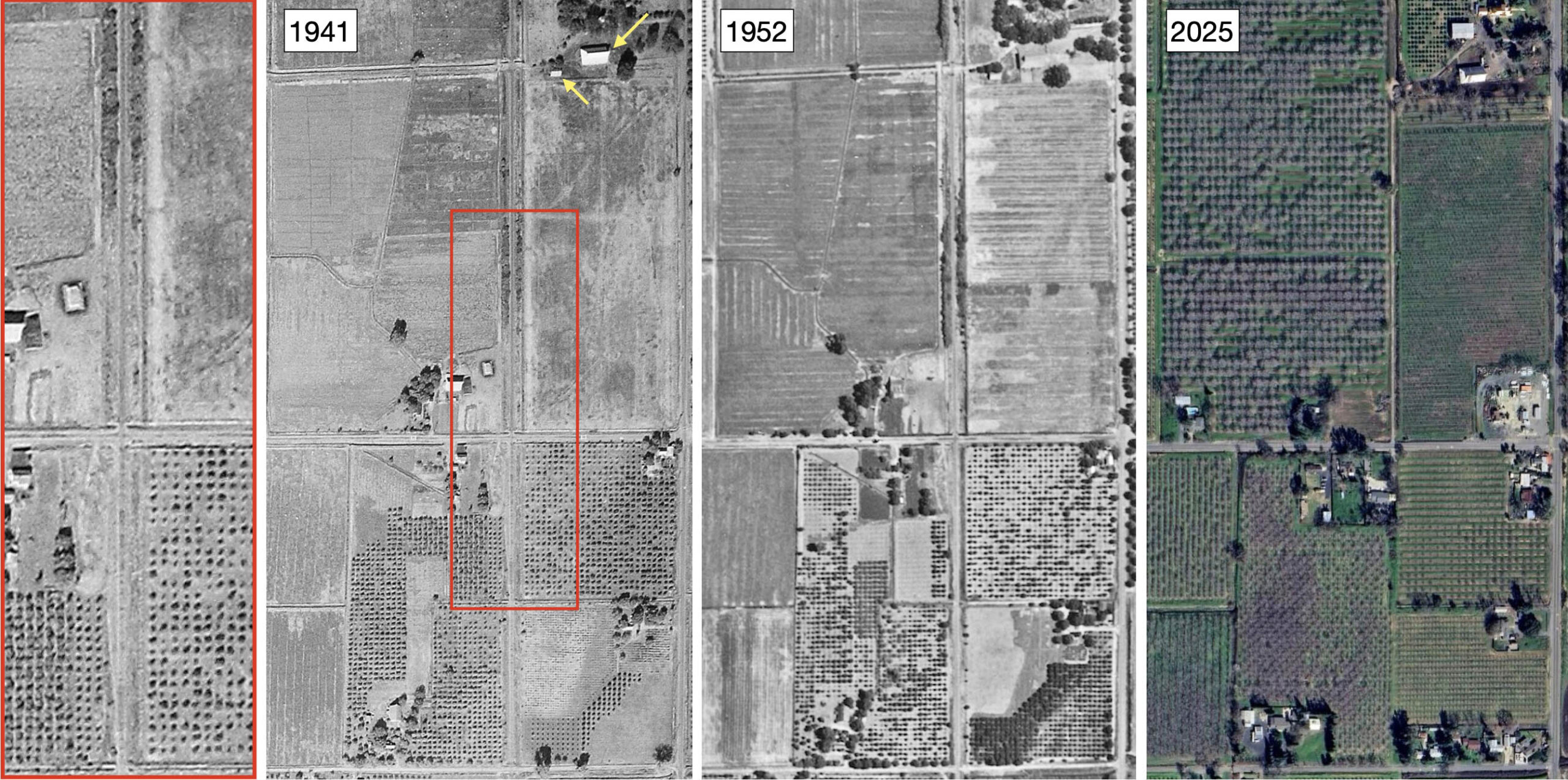
This three aerials show the intersection of the SN right-of-way with E. Evans Reimer Rd. The crossing is detailed to the left of the 1941 aerial, red outline. The widening of the track south of the crossing matches the ground image, but by 1941 it appears the little shelter at the southwest corner appears to have already been removed. If the spotting of this location is not totally convincing, note the two yellow arrows pointing to structures that will be seen in the next image.
L324-80-c-7490_442, l, aax-1952_6k-205, c, Courtesy of UCSB Library Geospatial Collection, Courtesy Google Maps, r, (Image 17 of 34)
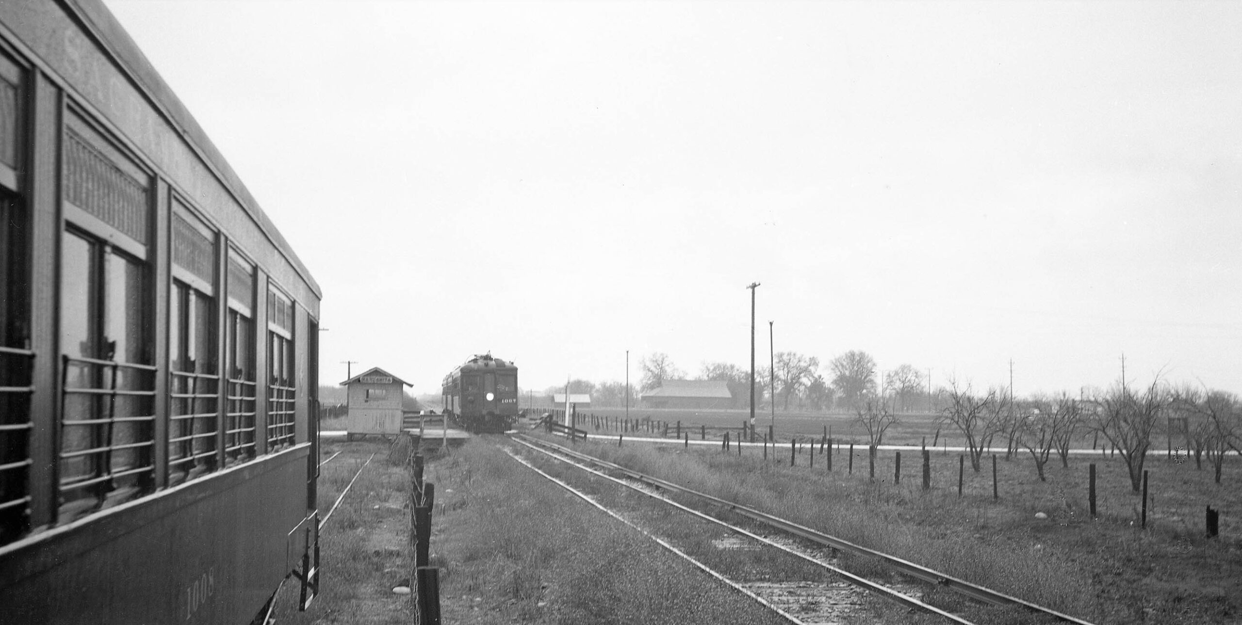
In an image that speaks for itself, southbound SN 1007 as train no. 7 passes SN 1008 as train no. 2 in the hole in Sept. of 1940. The two buildings marked by the yellow arrows in the previous aerial are clearly seen in the background on the left or east.
L324-85- Sappers Collection Courtesy BAERA, Western Railway Museum Archives, 137213sn, (Image 18 of 34)
Further north, the 1910 Northern Electric Railway, NE, Employee Timetable no. 22 notes three closely spaced stops between Manzanita and Gridley, red arrows. Not shown here, the timetable of 1914 shows Boga and Gridley now as one “East Gridley”, Galindo is absent, but still shows on the map, while Midvale with a spur handing 10 cars is still on the timetable and map. By 1924, Midvale and Galindo appear only on the map. Just prior to the merger, only Galindo appears on the map, and will remain so until after WWII.
L324-90-Courtesy BAERA, Western Railway Museum Archives, (Image 19 of 34)
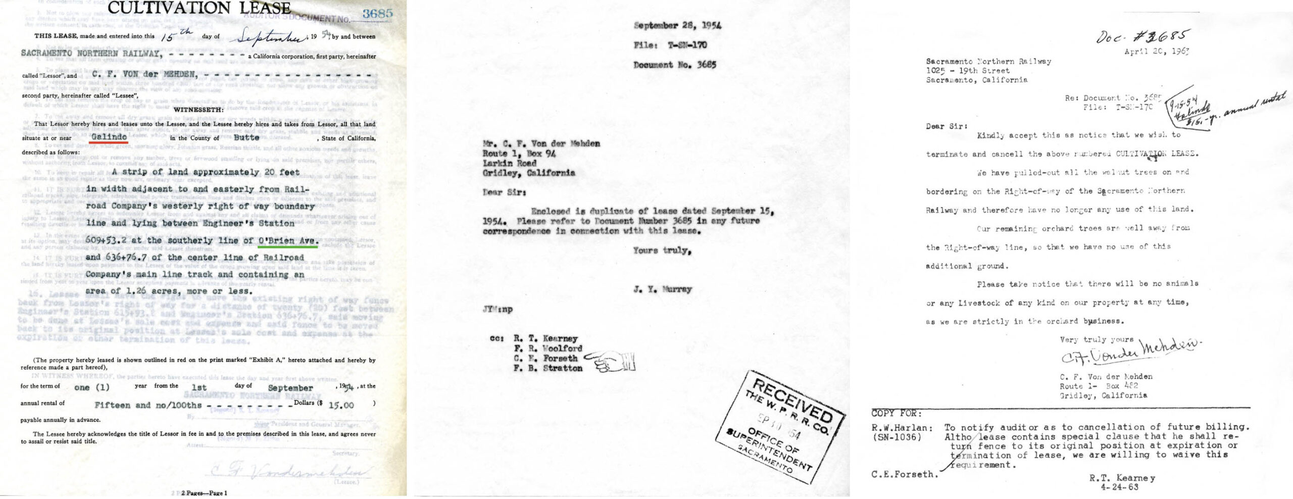
However, the cultivation lease from 1954 still designates the area as Galindo, red underline, and associates it with O’Brien Ave., green underline, left. The center document confirms the lease on Sept. 28, 1954, while the termination of the lease in 1963 can be viewed in the document on the right. The distance listed between Manzanita and Galindo make sense that the latter was at O’Brien Ave.
L324-95-Courtesy BAERA, Western Railway Museum Archives, 39592, (Image 20 of 34)
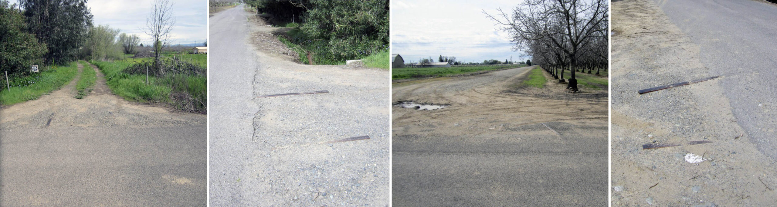
A visit to the former crossing of O’Brien Ave. in 2018 reveals many remains of track to the north, left and left center, and south, right center and right. The far right panel, a west view on the south side, shows the tracks not being parallel, possibly part of a switch track. A look on Google Maps in 2025 shows another set of tracks have appeared, a reminder next time to bring a broom.
L324-100-Stuart Swiedler Photos, (Image 21 of 34)
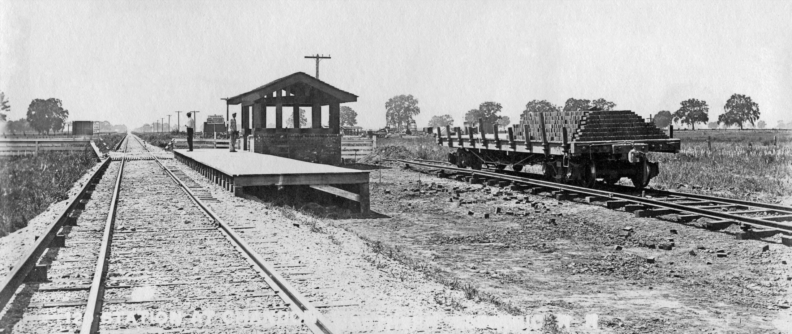
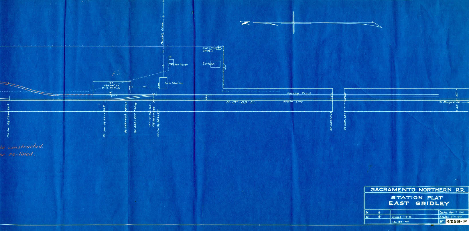
Next to the SN’s biggest freight customer on the the branch, East Gridley. This station diagram revised to Nov. 6, 1923 shows the southern-most portion containing the electrical substation.
L324-105-Courtesy BAERA, Western Railway Museum Archives, 132045sn, (Image 22 of 34)
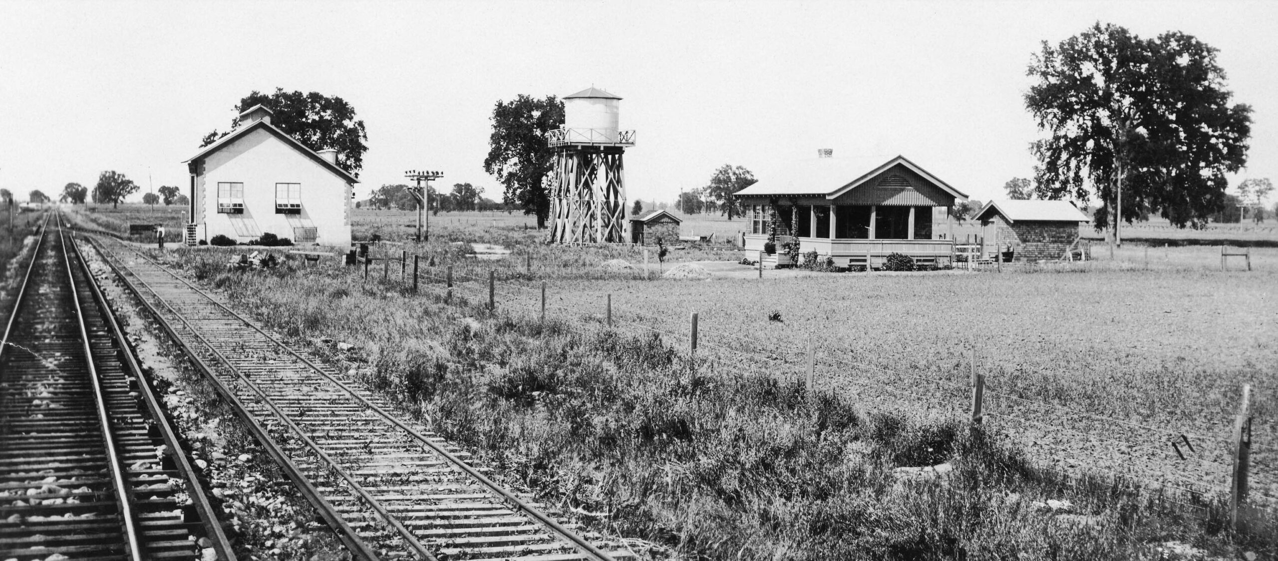
This early NE photo was labeled Boga, indicating the original name of the portion that later became part of the expanding East Gridley operation. The substation, water tower and cottage that marked this spot can be appreciated in this north view, the former surviving as an abandoned shell into at least the late 1950s.
L324-110-NE Photo, Courtesy BAERA, Western Railway Museum Archives, 209045sn, (Image 23 of 34)
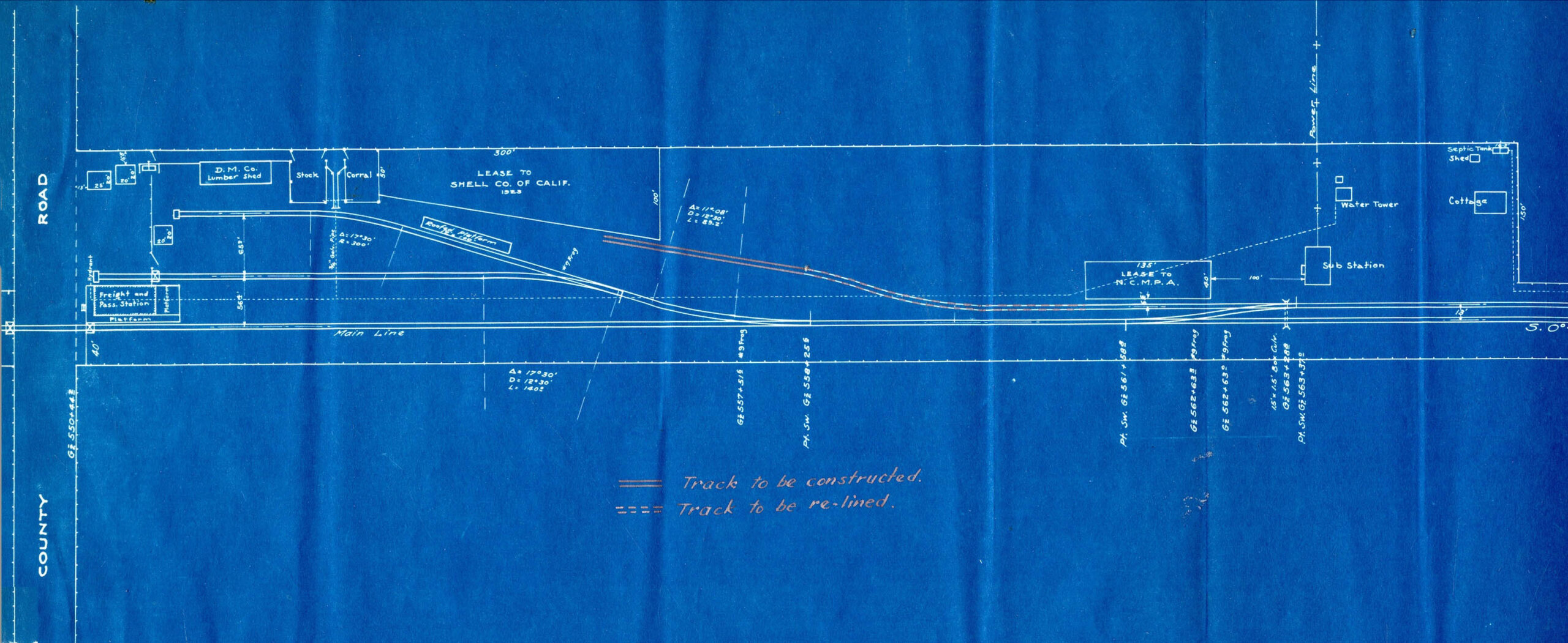
Further to the north as of Nov. 6, 1923, the freight operation featured Shell Oil and Diamond Match Lumber, and the freight and passenger station at the road intersection later to be named East Gridley Rd.
L324-115-Courtesy BAERA, Western Railway Museum Archives, 132044sn, (Image 24 of 34)
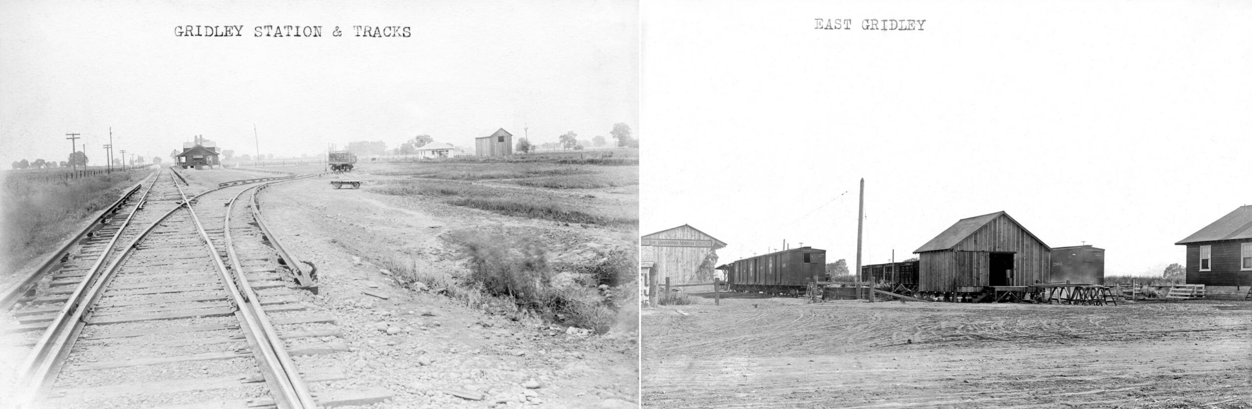
An early image viewed to the north from the NE era on the left shows the switch to the industrial sidings, and the station to the north on the right or east of the mainline. On the right, a little later in time showing the Diamond Match Co. warehouse. Documents shown in a previous update from the late 1950s testify to the SN and Western Pacific’s, WP, determination to retain this freight operation once the SN mainline was shifted to the SP mainline.
L324-120-Sappers Coll. 132034sn, l, American Photo Co, 240230sn, r, Courtesy BAERA, Western Railway Museum Archives, (Image 25 of 34)
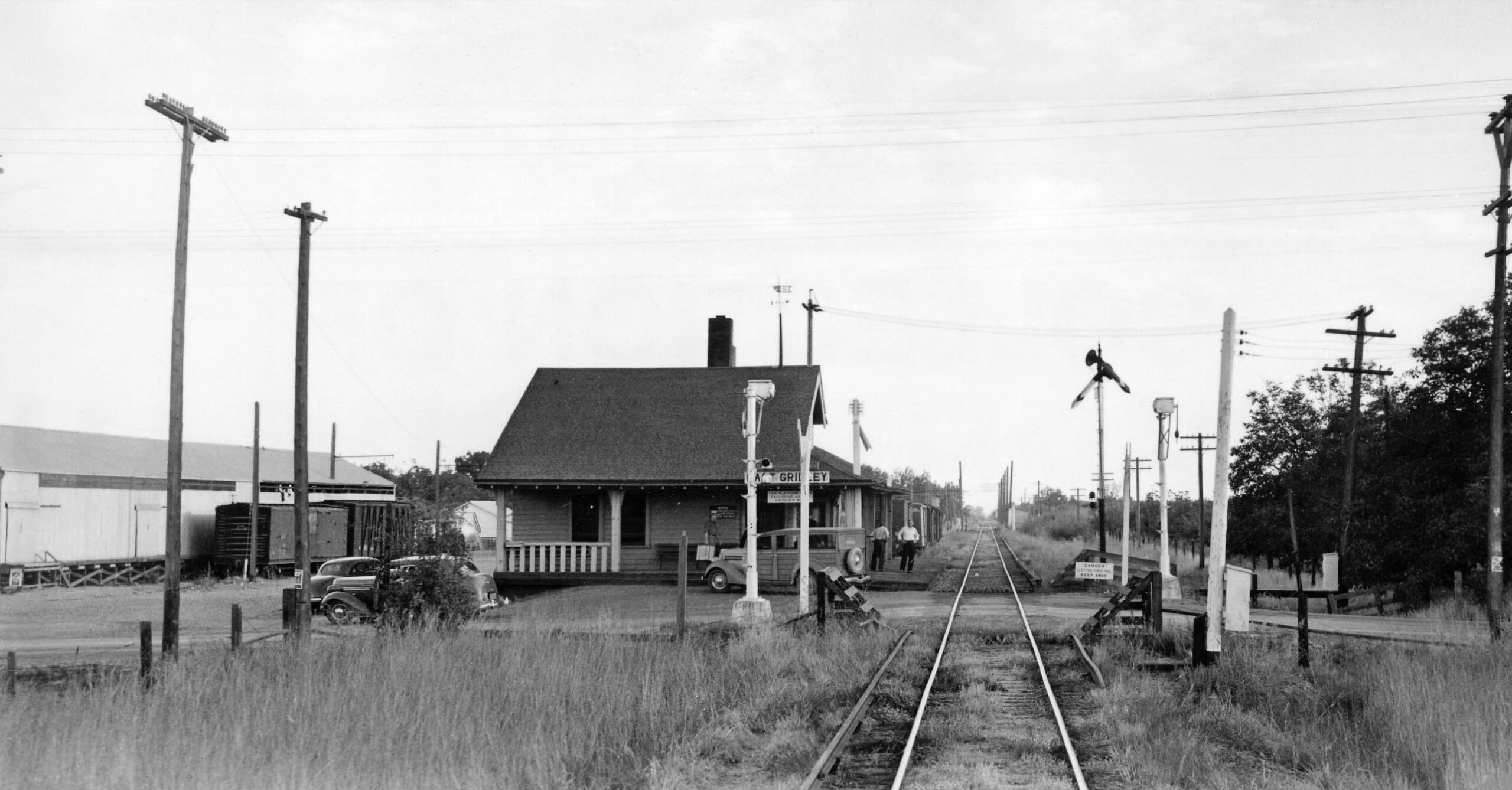
Finally, a south view of the passenger and freight station as seen from East Gridley Rd. on Sept. 9, 1939. The bus taking passengers west to Gridley waits along the station. Note in the distance the row of poles on the right or west of the track, duplicated in only one other place on the SN on the Colusa Branch based on other evidence.
L324-125- Ralph Melching Photo, Wurm Collection, Courtesy BAERA, Western Railway Museum Archives, 104243sn, (Image 26 of 34)
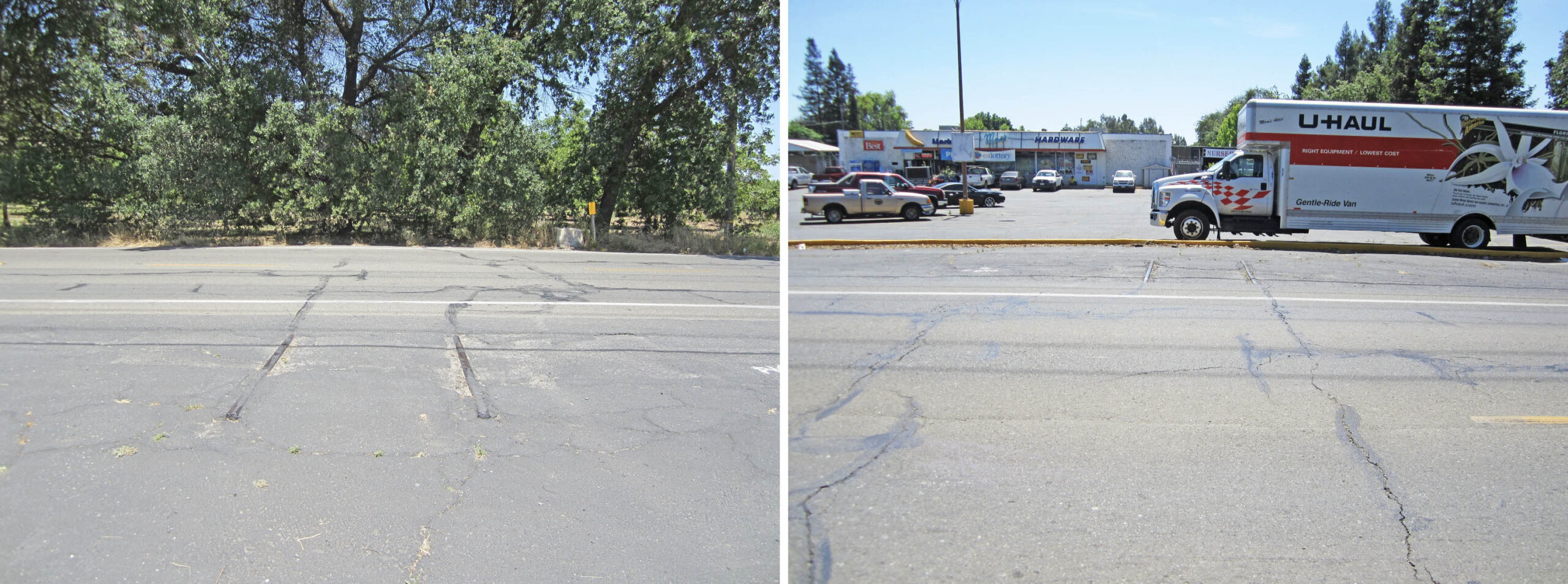
Back in 2018, the road still had track, here facing north on the left, and south on the right. The image serves only one purpose in 2025, that is to allow lining up the track position in aerial views. Note in the left image, the concrete base that once supported a wig-wag signal, to the left of the yellow marker. Unfortunately, the road has been redone since these photos were taken, so in 2025 the tracks and base have been removed.
L324-130-Stuart Swiedler Photos, (Image 27 of 34)
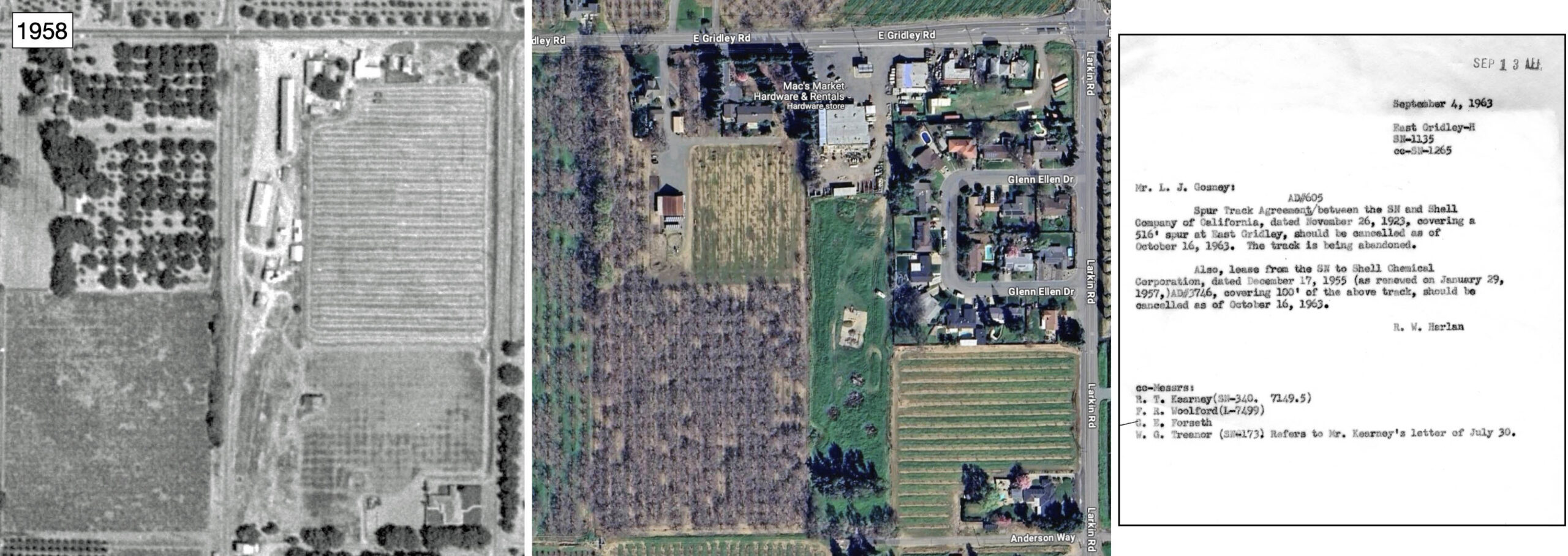
Shown previously, the WP Circular No. 167-E ca. 1957 listed East Gridley with a team track capable of handling 10 cars, and two remaining customers, Shell Oil Co. and Sutter Orchard Supply Co. The aerial from 1958 shows the freight operation, and the abandoned substation along the lower margin. On the right, the document showing the termination from Shell Oil for their lease dated Sept. 4, 1963 is presented. Ref: Left, Aerial Collection, Archives and Special Collections, UC Davis Library G4363.B8A4 1958.U8; Center, Courtesy Google Maps; Right, Courtesy BAERA, Western Railway Museum Archives, 39592
L324-135-Multiple Attributions, (Image 28 of 34)
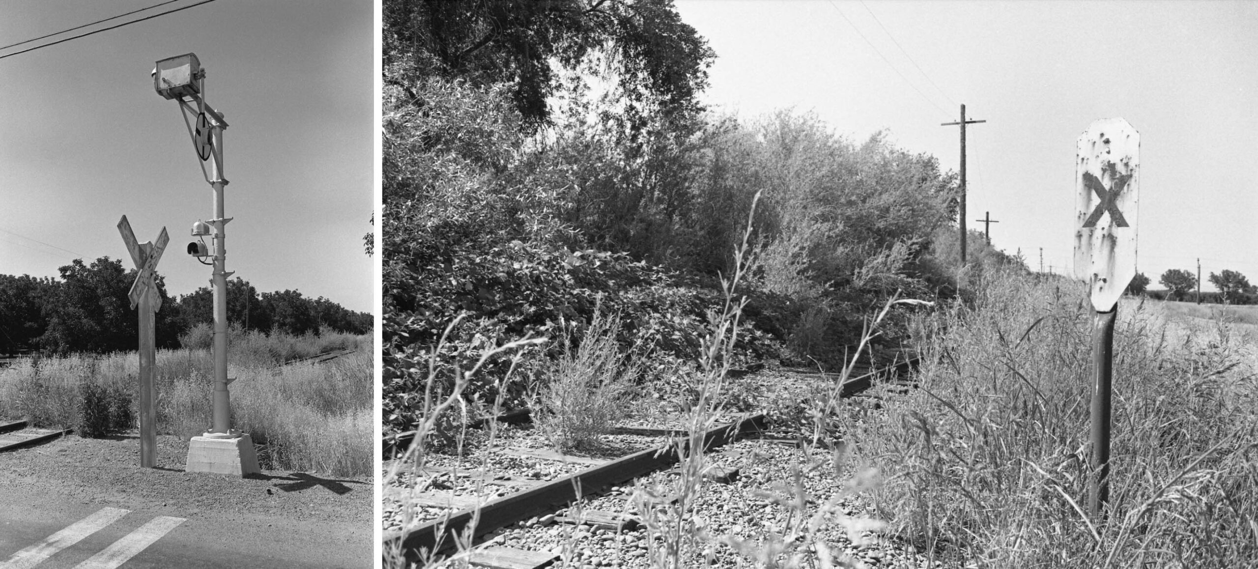
Photojournalist Ted Benson visited East Gridley on June 20, 1971, one week shy of five months prior to the official abandonment. This north view south of East Gridley Rd. in what would have been the area serving industrial customers shows dual track that had not been used for quite a while. Note the extended ties that had once supported the third rail.
L324-140-Ted Benson Photo, Courtesy Ted Benson, (Image 29 of 34)
The north side of the road crossing is seen on the left, northwest view from June 20, 1971. The wig-wag signal is still in place, the stand of which survived until very recently. Further north where the line was single track, right panel, the overgrowth of vegetation is even more pronounced.
L324-145-Ted Benson Photos, Courtesy Ted Benson, (Image 30 of 34)
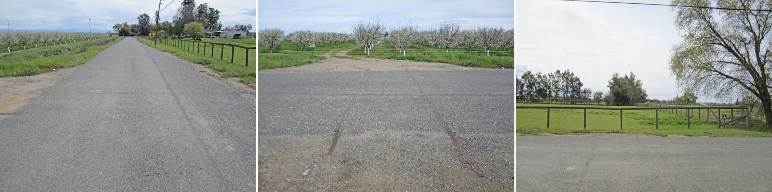
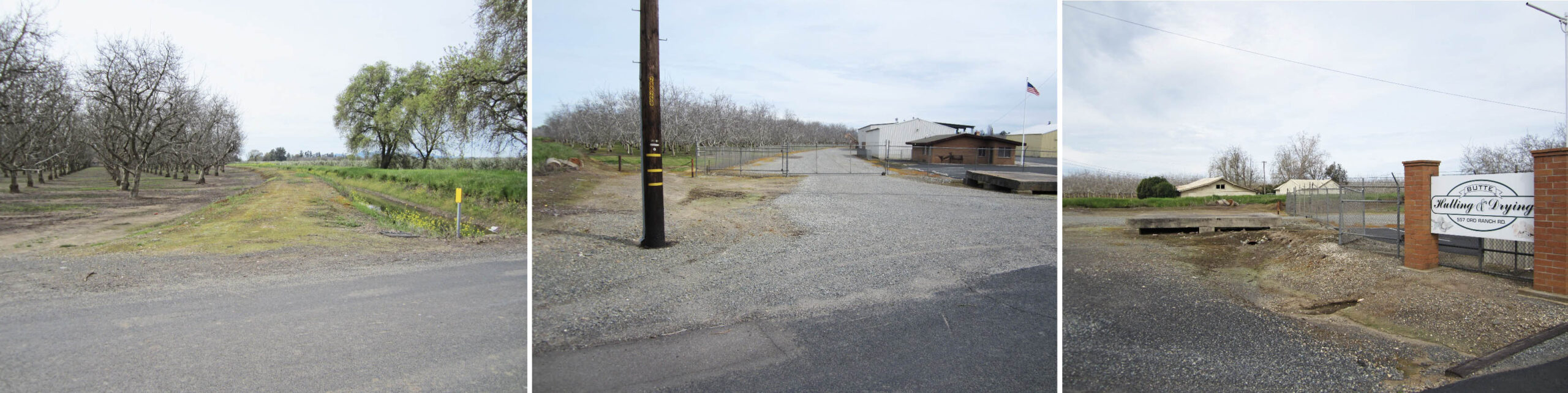
Regardless of the fate of customers at East Gridley, Peachton had business at least into the 1960s. From 2018, the left panel captures the gentle curve of the SN right-of-way from the southwest, the central panel the continuation of the curve past Ord Ranch Rd. to the northeast. In the panel on the right, a northwest view showing Butte Hulling and Drying, still around in 2025, also provides a good look at the concrete base that may have served a purpose during railway days. This will be shown next.
L324-150-Stuart Swiedler Photos, (Image 31 of 34)
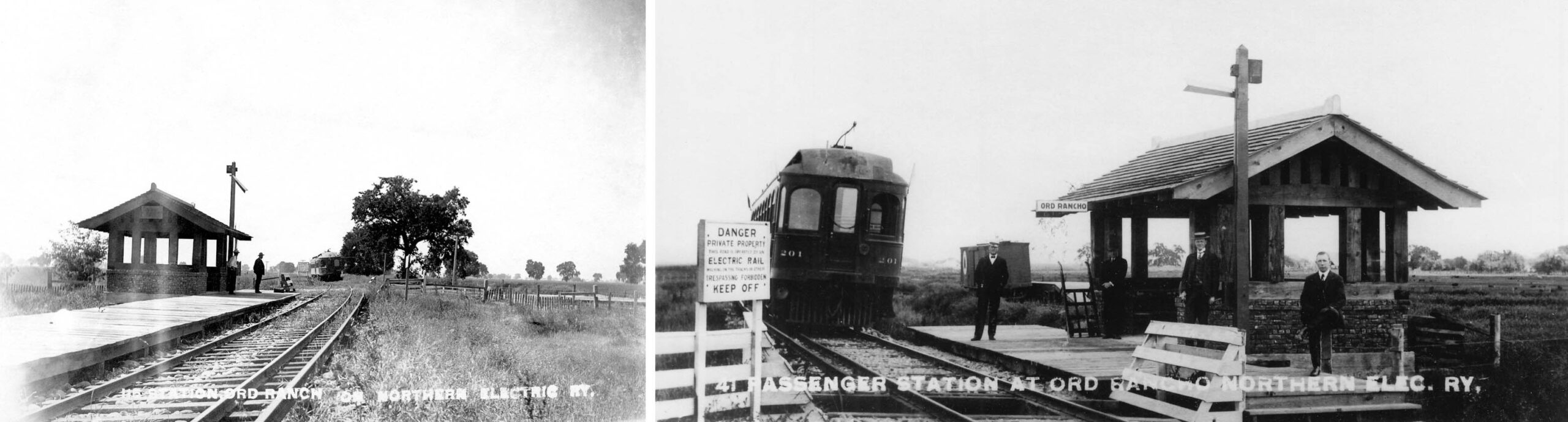
From 2018 back to the early NE days when the area was called Ord Rancho, the left panel captures the gentle curve of the NE right-of-way from the southwest, and in the panel on the right, a northeast view showing the station shelter. Note the concrete foundation of the shelter looks very similar in appearance and location to the concrete base seen in the right panel of the previous set of images. The name Ord Rancho was replaced by Peachton in the SN Employee Timetable no. 8, Sept. 20, 1925.
L324-155-NE Photo, Courtesy BAERA, Western Railway Museum Archives, 240231sn, l, 162604sn, r, (Image 32 of 34)
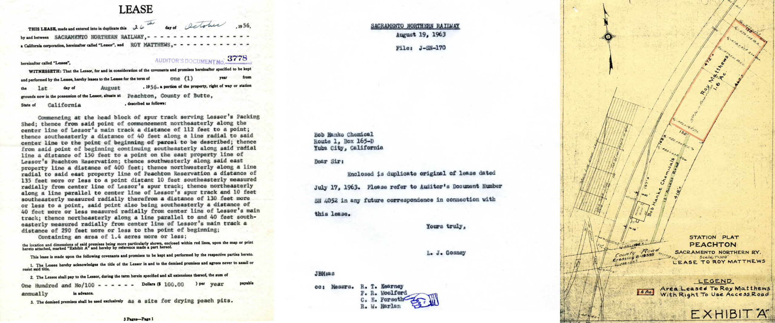
Based on these two written documents, and the diagram to the right, Bob Hanke Chemicals, a plant fertilizer business, and Roy Matthews’ peach pit drying operation may have contributed to the creation of the Live Oak—Peachton Branch when the SN mainline was switched to the SP right-of-way in 1967. Bob Hanke sold his business to John Taylor Fertilizer in 1968, and Taylor was bought out by Wilbur-Ellis in 1999. Another document not shown here from May 16, 1963 still shows correspondence with Mr. Mathtews.
L324-160-Courtesy BAERA, Western Railway Museum Archives, 39600, (Image 33 of 34)
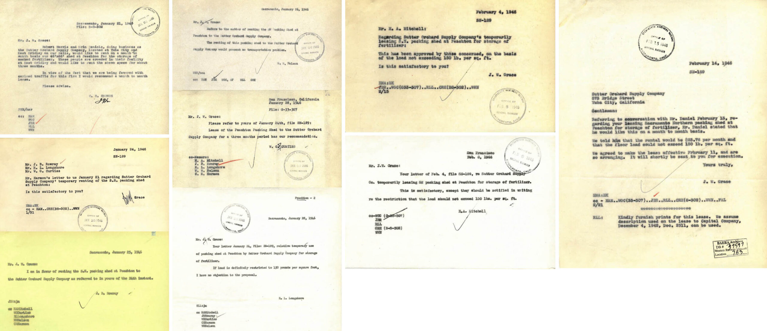
To close out this update, several documents from 1946 highlighting the fact that the SN owned the Peachton warehouses, and that the Sutter Orchard Supply Co. needed a short-term lease when they filled the warehouse at East Gridley. Appreciation to the continued generosity of Ted Benson for supplying unique images of the SN’s past. Next time, the final chapter in this series of updates reviewing the forgotten section north of Peachton to Haselbusch and the site of the future southern border of the Thermalito Afterbay.
L324-165-Courtesy BAERA, Western Railway Museum Archives 39597, (Image 34 of 34)