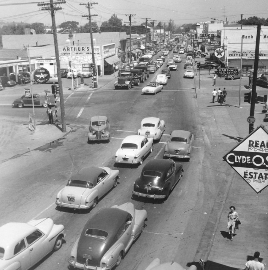
The Old Versus the New – Mt. Diablo Boulevard and Main Street 1950s

The intersection of Mt. Diablo Blvd. and Main Street in Walnut Creek in the 1950s was an important traffic corridor prior to I-680. Two approaches will be taken; one by overhead aerial matched with ground shots, and one by obliques. North view, 1954.
L18-05-Courtesy Planning Division, City of Walnut Creek , (Image 1 of 13)

This east view from Apr. 9, 1953 shows the T-intersection where Mt. Diablo Blvd. ended dividing Main Street into north and south. It had additional meaning in the 1950s by separating the old way of doing business to the north, or right, and the new way to the south, or left.
L18-10-Copyright California Department of Transportation, 3299-3 Detail, (Image 2 of 13)

A closer look directly above the intersection from Feb. 7, 1952 in the same north to south, right to left orientation. By the end of the decade, as the I-680 freeway crossed Walnut Creek, this configuration would be changed.
L18-15-Copyright California Department of Transportation, 2477-16 Detail, (Image 3 of 13)

An overhead view from Feb. 7, 1952 to Lincoln Avenue to the north, or right, also shows Walker Avenue or Railroad Avenue crossing the Walnut Creek to the south or bottom left. By 1960, the latter became Duncan Street, the connector to Broadway, and Cypress St., center, will pass east of Main St. to Broadway as well.
L18-20-Copyright California Department of Transportation, 2477-27 Detail, (Image 4 of 13)

This north view up North Main Street from Sept. 9, 1952. Strolling or shopping, or do you need a room at Hotel Las Palmas?
L18-25-Copyright California Department of Transportation, 2769-4 , (Image 5 of 13)

Turning to the south, Sept. 9, 1952, the last of North Main to the Mt. Diablo Blvd. intersection is in view with the Texaco sign, and then South Main with Pennys opposite the fixture Flying A sign. An aerial will provide a better appreciation of the area to the south ...
L18-30-Copyright California Department of Transportation, 2769-3 , (Image 6 of 13)

This Feb. 7, 1952 view shows the northern connection of Broadway to South Main separating Pennys, to the right, from Sears, to the left. This space is filled today by retail stores. The small extension of Broadway west of Main St. was known as Frederick, and is now the east terminus of Olympic Boulevard.
L18-35-Copyright California Department of Transportation, 2477-16 Detail , (Image 7 of 13)

The Broadway of Feb. 7, 1952 encircled the initial portion of Broadway Plaza Shopping Center and is now Broadway Plaza and not the Broadway of today, the latter being east of this scene. The aerial captures the meeting of Las Trampas Creek, to the middle left, Walnut Creek, to the right, and San Ramon Creek, bottom, following along the SP San Ramon Line operations.
L18-40-Copyright California Department of Transportation, 2477-17 Detail , (Image 8 of 13)

Looking straight east at the Mt. Diablo Blvd intersection with Main Street circa 1955-56 provides one of the later surveys of this area before major road reconfiguration was completed in the 1958-59 timeframe. Ref. #45 BANC PIC 1993.004 CC-C19-87, Detail.
L18-45-Clyde Sunderland Photo, Courtesy of The Bancroft Library, University of California, Berkeley, (Image 9 of 13)

Another view to the southwest at the same intersection, circa 1955-56. Ref. #41, BANC PIC 1993.004, CC-C19-91, Detail.
L18-50-Clyde Sunderland Photo, Courtesy of The Bancroft Library, University of California, Berkeley, (Image 10 of 13)

An oblique east view of the entire east side of North Main Street from Mt. Diablo Blvd., top right, to Lincoln Avenue, bottom left. These views allow a general comparison with the 1952 images and include the backs of the buildings on the west side. Ref. #45 BANC PIC 1993.004 CC-C19-87, Detail.
L18-55-Clyde Sunderland Photo, Courtesy of The Bancroft Library, University of California, Berkeley, (Image 11 of 13)

To complement the previous image, most of the west side of North Main Street from Mt. Diablo Blvd., top left, is provided. Ref. #41, BANC PIC 1993.004 CC-C19-91, Detail.
L18-60-Clyde Sunderland Photo, Courtesy of The Bancroft Library, University of California, Berkeley, (Image 12 of 13)

A final east view of the former configuration of Broadway wrapping around the Broadway Plaza Shopping Center as a connector of South Main Street. This area will be revisited later after reviewing images of the same period to the west. Ref. #45 BANC PIC 1993.004 CC-C19-87, Detail.
L18-65-Clyde Sunderland Photo, Courtesy of The Bancroft Library, University of California ,Berkeley, (Image 13 of 13)