The Sacramento Northern Lives in Live Oak
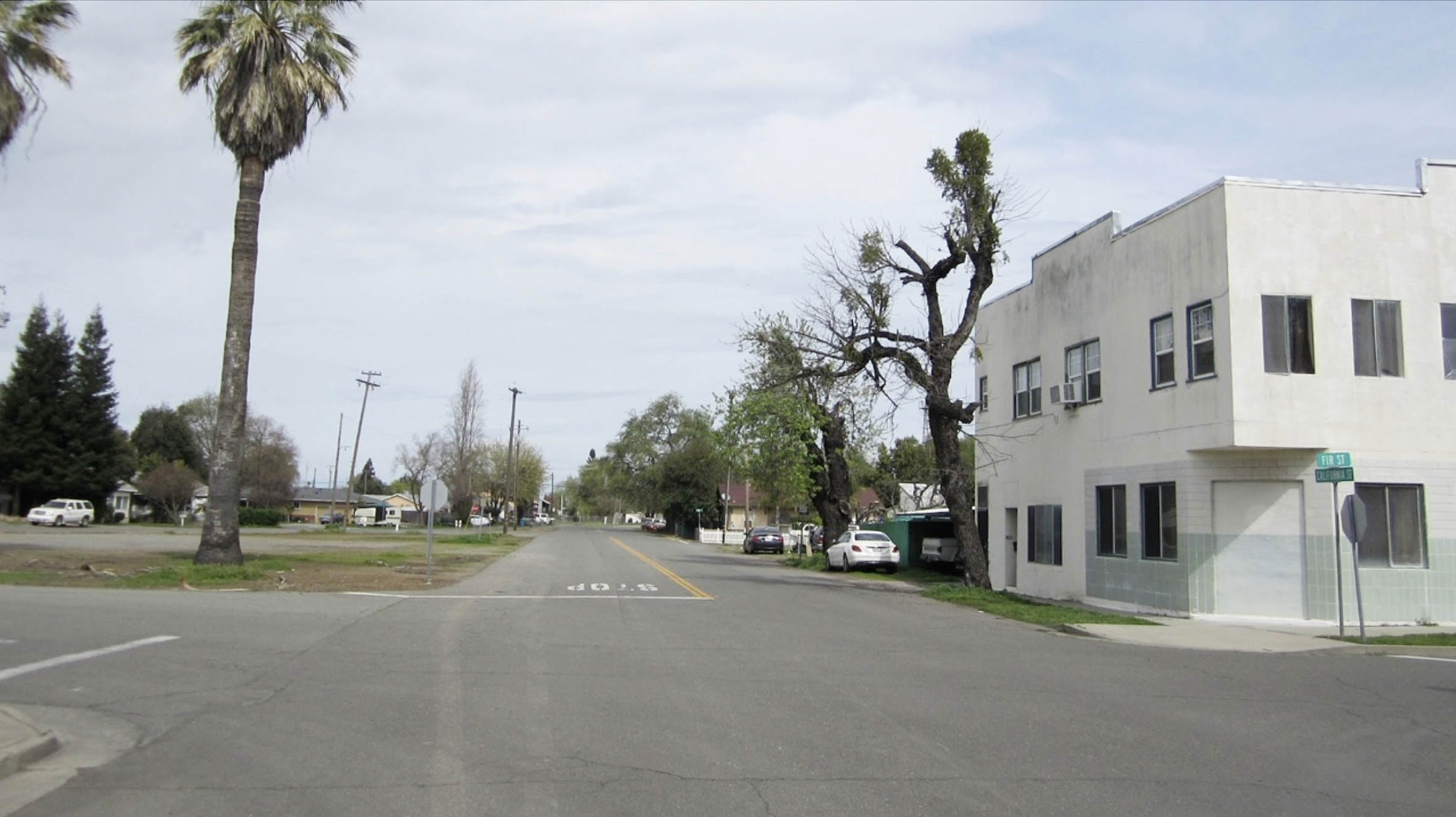
A north view in 2018 at California and Fir Sts. in Live Oak, CA provides no clues as to the daily activity at this spot during the first half of the 20th century. However, this city serves as an outdoor history museum of the defunct Sacramento Northern Railway, SN, and this update will attempt to preserve it digitally by documenting a walk along the right-of-way in 2018, drawing connections to the railway’s functional past. Also, a little Southern Pacific Railroad, SP, to boot.
L322-05-Stuart Swiedler Photo, (Image 1 of 56)

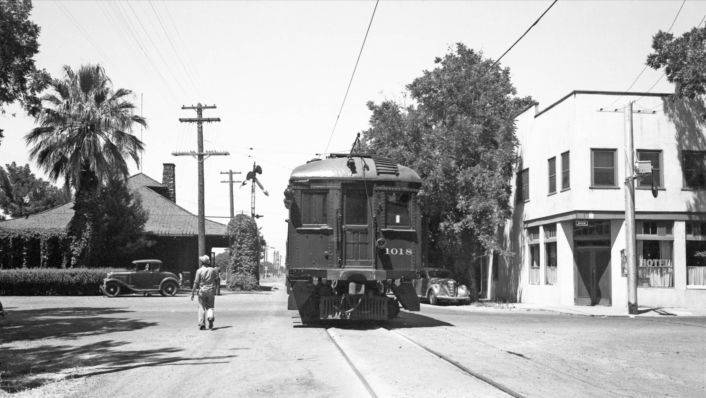
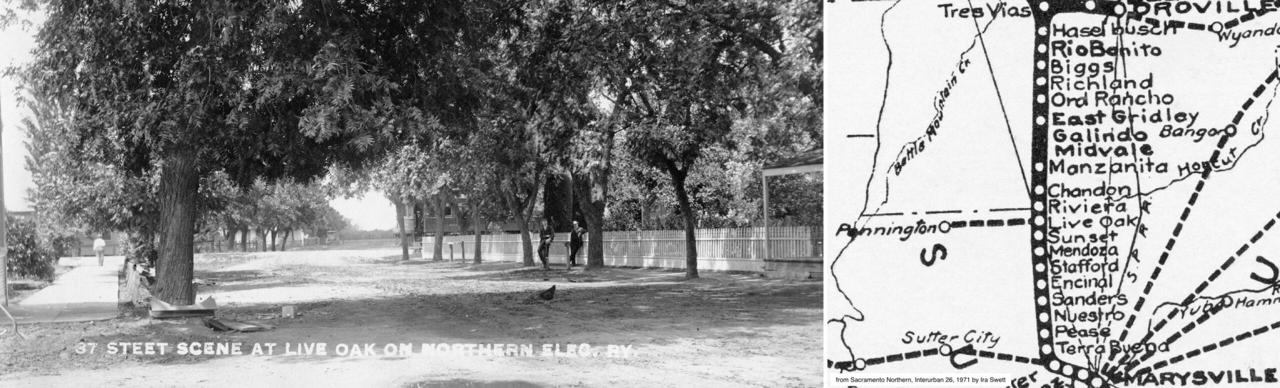
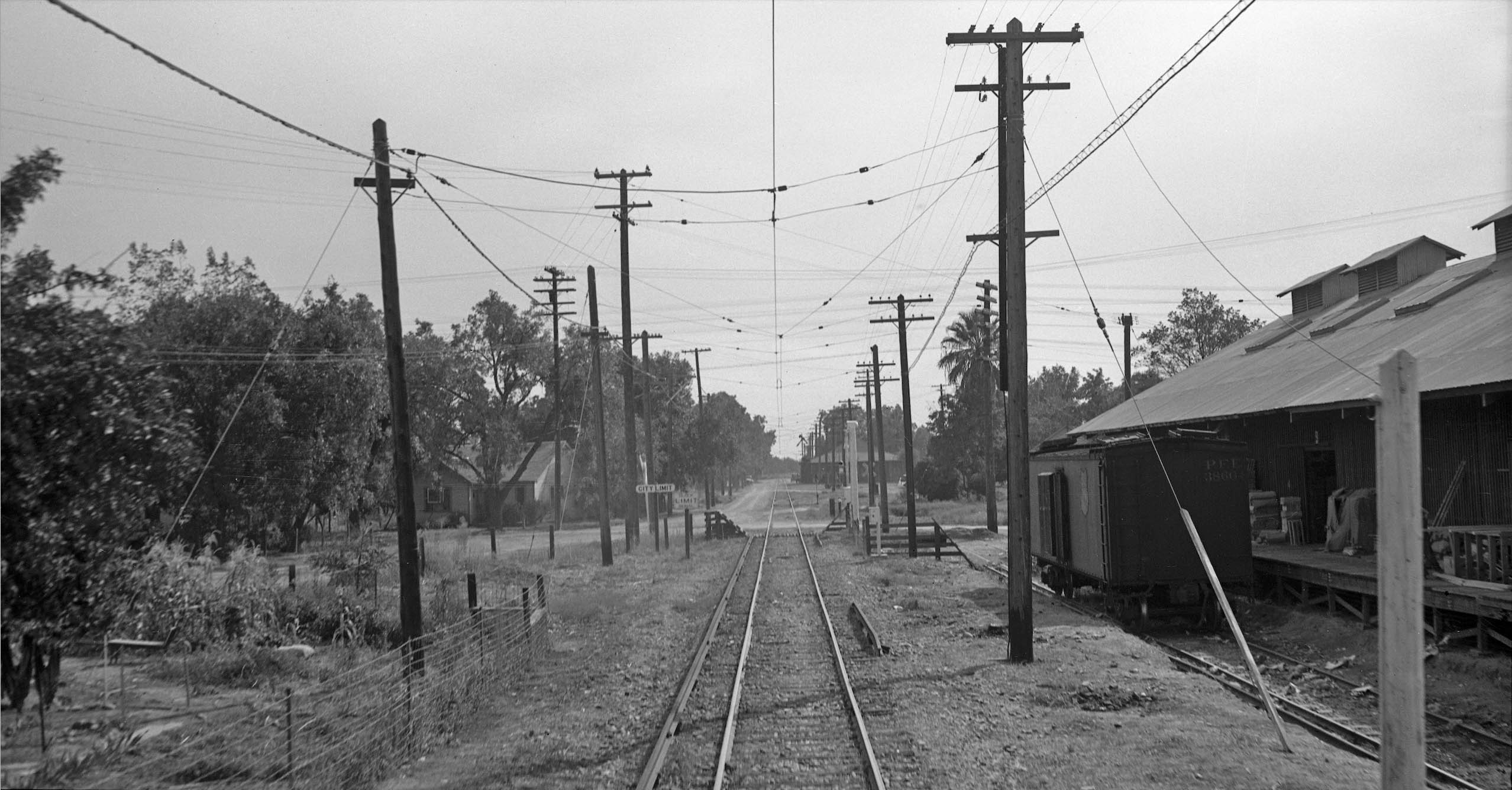
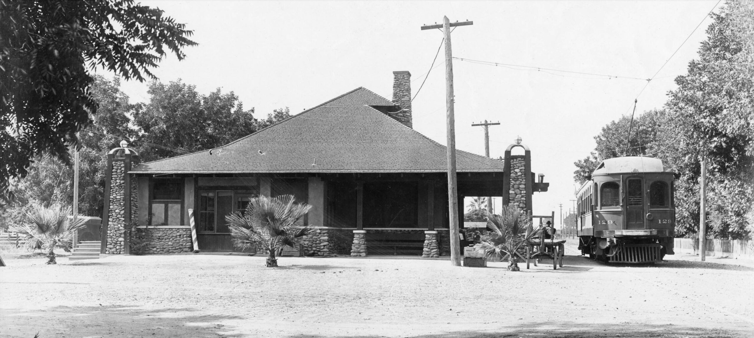
Same north view, Aug. 4, 1940, Live Oak’s depot was one of the Northern Electric Railway, NE, General Manager A.D. Schindler’s craftsman bungalow designs with its stone and framed stucco construction. A passenger train, here SN 1018, on California St. at Fir St., north view. The palm trees persist, but, sadly, the depot did not make it past the 1950s. A visit in 2025 does feature the right-of-way and warehouse sheds that remain as well as an outdoor exhibit, and the former SP station.
L322-10-Wilbur C. Whittaker Photo, Vielbaum Coll., Courtesy BAERA, Western Railway Museum Archives, 132813sn, (Image 2 of 56)
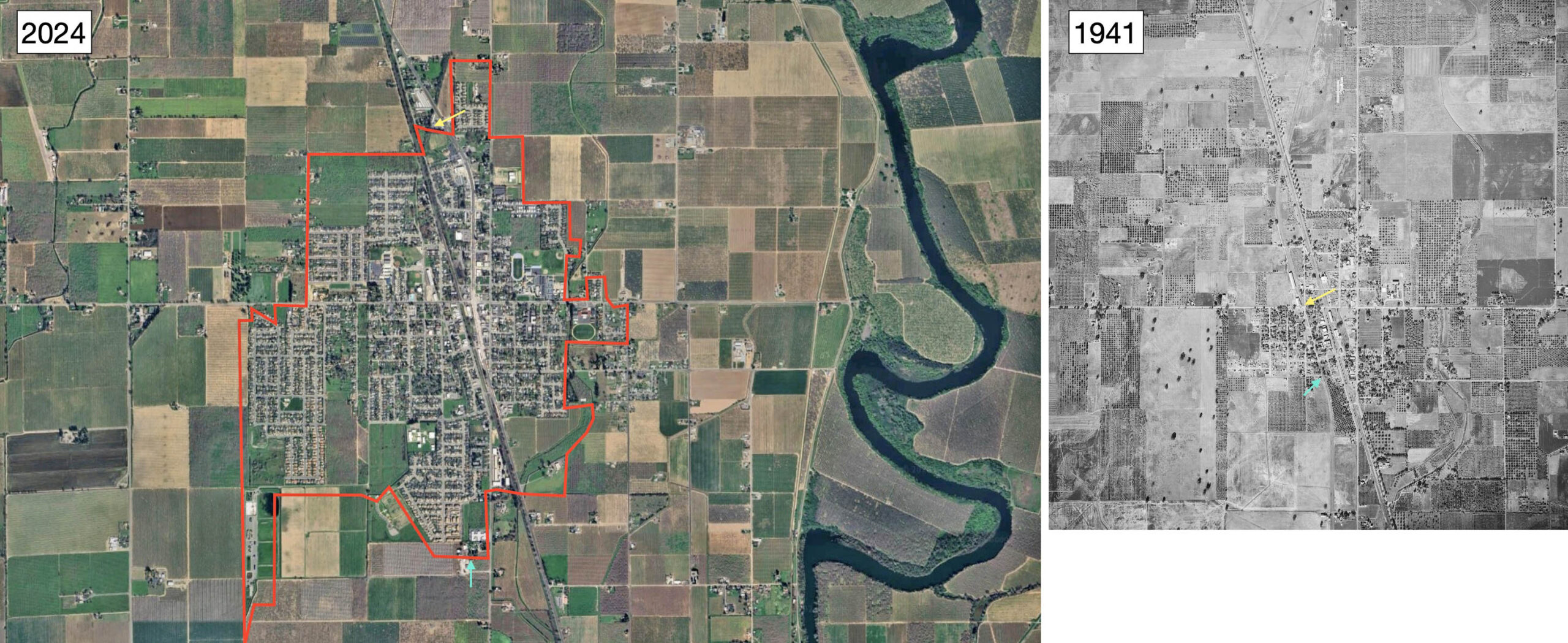
The Live Oak under discussion in this update is at the northeastern-most border of Sutter County, west of the Feather River. Unlike the similarly named census-designated place in Santa Cruz County, it was incorporated in 1947, and is primarily an agricultural-rural community of about 9000 inhabitants. The city border in 2024 is marked in red, left, the yellow arrow indicating were the SN had crossed to the north, the turquoise arrow to the south. A much smaller place in 1941, right, the City Limit speed zone for trains is marked by the corresponding arrows.
L322-15-Courtesy Google Maps, l, c-7490_419, Courtesy of UCSB Library Geospatial Collection, r, (Image 3 of 56)
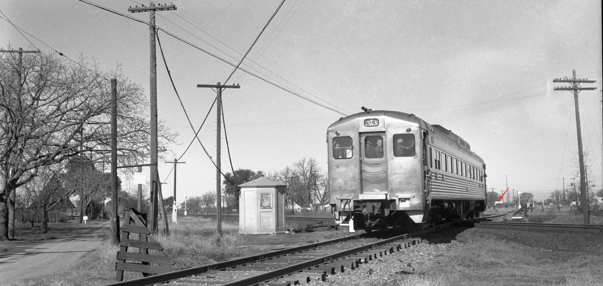
Although not unique, a SN-SP mainline crossing existed just south of the 2024 northern city border. Note the City Limit sign, red arrow, in this northeast view of a Bay Area Electric Railroad Association excursion in the North End with Budd RDC-1 railcar demonstrator on Jan. 29, 1950. That would place the sign at the actual city border in 2024. The SN and SP paralleled each other through the town, the SP eventually joining the the west flank of Highway 99, the SN looping more to the west. The SN-SP crossed is covered elsewhere, click here.
L322-20-Robert L. Stein Photo, Courtesy BAERA, Western Railway Museum Archives, 76012sn, (Image 4 of 56)
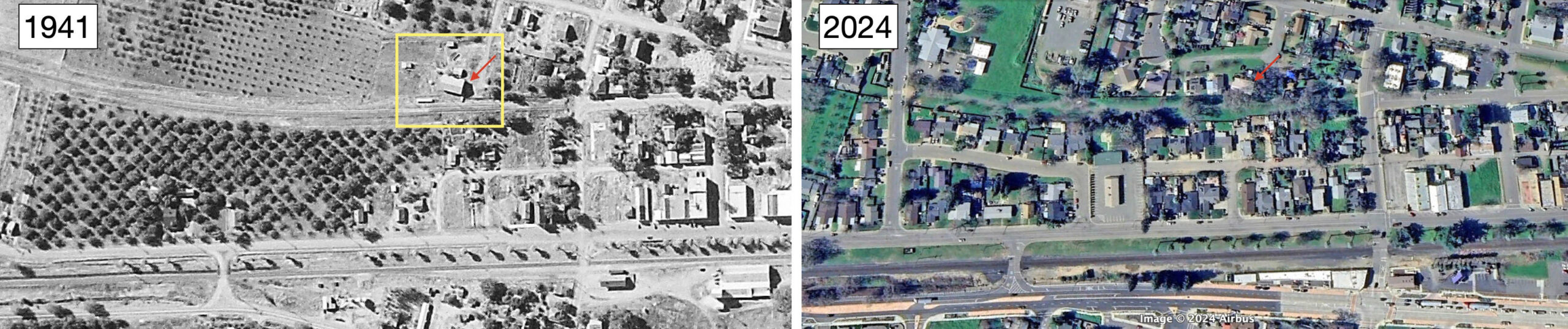
Presented here are two aerials showing the locations for the SN and SP mainlines, from 1941 and 2024, respectively, the latter now the Union Pacific, rotated ninety degrees such that north is to the right. The first part of this update will follow the red dotted line during 2018, north to south, to the private right-of-way to the south or Apricot St. The blue arrow by the SP depot in 1941 indicates it had been moved 50 feet as seen in 2024.
L322-25-c-7490_419, Courtesy of UCSB Library Geospatial Collection, top, Courtesy Google Earth, bottom, (Image 5 of 56)
The starting point for the walk heading southwest in 2018 was Hampton Rd., left, on the repaired surface for the revised SN right-of-way from 1967. It is paired with an early 20th century NE southwest view, right. The print of the latter was labeled “Sangler Home”, but the significance of this notation has not been uncovered. By the way, this walk took place in early April, a good time to visit the area when all is green.
L322-30-Stuart Swiedler Photo, l, Moreau Collection, Courtesy BAERA, Western Railway Museum Archives, 144257sn, r, (Image 6 of 56)
Crossing Epperson Way and heading south, the abandoned SN right-of-way was expanded to two tracks to accommodate a runaround track in 1967 when the SN-SP crossing was converted to an interchange. Unfortunately no ground images of this section when the railway was active were found. For more on the creation of the SN mainline bypass between here and Durham on the SP right-of-way, click here.
L322-35-Stuart Swiedler Photos, (Image 7 of 56)
This east-facing aerial view on the left from May 23, 1973 does provide some appreciation for how this section may have appeared during the electric era. The area marked by the yellow box is magnified on the right for this purpose, showing that this section was still relatively undeveloped at this time.
L322-40-Copyright California Departent of Transportation, 18734, (Image 8 of 56)
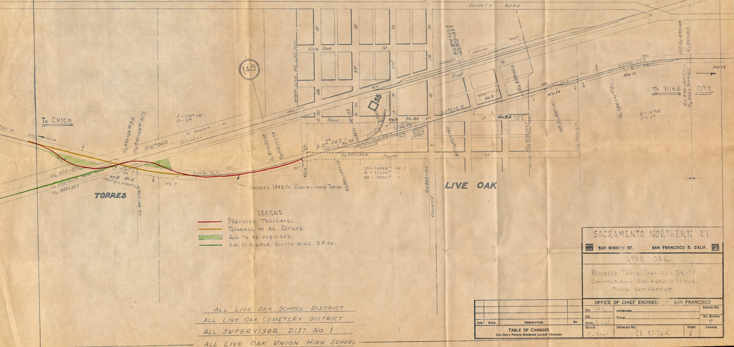
This figure from Feb. 11, 1965 was used as a planning document for the impending 1967 detouring of the SN on the SP between Live Oak and Durham to the north. Aside from the proposed runaround track, it shows the early grid for the town. Note the major “County Road” along the top running left to right is Larkin Rd., and the one running top to bottom or east-west is Pennington Rd. At this date there was no Highway 99. The naming of streets is somewhat confusing, as if there was one city east of the SP right-of-way, and one west.
L322-45-Courtesy BAERA, Western Railway Museum Archives, 39641,, (Image 9 of 56)
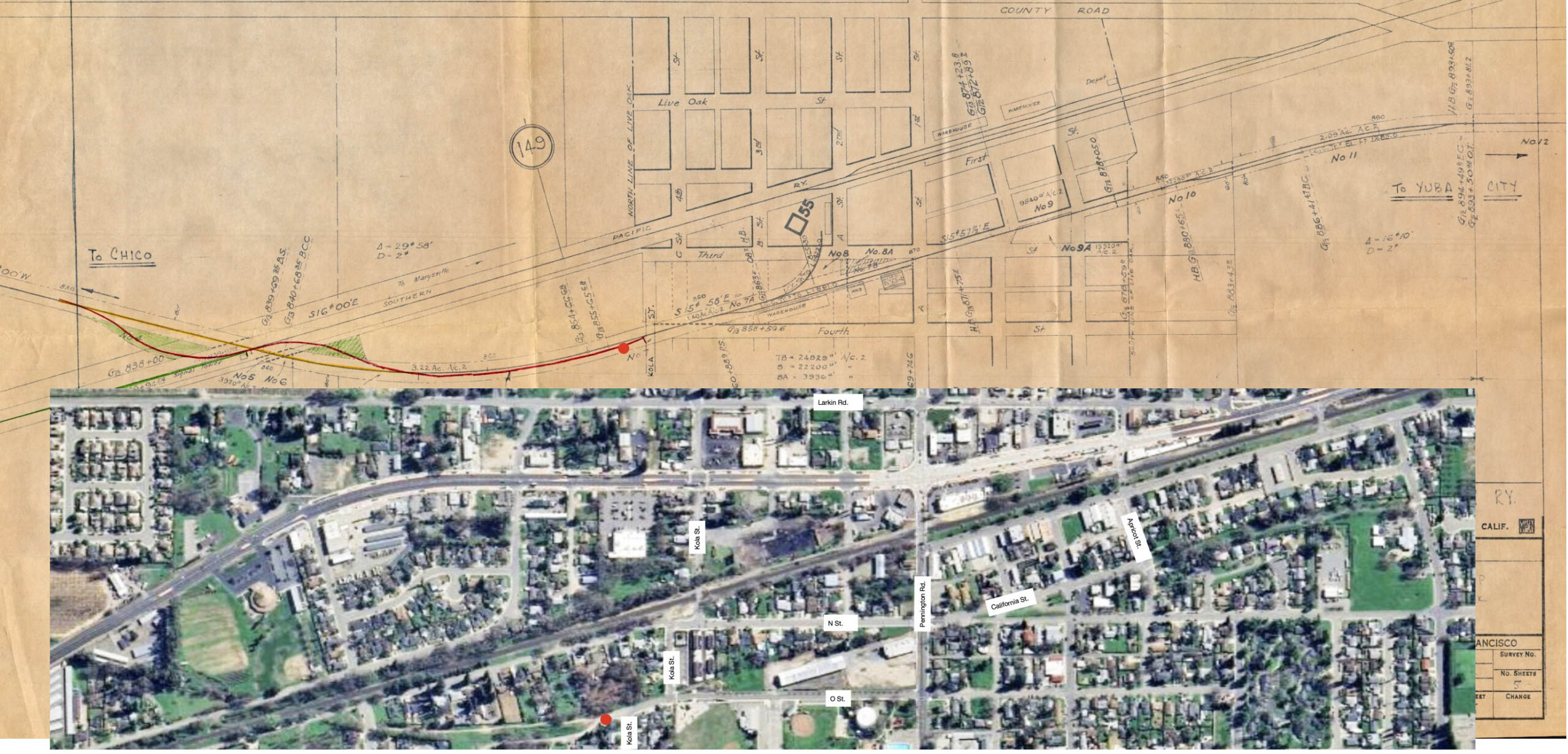
To appreciate “now”, 2024, below, versus “then”, above, a comparison between the two is presented here. Note in the 2024 panel the beginning of asphalt at O St. just north or left of Kola St.
L322-50-Courtesy BAERA, Western Railway Museum Archives, 39641, top, and Google Earth, bottom, (Image 10 of 56)
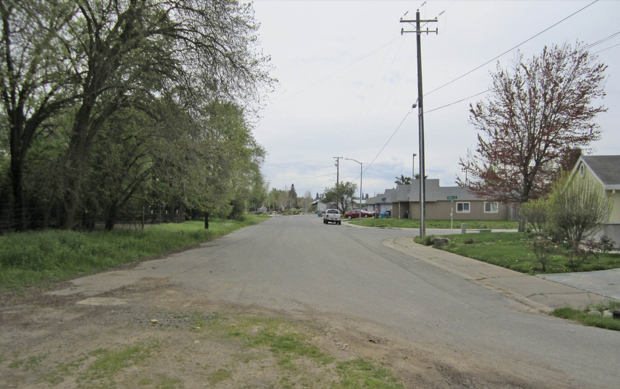
Continuing on the walk from 2018, finally the asphalt appears as does the signage for O St. and the intersection to the south with the disjointed west section of Kola St.
L322-55-Stuart Swiedler Photo, (Image 11 of 56)
Trains ran along the then primitive city streets even at the onset of rail operation, left. The NE founders had high expectations for Live Oak, even contemplating a branch line west eight miles to the town of Pennington at the north edge of the Sutter Buttes, right. This dream was never realized for the financially strapped railway. It got a one line mention in the Aug. 14, 1912 Daily People’s Cause newspaper from Red Bluff. Garth Groff notes that the town post office closed around 1921. In 2025, the town consists of a few homes and farms.
L322-60-Courtesy BAERA, Western Railway Museum Archives, 239406sn, (Image 12 of 56)
Next this north view from Mar. 3, 1958, left, will audition what is about to be shown in detail. The portion in the yellow box is magnified on the right. The SN right-of-way can be seen crossing the intersection with Kola St., red arrow, and enters an area served by two warehouses on the left, or west, and one industrial concern on the right, or east. Note the presence of a siding, yellow arrow, along the entire length on the west side of the mainline. Next, back to the city streets in 2018.
L322-65-Copyright California Department of Transportation, 5884-2, (Image 13 of 56)
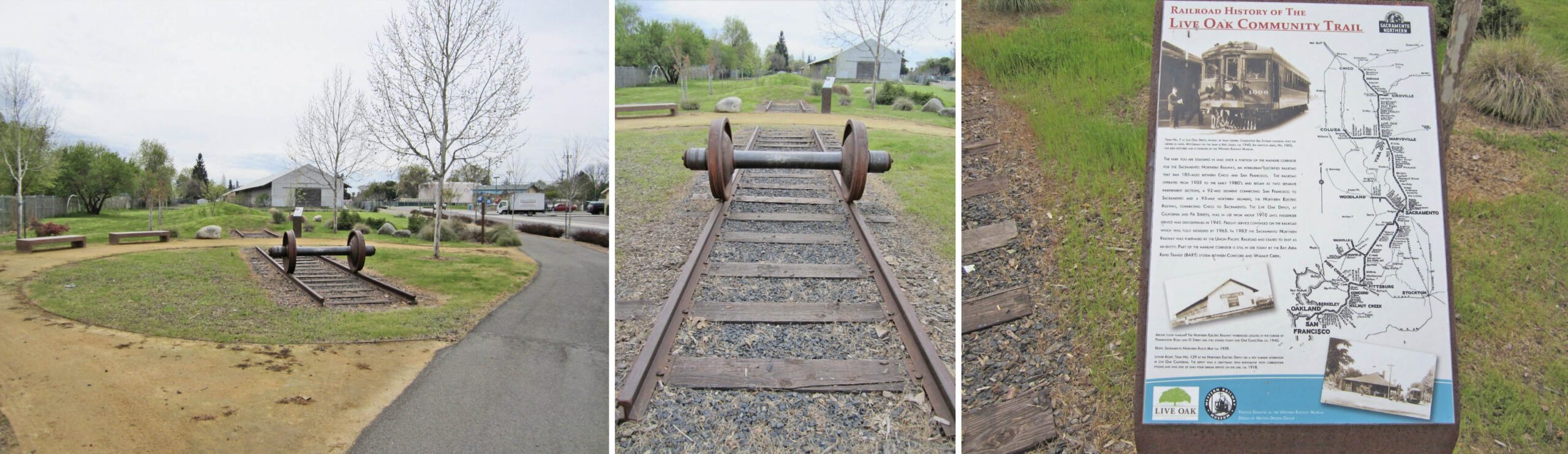
Walking a short distance down O St. to the intersection with the discontinuous east portion of Kola St., the right-of-way shifted to the east or left, to a park created to memorialize the SN. The first warehouse can be appreciated behind the park.
L322-70-Stuart Swiedler Photo, (Image 14 of 56)
The park is a gem, and clearly created by folks who appreciated the contribution of the railway to the area. All south views, 2018.
L322-75-Stuart Swiedler Photos, (Image 15 of 56)
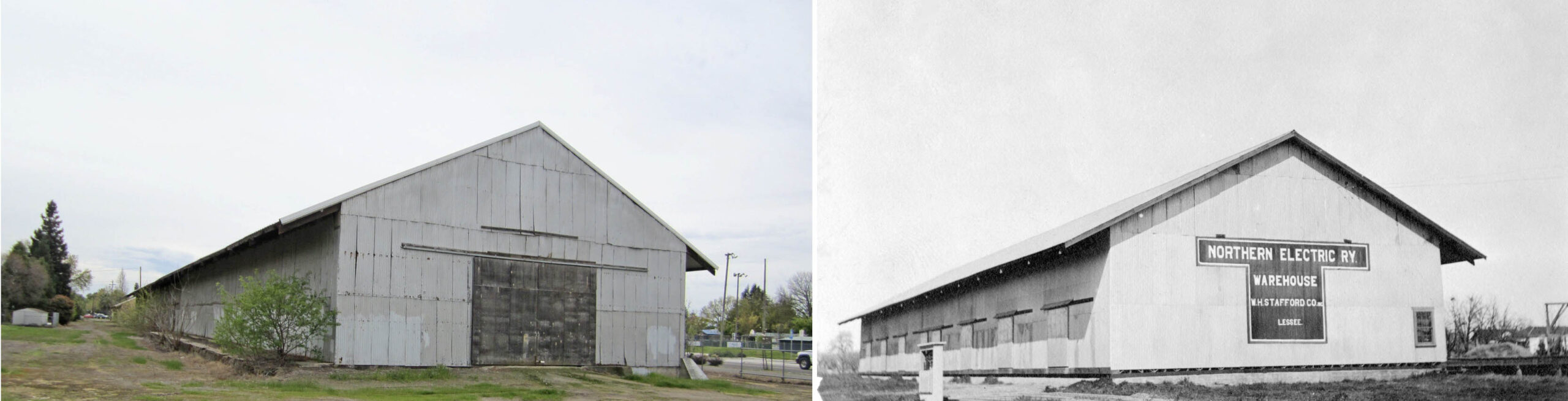
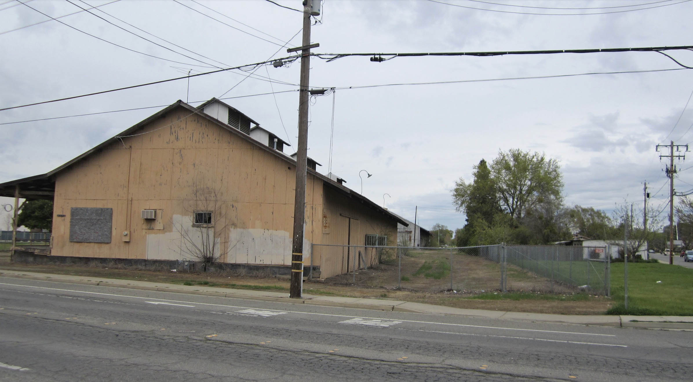
Continuing the walk south in 2018 following the SN route, the northern-most warehouse is reached, left. Interestingly, the image from the NE era, right, is viewed north and highlights the west side of the warehouse, the side not serviced by the railway siding. Note the 2018 building is much longer, a topic to be addressed shortly. Having reached the industrial center of both the SN and SP operation north of Pennington Rd., the panels that follow trace the history of the buildings to be seen in upcoming aerial views that will follow.
L322-80-Courtesy BAERA, Western Railway Museum Archives, 75085sn, (Image 16 of 56)
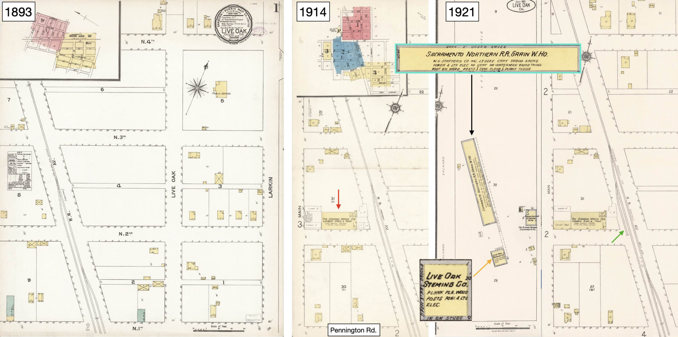
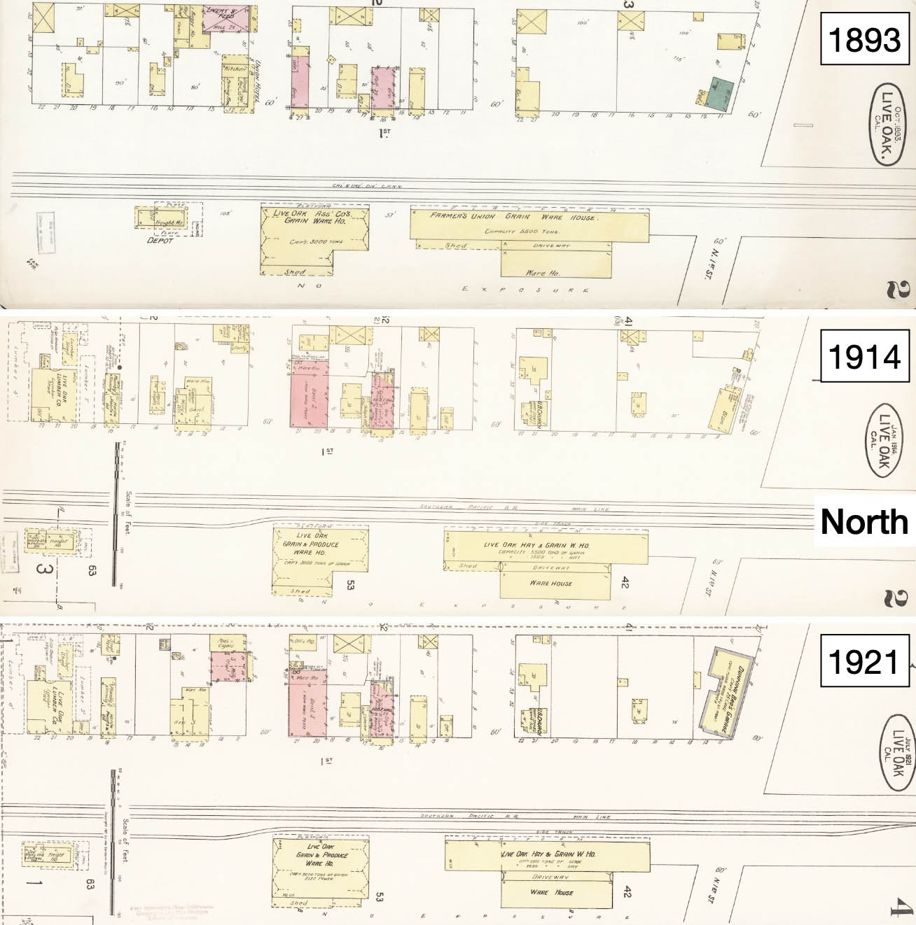
Reviewing Sanborn maps, there were no businesses along the SP in 1893, left, north of Pennington Rd. In 1914, center, there was no coverage of the NE, but Diamond Match Co., red arrow, appears along the SP. By 1921, right, Stafford leased the warehouse from the SN, black arrow, and the Live Oak Stemming Co. building was present, orange arrow. A dedicated siding from SP to Diamond Match, green arrow, had been added. To clarify, the SP route was the Oregon and California Railroad, controlled, but not owned, by the SP from 1887-1927.
L322-85-Courtesy Library of Congress, Geography and Map Division, Sanborn Maps Collection, (Image 17 of 56)
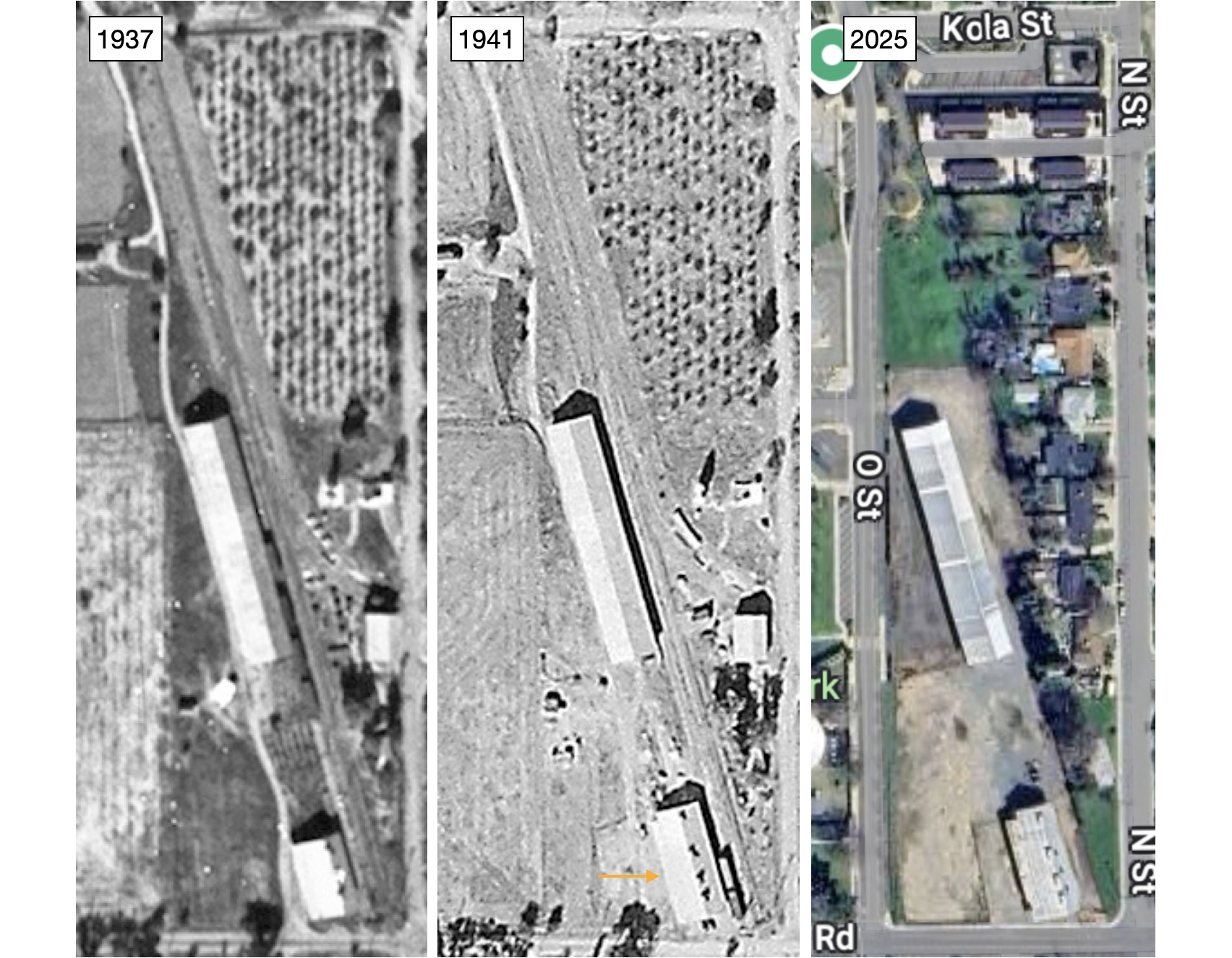
It was mentioned in L322-80 that the northern-most warehouse seen in 2018 is significantly larger than it was in the NE era. This side-by-side aerial comparisons from Nov. 2, 1937, left, versus 1941, center, and 2024, right, show that the warehouse had reached its current length by 1937. No other images or documents of the warehouse were found. The southern-most warehouse, orange arrow, was lengthened between 1937 and 1941 as shown here. Still need to figure out who actually owned that building.
L322-86-Courtesy the National Archives, AAZ-127-38, l, c-7490_419, Courtesy of UCSB Library Geospatial Collection, c, Courtesy Google Maps, r, (Image 18 of 56)
Two views of the Diamond Match Co. facility in Live Oak in 1914. The Company dates back to 1881 as a rebranded name for the largest match manufacturer in the US that began in 1853. It made its inroads to California in 1901 building a mill in Stirling City and created a manufacturing plant in Chico, taking over others such as in Red Bluff. They established lumberyards throughout Northern California. “Matches, Flumes and Rails” by Kent Stephens on the Company’s California roots is a recommended. For more Diamond Match views, click here.
L322-90-W. B. Dean Photos, Northeastern California His. Photo. Coll. via Margaret Brinks, Courtesy Meriam Library, California State University, Chico sc6565, l, sc 6566, r, (Image 19 of 56)
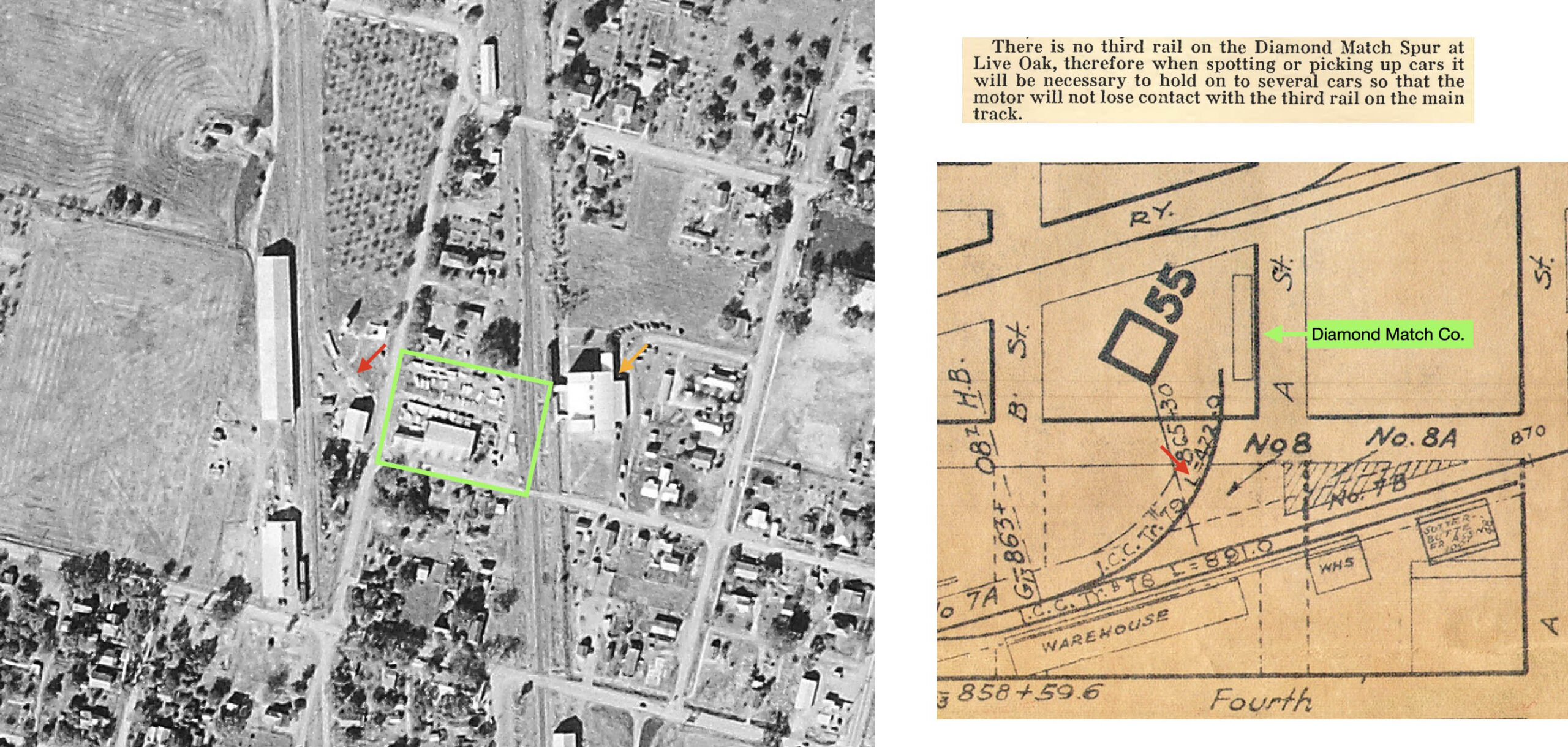
The directive in the SN Employee Timetable No. 10, Dec. 28, 1930 instructs on the use of the non-electrified spur to Diamond Match Co., top right. The spur from the SN mainline was already present in the figure in L322-45, seen here at the bottom right. The aerial from 1941, left, shows Diamond Match Co. and the SP siding, green box, as well as the SN spur, red arrow. A new building along the SP is also present, orange arrow.
L322-92-c-7490_419, Courtesy of UCSB Library Geospatial Collection, l, Courtesy BAERA, Western Railway Museum Archives, 13462, top, 39641, bottom, (Image 20 of 56)
The south aerial view on the left from Mar. 7, 1958 provides the clearest picture of all the possible elements served by the railroads north of Pennington Rd. The area boxed in yellow is magnified on the right. The large building is Diamond Walnut Growers, Inc., with its own long siding, right. The plant was built in the 1920s. The siding to Diamond Match Co. looks very overgrown, red arrow, not surprising since they no longer used rail service. More on this later.
L322-95-Copyright California Department of Transportation, 5884-1, (Image 21 of 56)
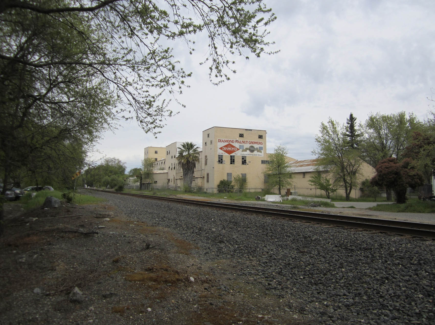
This north view of Diamond Walnut Growers, Inc. taken in 2018 shows the building to be abandoned. The building was subsequently destroyed in a fire on Feb. 4, 2022. The California Walnut Growers Association was formed in 1912 after reorganization of the association in Southern California. It adopted the “Diamond Brand” at that time, but it wasn’t until 1956 that the name was changed to Diamond Growers, Inc. It transitioned to a publicly-owned corporation, Diamond Foods, in 2005. For an excellent review of the California Walnut Industry, click here.
L322-97-Stuart Swiedler Photo, (Image 22 of 56)
Moving west in the south aerial view from Mar. 7, 1958. On the left is the entire Diamond Match Co. facility. Crossing N St,. as it is known in 2024, following along the SN spur from the mainline leads too a lone boxcar. Since they were no longer a customer, this spur may have morphed to a team track. More on this soon. The manual switch stand from mainline to spur is visualized in the lower right corner. The two warehouses seen in the previous 1941 aerial are unchanged, the long siding continuing south and ending at Pennington Rd.
L322-100-Copyright California Department of Transportation, 5884-1, (Image 23 of 56)
An east view of everything just covered from May 23, 1973.
L322-105-Copyright California Department of Transportation, 18734, (Image 24 of 56)
Back to the walk along the right-of-way in 2018, after reaching Pennington Rd., the view looks back north along the second warehouse still remaining from the SN days.
L322-110-Stuart Swiedler Photo, (Image 25 of 56)
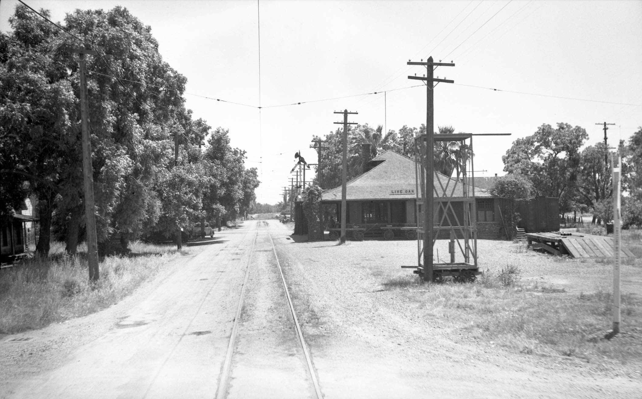
Next, back in time to Sept. 1940, a south view at that southern-most warehouse. Relative to the northern-most City Limit sign in 1950 shown earlier, trains in 1940 were not notified until Pennington Rd., as well as indicating the block signal limit. Across the road, a switch to access the spur to the west side of the depot is seen.
L322-115-Vernon Sappers Collection, Courtesy BAERA, Western Railway Museum Archives, 106511sn, (Image 26 of 56)
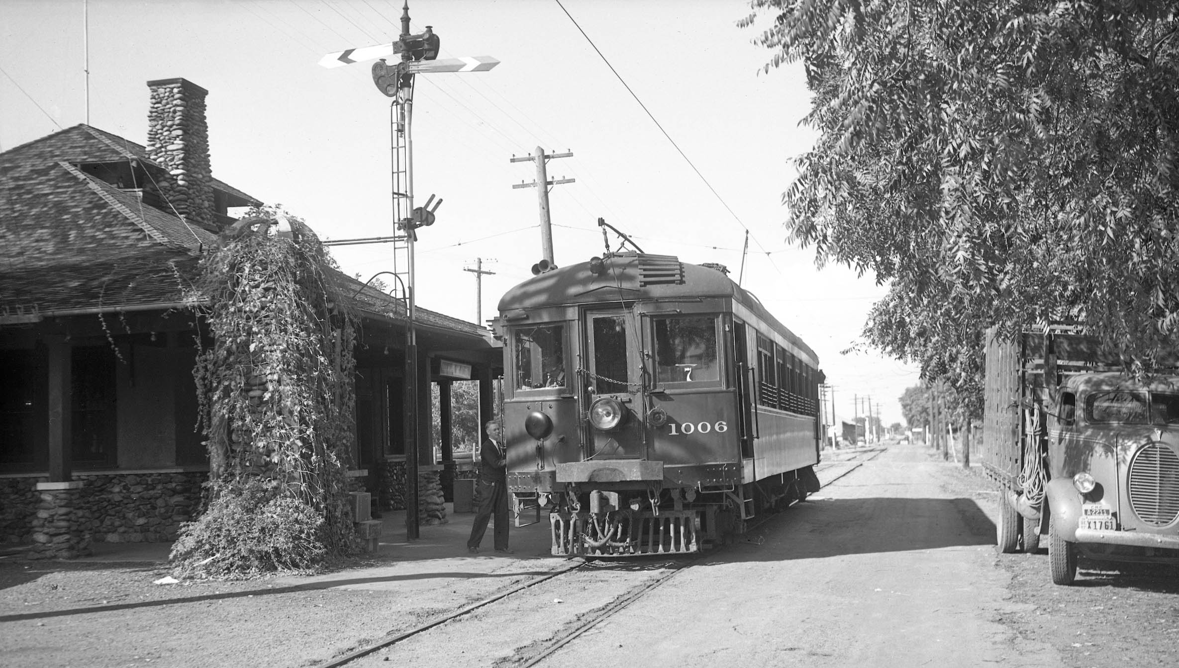
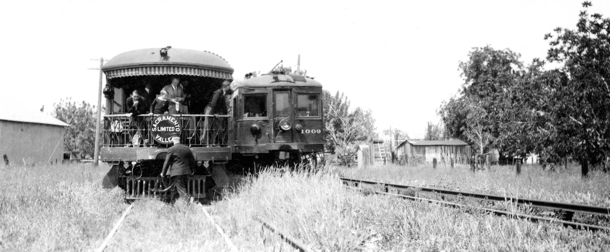
Crossing the road, the path to the depot was documented by Howard Wolfe from the rear of SN 225, used here as a closed observation car, leased and chartered on Train 11 on June 2, 1940. Note the lone boxcar at the end of the spur along the depot on the right edge of the image.
L322-117-Howard Wolfe Photo, Courtesy BAERA, Western Railway Museum Archives, 238470sn, (Image 27 of 56)
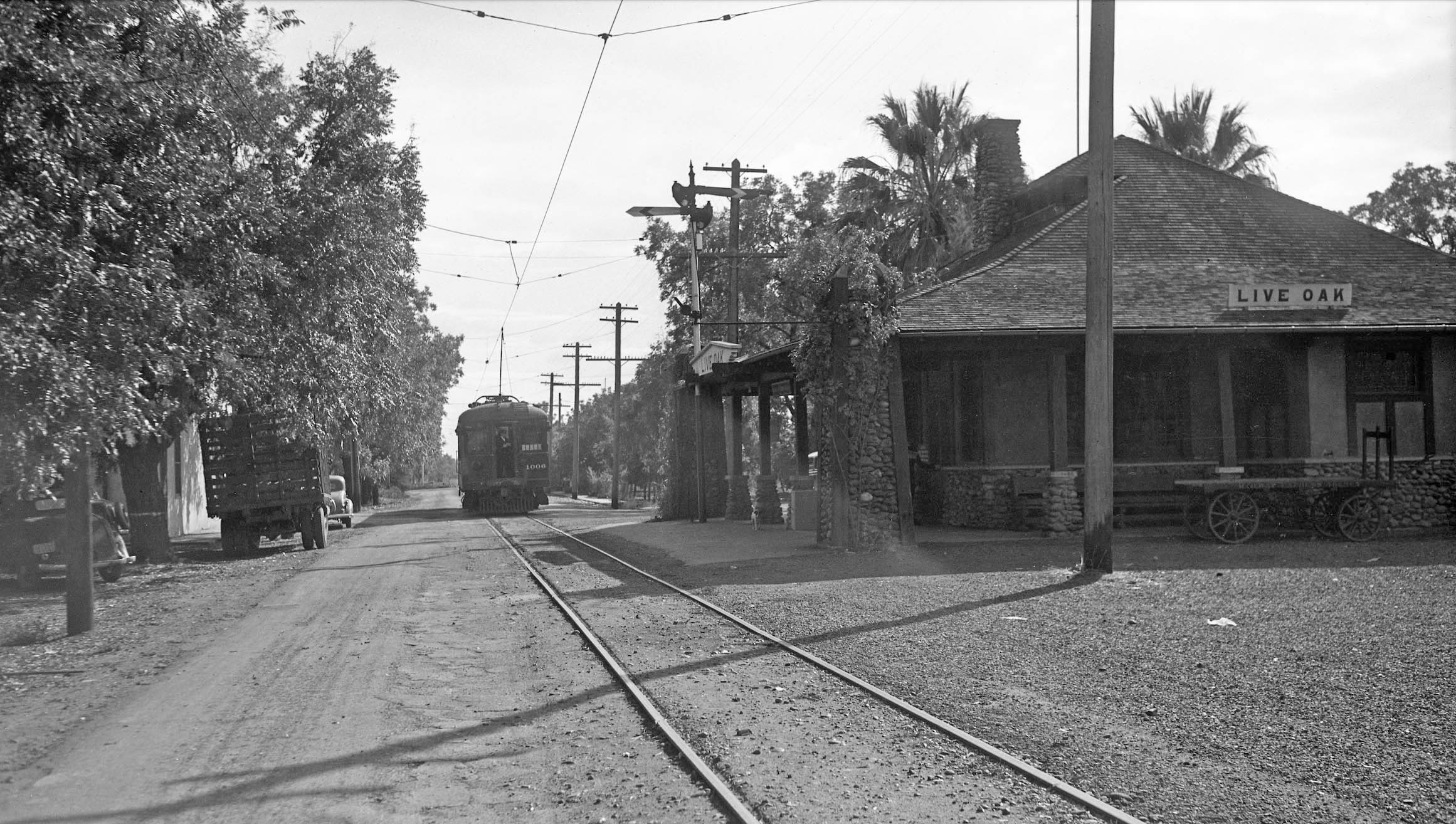
SN 1006 on the rear of a passenger train is seen pulling away from Schindler’s stylish structure in this south view from Oct. 1940.
L322-120-Vernon Sappers, Courtesy BAERA, Western Railway Museum Archives, 106476sn, (Image 28 of 56)
Viewed from the south, this NE-era north view with NE 129 shows the depot before it was engulfed with vegetation.
L322-125-American Photo Co., Courtesy BAERA, Western Railway Museum Archives, 75082sn, (Image 29 of 56)
Ever popular was snapping a photo of the depot on board a train as it stopped for passengers, as seen in this north view from June 2, 1940. The best ones captured the semaphore, passenger or conductor action, and a glimpse to the warehouse area to the north.
L322-130-Don MacInnis Collection, Courtesy BAERA, Western Railway Museum Archives, 169047sn, (Image 30 of 56)
SN 1006 as train no. 7 takes a breather at the depot in this north view from 1940. Here a good view of the route ahead is documented, including that City Limit sign.
L322-135-Addison Laflin Photo, Courtesy BAERA, Western Railway Museum Archives, 106474sn, (Image 31 of 56)
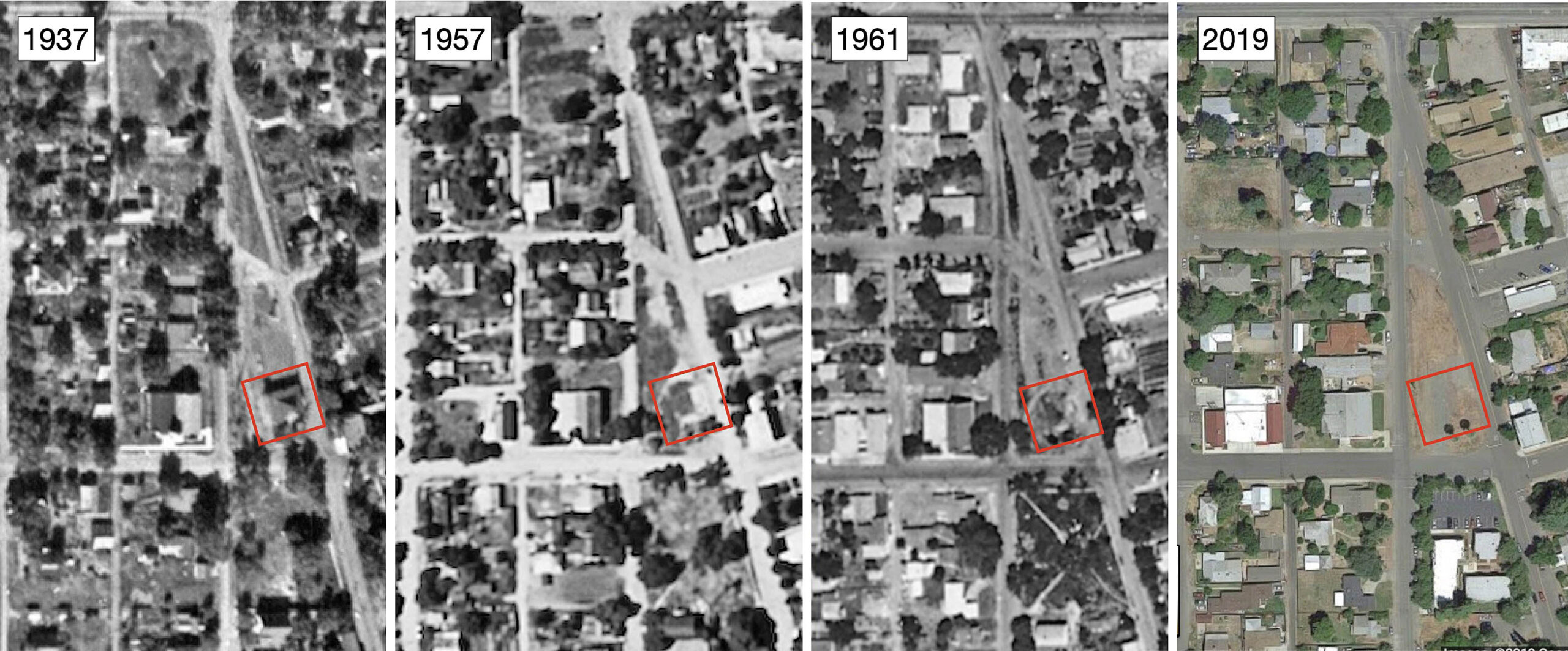
It is unfortunate that the depot did not survive past the 1950s, removed by the SN as will be documented shortly. Aerials from above as shown here provide a 1950s departure of the building. Attr: Courtesy the National Archives, AAZ-127-38, 11/02/1937 l; cas-1957 live-oak, 05/21/1957, lc, and cas-but_3-157, 06/28/1962, rc, both Courtesy of UCSB Library Geospatial Collection; Courtesy Google Maps, r
L322-140-Multiple Attributions, (Image 32 of 56)
More convincing, the Holmes Brothers took this undated north view that included an auto with a 1951 license plate, left. To the right, a detail from the south aerial view from Mar. 7, 1958 dramatically seals the deal. For more detailed exterior views of one of Schindler’s depots, the Holmes Bros., images of the similar building at East Nicolaus were presented elsewhere, click here.
L322-145-Holmes Bros. Photo, Courtesy BAERA, Western Railway Museum Archives, 240501sn, l, Copyright California Department of Transportation, 5884-1, r, (Image 33 of 56)
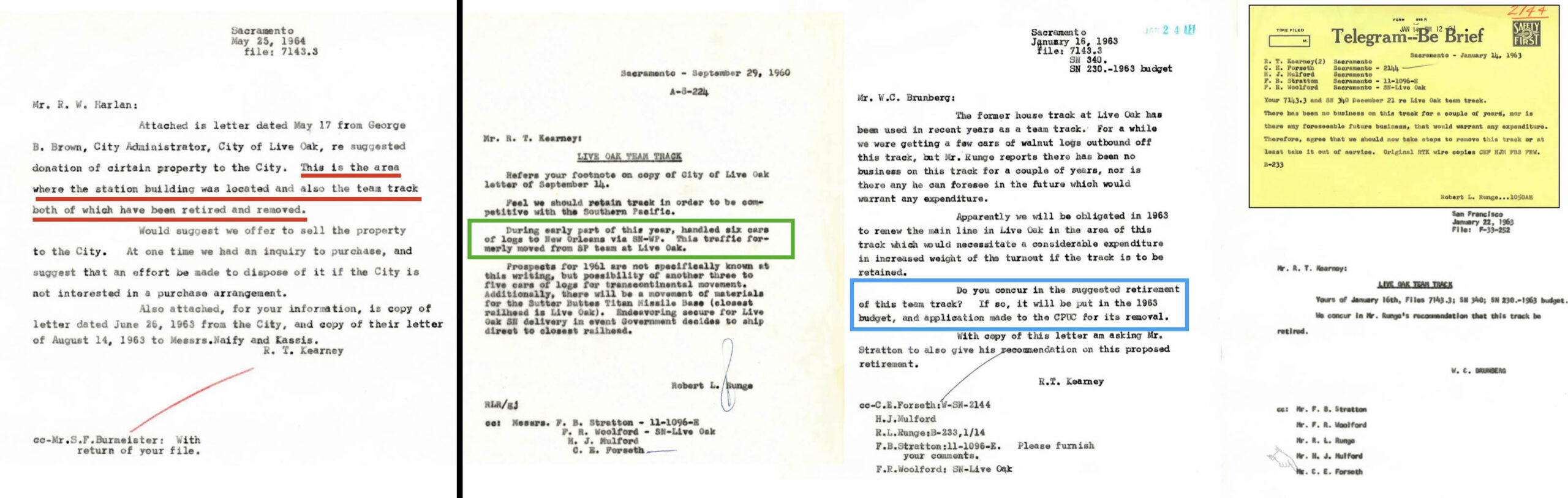
The land where the depot and team track had been located is owned and used for parking by the adjacent Church of the Nazarene in 2025. The document on the far left indicates the SN was responsible for removing both entities by 1964, red underline. It has not been determined if the City of Live Oak ever owned the property. The document to the right indicates the team track had been used at least as late as 1960, boxed in green. The documents to the right document the exchange between SN President and General Manager Rex Kearny and his team.
L322-146-Courtesy BAERA, Western Railway Museum Archives, 39586, l, 39582, three others, (Image 34 of 56)
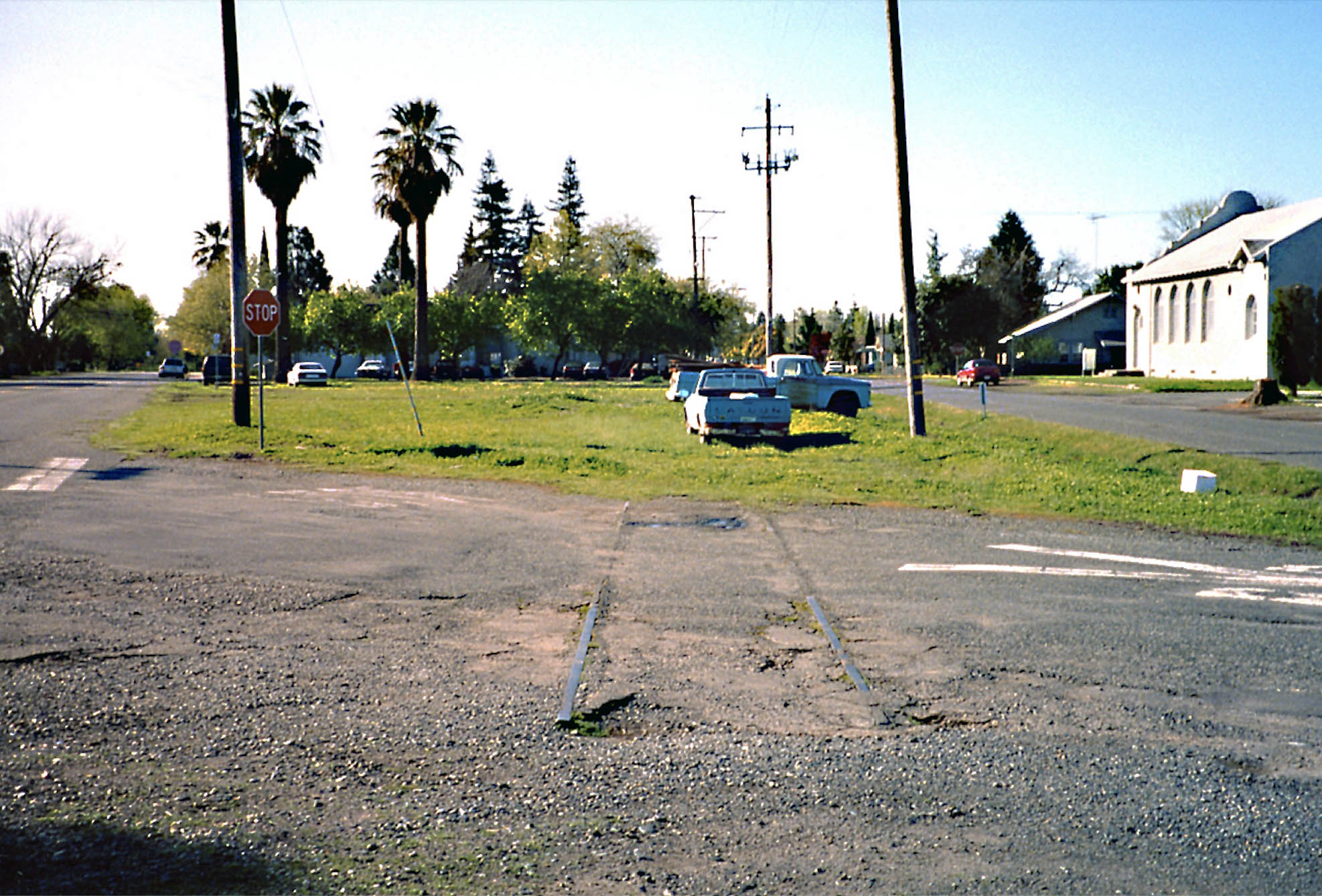
The depot spur might have been removed ca. 1963, but the rail in the asphalt from it survived into the 21st century as documented by this south view taken by Garth Groff during a reconnaissance he made to the city ca. 2005. This rail was not present in 2018, Slowly but surely, rail embedded in asphalt has been slowly disappearing between Live Oak and Peachton, particularly of note at East Gridley.
L322-147-Garth Groff Photo, Courtesy Garth Groff, (Image 35 of 56)
To complete the adjacent SP facilities, this three panel Sanborn map comparison shows the facilities up to 1921. It appears the warehouses were locally owned. The maps suggest the depot was moved south by 1914, but that could not be confirmed as with later move that will be addressed shortly.
L322-150-Courtesy Library of Congress, Geography and Map Division, Sanborn Maps Collection, (Image 36 of 56)
The two main warehouses placed alongside the SP and the depot are shown here in a south view from Mar. 7, 1958.
L322-155-Copyright California Department of Transportation, 5884-1, (Image 37 of 56)
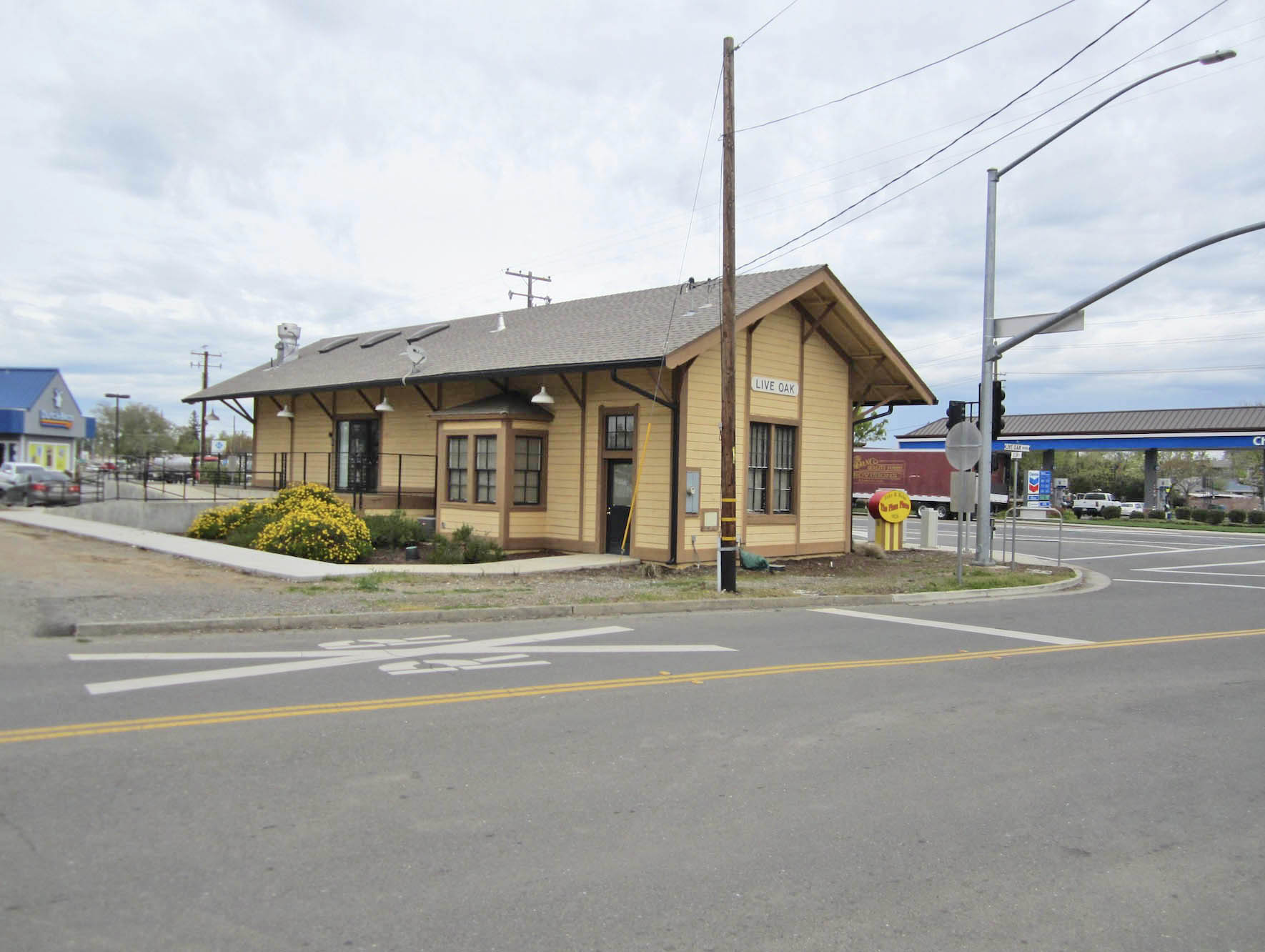
Finally to the SP Live Oak depot, here shown with SP 4469 westbound with train 201 in a north view from Mar. 25, 1956. According to Henry Bender’s “Southern Pacific Lines Standard-Design Depots” it was constructed in 1882 and abandoned on Oct. 30, 1959. It has served many purposes since then, but was in bad shape until the City took it over in 2005. By 2010 it was restored.
L322-160-Vic DuBrutz Photo, Courtesy BAERA, Western Railway Museum Archives, 75515sp, (Image 38 of 56)
And as seen earlier, the depot was in fact moved 50 ft. south from its original position in 2010. Northeast view, 2018.
L322-165-Stuart Swiedler Photo, (Image 39 of 56)
The whole area covered from Pennington Rd. south to Elm St. is shown in an east view from May 23, 1973. Note that one of the two warehouses along the SP line is since removed, red arrow.
L322-170-Copyright California Department of Transportation, 18734, (Image 40 of 56)
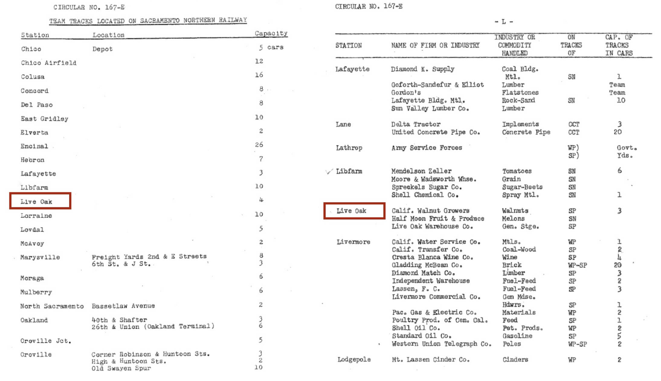
After this long review of the freight-associated structures in Live Oak, the WP Circular No. 167-E ca. 1957 indicates very modest business for the railroads. The SN Employee Timetable no. 20 Apr. 23, 1939 lists spurs with 22 and 26 freight car capacities, respectively. One for sure was along the warehouses, the second either the team track to the depot or the freight capacity of the runaround track. This has not been determined.
L322-175-Courtesy Bruce Eldridge, (Image 41 of 56)
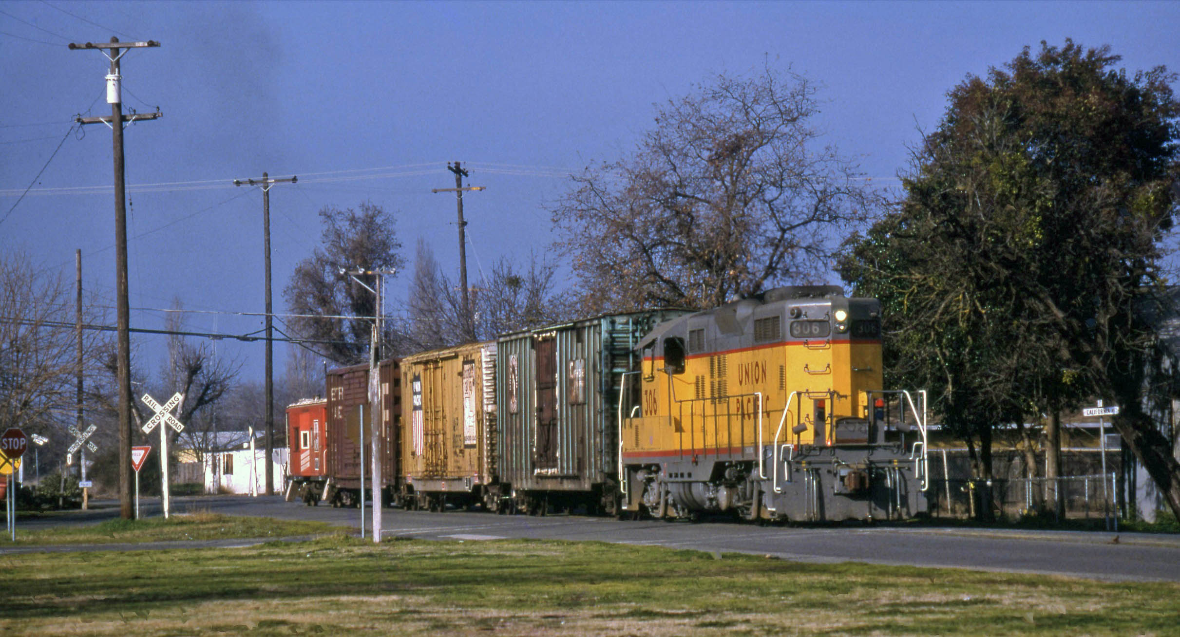
Next, a series of images taken by Tom Messer and Wayne Monger of the Chico Local showing freights on the asphalt ca. 1980. Shown here, a north view of the Local being led by Union Pacific, UP, 306 on California St. between and Fir and Gum Sts.
L322-180-Wayne Monger Photo, Courtesy Wayne Monger, (Image 42 of 56)
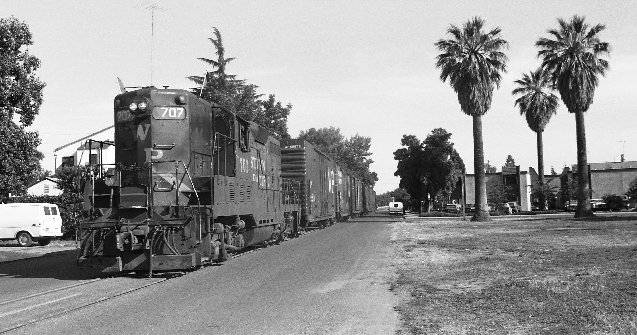
Western Pacific 707 and freight block the Firs St. intersection in this south view ca. 1980.
L322-185-Wayne Monger Photo, Courtesy Wayne Monger, (Image 43 of 56)
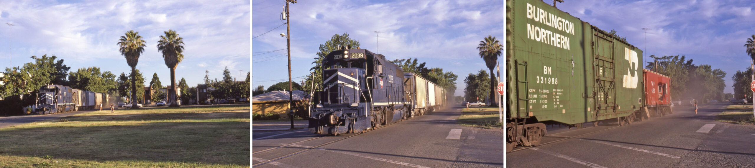
This sequence of three south views also on California St. between and Fir and Gum Sts. with Missouri Pacific, MP, 2039 had to have occurred after the merger with the UP in 1982, probably closer to the end of the Chico Local in 1985. The multi-panel display points out the trail of dust these trains left on these short sections of city streets.
L322-190-Tom Messer Photos, Courtesy Wayne Monger, (Image 44 of 56)
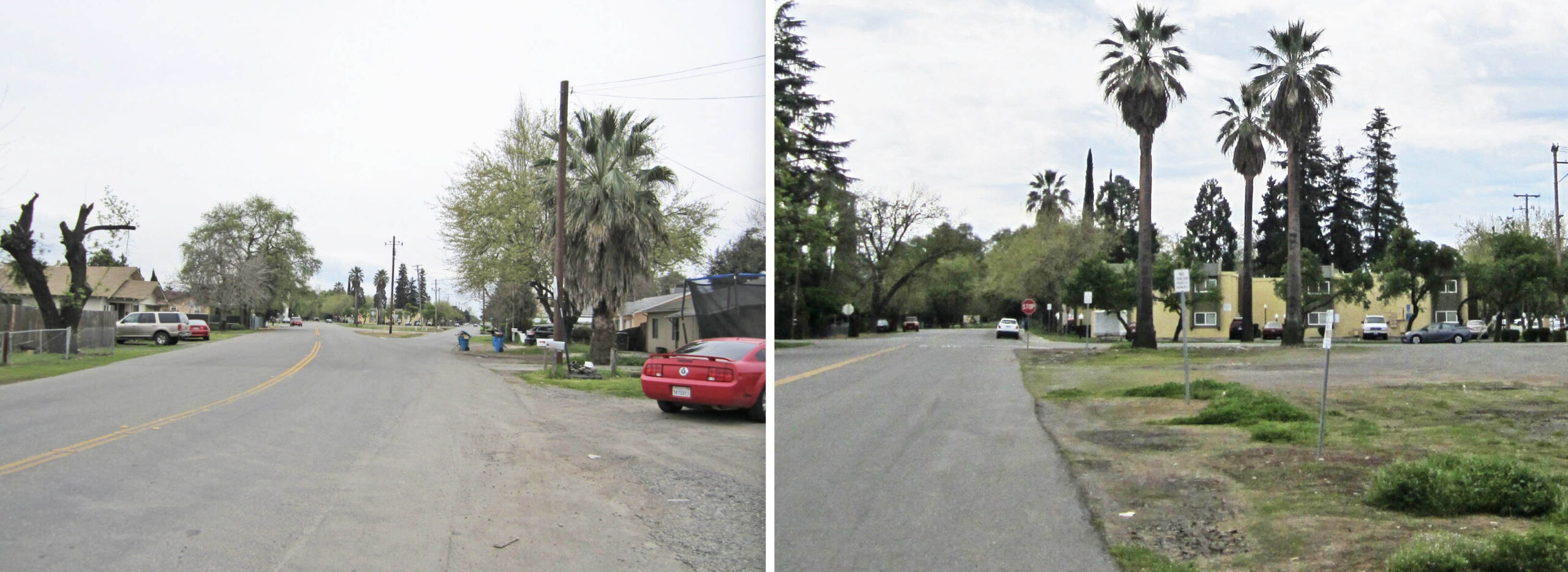
Back to the walk of 2018, having crossed Pennington Rd. heading south, the first intersection is Gum St., left, and the second one is at Fir St. with those ever-present three palm trees marking the previous site of the depot.
L322-195-Stuart Swiedler Photos, (Image 45 of 56)
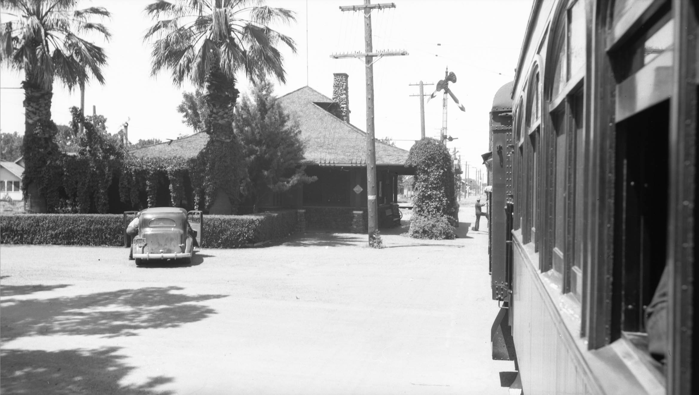
Past Fir St. the next intersection heading south is Elm St., the scene in 2018 indicates a green path ahead, left. On the right, what Howard Wolfe photographed from the rear of SN 225, used here as a closed observation car, leased and chartered on Train 11 on June 2, 1940. The hotel on the right is the Cottage Hotel, present in the 1921 Sanborn map with its dining room and kitchen for guests’ meals. Beyond that is the southern-most City Limit sign, and then a switch for the runaround track, and third rail. Also, Elm St. was Marian St. in the early 20th century.
L322-200-Stuart Swiedler Photo, l, Wolfe Courtesy BAERA, Western Railway Museum Archives, 238473sn, r, (Image 46 of 56)
Ken Meeker’s photograph of the same Elm St. intersection with SN 711 leading the Local heading north does not clearly show that spur switch. Hard to tell from this image.
L322-205-Kenneth J. Meeker Photo, Courtesy Feather River Rail Society, (Image 47 of 56)
This brings the review to the section south of Elm St., a comparison of 1941 to 2024 shown here. The aerial from 1941 shows a warehouse or barn, yellow box. Around the structure are many paths, it cannot be ascertained if there are any with train tracks. There is SN double-track alongside it as expected, but the presence of a spur to this area is equivocal. With only one freight a day, this runaround track obviated the need to build a second one planned near the SN-SP crossing. Appreciation to R.J. Dial for pointing out that the main warehouse is still around in 2025, red arrow.
L322-210-c-7490_419, Courtesy of UCSB Library Geospatial Collection, top, Google Earth, bottom, (Image 48 of 56)
Almost two decades later, the north view from Mar. 7, 1958 shows no additional track to this building.
L322-215-Copyright California Department of Transportation, 5884-2, (Image 49 of 56)
The south view from the same 1958 date adds no additional information, but is shown for completeness. Although nothing could be uncovered about that structure, its presence allowed the following two ground images to be assigned to this section of tracks.
L322-220-Copyright California Department of Transportation, 5884-1, (Image 50 of 56)
The double track section to the south of Live Oak had been called Maceta in the 1910s NE Employee Timetables up until No. 8 dated Sept. 20th, 1925. From the table shown here, the double-track section clearly served to accommodate freight in addition to servicing as a passenger stop. The image in the center is viewed to the south from the western passing or team track with a train on the mainline, while the right image shows the view to the north toward Live Oak taken on the mainline track with traffic on on the team track, both photos from 1921.
L322-222-Courtesy BAERA, Westerm Railway Museu,m Archives, 13454sn, l, 257785sn, c, 257786sn, r, (Image 51 of 56)
Here the runaround track allows SN 1009 to pass a possible excursion or special events train, that being surmised by the presence of Bay Area Electric Railroad members Addison Laflin, left, and Insley Brain, center behind the child, on the rear of the parlor car. The structure on the left is the building seen in the last couple of aerial images.
L322-225-Courtesy BAERA, Western Railway Museum Archives, 240229sn, (Image 52 of 56)
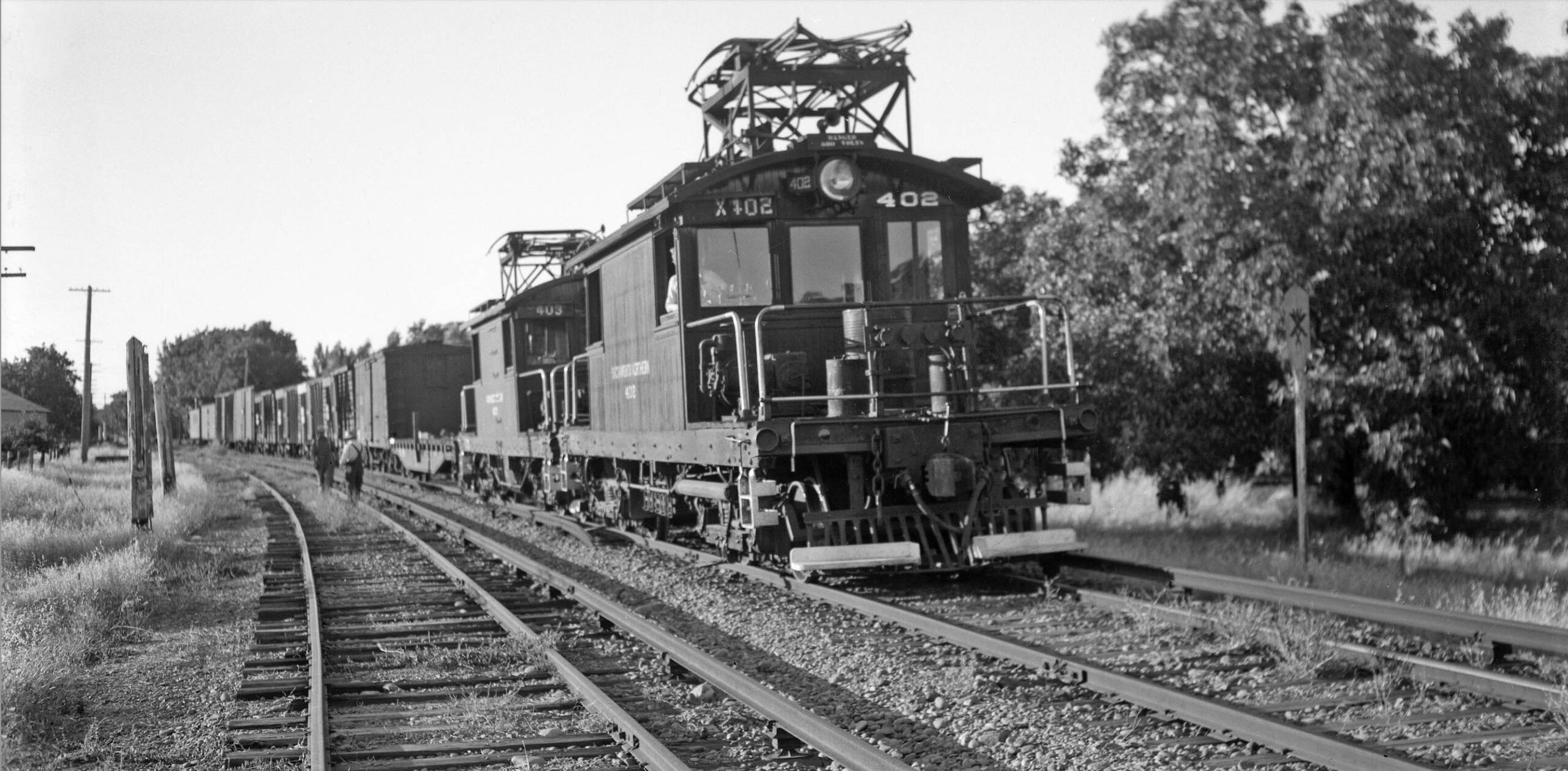
Another rare shot, Arthur Lloyd went out and took several freight images on the North End near the end of the electric era that were unique, such as this north view on the runaround track section with SN 402 and 403 on June 27, 1945. Again, the structure of interest marks the placement of this image.
L322-230-Arthur Lloyd Photo, Courtesy BAERA, Western Railway Museum Archives, 129781sn, (Image 53 of 56)
An east view from May, 23, 1973 of the runaround track section is presented here to emphasize the agricultural emphasis of this area back then. In 2025 this whole section is developed.
L322-235-Copyright California Department of Transportation, 18734, (Image 54 of 56)
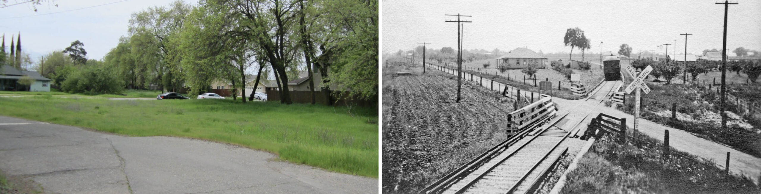
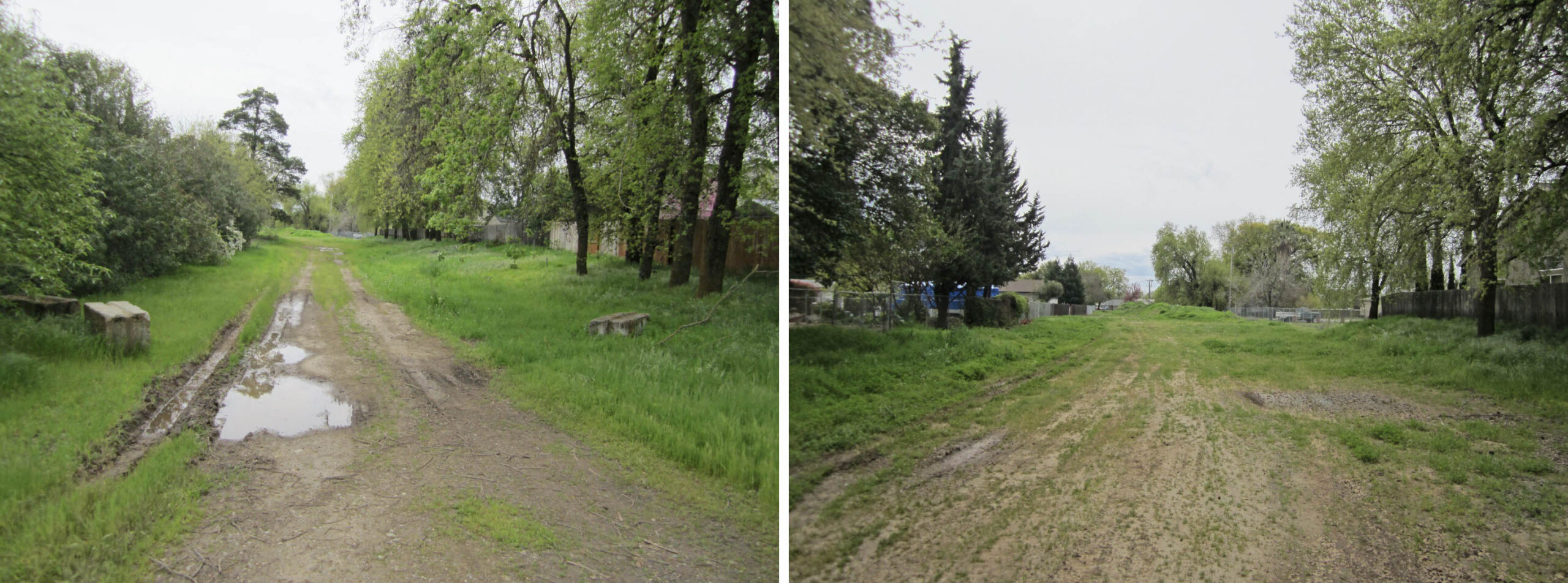
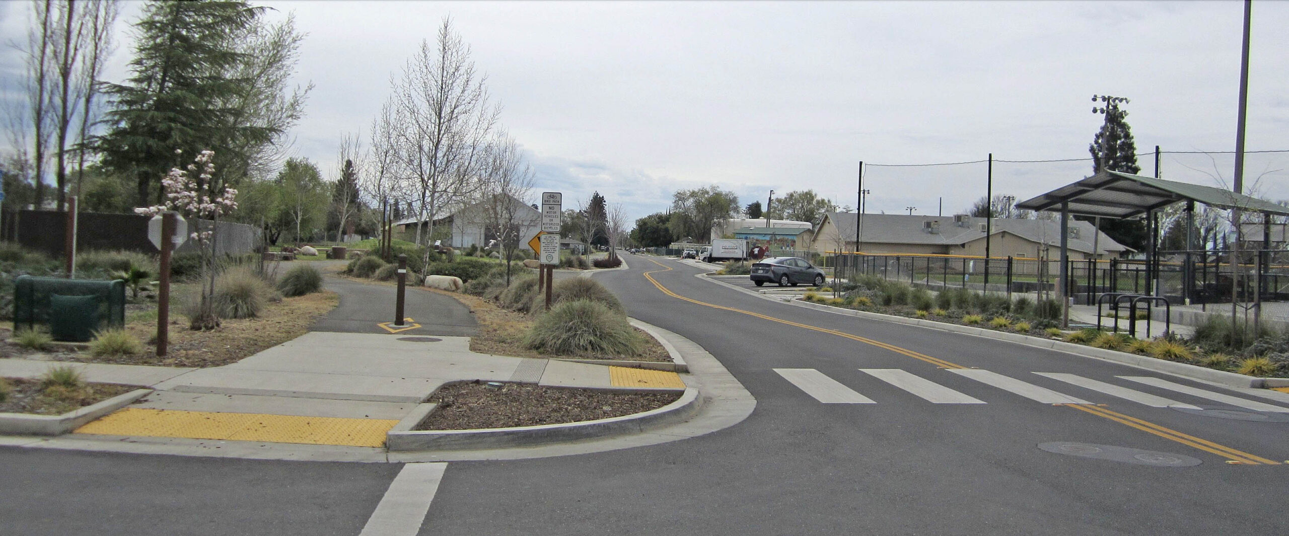
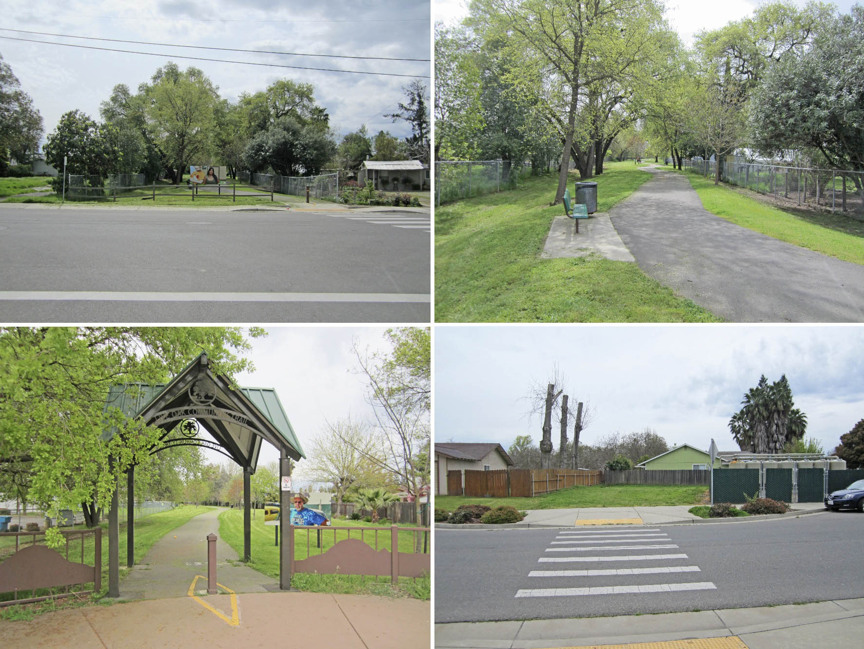
Back to the walk in 2018, on reaching Elm St., the abandoned right-of-way that contained the mainline and runaround track has been transformed to the Live Oak Community Trail. The entry from Elm St. is in the upper left, within the trail viewed to the south is seen in the upper right. The entry from the southern end at Apricot St. viewed to the north is shown in the bottom left, and what exists across Apricot St. viewed to the south is seen in the bottom right. Interesting that part of the right-of-way remains open for a few yards in the latter image.
L322-240-Stuart Swiedler Photos, (Image 55 of 56)
To finish up, a south view from Mar. 7, 1958 showing what was then the transition at the southern end of Live Oak from private houses to farms. Note the SP right-of-way, Larkin Rd., and the SN right-of-way, left to right, respectively, seen all the way south to what is Clark Rd. in 2025. Appreciation to Wayne Monger and Tom Messer for their images at Live Oak, to Garth Groff for sharing his images and his research of the SN in Live Oak and the proposed line to Pennington, and to R.J. Dial for historical information on structures along the SN right-of-way.
L322-245-Copyright California Department of Transportation, 5884-1, (Image 56 of 56)