Transformation of the Linden Street Corridor at the Emeryville-Oakland Border, Part 1, Tower 3 to 45th Street
The completion of the transformation of Linden St. from an interurban railway-industrial corridor to a high density residential enclave occurred during the first two decades of the 21st century. This update will begin a journey back in time to reconstruct the timeline of these changes, and to provide a 20th century context to the images shown here.
L275-05-Stuart Swiedler Photos, (Image 1 of 34)

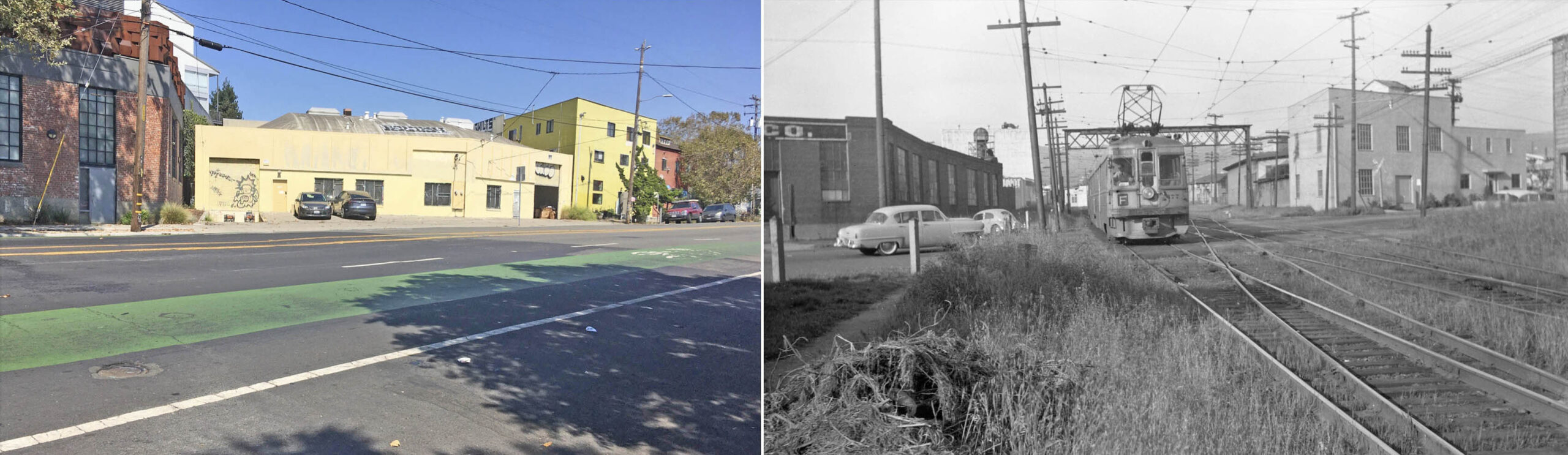
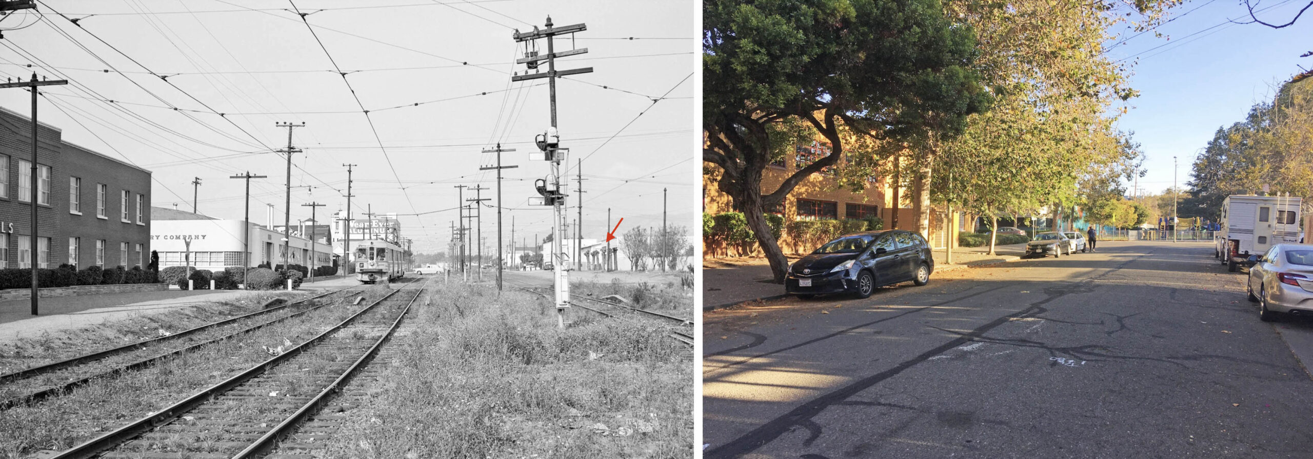
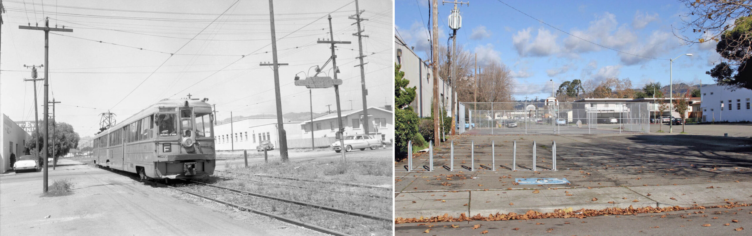
The northeast view in the left panel from 2022 shows an odd shaped building on 40th St. between Adeline St. and Linden St. at the Emeryville-Oakland border. Shoehorned between two structures from the early 20th century, the space became available when the Key System abandoned its private right-of-way, herein referred to as “the cut”, in Apr. 1958, soon after the image on the right with KS 177, F line, was taken at the same spot.
L275-10-Roy Covert Photo, Courtesy BAERA, W. Railway Museum Arch., 96251ks, and Stuart Swiedler Pht., (Image 2 of 34)
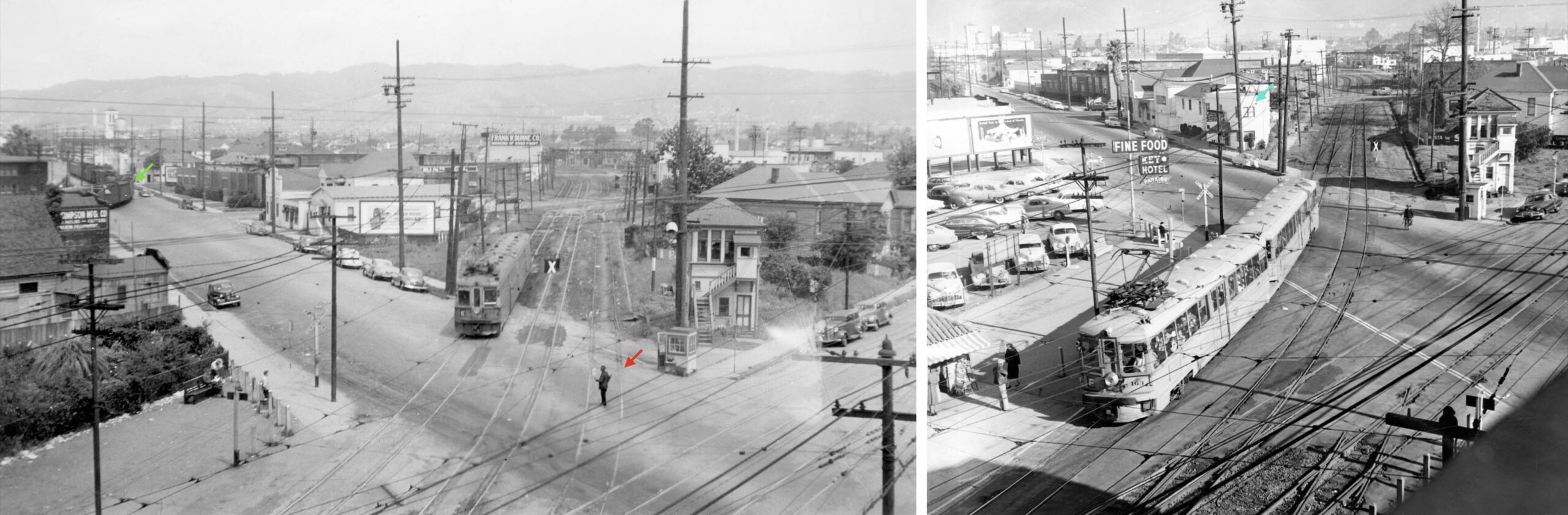
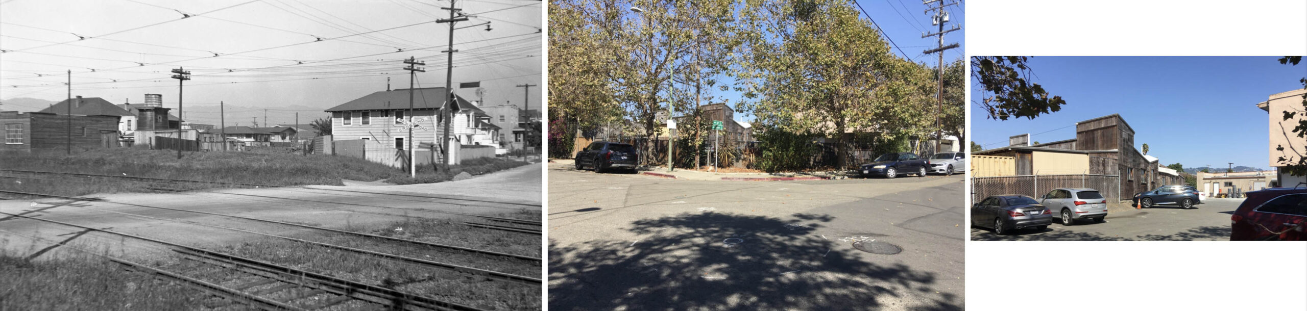
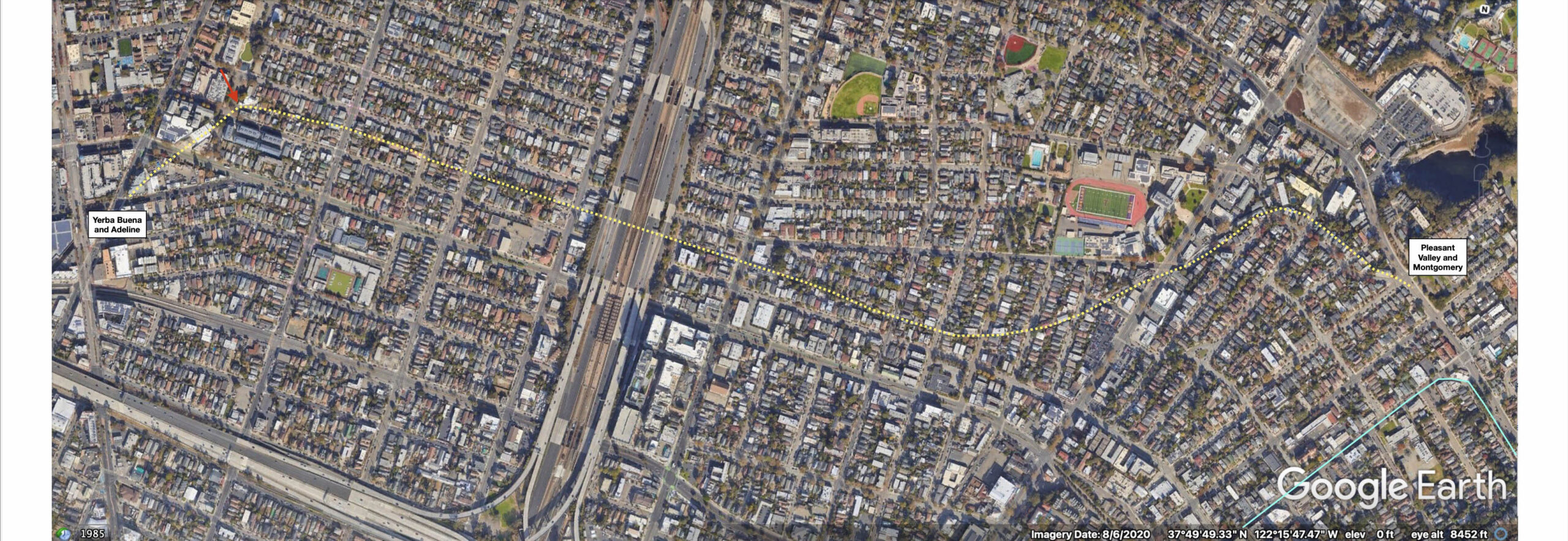
The area to be reviewed is seen on the left in a north view from Apr. 8, 1953. An enlarged view on the right shows the cut from Tower 3 at Adeline St. and Yerba Buena Ave., red arrow, to the position of the since removed Tower 4, yellow dot, and the area where the three interurban lines dispersed, orange arc.
L275-15-Copyright California Department of Transportation, 3300-6, (Image 3 of 34)
Further details from the previous image, right, and a matching southwest view, also from Apr. 8, 1953, left, mark Tower 3, labeled no. 1, and two structures, no. 2 and no. 3.
L275-20-Copyright California Department of Transportation, 3300-4, l, 3300-6, r, (Image 4 of 34)
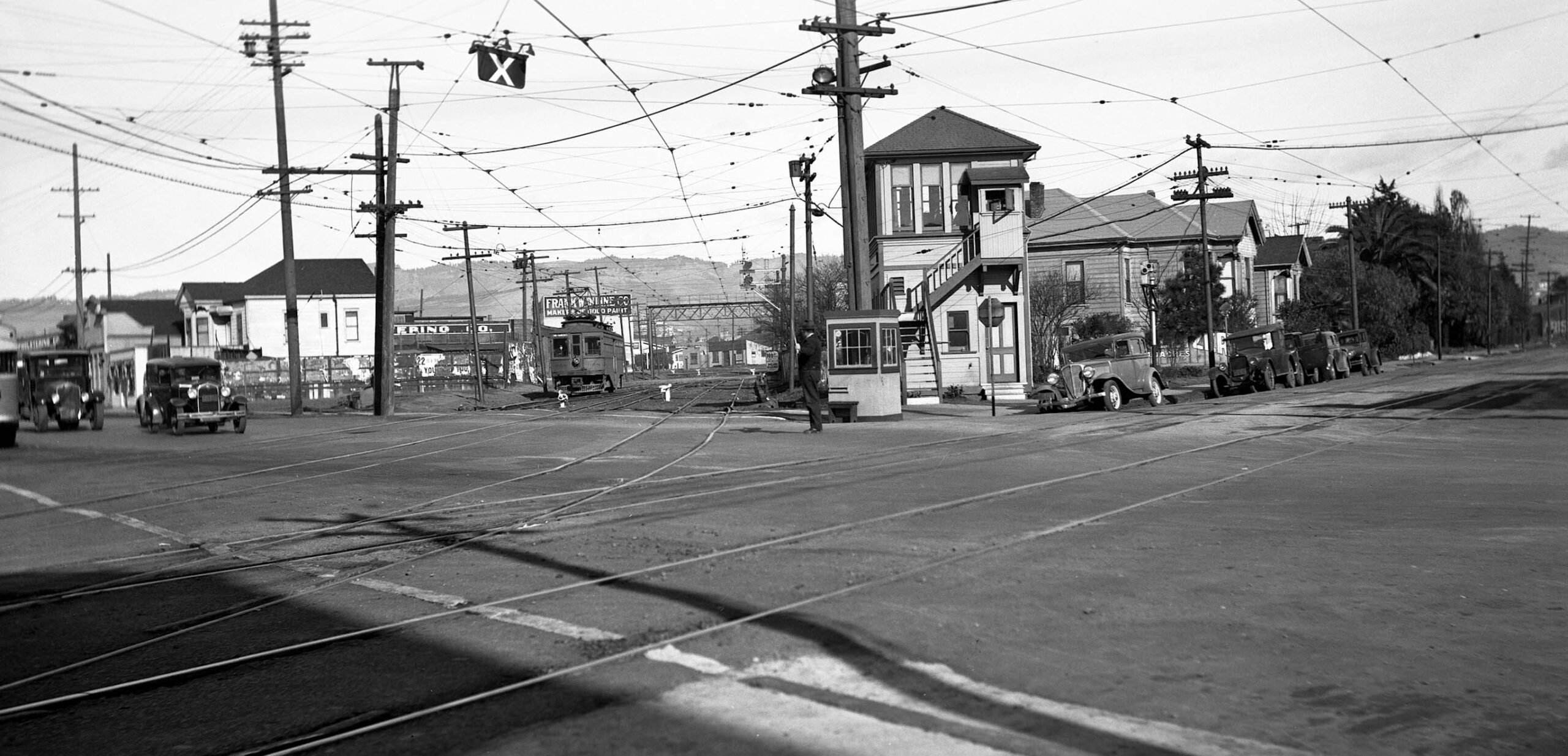
According to Harre Demoro’s “The Key Route”, interlocking Tower 3 was operational at the northeast corner of Yerba Buena Ave., then Spring St., and Adeline St. on May 11, 1910, left panel, to handle the Berkeley and Claremont lines, and in anticipation of the addition of the Northbrae line at the end of 1911. The tower would oversee up to 18 Key trains per hour into the cut, 6 more per hour along Yerba Buena Ave., plus less frequent Sacramento Northern passenger trains and Oakland Terminal freights. The image on the right from 1922 reveals other architectural features of the housing along Yerba Buena Ave., three-story condos in their place in 2022.
L275-25-Courtesy BAERA, Western Railway Museum Archives, 175252ks, and John Harder Collection, (Image 5 of 34)
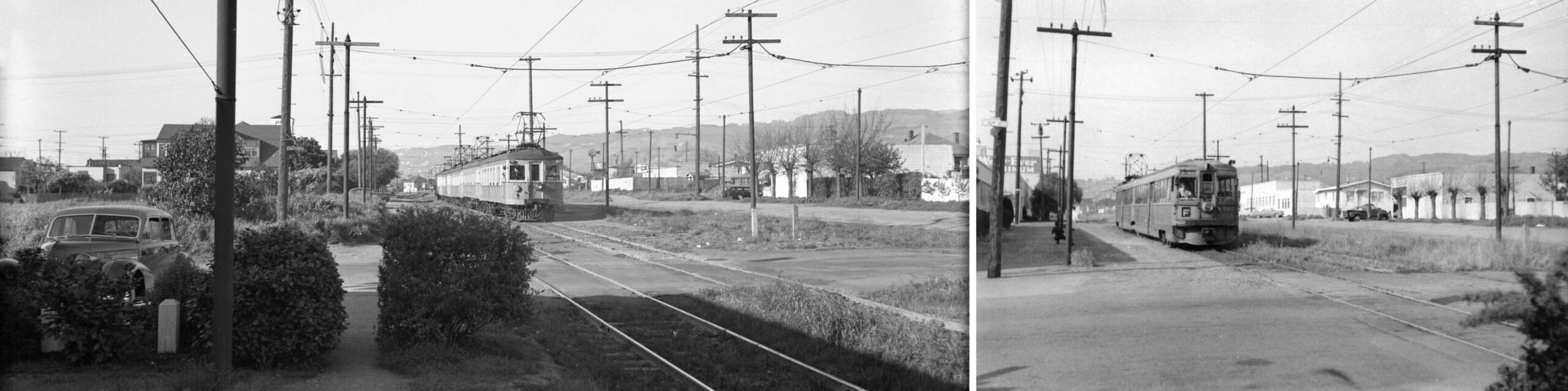
A Feb. 1936 northeast view of the cut by Ralph Demoro from the southwest corner of Adeline St. and Yerba Buena Ave. with approaching KS 658 under the watchful eyes of the tower and flagman begins the process of noting changes to the area. Images of the cut prior to interurban use of the Bay Bridge marked by its author with a date are rare.
L275-28-Ralph Demoro Photo, Courtesy John Harder, (Image 6 of 34)
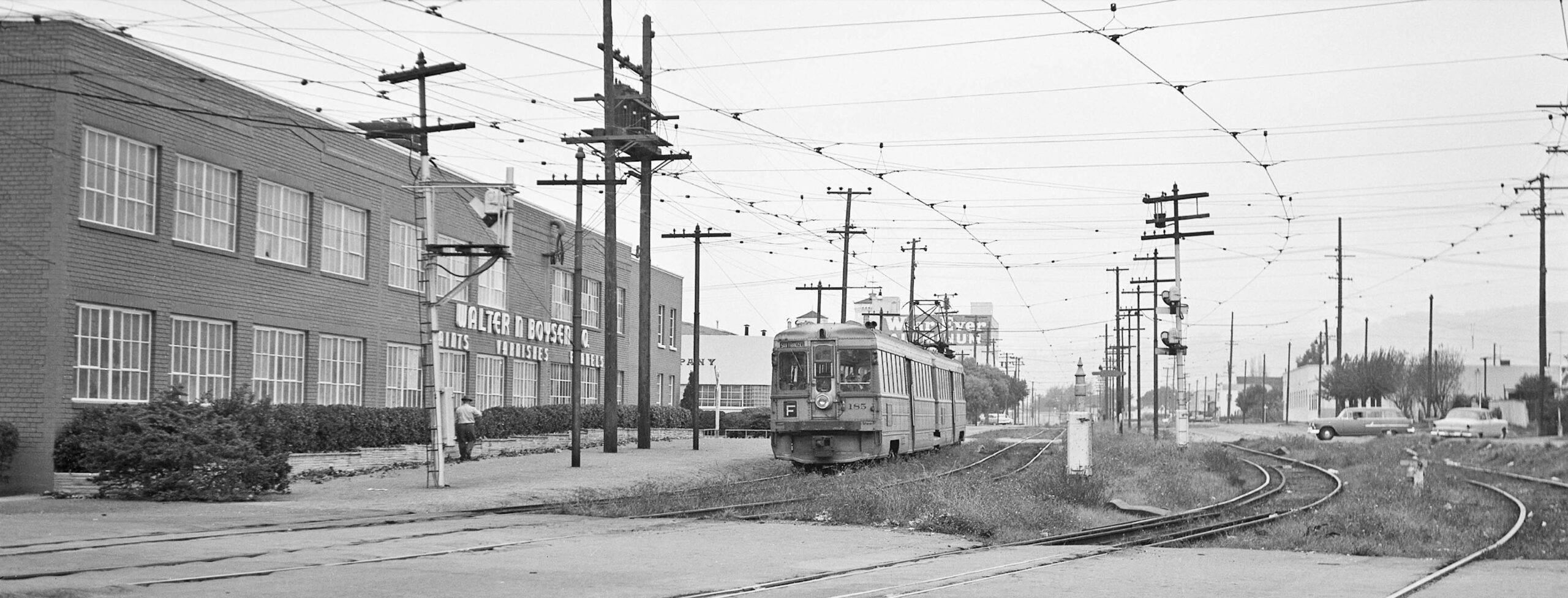
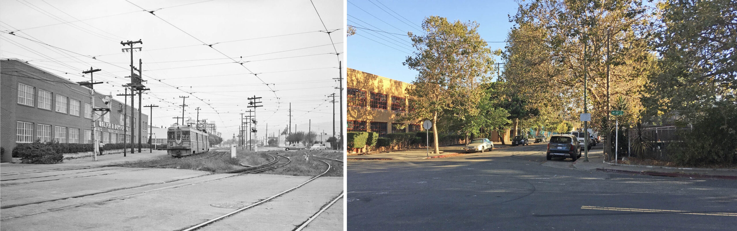
The mid-1940s northeast view on the left from the Ritz Hotel across from the cut shows three tracks on its entry, the one marked with a red arrow to be eliminated by the time the image on the right was taken in the mid-1950s. The left image also shows a Santa Fe freight, green arrow, turning off Adeline St. to that company’s depot and yard. The structure on Adeline St. marked by the turquoise arrow in the right image by Don Sims, labeled no. 2 in L275-20, was added during the interval these images were taken. Ref: Moreau Collection, right
L275-30-Courtesy BAERA, Western Railway Museum Archives, 20550ks, l, Don Sims Photo, 160523ks, r, (Image 7 of 34)
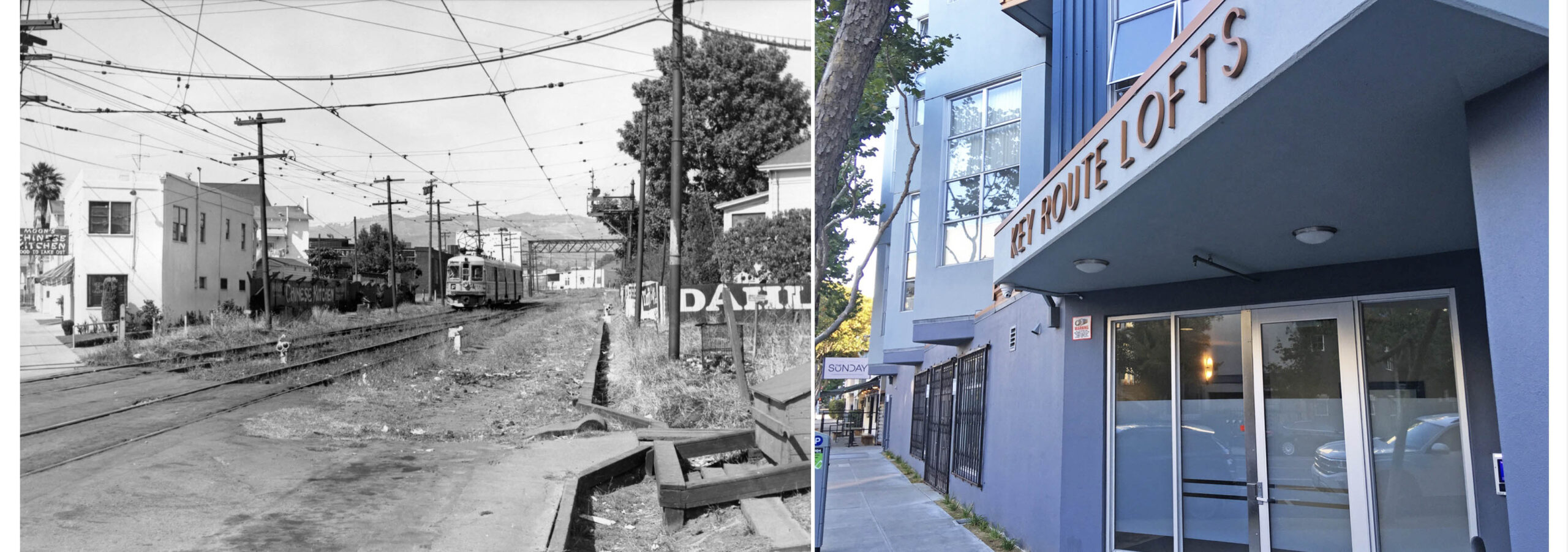
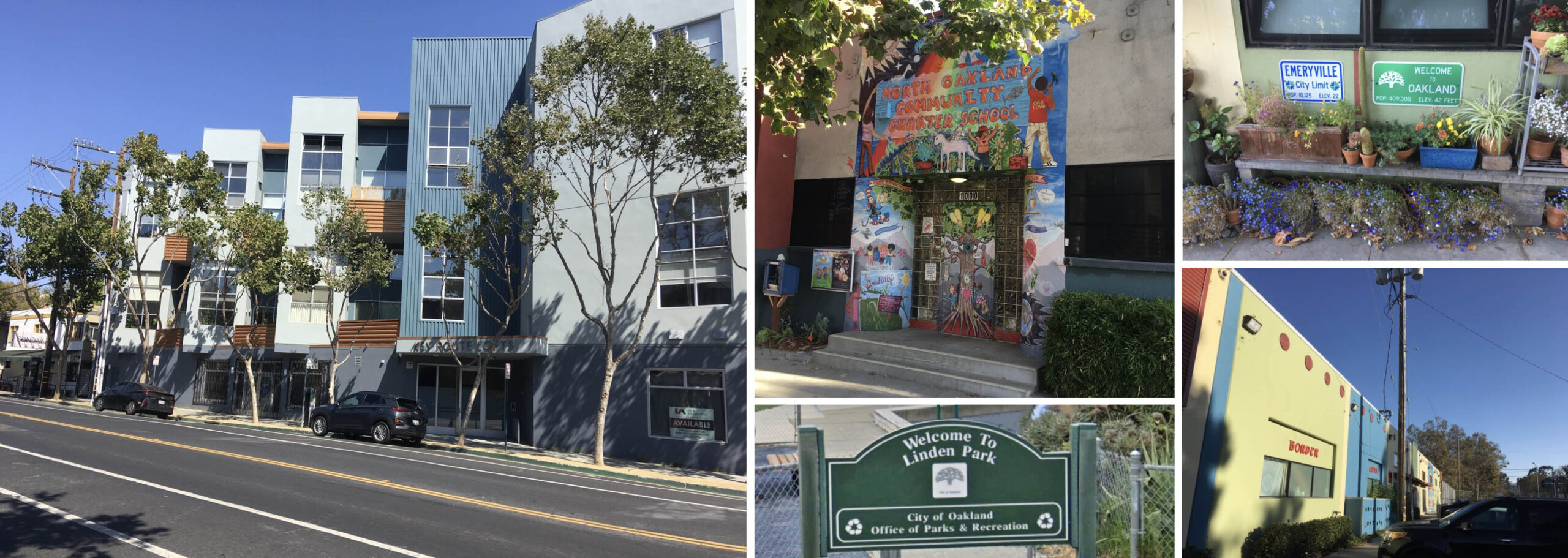
The cut was a popular place for billboards to catch the eye of passengers. The Nov. 1954 northeast view of KS 171, F line, by Harre Demoro on the left documents the close proximity of Moon’s Kitchen, labeled no. 2 earlier, to its ad in the cut. Built in 2005, the Key Route Lofts occupy all the land previously occupied by the tower and the cut, right, and a sign at the site of the former restaurant indicates a new business starting in late 2022. Note in the left image, the third Key track is completely removed in the cut, but the overhead wire and signal remains.
L275-35-Harre Demoro Photo, Courtesy BAERA, W. Railway Museum Arch., 189866ks, l, Stuart Swiedler Photo, r, (Image 8 of 34)
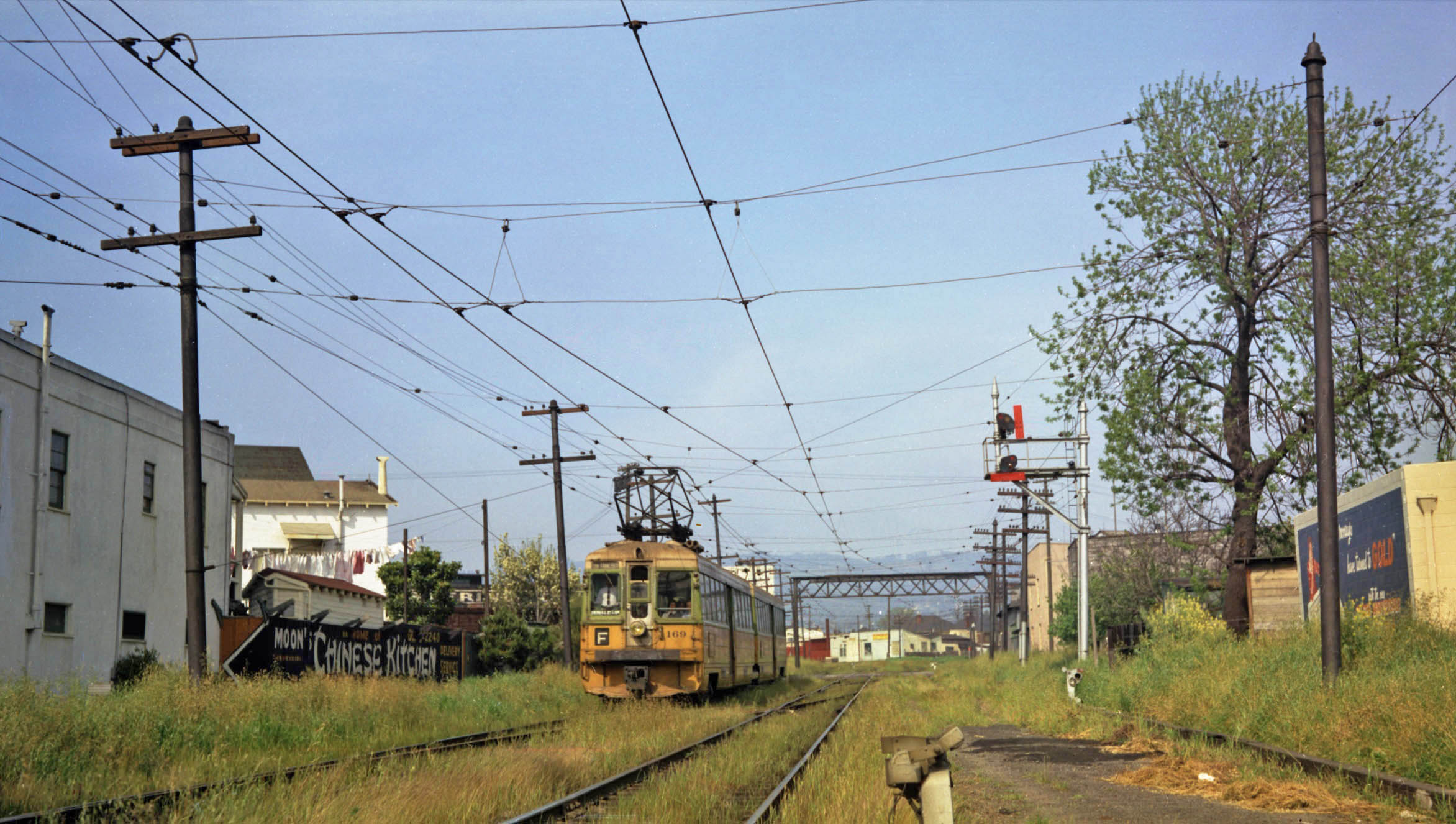
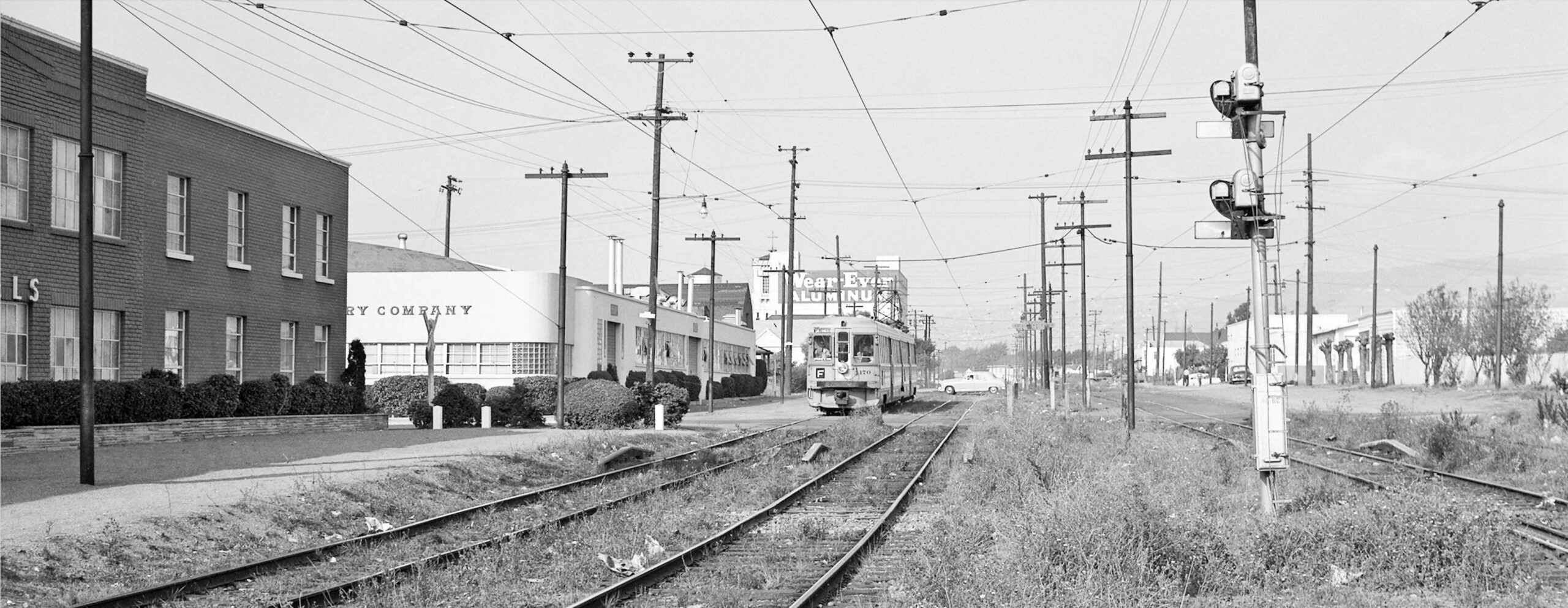
A similar northeast view from 1957 with KS 169, F line, just to document the vibrant colors of the cut.
L275-40-Key Official Photo, Sappers Coll., Courtesy BAERA, Western Railway Museum Archives, 85728ks, (Image 9 of 34)
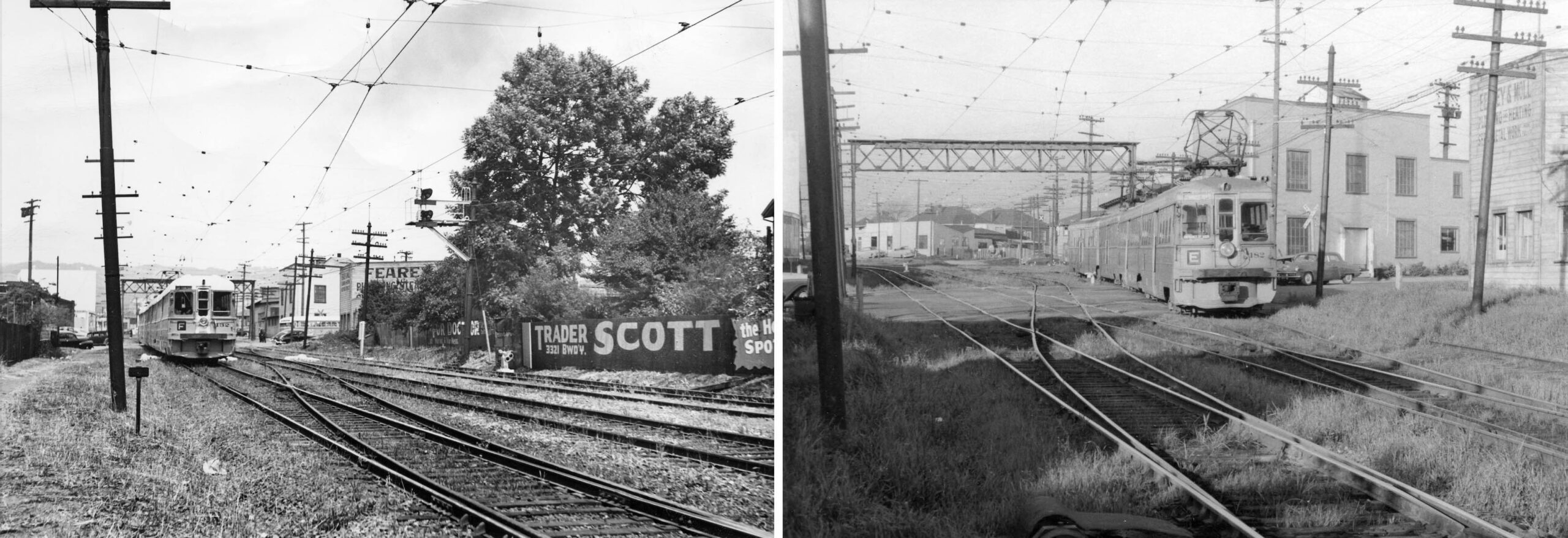
The building on the southeast corner of the 40th St. intersection labeled no. 3 is seen in two northeast views, from ca. 1950 with KS 132, F line, left, and mid-1950s with KS 182, E line, right. Together, the building sign reads Feary and Moll Plumbing and Heating. Two Fearys were in the area in the 1910s, and this location with Moll in the 1930s, and gone from listings in the mid-1950s. Note in the left panel, a no. 57 line Key bus westbound on 40th Street waiting for a train.
L275-45-Courtesy BAERA, Western Railway Museum Archives, 160781ks, l, Harre Demoro, r, (Image 10 of 34)
Back to the north view from Apr. 8, 1953, this detail includes 40th St. along the bottom or south, to 43rd St. along the top. The brick building in Emeryville, 4000 Adeline St., starting at the corner and forming the west wall of the cut at 40th St., labeled no. 4, was occupied by National Upholsteries Co. from the mid-1930s past 1967. Several businesses occupy this building in 2022, and the cut is filled with buildings between 40th and 41st Sts.
L275-50-Copyright California Department of Transportation, 3300-6 Detail, (Image 11 of 34)
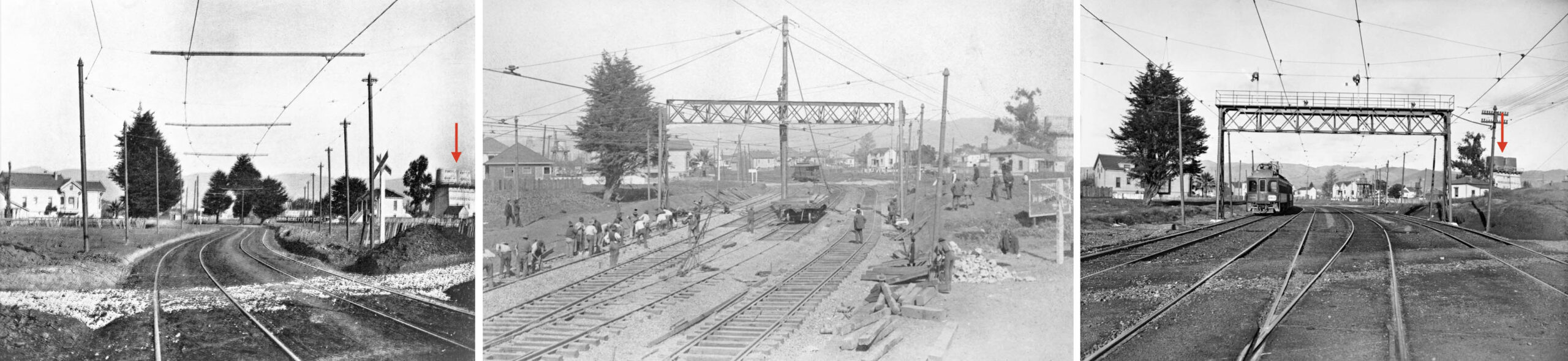
Three northeast images from 40th St. show the early evolution of the cut. None are dated, but the one to the left was probably close to the first train through the cut, Oct. 26, 1903. The signal tower was completed in Feb. 1911, center, while the image on the right, based on the trees, must be several years later. Haselbacher’s Nursery, red arrow, occupied most of 41st St. east of Linden St. The 1902 Sanborn map indicates that there were two houses between 41st-42nd Sts. on the west side, and one house next to the nursery on the east side.
L275-55-Courtesy BAERA, W. Railway Museum Arch., 82623ks, l, 189869k, m, 32452ks, r, (Image 12 of 34)
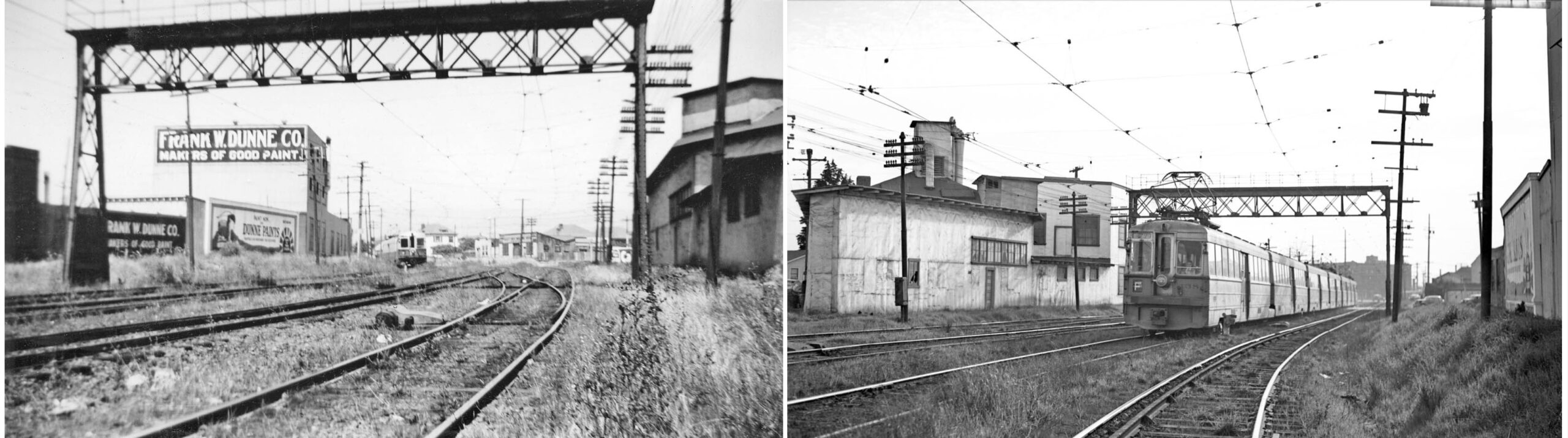
North of 4000 Adeline St. on the west side of the cut up to 41st St. was Frank Dunne’s paint company, labeled no. 6 in L275-50, seen in the northeast view on the left of KS 145, F line, from Aug. 4, 1942. They occupied this building at 1001 41st St. from the early 1920s past 1967. The southwest image on the right of KS 138, F line, shows no. 1050 40th St., labeled no. 5, the east flank to 41st St., occupied by Pacific Graphite Works during the same period. American Foundry Equipment and Wyodak Chemical Co. occupied some of this space when this image was taken in the early 1940s.
L275-60-Courtesy BAERA, W. Railway Museum Arch., Peter Khyn Photo, 128534ks, l, 122347ks, r, (Image 13 of 34)
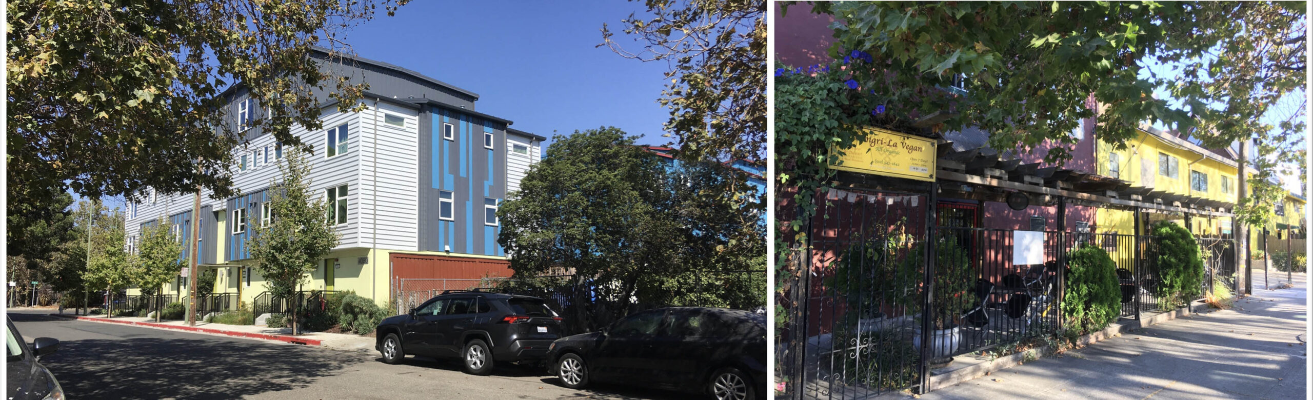
Turning north from 40th St. onto Linden St. in 2022 reveals Lowney Architects’ 41st Townhouses on the east side of Linden St., left panel, completed in 2019, replacing the area labeled no. 7 in L275-50. The west part appeared to be occupied by scrap yards in the 1953 aerial, with Acorn Linen Supply Co. and California Linen Supply Co. to the east, the lot showing delivery trucks. This was where Haselbacher’s Nursery had been. On the west side, right panel, no. 5 is the east side of 1050 40th St., this side not facing the cut.
L275-65-Stuart Swiedler Photos, (Image 14 of 34)
Continuing north on the west side of Linden St. in 2022 past 1050 40th St. shows the curved building occupying the ex-cut serving light industry. Behind it are towers and a fire escape, left panel, the building replacing the razed Dunne Co., no. 6 in L275-50. This is 1007 41st St., Swatt-Miers Architects’ Green City Lofts, completed in 2005. The developers were given a variance to exceed the height limits in Emeryville and Oakland of 30 ft. and 65 ft., respectively. Split in half by the two cities, their innovative “green” design retains a 30 ft. eave line to align with neighborhood buildings, but gaining height as it steps back from the street.
L275-70-Stuart Swiedler Photos, (Image 15 of 34)
The left panel shows a northeast view across the four tracks circa early 1930s of the northeast corner of Linden St. and 41st St. The open space, labeled no. 8 in L275-50, can still be appreciated in 2022, middle and right panels. Small industrial buildings filled up the space to 42nd St. at 4114 Linden St. as follows: East Bay Machine Works, 1937; Sanitary Metal Products, 1944; National Painting Co. and Oakland Roofing Co., 1953; and a switch to tech in 2022, Artichoke Productions. Read on as to the significance of the space …
L275-75-Sappers Coll., Courtesy BAERA, W. Railway Museum Arch., 143859ks, l, and S. Swiedler Photos, (Image 16 of 34)
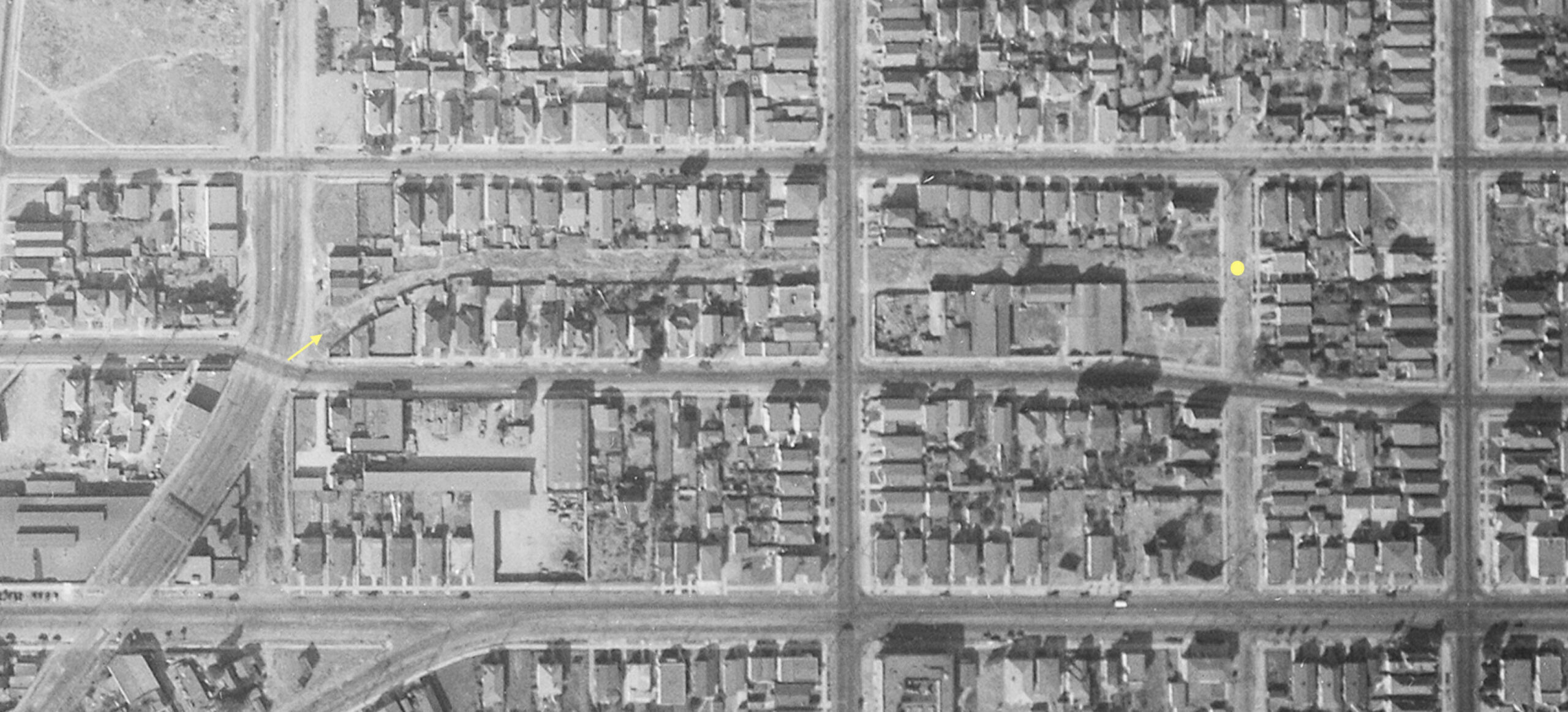
This 1931 aerial, rotated 25.5 degrees from its north orientation, shows an additional cut extending from Linden and 41st Sts., yellow arrow, to Lusk St., yellow circle. This was to serve the San Jose Short Line, a project that never materialized as Borax Smith headed to financial insolvency. Track was never laid down. The placement of the signal bridge in the cut in 1911 anticipated trains heading to San Jose via this route, as well as via the Linden St. route to Sacramento.
L275-80-c-1820 55, Courtesy of UCSB Library Geospatial Collection, (Image 17 of 34)
Indeed, much of the San Jose Short Line cut may still be traced from 41st St., red arrow, all the way to Pleasant Valley Rd., as seen superimposed as a yellow dotted line on this 2022 map. Houses built at unique angles relative to neighboring structures are the visual clue. The Key Piedmont or C line would eventually be extended in 1924 up Piedmont Ave., turquoise line, and incorporated part of the projected path of the San Jose line.
L275-85-Courtesy Google Earth, Modified by Stuart Swiedler, (Image 18 of 34)
A refresher on the progress so far from the north view from Apr. 8, 1953, the next two buildings of interest are labeled no. 9 between 41st. and 42nd Sts., and building no. 10 between 42nd and 43rd Sts.
L275-90-Copyright California Department of Transportation, 3300-6 Detail, (Image 19 of 34)
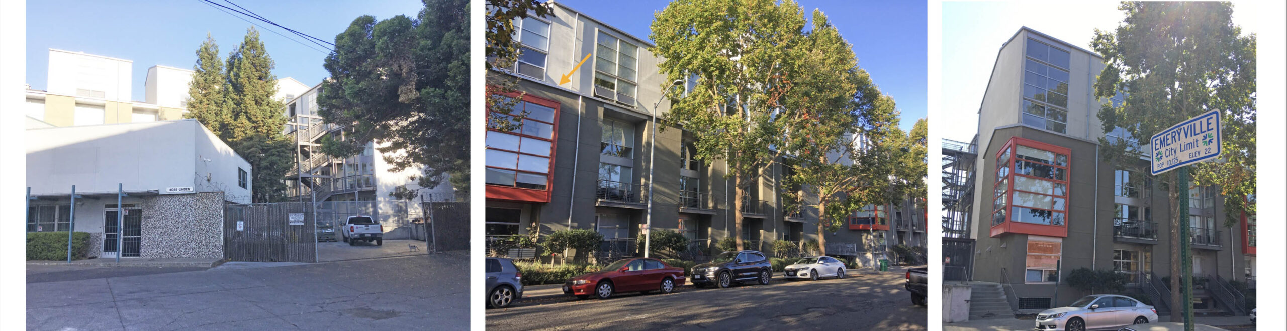
John Harder’s northeast view ca. 1953 from 41st. shows Key 185, F line, passing Walter Boysen Co., another paint-related enterprise on the west side, labeled no. 9. It was listed here from 1930 past 1967. The building is still entered at 1001 42nd St. McGrath Properties acquired the 40,000 square foot building in 1998, coordinated the cleanup of the mineral spirits contamination, and removed several underground tanks. The site is planned for conversion to up to 90 residential units leaving the brick building intact.
L275-95-John Harder Photo, Courtesy John Harder , (Image 20 of 34)
The same image placed against one from 2022 shows that little has changed about the exterior of the building. McGrath Properties uses some of the north side space, and has two tenants, Olafson Environmental, and Heart and Soul Center of Life Church. However, starting here, Linden St. only occupies the west side of the railway cut, the east side of the street now occupied by industry. More about this coming up.
L275-100-John Harder Photo, Courtesy John Harder, l, and Stuart Swiedler Photo, r, (Image 21 of 34)
Another John Harder image from the early 1950s, here at 42nd St. with a northeast view of KS 170, F line, as it passes the building labeled no. 10, only a partial name of a company in view. In 1953, the partial name matches Hobbs Battery Co., who occupied the space, followed in time by a plastic limb manufacturer, until the building went vacant by 1967. It is now occupied by North Oakland Community Charter School, NOCCS, 1000 42nd St, a public K-8 charter school founded in 2000.
L275-105-John Harder Photo, Courtesy John Harder, (Image 22 of 34)
The same early 1950s image placed against one from 2022 shows that the entire road is blocked off at 42nd St. at the later date. Also note the trimmed trees on the east side marked by the red arrow in the earlier image on the left, a useful marker in the images that follow.
L275-110-John Harder Photo, Courtesy John Harder, l, and Stuart Swiedler Photo, r, (Image 23 of 34)
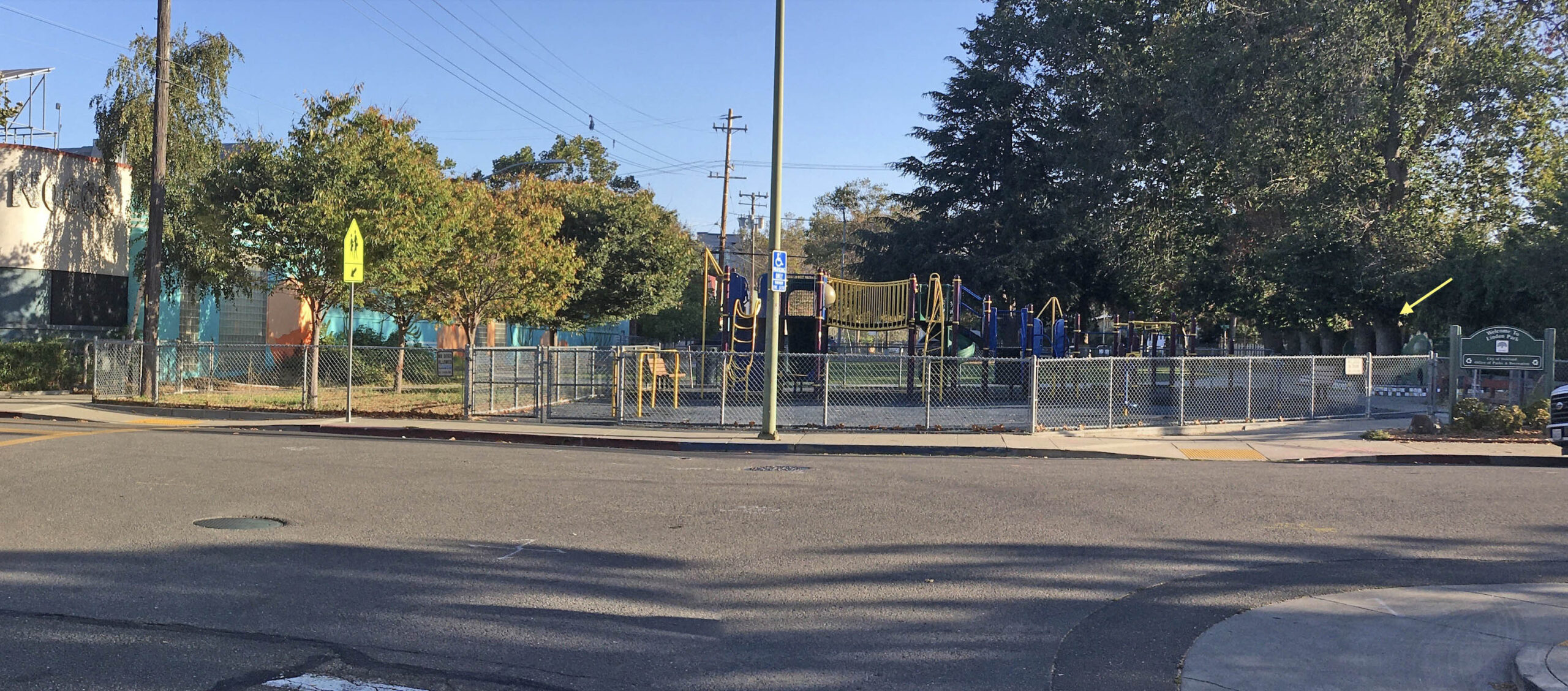
This northeast view from 42nd St. shows Linden Park, adjacent to the NOCCS, terminating the street and serving as a playground for the school. Note the trees seen in the last image are no longer trimmed, yellow arrow. This park was created sometime between 1965 and 1993 based on maps and images, but the city documents or newspaper accounts have not been found. Much evidence of related events are presented next.
L275-115-Stuart Swiedler Photo, (Image 24 of 34)
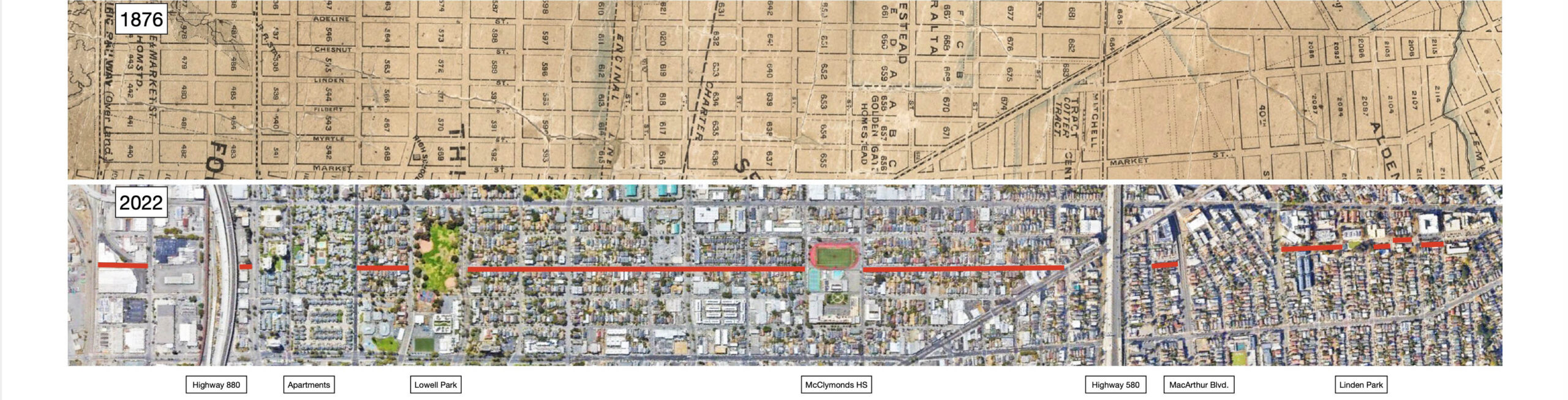
The odd layout and interruption of Linden St. in 2022 reflects Oakland ordinances beginning in 1962 and 1964, to vacation the land north of 46th St., and the eastern sections between 44th-45th Sts., and 41st St - 42nd St., respectively. The 1876 map shows Linden St. as a continuous street from West 1st and the Central Pacific tracks to Temescal Creek. In 2022, in addition to the area of study, Linden St. has endured many rounds of vacated land in the 20th century as indicated.
L275-120-David Rumsey Map Collection, David Rumsey Map Center, Stanford Libraries and Google Earth, (Image 25 of 34)
On the left, the west side between 42nd-43rd Sts. occupied by the school in 2022 was an empty lot in 1943. A house sits alone one block north. On the right, as expected for this ca. 1957 northeast view, the Hobbs Battery Co. fills the once empty lot, and there is a building in the place of the house between 43rd and 44th Sts., labeled no. 12 in the image to follow. The east side between 42nd-43rd Sts. is similar between the two images, including the trimmed trees and Deiro’s Grocery at no. 999 43rd St. between 1953 and 1967, labeled as building no. 11. That structure has since been replaced.
L275-125-Courtesy BAERA, W. Railway Museum Arch., Charles Savage Photo 8326ks, l, 189972ks, r , (Image 26 of 34)
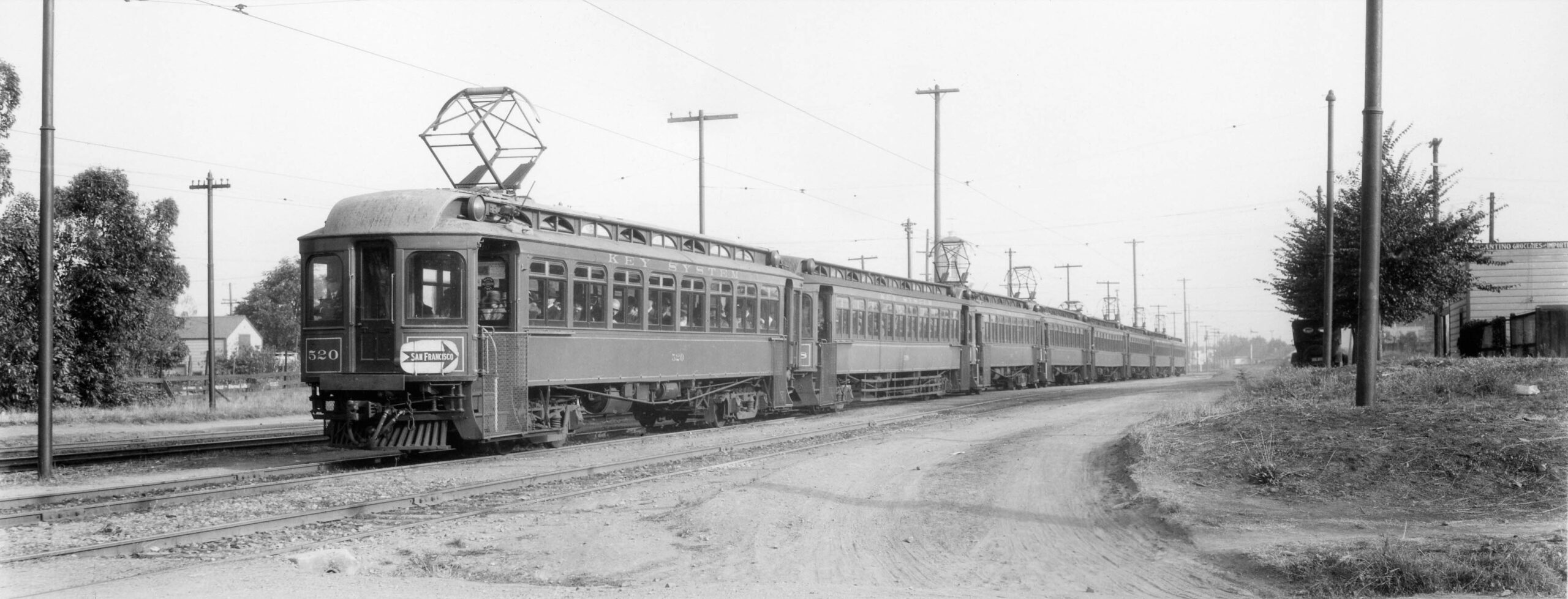
Prior to Deiro’s Grocery, from about 1918 to 1950, 999 43rd St. was Cantino Groceries and Imports, seen on the right edge of this north view of a KS 520 led eight-car Claremont train headed for San Francisco in the early 1920s.
L275-127-William E. Gardnier Photo, Estacaille Coll., Courtesy BAERA, W. Railway Museum Arch., 20563, (Image 27 of 34)
Back to the north view from Apr. 8, 1953, the house between 43rd and 44th Sts. on the west side is labelled as no. 12. The 1902 Sanborn map indicates a house at that location with an illegible address, the 1912 Sanborn with an address of nos. 4305-4307, 2 flats, the 1938 reverse telephone directory as no. 4311, and the 1953 reverse directory as 4309-4311. It was razed about 1956.
L275-130-Copyright California Department of Transportation, 3300-6 Detail, (Image 28 of 34)
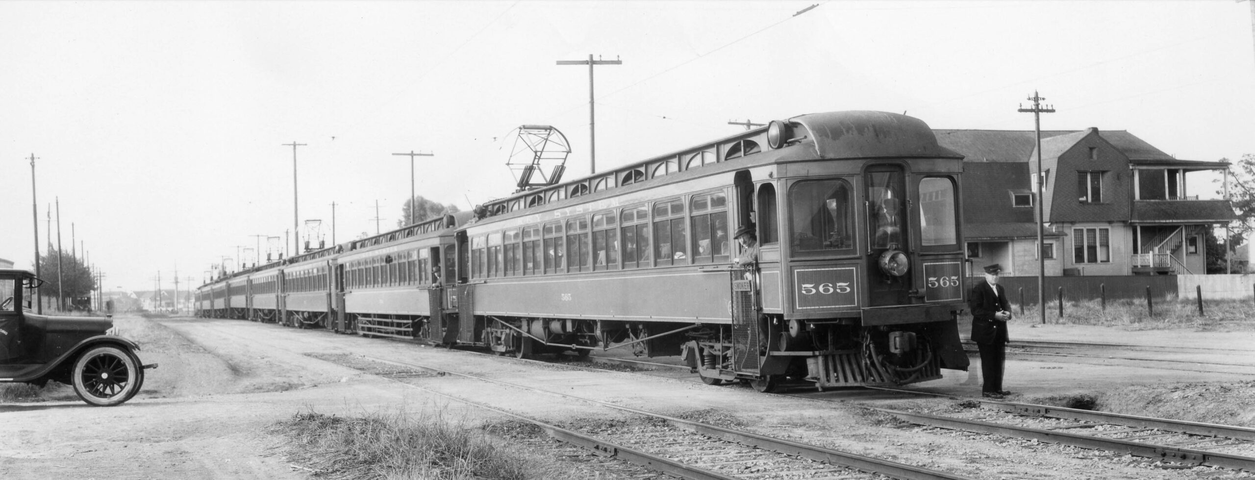
Evidence that this house was composed of two flats is provided by the presence of the back stairway seen in the only southwest view of the structure found. KS 565 led eight-car Claremont train waits at 43rd St. before heading toward the Claremont Hotel in the early 1920s.
L275-135-William E. Gardnier Photo, Courtesy BAERA, Western Railway Museum Archives, 88943ks, (Image 29 of 34)
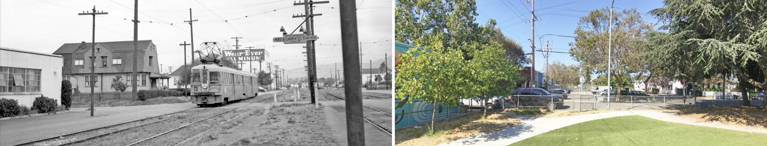
The resident at no. 4009 was not listed after 1953, and the one at no. 4011 had moved to Ayala St. by 1956. The northeast image in the left panel of KS 155, F line, at 43rd St. shows the house in question on Apr. 6, 1952 north of 43rd St. from Hobbs Battery Co., The sign indicates an E line stop at 43rd St. A similar matching view from 2022 shows a building on the former house lot, Border Lofts, 1000 43rd St. Note how Linden St. shifts to the west north of the park.
L275-140-Aitkin Coll., Courtesy BAERA, W. Railway Museum Arch., 163338ks, and Stuart Swiedler Photo, (Image 30 of 34)
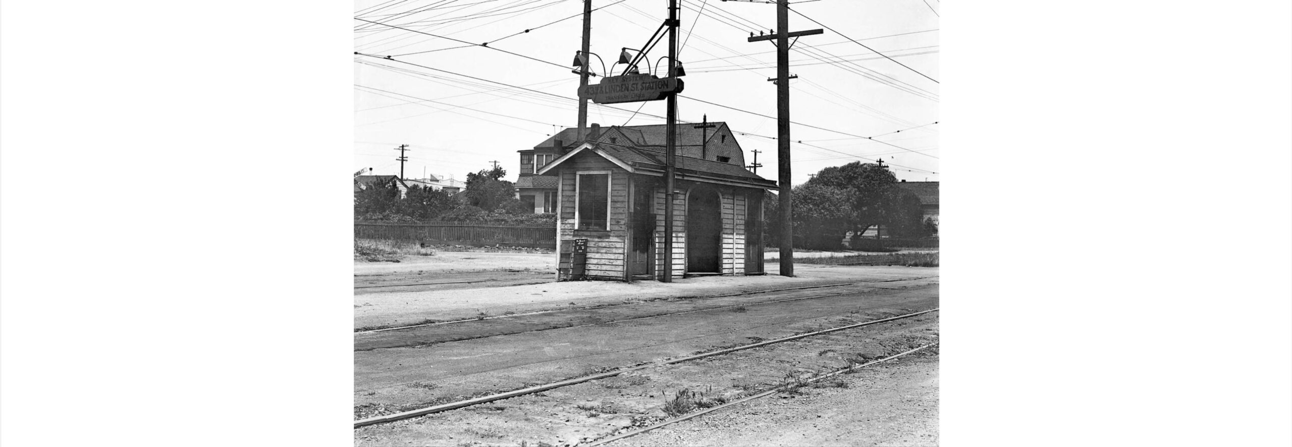
Prior to around 1941, the Claremont or E line had a shelter associated with the stop at 43rd. St., here shown in a north view from 1934. The paper stand indicates the SF Chronicle is 5 cents daily and 10 cents Sunday. The entire square block of 43rd-44th.-Linden-and Adeline Sts. had been totally comprised of residences into the mid-1950s as shown in L275-130.
L275-145-Key Official Photo, Sappers Coll., Courtesy BAERA, W. Railway Museum Archives, 171250ks , (Image 31 of 34)
Ahead to 43rd St., Vic DuBrutz’s northeast view of KS 127, F line, on July 13, 1957. The house at no. 4309-4311 has been replaced by a commercial building at no. 1000 43rd St., occupied by J Rothchild and Co., General Merchandise, and Border Lofts in 2022. Across on the east side, the large building toward 44th St., no. 995 44th St., was the Liberty Italian Club, Inc. circa 1953-1967, building no. 13, the Humanity Community Baptist Church in 2022. The image on the right by John Harder from Nov. 27, 2004 shows the west of Linden St. vacated for the parking lot and basketball courts, as the street shifts back to the east.
L275-150-Vic DuBrutz Photo, Courtesy BAERA, W. Railway Museum Arch., 71377ks, and John Harder Photo, (Image 32 of 34)
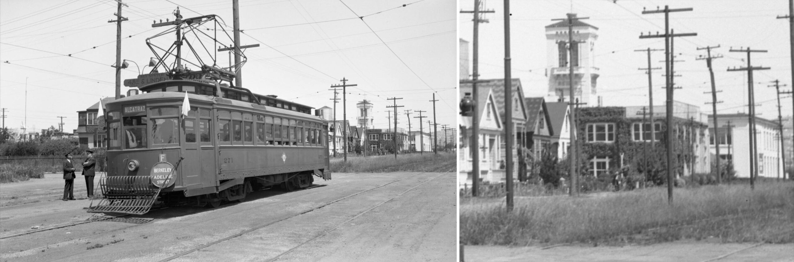
Louis Bradas. Jr.’s north view of KS 271 on excursion sporting the F line disk on May 18, 1941 reveals four of five houses on the west side of Linden St. between 44th and 45th Sts., labeled no. 14, dating back to the 1890s, nos. 4403-4419.
L275-155-Louis Bradas. Jr. Photo, Courtesy BAERA, Western Railway Museum Archives, 66432ks, (Image 33 of 34)
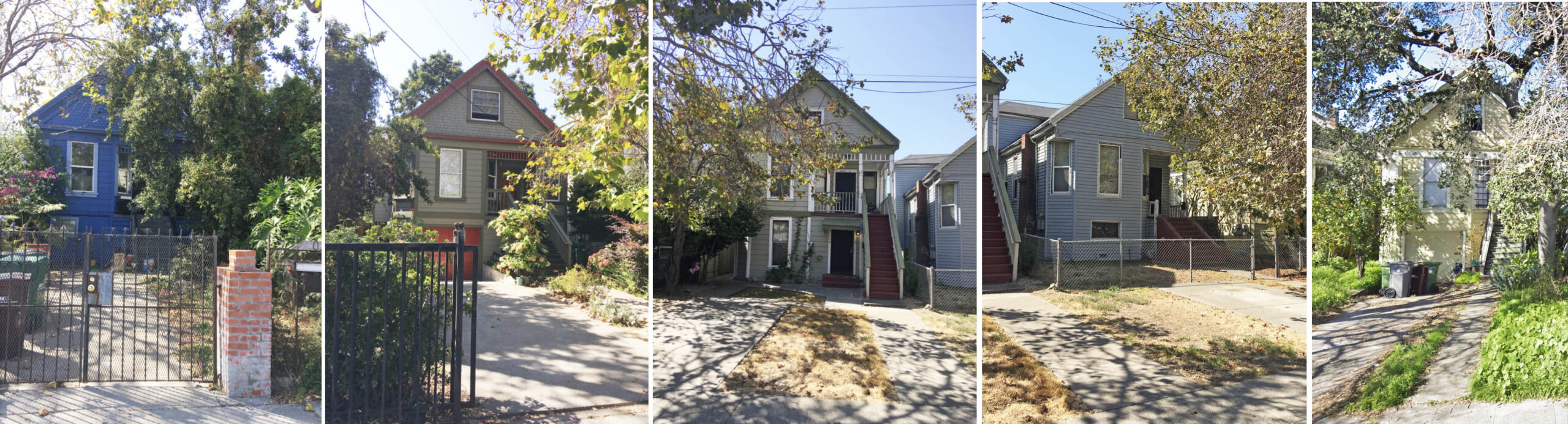
Ahead to 2022, northwest views of nos. 4403-4419. In 1931, this square block of 44th-45th-Linden-Adeline Sts. was also totally residential, but there was an empty northeast lot at the corner of 44th St. That was eventually filled in with a small industrial building in the 1950s, no. 4425, occupied by Abardean Plastics and Chemicals and the Plastics Training Center. Appreciation to John Harder for images and insights, and to Ron Hook who maintains the Key System albums at the Western Railway Museum. Next time, the review of the cut continues north of 45th St.
L275-160-Stuart Swiedler Photos, and Courtesy Google Maps, far right only, (Image 34 of 34)