Walnut Creek
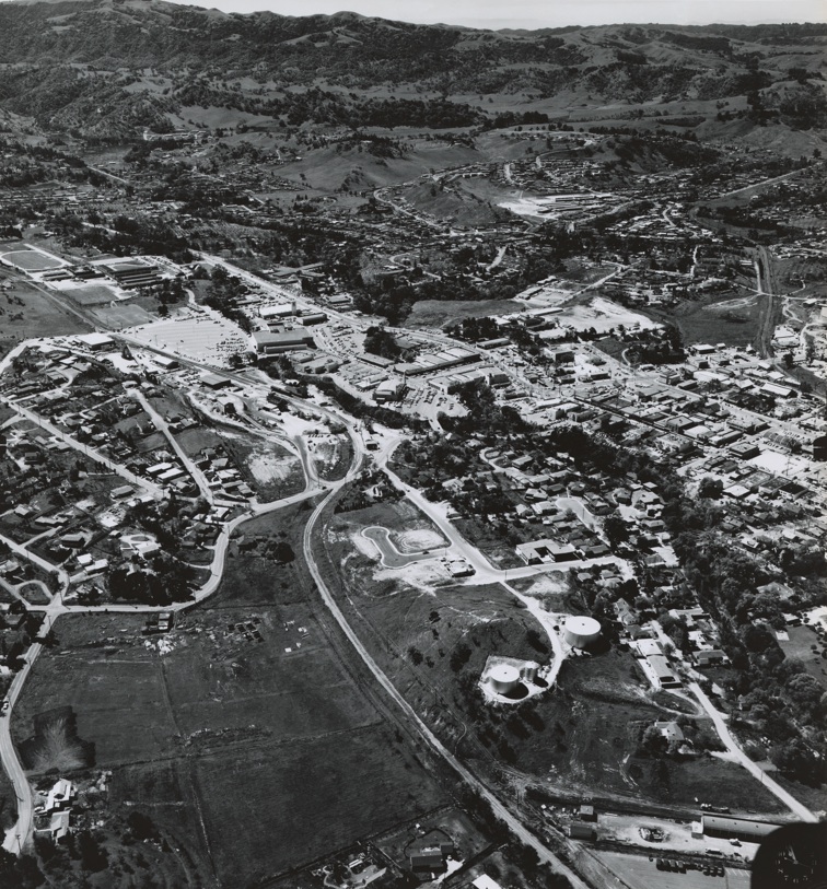
This east-oriented aerial from Mar. 3, 1952 reveals the SN railroad path through Walnut Creek, from Alpine Road, right, approaching the grade crossing at N. Main Street, upper left.
J5-Copyright California Department of Transportation, Detail 2481-1, (Image 1 of 19)

The Broadway Plaza Shopping Center, left center, bordered by the SP railroad signaled growth in Walnut Creek, southwest view circa 1955-56. Ref. #41, BANC PIC 1993.004, CC-C19-91.
J10-Clyde Sunderland Photo, Courtesy of The Bancroft Library, University of California, Berkeley, (Image 2 of 19)
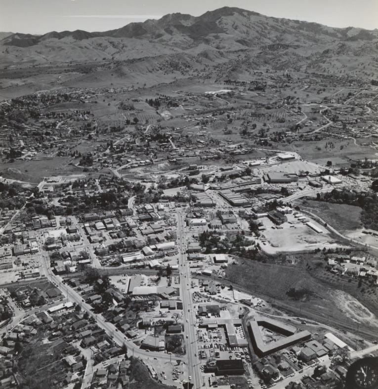
North view of Walnut Creek from Apr. 9, 1953. From left to right, the SN, the Danville Highway-N. Main Street, and the SP Railroad form long paths running north, respectively. Clock signature at the bottom right suggests a Clyde Sunderland photo.
J15-Copyright California Department of Transportation, 3299-1 , (Image 3 of 19)
Looking straight east down Mt. Diablo Blvd. circa 1955-56 contrasts the growing city against the open hills and Mt. Diablo in the background. Ref. #45 BANC PIC 1993.004 CC-C19-87.
J20-Clyde Sunderland Photo, Courtesy of The Bancroft Library, University of California, Berkeley, (Image 4 of 19)
The creeks dominated the shopping center and Mt. Diablo Blvd.’s eastern terminus in this southwest view from on Apr. 9, 1953. Note the SP Railroad’s operation and construction of Capwell’s, left edge. Clock signature suggests Clyde Sunderland photo.
J25-Copyright California Department of Transportation, Detail 3299-3 , (Image 5 of 19)
Detailed close-up of an east-oriented aerial of the SN-Mt. Diablo Blvd intersection showing SN spurs to local industry up to Bonanza Street, from Feb. 7, 1952. More on this intersection later ...
J30-Copyright California Department of Transportation, Detail 2477-15 , (Image 6 of 19)
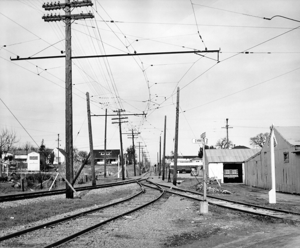
A north view of the right-of-way from Cypress Ave., now St., circa 1950.
J32-Courtesy BAERA, Western Railway Museum Archives, 75633sn, (Image 7 of 19)
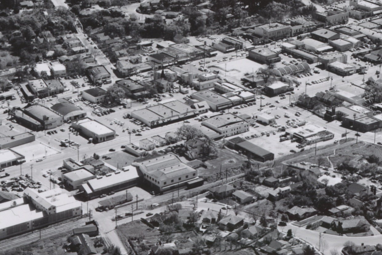
The SN continued north through central Walnut Creek on what is now N. California Blvd, from Mt. Diablo Blvd., right corner, to Cole Ave., left edge, as seen in this northeast-oriented aerial from Mar. 3, 1952. More details on buildings later ...
J35-Copyright California Department of Transportation, Detail2481-1, (Image 8 of 19)
A bird's-eye east view circa 1955-56 provides a different view of same subject as in J35. Ref. #42, BANC PIC 1993.004 CC-C19-90.
J40-Clyde Sunderland Photo, Courtesy of The Bancroft Library, University of California, Berkeley, (Image 9 of 19)
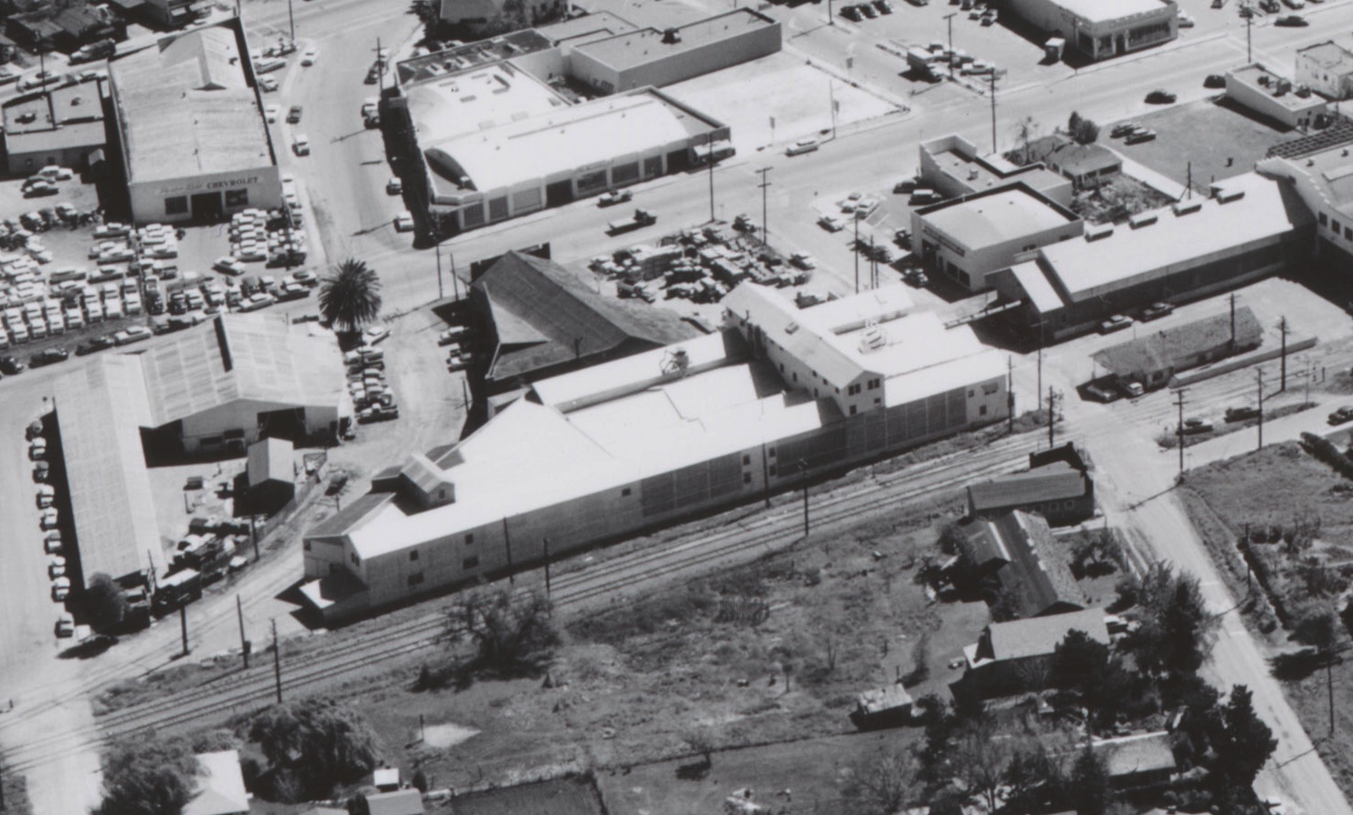
A detail of J40, east view circa 1955-56, shows the SN Walnut Creek Station. This location today would approximate the southeast corner where N. California Drive meets Civic Dr. and Trinity Ave. Detail Ref. #42, BANC PIC 1993.004 CC-C19-90.
J45-Clyde Sunderland Photo, Courtesy of The Bancroft Library, University of California, Berkeley, (Image 10 of 19)
The neighbors of the SN station played a key role in the 20th century for local agricultural products, particularly walnuts. More on this later ... Detail Ref. #42, BANC PIC 1993.004 CC-C19-90.
J50-Clyde Sunderland Photo, Courtesy of The Bancroft Library, University of California, Berkeley, (Image 11 of 19)
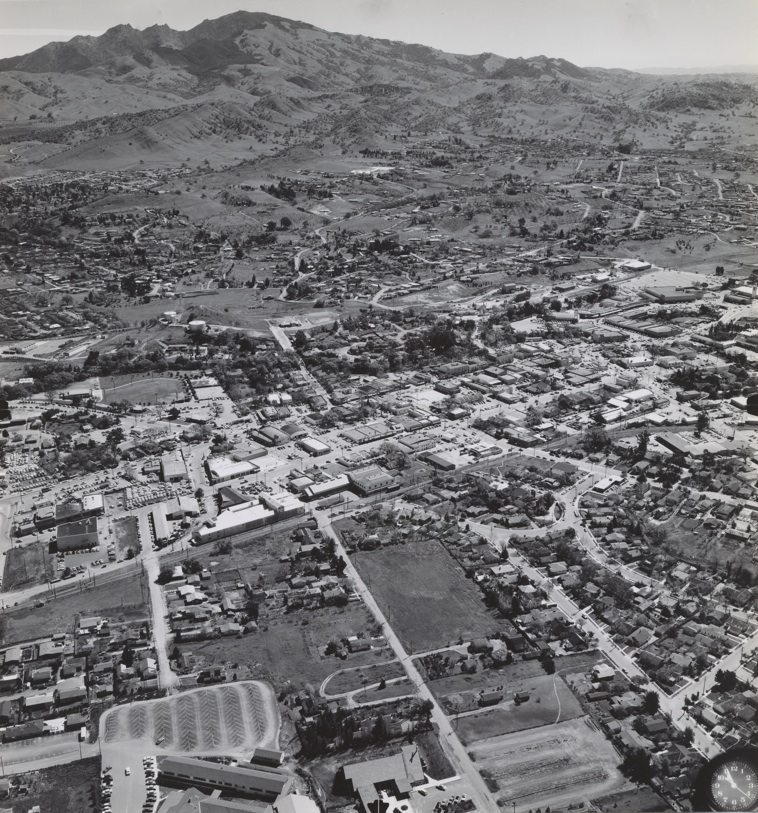
Northwest view of Walnut Creek from Apr. 9, 1953 provides another angle of the SN Walnut Creek Station locale, lower right, out to the present location of Ygnacio Blvd.
J55-Copyright California Department of Transportation, Detail 3299-2, (Image 12 of 19)
This east-oriented view from March 3, 1952 covers the area from the SN train station, right edge, to the SN crossing of N. Main Street, upper left. The next image provides annotations for key streets and BART.
J60-Copyright California Department of Transportation, Detail 2481-2, (Image 13 of 19)
Annotated version of J60 shows the position of the SN relative to the position taken by BART. With the addition of BART and I-680, several of the streets, including Pringle and Oakland Blvd., were slightly modified from the positions shown in this image.
J61-Copyright California Department of Transportation, Detail 2481-2, (Image 14 of 19)
Detail of SN grade crossing of N. Main Street, east-oriented view, February 7, 1952.
J65-Copyright California Department of Transportation, 2477-24, (Image 15 of 19)
A look at the new freeway, I-680, at Oak Park Blvd. from this south view, Apr. 4, 1957. SN service between Oakland and Walnut Creek has ceased, but this section will remain in operation until BART claims it as their right-of-way.
J70-Copyright California Department of Transportation, C198-1, (Image 16 of 19)
Detail of J70 at Geary Rd.-Treat Blvd. shows the SN meeting the SP line, lower left, at Las Juntas-Sparkle, Apr. 4, 1957. The California Legislature approved creation of the five-county BART District two months later on June 4. Ref. http://www.bart.gov/docs/BARThistory.pdf
J76-Copyright California Department of Transportation, Detail C198-1, (Image 17 of 19)
Looking north at the new freeway, Apr. 4, 1957. The road crossing the SN at the bottom, right, is Walden Way, the site of the prior SN Walden Station.
J80-Copyright California Department of Transportation, C198-2, (Image 18 of 19)
This detail of J80, north view Apr. 4, 1957, shows the SN separating from the freeway at the north side of Treat Blvd., the site of the present day Pleasant Hill BART station. The SN is seen crossing the SP line, and then meeting the Walnut Creek at the very edge of the right upper corner, just short of Bancroft Road, also the site of a prior SN station.
J85-Copyright California Department of Transportation, Detail C198-2, (Image 19 of 19)