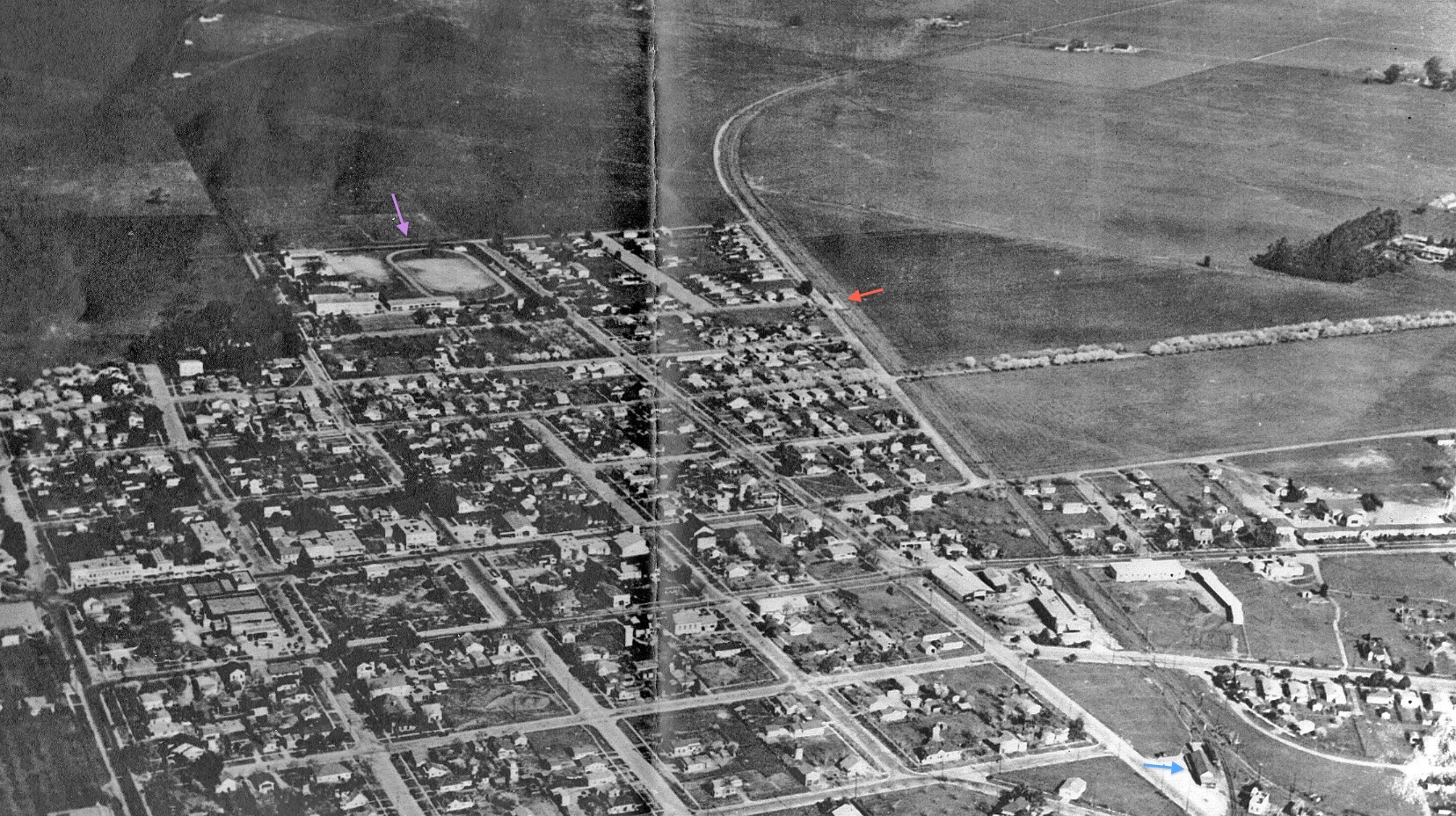
Why Students Took the SN to Mt. Diablo High School

High above Concord circa 1935 and heading north of the Concord depot, blue arrow, was the SN Bacon St. shelter, red arrow. Students walked west down the latter street to access Mt. Diablo High School, purple arrow. From 1935 until mid-1941, the SN provided the only passenger train stop in walking distance to the high school.
L139-05-Courtesy Western Railway Museum Archives, 98603sn, (Image 1 of 18)

The SP ended passenger service on the San Ramon line in 1934, but the 1939 map shows the SN Bacon St. shelter, yellow circle, was much closer to the high school, enclosed by the red rectangle, relative the position of the Southern Pacific Concord depot, black circle. Although a moot point, the school’s growth closed that gap with time as seen in the companion aerial from 1965.
L139-10-Courtesy Google Earth and the National Archives of San Francisco, (Image 2 of 18)

Another comparison circa 1956 from a west view, the SP Concord depot and its two palm trees just a few years prior to demolition versus the bare spot left by the SN Bacon St. shelter. Try to find these locations prior to looking at the next annotated image.
L139-15-Clyde Sunderland Photo, Courtesy of The Bancroft Library, University of California, Berkeley, (Image 3 of 18)

West view circa 1956 showing the SP Concord depot, blue arrow, associated palm trees, purple arrow, and bare spots left after removal of SN Bacon St. shelter, yellow arrow. Ref: brk00017182_24a
L139-16-Clyde Sunderland Photo, Courtesy of The Bancroft Library, University of California, Berkeley, (Image 4 of 18)

The SN school trains were extremely popular right up to cessation of passenger service in mid-1941. Based upon the orientation of the trolley poles, this northeast view from the late 1930s appears to show a five-car no. 27 “School Special” led by SN 1014 with a separate two-car train at its rear pointing toward Pittsburg at the Bacon St. shelter. Alternatively, seven-car trains on the south end were unheard of.
L139-20-Paul Smith Photo, Courtesy BAERA, Western Railway Museum Archives, 102831sn, (Image 5 of 18)

Dudley Thickens took two pictures of a five-car school train on Jul. 6, 1940 at Bacon St., this one showing SN 1017 in a southwest view ...
L139-25-Dudley Thickens Photo, Courtesy BAERA, Western Railway Museum Archives, 101972sn, (Image 6 of 18)

... and this one of the other end of the train with SN 1012 in a northwest view, Jul. 6, 1940.
L139-30-Dudley Thickens Photo, Courtesy BAERA, Western Railway Museum Archives, 101971sn, (Image 7 of 18)

With the Bacon St. shelter already passed, a rare ground shot shows a SN train, here with SN 1011, heading toward West Pittsburg with the high school in the background, right. Southwest view, May 28, 1940.
L139-35-Wilbur Whittaker Photo, Courtesy Arnold Menke, (Image 8 of 18)

A southeast view circa 1956 over Mt. Diablo High School, the first public high school in Contra Costa County. Officially opened in Apr. 1901 a few blocks south, it opened at this site in 1904. Ref: brk00017184_24a
L139-40-Clyde Sunderland Photo, Courtesy of The Bancroft Library, University of California, Berkeley, (Image 9 of 18)

A Feb. 1993 north view up the Port Chicago Highway showing the initial construction of BART to the North Concord Station, this view close to where Bacon St. had once met the road. This intersection was long gone with expansion of the original Concord Hospital complex, seen on the left, leading to the creation of the John Muir Medical Center in the mid-1990s.
L139-50-Louis L Stein Photo, Western Railway Museum Archives, 103827BARTD, (Image 10 of 18)

The history of the area to the east of the Bacon St. shelter was interesting as well, here in a southeast view showing the government housing development, Eniwetok Village. According to John Keibel’s “Behind the Barbed Wire, History of Naval Weapons Concord”, it was constructed in 1945, transferred to the Navy in 1948, and razed 1966. Ref: brk00017185_24a
L139-55-Clyde Sunderland Photo, Courtesy of The Bancroft Library, University of California, Berkeley, (Image 11 of 18)

A detail from L139-55 shows the area devoid of grass marking the site of the former SN Bacon St. shelter, southeast view circa 1956. Ref: brk00017185_24a
L139-60-Clyde Sunderland Photo, Courtesy of The Bancroft Library, University of California, Berkeley, (Image 12 of 18)

Some detail is needed to confirm the duration of existence of the Bacon St. shelter. This south view of the right-of-way north of the high school circa 1923 is a starting point.
L139-65-Courtesy BAERA, Western Railway Museum Archives, 26068sn, (Image 14 of 18)

A detail from L139-65, a south view circa 1923, shows a clear right-of-way without any sign of a shelter.
L139-70-Courtesy BAERA, Western Railway Museum Archives, 26068sn Detail, (Image 15 of 18)

That is because the plans for the shelter did not materialize until late 1933. Although cost overruns were encountered in its construction, it appeared to be finished by mid-1934 based on several company letters; these are archived at WRM, Concord folder 38168sn.
L139-75-Courtesy BAERA, Western Railway Museum Archives, 38618sn, (Image 16 of 18)

The shelter’s demise and elimination in 1941 can be gleaned by these two SN-internal memos. The end of the school train north of the shelter ended its usefulness, probably compounded by the opportunity of those living south of Concord to attend Acalanes High School starting in 1940.
L139-80-Courtesy BAERA, Western Railway Museum Archives, 38618sn, (Image 17 of 18)

Leaving this subject, here with a northeast view circa 1956 showing the big curve of the Port Chicago Highway leading to Dorenda, Adeline and much more. Ref: brk00017183_24a
L139-85-Clyde Sunderland Photo, Courtesy of The Bancroft Library, University of California, Berkeley, (Image 18 of 18)