Why The Backyards Face Olympic Boulevard

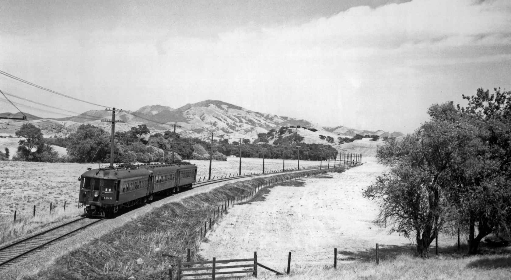
With Mt. Diablo as a backdrop, SN 1012 has left the Saranap station at Tice Valley Boulevard and approaches the Saranap-Lafayette border at the Pleasant Hill cut, east view, June 18, 1939. Note no roads, no homes, just Las Trampas Creek where most of the trees are concentrated.
L129-05-Wilbur C Whittaker Photo, Courtesy Tom Gray and Garth Groff, (Image 1 of 9)

In 2016, looking east down Olympic Blvd. at the position of the train in L129-05, left, the backside of the most westerly home on West Newell Ave. is seen. In the right panel, an east view from the intersection of Olympic Blvd. and Windtree Ct. also shows the back of houses. There is no entry to these homes from Olympic Blvd.
L129-10-Stuart Swiedler Photos, (Image 2 of 9)

This vertical aerial, north at the top, shows Olympic Blvd. on Oct. 30, 2015 from Pleasant Hill Rd., far left, past the Pleasant Hill cut, up to the origins of Newell Ct., West Newell Ave., and Newell Ave., far right. Note that all of the homes along Olympic Blvd. are entered by other roads.
L129-15-Courtesy Google Earth, (Image 3 of 9)

This map from 1953 shows the SN right-of-way at the Lafayette-Saranap border, now the route of Olympic Blvd. The green arrow marks the current position Pleasant Hill Rd. which also did not exist. West Newell Ave. was just part of Newell Ave. Any homes built at this time were approached by the roads they were built on.
L129-20-Thomas Bros. Popular Atlas of CCC, Courtesy Pleasant Hill Library, (Image 4 of 9)

Dudley Thickens made it clear in his east views from the Pleasant Hill cut in 1937, SN 1017 as a two-car train, Feb. 28, 1937, and 1957, an excursion with SN 1005 and Salt, Lake and Utah 751, Jan. 13, 1957, that new homeowners on what is today West Newell Ave. had no incentive to create easy access toward the SN to the north.
L129-25-Dudley Thickens Photo, Courtesy BAERA, Western Railway Museum Archives, 94717sn and 59996sn, (Image 5 of 9)

West Newell Ave. was created as an extension of Newell Ave. in 1949, and this image of an east view of a freight led by SN 661 from Oct. 1949 is consistent with home construction being completed in that year as well.
L129-30-Dudley Thickens Photo, Courtesy BAERA, Western Railway Museum Archives, 94723sn, (Image 6 of 9)

Another image of SN 661 with freight, but this time in a west view toward the Pleasant Hill cut in 1949, with the most westerly constructed homes in view. Cliff Baumer, whose parents purchased 2757 Newell Ave. on the south side of the street that year, noted that this one block section was part of the Sun Valley development, and the postal address was served by Walnut Creek.
L129-35-Dudley Thickens Photo, Courtesy BAERA, Western Railway Museum Archives, 4602sn, (Image 7 of 9)

Appreciate that most of the homes on what is today West Newell Ave. were from that original 1949 construction. Although still assigned Walnut Creek postal addresses, it is comforting to know that at least some folks wouldn’t consider this anything else but Saranap.
L129-40-Stuart Swiedler Photos, (Image 8 of 9)

Homes added after the SN was abandoned in 1958 and Olympic Blvd. was completed in 1964 between Reliez Station Rd. and the intersection with Tice Valley Blvd.-Boulevard Way carried on the tradition of not having their front doors open to that road, such as the development west of Pleasant Hill Rd. shown in an east view here. It was an orchard after the SN left town. A memorial to something special that passed through Saranap many years ago.
L129-45-Stuart Swiedler Photo, (Image 9 of 9)